Cappadocia Drone Photography: Balloons, Chimneys & Dawn

Cappadocia Drone Photography: Balloons, Chimneys & Dawn

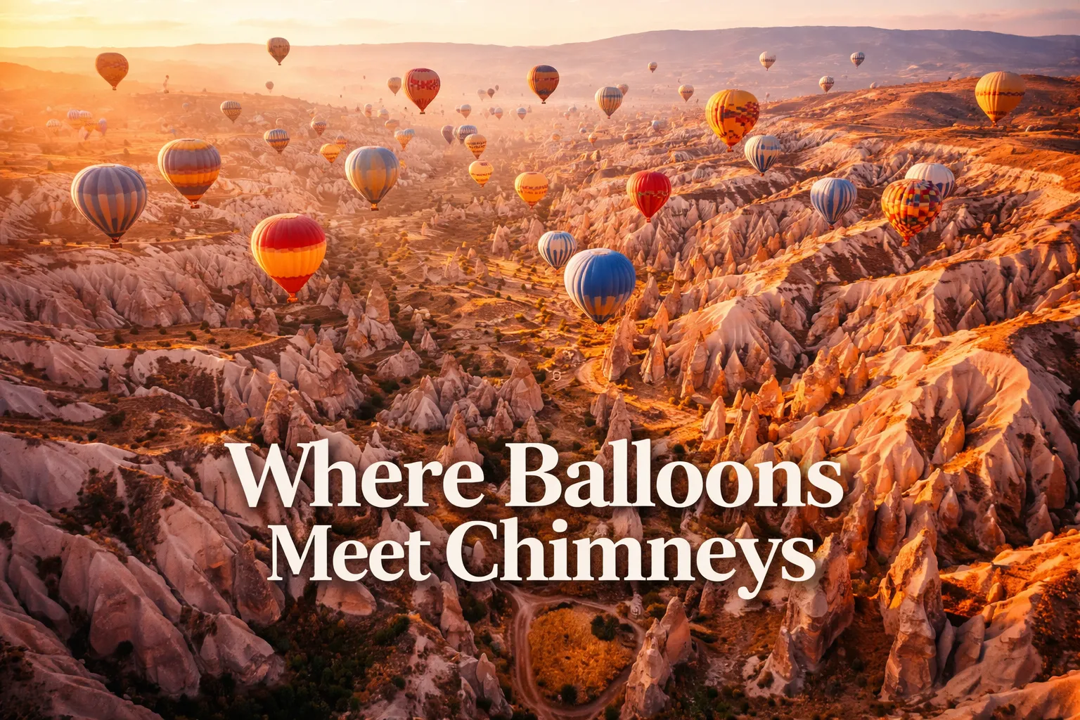
The moment my drone cleared the rooftop of my cave hotel in Göreme and I saw Cappadocia from above for the first time, I genuinely stopped breathing. Below me, rippling out in every direction, was a landscape that looked designed by a fever dream — thousands of pale volcanic spires clustered in valleys, carved cave … Read more

Plitvice Lakes Drone Photography: Croatia From Above

Plitvice Lakes Drone Photography: Croatia From Above

Field Details GPS Coordinates (Park Center) 44.8800° N, 15.6200° E Recommended Altitude Range 80–250m AGL for full lake system; 40–80m AGL for waterfall detail shots Best Time of Day 7:00–9:30 AM (golden hour light hits the water surface at low angles; mist rises off Upper Lakes) Best Season Late April–May (snowmelt maximizes waterfall volume); October … Read more

Zhangjiajie Avatar Mountains: Drone Photography Guide

Zhangjiajie Avatar Mountains: Drone Photography Guide

Zhangjiajie Avatar Mountains Drone Photography: What It’s Like to Fly Above the Floating Pillars The moment my drone cleared the treeline above Yuanjiajie Scenic Area and I looked down at my controller screen, I genuinely forgot to breathe. Nothing — no photograph, no film clip, no description — had prepared me for what zhangjiajie avatar … Read more

Salar de Uyuni Drone Photography: Bolivia’s Mirror Earth

Salar de Uyuni Drone Photography: Bolivia's Mirror Earth

Detail Information GPS Coordinates (center of salar) 20°08′ S, 67°29′ W Recommended Altitude Range 30–150m for mirror compositions; 100–300m for geometric salt patterns and wide landscape shots Best Time of Day to Fly 30 minutes after sunrise (golden light on the salt crust) and 45 minutes before sunset; avoid midday (harsh white overexposure) Best Season … Read more

Santorini Drone Photography: Greece From Above

Santorini Drone Photography: Greece From Above

Primary GPS Coordinates Oia: 36.4618° N, 25.3753° E | Fira: 36.4168° N, 25.4313° E | Caldera offshore: 36.4000° N, 25.3600° E Recommended Altitude Range 80–180m for architectural detail; 180–400m for full caldera overview (subject to local airspace restrictions) Best Time of Day Golden hour (45 min before sunset) and blue hour (20 min post-sunset); early … Read more

Ha Long Bay Drone Photography: Vietnam From Above

Ha Long Bay Drone Photography: Vietnam From Above

The moment my drone cleared the deck railing of our junk boat and climbed above the first limestone tower, I genuinely forgot to breathe. Ha long bay drone photography in Vietnam is one of those experiences that resets your understanding of what “landscape” means — because from 150 meters up, Ha Long Bay doesn’t look … Read more

Victoria Falls Drone Footage: Zambia & Zimbabwe From Above

Victoria Falls Drone Footage: Zambia & Zimbabwe From Above

The first time I sent my drone up over Victoria Falls, I genuinely forgot to breathe. I’d seen hundreds of ground-level photographs, stood on the lip of the gorge with mist soaking through my jacket, and still nothing prepared me for what the screen showed when the drone climbed to 150 metres. The Zambezi River … Read more

Angkor Wat Drone Photography Cambodia: The God’s-Eye View

Angkor Wat Drone Photography Cambodia: The God's-Eye View

GPS Coordinates (Main Temple) 13.4125° N, 103.8670° E Recommended Altitude Range 80–200m (with permit); 100–150m optimal for composition Best Time of Day to Fly 5:00–6:30 AM (pre-sunrise to golden hour); thermal turbulence builds sharply after 8:00 AM Best Season November–February (dry season; low humidity, stable air, soft morning light) Drone Regulations Summary Permits required via … Read more

The Oldest Living Organism in the World Is a Seagrass You Can Snorkel

The Oldest Living Organism in the World Is a Seagrass You Can Snorkel

There is a meadow of seagrass growing between the islands of Ibiza and Formentera, in the turquoise shallows of the Balearic Sea, that is approximately 100,000 years old. One hundred thousand years. That means this single plant — one genetic individual, a clonal organism spreading its identical cells across 8 kilometers of Mediterranean seafloor — … Read more

Taj Mahal Drone Photography: The Aerial View Worth Knowing

Taj Mahal Drone Photography: The Aerial View Worth Knowing

There is a moment — and I will never forget it — when you pull up satellite imagery of the Taj Mahal for the first time and genuinely stop breathing. From altitude, this is not merely a beautiful building. It is a geometric argument, a philosophical statement carved in white marble and laid out across … Read more