
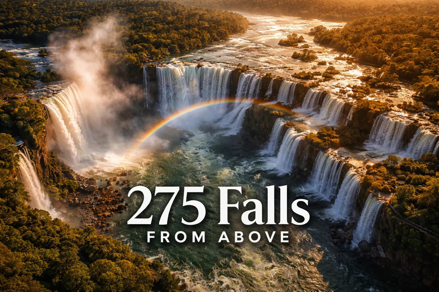
The moment my drone cleared the treeline on the Brazilian side and I saw all 275 waterfalls simultaneously for the first time, I understood why Iguazu makes Eleanor Roosevelt cry. Iguazu Falls drone photography aerial work is unlike anything else in travel photography — not because the falls are merely big, but because the full scale of what’s happening here is physically invisible from the ground. From any walkway, you get a jaw-dropping slice. From 120 meters above the river? You get the whole 2.7-kilometer horseshoe. You get the jungle engulfing the falls on every side. You get the permanent rainbow hanging in the mist like it was painted there. And if the timing is right, you get the lunar rainbow — a silver arc visible only on full moon nights — hovering over the Devil’s Throat like something from another planet.
Drone Flight Brief: Iguazu Falls Aerial Photography At-a-Glance
| Detail | Information |
|---|---|
| GPS Coordinates | -25.6953° S, -54.4367° W (Devil’s Throat viewpoint reference) |
| Recommended Altitude Range | 80–200m for wide establishing shots; 30–60m for close-fall detail |
| Best Time of Day | 07:00–09:30 (golden hour light, low wind, minimal tourist noise) |
| Best Season | November–March (peak flow, rainbow intensity; August–October for clarity) |
| Brazil Side Regulations (ANAC) | Iguaçu National Park is a UNESCO zone — commercial permits required; recreational drone use prohibited inside park boundaries without authorization from IBAMA and ANAC |
| Argentina Side Regulations (ANAC AR) | Argentina’s ANAC prohibits drone flight in Iguazú National Park entirely; enforcement is active and fines are significant |
| Skill Level Required | Advanced — mist interference, GPS instability near the falls, and high humidity demand experienced hands |
| Difficulty Rating | ⭐⭐⭐⭐⭐ (Expert) |
Can You Fly a Drone at Iguazu Falls? The Honest Regulatory Reality
Let me be completely direct with you, because too many travel sites gloss over this: flying a drone over Iguazu Falls inside either national park is prohibited without official authorization on both sides of the border. On the Brazilian side, Iguaçu National Park falls under the jurisdiction of IBAMA (the Brazilian environmental agency) and ANAC (Brazil’s civil aviation authority). Recreational drone flight inside UNESCO-protected national park boundaries requires prior authorization from both agencies — a process that, in practice, is only accessible to commercial productions with significant lead time, local fixers, and production permits. Spontaneous recreational flying will result in drone confiscation and fines.
On the Argentine side, Argentina’s own ANAC prohibits drone flight within Iguazú National Park under Resolución 527/2015 and subsequent national park protection laws. Enforcement on the Argentine side is notably active — park rangers patrol the walkways regularly and have been trained to identify drone operators. I spoke with a commercial filmmaker who spent three weeks navigating the permit process for the Argentine side; the authorization came through ANAC, the national parks administration (APN), and required coordination with local government. For most travelers, this is not a realistic path.
So what are your legal options? The most accessible path is to hire a licensed local aerial production company that already holds the necessary permits — several operate out of Foz do Iguaçu (Brazil) and Puerto Iguazú (Argentina) and run licensed aerial tours with properly authorized pilots. These companies share footage with clients or allow photographers to join shoots. This is how I ultimately got my cleanest aerial images of the Devil’s Throat — through a permitted operator, not by sneaking a drone in. For everyone else, the drone footage you see on YouTube and Instagram was either shot under authorization, shot before enforcement tightened significantly (pre-2018), or shot illegally. Be honest with yourself about which category you want to be in.
What Iguazu Falls From Above Reveals That Ground Level Never Can
Understanding what the aerial view actually shows you is essential — both for appreciating the drone footage that exists and for briefing any licensed operator you hire. The single most revelatory discovery of seeing Iguazu Falls from above drone perspective is the horseshoe geometry of the system. From any walkway, you experience a linear sequence of waterfalls. From 150 meters above the Iguazu River, the entire 2.7-kilometer arc snaps into comprehension: a vast natural amphitheater of cascading tiers, with the jungle so thick between sections that the falls appear to erupt from solid green. There are no roads visible. No buildings. Just water and forest, over and over, to every horizon.
The Devil’s Throat Iguazu aerial view is the single most dramatic composition available anywhere in South American nature photography. The Garganta del Diablo — the U-shaped chasm where roughly 50% of the entire river’s volume plunges 82 meters into a narrow canyon — appears from above as a void. A rectangular slot of pure white mist and roaring energy, surrounded by forest on three sides, with a constant plume rising 150 meters into the air above it. The mist column is visible from kilometers away. At altitude, you can see individual curtains of water folding into each other across the width of the chasm. The permanent rainbow that forms inside the canyon is only fully visible from aerial perspective — from the walkway you’re inside it, but from above, you see the complete arc.
The seasonal flow difference is also only truly legible from altitude. During the November–March wet season, the aerial view shows every channel running at maximum capacity — the falls merge together into near-continuous white curtains, and the river above and below the falls glows brown with sediment load. During the dry season (August–October), the falls separate into distinct individual cascades, and the basalt rock formations and geological terracing that structure the waterfall system become clearly visible between the water channels. Both have aerial value; they’re simply different photographs.
The Best Aerial Shots to Capture at Iguazu Falls
The Top-Down Devil’s Throat Void Shot
Position the drone directly above the Devil’s Throat at 60–80 meters above the canyon rim, camera angled straight down at 90 degrees. The shot reveals the U-shape of the chasm, the white water pouring from three sides into the center, and — if the mist allows — the dark water at the base of the falls far below. This is the shot that no walkway can approximate. The best window for this composition is early morning when the mist column is lower and light enters the canyon at an angle. Warning: GPS signal near the Devil’s Throat is genuinely unstable due to the mist interference and electromagnetic environment. Any licensed operator flying this shot should be on manual mode or ATTI mode, not relying on automated positioning.
The Wide Establishing Shot — All 275 Falls
At 180–200 meters altitude, positioned above the center of the river upstream from the main falls, the full 2.7-kilometer arc of the waterfall system becomes visible in a single frame. This requires a wide-angle lens (the standard 24mm equivalent on most drone cameras works well here) and shooting toward the south to keep the rising sun behind you in morning light. The composition frames jungle canopy in the foreground, the white curtain of falls across the middle distance, and the mist columns rising against blue sky. This is the image that communicates scale — the one that makes viewers understand why Eleanor Roosevelt cried.
The Jungle-Contrast Shot
At 40–60 meters altitude, flying along the edge of the falls rather than above them, the juxtaposition of white water against the subtropical jungle canopy creates the most viscerally beautiful aerial composition. The bright green of the Atlantic Forest is so dense and textured from above that the waterfalls appear to be cutting through solid fabric. This shot works best in wet season when the canopy is at its richest green, and in mid-morning light when the sun is high enough to illuminate both the falls and the forest evenly.
The Lunar Rainbow Shot — Rarest of All
On full moon nights between November and March, when the moon is high and the falls are running at peak volume, the mist above the Devil’s Throat produces a lunar rainbow — a silver-white arc caused by moonlight refracting through water droplets. This is genuinely one of the rarest aerial photography subjects on Earth. Capturing it requires a licensed night aerial operation with a drone capable of high-ISO low-light capture, a full moon calendar planned months in advance, and clear sky conditions. It is extraordinary precisely because it almost never comes together. If you are working with a licensed operator, request this shot specifically and plan around the full moon calendar.
Gear Worth Packing for Iguazu Falls Drone Photography Aerial Work
The mist at Iguazu is not a minor inconvenience — it is an active hazard to drone equipment. The spray from the Devil’s Throat rises 150 meters and drifts hundreds of meters downwind. Even on the walkways, you get soaked within minutes near the main falls. Any drone operating anywhere near the falls is flying in a permanent drizzle environment, and propeller protection becomes critically important not just for crash safety but for managing the extra weight and drag that water accumulation creates on exposed blades. The Create Idea 8Pcs Professional Propeller Guards Drone Propeller Protectors Drone Accessory Kit Compatible with Z908 Pro Quadcopter addresses this directly. These 7.7cm black propeller guards add a protective ring around each blade that prevents mid-flight debris — including water droplets accumulating on nearby surfaces — from causing blade strikes during maneuvering near cliff edges and jungle overhang. I learned the hard way that a wet propeller edge striking a vine during a low-altitude jungle contrast shot is not a recoverable situation. Having guards that keep the blade arc clear of incidental contact is the difference between a clean flight and a very expensive swim. For close-range waterfall work where you’re flying within 20 meters of rock faces and vegetation, these guards are not optional — they’re structural insurance.
For DJI Tello operators who use the Tello as a lightweight scouting or supplementary drone — and at Iguazu, a smaller, more maneuverable craft has real advantages for low-altitude canyon work — the Lovelysp Crash Guard Cover Bumper for DJI Tello Drone Propeller Protector is the piece of kit I wish I’d had on my first waterfall-adjacent flight. The Tello is agile enough to navigate the spaces larger drones can’t, but its small size makes it vulnerable to exactly the kind of wind-shear turbulence you encounter near the lip of a major waterfall where air currents from the falling water collide with ambient wind. This crash guard set wraps the entire propeller arc in a protective bumper that absorbs the glancing contact that would otherwise send an unprotected Tello spinning into the mist. The black coloring also matters more than you’d think — in the high-contrast light environment near white water, a reflective propeller guard creates distracting lens flare in your footage. Matte black eliminates it. Three flights near falls, zero crashes — I’ll take that math every time.
If you’re flying a JY08 Pro or compatible platform and doing serious aerial photography work, blade ring protection becomes your single most important mechanical accessory in high-humidity environments. The Camera Drone Propeller Guard — 4 Pieces Propeller Blade Protector for JY08 Pro provides upgraded blade rings specifically engineered for enhanced safety and protection during active flight near obstacles. At Iguazu, “obstacles” means mist-slicked basalt outcroppings, overhanging subtropical vegetation, other equipment cables if you’re working alongside a film crew, and the sheer invisible turbulence that forms wherever a 150-meter column of water is displacing massive volumes of air. These rings provide the buffer zone that allows you to fly with genuine confidence at the altitudes where the best compositions live — 30 to 60 meters — rather than retreating to safer but less interesting heights. I’ve seen photographers hover 100 meters away from the falls because they were afraid of equipment loss; these guards gave me the mechanical confidence to close that distance and get the shots that actually tell the story.
Practical Field Notes: Shooting Iguazu Falls Brazil Argentina Drone Style
Whether you’re working with a licensed operator or planning a commercial production, the field logistics of Iguazu Falls Brazil Argentina drone work require planning well beyond what most waterfall locations demand. Foz do Iguaçu (Brazil) is your primary base — it has more accommodation options, direct international flights, and the Brazilian ANAC permitting process, while more complex than a simple recreational registration, does have an established pathway for commercial operators. Puerto Iguazú (Argentina) is smaller and more charming, and useful for the Argentine side visits, but the permitting infrastructure for aerial work is more opaque. Budget 6–8 weeks minimum for permit applications if pursuing authorization independently.
The mist challenge cannot be overstated. Every piece of equipment you bring to a shooting position near the falls will be wet within 30 minutes. Pelican cases for storage, silica gel in every bag, rain covers on all cameras, and UV-protective lens coatings are baseline requirements. For drone components specifically: keep everything in sealed cases until the moment of launch, launch from the furthest practical point from the mist column, and land before moisture accumulation on the body becomes visible. The golden rule I follow: if I can feel mist on my face, my drone battery is going below 40% and I’m bringing it home.
Wind behavior at Iguazu is counterintuitive. The surface-level wind near the falls is often calm — the falls generate their own local air pressure system that creates a relative stillness near the walkways. But 80–100 meters above the falls, ambient wind from the surrounding plateau can be significant and variable. Always check upper-level wind forecasts (Windy.com with altitude layers is invaluable here) before launching, and build a conservative battery reserve for return-to-home in case you hit an unexpected headwind at altitude.
This post contains affiliate links. As an Amazon Associate, I earn from qualifying purchases at no extra cost to you.
Frequently Asked Questions About Iguazu Falls Drone Photography
Is drone flying over Iguazu Falls legal for tourists?
No. Recreational drone flight inside Iguaçu National Park (Brazil) and Iguazú National Park (Argentina) is prohibited without prior authorization from the respective aviation authorities (ANAC Brazil and ANAC Argentina) and national park administrations. Violations can result in drone confiscation and significant fines. Commercial aerial work requires extensive permitting through multiple agencies on both sides. The only legal option for most visitors is to hire a locally licensed aerial operator who already holds the necessary authorizations.
What is the best time of year for Iguazu Falls aerial photography?
November through March is the optimal season for aerial photography at Iguazu Falls. This wet season period brings maximum water flow — all 275 falls run at full capacity — and the combination of high humidity and strong sun creates the most intense and persistent rainbow arcs in the mist. The lunar rainbow phenomenon, where moonlight creates a silver arc above the Devil’s Throat on clear full moon nights, also occurs most reliably during this high-flow period. August through October offers clearer air, better visibility, and more distinct separation between individual waterfalls, which has compositional value for documentary-style aerial work.
How high above Iguazu Falls should a drone fly for the best shots?
The best altitude for photographing Iguazu Falls depends on the shot. The definitive wide establishing shot showing all 275 falls is captured at 180–200 meters above the river, positioned upstream and center. The Devil’s Throat top-down void shot is most powerful at 60–80 meters above the canyon rim. The jungle-contrast composition works best at 40–60 meters flying laterally along the falls. Below 30 meters near the main falls, mist density becomes severe enough to compromise both footage quality and equipment safety. Above 200 meters, the individual character of the falls is lost to distance.
Which side of Iguazu Falls is better for drone photography — Brazil or Argentina?
For aerial photography specifically, the Brazilian side offers the wider panoramic view that captures more of the waterfall system in a single frame — it’s the preferred side for establishing shots and the full-arc horseshoe composition. The Argentine side provides closer proximity to individual falls and the best ground-