Search enough forums and you’ll find two flatly contradictory pieces of advice about flying here: one crowd insists the Cliffs of Moher are a no-go zone entirely, so don’t even bother unpacking the case; the other tells you to just launch from the visitor centre car park like half the tour groups quietly do anyway, sort out permissions later if anyone asks. That second piece of advice is the one that’ll actually get you grounded — not because the site is a total free-for-all, but because it glosses over both the permission requirements and the wind physics that can put your drone in the Atlantic before you’ve finished framing the shot. I found that out myself the day I finally sent mine up over the edge, watching the screen flip from green pasture and clustered tourists to nothing — just a razor-line drop of 214 metres straight down into the sea. Hovering around 80 metres, I could trace the geological strata across the cliff face the way you’d read pages in a book that took 300 million years to write. Whatever brought you here researching cliffs of moher drone photography ireland, here’s what actually matters: the compositions worth building a portfolio around, the Atlantic wind that can end a shoot in minutes, and the regulatory framework you cannot skip before launch. Ireland’s west coast already earns its reputation from solid ground. From the air, it’s a completely different animal.
Drone Flight Brief: Cliffs of Moher at a Glance
| GPS Coordinates (Visitor Centre) | 52.9729° N, 9.4264° W |
| GPS Coordinates (Hag’s Head) | 52.9480° N, 9.4644° W |
| Recommended Altitude Range | 50–120 m AGL for cliff-face profiles; 30–60 m for top-down vertigo shots |
| Best Time of Day | 05:30–08:00 (golden hour to mid-morning, before sea winds build) |
| Best Season | Late May to early July (long daylight, calmer mornings, pre-nesting season peak) |
| Drone Regulations Summary | Ireland IAA Open Category applies; Cliffs of Moher is a designated UNESCO Global Geopark and managed site — formal site operator permission required; seasonal seabird nesting restrictions (typically March–August) apply to low-altitude cliff-face flight; always check IAA NOTAM system and contact the Cliffs of Moher Visitor Experience before flying |
| Skill Level Required | Advanced — Atlantic gusts, proximity to cliff edge, and airspace nuances demand strong pilot experience |
Everything the Aerial View at the Cliffs of Moher Shows That the Ground Level Hides
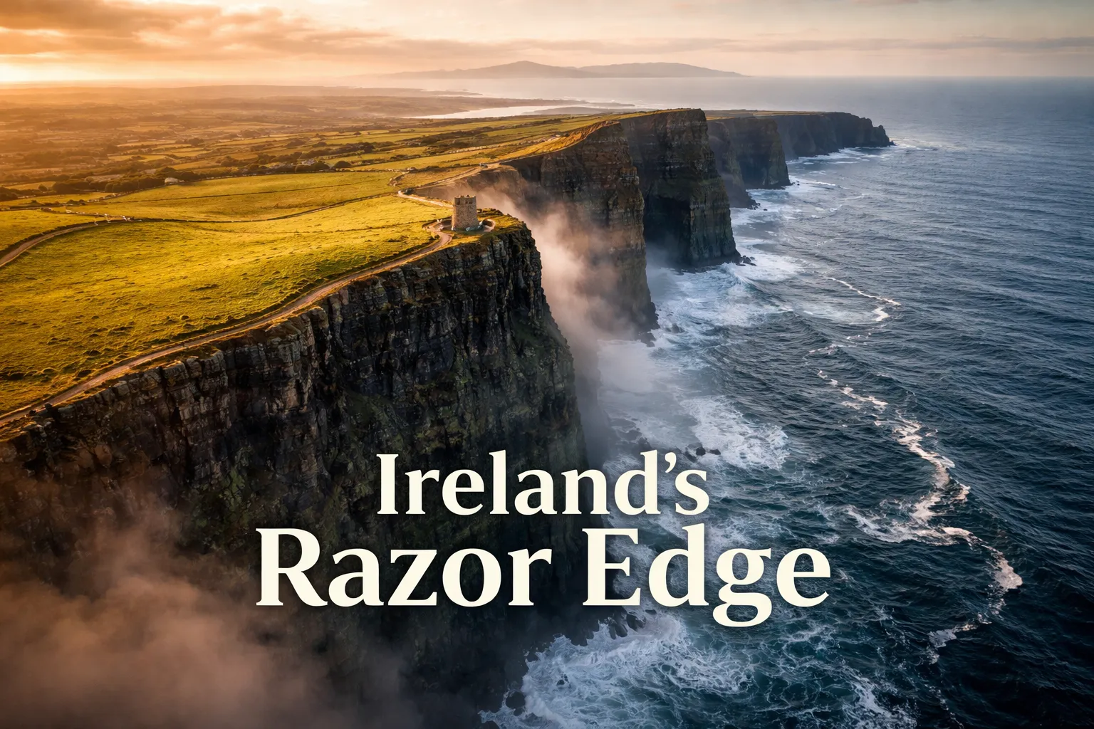
Lean against the wall at the visitor centre and you get the cliff profile stretching left and right — impressive enough that it pulls in over 1.5 million visitors a year. But that ground-level vantage structurally hides something the aerial view of the Cliffs of Moher hands you instantly: the true shape of the edge itself. From up high, the cliff top reads as an unmistakable razor line — green farmland shoves right up against a sheer drop on one side, and on the other, nothing but grey-green Atlantic reaching toward North America. The contrast borders on violent in how clean it is.
Push your cliffs of moher aerial view drone up to roughly 100 metres and several things click into place at once. The full 14-kilometre run of the cliff system finally makes sense — you can watch it bend south toward Hag’s Head and register that you’re looking at one of Europe’s defining coastal edges in a single frame. O’Brien’s Tower, which reads as substantial from the ground, suddenly shrinks into something small and precarious, teetering absurdly close to the drop. The wave action below — invisible entirely from the clifftop — shows up as white detonations against the rock, the same Atlantic swell that’s been hammering that stone for millennia. On a clear morning, the Aran Islands appear on the western horizon like limestone apparitions floating in the bay. These are the frames that make the whole trip worth it.
One thing that caught me off guard from altitude: the seabird ledges. The cliff faces aren’t smooth surfaces — they’re stacked in horizontal shelves that shelter tens of thousands of razorbills, guillemots, and puffins through the breeding season. Straight overhead, those ledges register as little more than faint horizontal streaks in the rock, but shoot a profile angle correctly and the birds themselves show up as texture across the cliff wall. It’s one of the rare places where a single drone frame doubles as a wildlife shot, a geology lesson, and a landscape image all at once.
Shots Worth Chasing: Framing Ideas for Cliffs of Moher Drone Photography in Ireland
Tracing the Razor Edge in Profile
Push the drone out to 80–100 metres altitude, about 150 metres offshore from the cliff edge, then aim back at the coast with the nose tilted slightly upward. This angle exposes the geological banding in remarkable detail — the alternating Namurian shale and sandstone stripes running horizontally across the rock like a compressed timeline of Earth’s history. Low morning sun from the east is the light you want here; it rakes across the cliff face and throws every layer into sharp relief. Shoot 16:9 or 4:3 and leave breathing room at the top of the frame for that strip of green pasture — the tension between farmed land and exposed geology is really the entire story this landscape is telling.
The Straight-Down Frame That Triggers Vertigo
This is the frame that stops the scroll. Hover the drone directly above the cliff edge at 40–60 metres, camera pointed straight down at 90 degrees. Below, the rock face falls away and the Atlantic sits as a dark void at the bottom of the frame. Clifftop grass fills half the composition, the vertical rock wall splits it, and the sea — impossibly far down — closes out the shot. Overcast bright conditions work best here, since diffuse light kills the harsh shadows on the rock and lets the sea surface show its full texture without glare. One warning: this shot demands a steady hand and dead-calm wind — any lateral drift at this altitude, right over the edge, turns into a real equipment and safety problem fast.
O’Brien’s Tower Set Against the Aran Islands
Climb to 120 metres, position yourself southeast of O’Brien’s Tower, then shoot northwest at roughly a 35mm equivalent focal length or wider. The tower sits lower-centre in the frame, the cliff edge cuts diagonally across it, and on a clear morning — visibility can hit 40+ km in that clean Atlantic air — all three Aran Islands (Inis Mór, Inis Meáin, Inis Oírr) show up as dark shapes across Galway Bay on the horizon. This composition tells the full geographic story of the place: you’re standing at the far western edge of continental Europe, staring into open ocean for thousands of kilometres. Golden-hour light from the east, backlit against a pale sky, makes this one of the images your whole portfolio can hang on.
Hag’s Head: Where the Crowds Disappear
Hag’s Head, marking the southern end of the cliff system, is where I’d point any serious aerial shooter first. The headland here is rougher, far less managed, and the ruins of Moher Tower sit on the promontory with a striking geometric presence when seen from above. The cliff angles at this end also allow for longer telephoto compressions of the rock layers that the busier central stretch just doesn’t offer. You get there via a farm track off the R478 near Liscannor — park considerately and walk out to the headland. The crowds here are a fraction of what you’ll find at the visitor centre, and the IAA airspace rules are exactly the same. For anyone chasing ireland drone photography coastal cliffs, this is the overlooked location most guides skip entirely.
Drone Rules at the Cliffs of Moher: Sorting Legal Reality From Assumption
Here’s the honest answer: drone flying at the Cliffs of Moher is legal under Irish aviation law, but it comes with real restrictions you need to understand before you ever land in Clare. Ireland’s aviation authority, the IAA, regulates drones through the EU Open Category system. Most consumer drones under 250g — think the DJI Mini line — fall under Open Category A1, meaning you can often fly without specific operator registration. Drones weighing 250g–900g land under A1/A3 subcategories, which do require registration. And regardless of category, if you’re flying a registered-class drone you need to be registered with the IAA yourself, and you’ll need a valid EU remote pilot competency certificate matching your drone’s class.
The site-specific picture is more layered than the general rules suggest. The Cliffs of Moher sit within a UNESCO Global Geopark and are managed by Clare County Council as a formal visitor attraction. Site management runs its own drone policy on top of national law — commercial operations need advance written permission, and recreational flight near the cliff edge is actively discouraged given crowd density and safety concerns. Get in touch with the Cliffs of Moher Visitor Experience directly before you fly anything. And the broader wild atlantic way drone spots, the Cliffs included, carry seasonal restrictions too: from roughly March through August, low-altitude flight along the cliff face runs into nesting seabirds on those ledges. Disturbing nesting razorbills and guillemots is a legitimate concern, not a technicality, and any photographer with a conscience gives the birds room during breeding season.
Now the wind, because it matters more than any regulation: Ireland’s west coast is, statistically, among the windiest stretches of coastline in Europe. Wind speeds along the cliff edge regularly climb past 30–40 km/h by mid-morning, and the thermal behavior where cliff meets void is genuinely erratic. Atlantic gusts slamming into that vertical rock face create serious updrafts — I’ve had a drone pitch 30 degrees nose-down fighting a gust that materialised within seconds of what looked like a calm window. Your best shot at a clean flight window at the Cliffs of Moher is 05:30–08:00 through June and early July, once overnight pressure systems have settled somewhat and the sea breeze hasn’t kicked in yet. Pull up Windy.com specifically for the Cliffs of Moher coordinates — the local micro-weather diverges sharply from the general County Clare forecast.
Past the Cliffs: Flying the Wider Wild Atlantic Way
The Cliffs of Moher anchor the trip, but the stretch of Wild Atlantic Way between Loop Head in County Clare and Dog’s Bay in Connemara might be the strongest coastal drone route anywhere in the British Isles. From the cliffs, head north on the R478 toward Doolin, then into the Burren — the limestone pavement there looks, from above, like a cracked desert floor colliding with the sea, almost Martian in appearance. Keep going north to the Aran Islands (ferry from Doolin), where the clifftop fort of Dún Aonghasa on Inis Mór is extraordinary from altitude — an Iron Age fortress perched on a 100-metre cliff with nothing but ocean to the west. Further north through Connemara, the lakes, blanket bog, and white-sand beaches around Renvyle and Dog’s Bay give you entirely different aerial palettes to work with. Budget at least four days if you want to do this route justice with drone gear in tow.
Why Spare Propellers Never Leave My Bag at Moher
The Cliffs of Moher aren’t just dramatic to look at — they’re exposed, gusty, and unforgiving toward pilot error. I found out the hard way that one bad gust or one poorly timed maneuver near that edge can snap a prop in an instant, and if you don’t have a spare on you, that’s your shoot over for the day.
What holds up
- The dark grey and orange colouring stands out clearly against grass if a prop comes loose mid-flight — a real advantage when you’re shooting near a cliff edge and can’t afford to lose track of a dropped piece.
- Getting a set of four means you can swap a damaged rotor and stay airborne instead of waiting on a replacement order — this is what saved my three-day trip to Moher when the weather windows kept slamming shut.
- Swapping them takes under a minute, so you’re not stuck fumbling with tools in an Atlantic gale while a small crowd of tourists watches you scramble.
Where it falls short
- They’re built for one drone model specifically (F7GIM compatibility), so they’re useless as backups if you’re rotating between different drones — you’ll need to buy the matching set for whatever you actually fly.
- Backups or not, the plastic edges still take damage on impact, so one rough landing can just as easily wipe out your entire spare set as your original one.
I almost didn’t pack a second set on my last Moher trip, convinced the wind wouldn’t be bad enough to matter—until I felt a hard yaw at 60 metres and heard the mechanical stutter that meant a prop was cracked. Bwine Drone Original Propellers for F7GIM — 4 Pcs Dark Grey & Orange
Frequently Asked Questions
Do I need permission to fly a drone at the Cliffs of Moher?
Yes. The Cliffs of Moher is a designated UNESCO Global Geopark managed by Clare County Council, and formal site operator permission is required. Contact the Cliffs of Moher Visitor Experience before flying. Commercial operations need advance written permission, and recreational flight near the cliff edge is actively discouraged due to crowd density and safety concerns.
What is the best time of day to photograph the Cliffs of Moher by drone?
The best time is 05:30–08:00, from golden hour to mid-morning before sea winds build. This window provides the calmest conditions and best light. Wind speeds regularly climb past 30–40 km/h by mid-morning, and Atlantic gusts create unpredictable updrafts, so early morning is essential for safe flying.
Are there seabird nesting restrictions for drone flying at Moher?
Yes. From roughly March through August, low-altitude flight along the cliff face is restricted due to nesting razorbills, guillemots, and puffins on the cliff ledges. Disturbing these nesting seabirds during breeding season is a legitimate concern that photographers should respect.
What altitude should I fly at to photograph the Cliffs of Moher?
Use 50–120 meters above ground level for cliff-face profiles and geological detail, or 30–60 meters for top-down vertigo shots directly over the edge. Around 100 meters lets you see the full 14-kilometre run of the cliff system and the Aran Islands on the western horizon in a single frame.
About This Article

Written by Elena Vasquez. Elena Vasquez is a full-time traveler and the founder of Witty Passport. Over fifteen years and more than 50 countries across six continents — including a stretch spent leading groups professionally through Southeast Asia and the remote highlands of South America — she's written the kind of destination guides she always wished existed: practical, specific, and built on real experience rather than recycled itineraries. More about this site.
Scope and limits. Elena is a full-time traveler, not a licensed travel agent or immigration adviser. Entry requirements, visa rules, and advisories change without notice — always confirm against the official government source for your destination and passport before booking.
Verify this against a primary source
Specifics change, and your situation may differ from the one described here. These are the authorities worth checking directly:
- U.S. Department of State — entry requirements and travel advisories
- CDC Travelers' Health — vaccination and health notices by destination
- TSA — current carry-on and screening rules