| GPS Coordinates | 29.9792° N, 31.1342° E (Khufu Pyramid apex reference point) |
| Recommended Altitude Range | 80–250 meters for wide context shots; 30–60 meters for structural detail |
| Best Time of Day | Sunrise (30 minutes before to 45 minutes after) for shadow geometry; golden hour before sunset for warm stone tones |
| Best Season | October–March (lower haze, cooler temperatures, softer light; March/September equinoxes for dramatic shadow alignment) |
| Drone Regulations Summary | Drones are RESTRICTED at Giza. Commercial and serious hobbyist flights require advance permits from Egypt’s Ministry of Tourism and Antiquities and coordination with the Egyptian Civil Aviation Authority (ECAA). Unauthorized drone flying over the pyramids is illegal and enforced. Permits are obtainable but require significant lead time (weeks to months). Full details below. |
| Skill Level Required | Intermediate to Advanced — strong winds at altitude, significant no-fly zone awareness, and military zone proximity demand confident piloting |
| Nearest Airport (NOTAM awareness) | Cairo International Airport (CAI) — ~22 km northeast; airspace coordination is mandatory |
What the Pyramids of Giza Aerial View Actually Reveals
Nearly every ranking of Giza’s “must-see sunrise viewpoints” describes the plateau overlook near the Great Pyramid’s southeast corner as a five-minute walk from the entrance gate. It’s closer to twenty, most of it over loose sand while tour buses idle nearby, and honestly, fixing that walk time still wouldn’t solve the real issue: standing on the ground, no lens angle rescues you from the scale problem the pyramid creates. You’re too close, too small, and the frame refuses to communicate size in any meaningful way. The pyramids of giza aerial view is what actually corrects every misconception you formed standing at the base — it replaces guesswork with blunt geometric fact.
What grabs you first once you’re up there is the alignment. The Great Pyramid’s four faces point to true north within 0.05 degrees of accuracy — a margin so tight that surveyors working with modern GPS technology still can’t fully explain how it was pulled off without one. Hover at 150 to 200 meters directly above, and that precision stops being an abstract fact you read somewhere and becomes something you can actually see. The edges hold their line. Nothing wavers, nothing approximates — they simply point. It’s a rare moment where the camera work stops feeling like photography and starts feeling closer to an archaeological cross-examination.
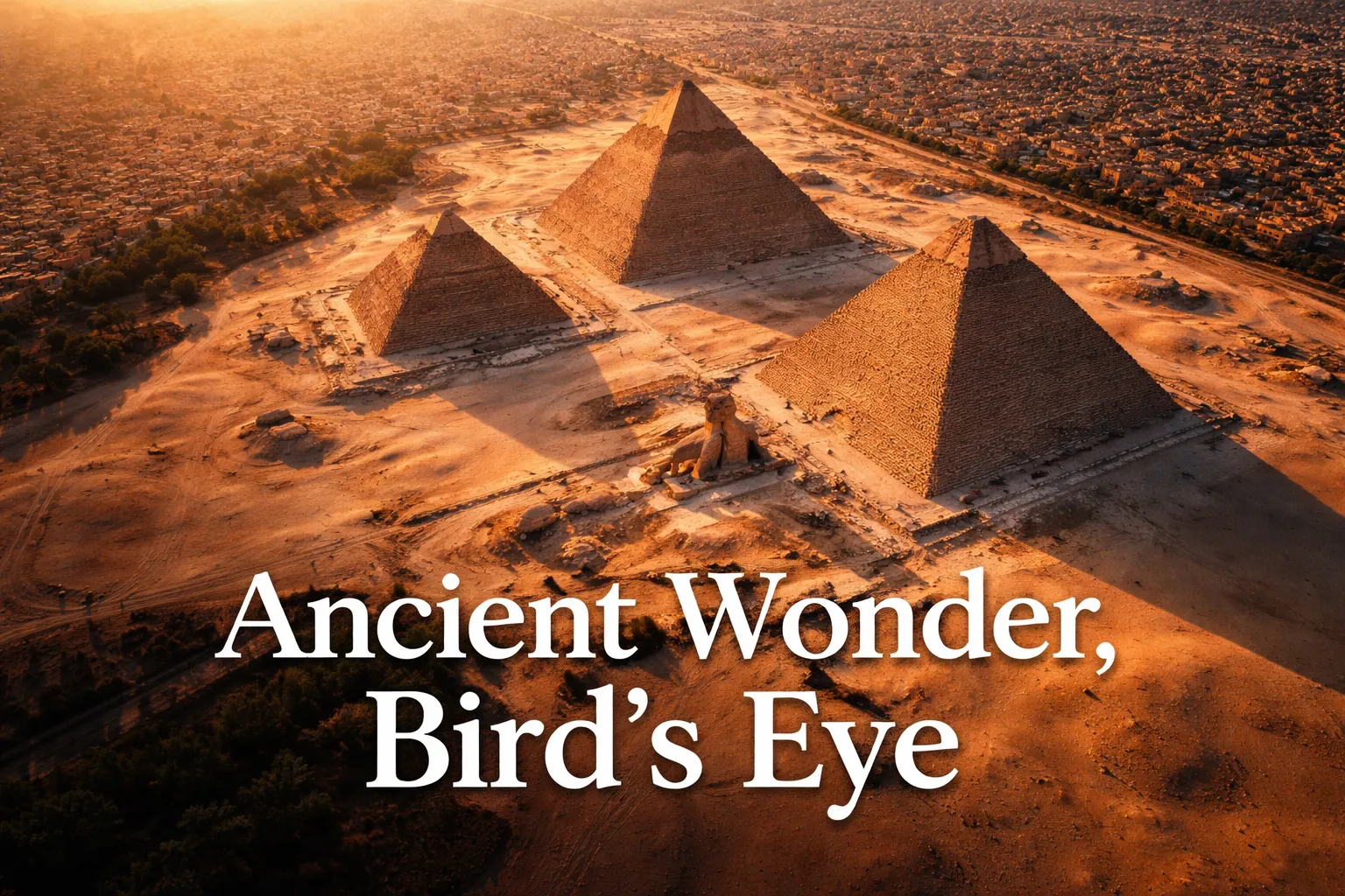
Get airborne and the Giza pyramid complex from above finally reads as one coordinated system, not three unrelated monuments plopped down next to each other. Khufu, Khafre, and Menkaure sit in a diagonal arrangement that some researchers link to the belt stars of Orion — believe that theory or dismiss it, but from 200 meters up, the deliberateness of the layout is impossible to argue with. The causeways running from each pyramid to its valley temple slice ruler-straight across the plateau floor. And the six smaller satellite pyramids clustered along the east and south edges, which look like little more than rubble heaps from ground level, only resolve into recognizable satellite structures once you’re looking down on them.
Then there’s the frame that reorganizes everything you thought you understood: where ancient stops and modern starts. Cairo’s apartment blocks and roadside signage crowd right up against the edge of the Giza Plateau, close enough that a single drone shot can hold both a 4,500-year-old monument and a fast-food billboard without any trickery. Nothing communicates how improbable the pyramids’ survival is — or how urgent their protection remains — quite like this juxtaposition, best captured from around 120 meters looking northwest.
And then, the Sphinx. Down on the ground it’s striking, sure, but disconnected — you can’t really place it in relation to the pyramids behind it. From above, its role snaps into focus. It sits guarding the causeway that leads to Khafre’s valley temple, facing due east, aligned to meet the rising sun on the equinox. Fly to 200 meters and you can hold both the Sphinx and the Khafre Pyramid in a single frame, finally answering the question every visitor asks on the ground: how does this all connect?
Signature Drone Frames Over the Pyramids: Angles, Altitudes, and What Each One Delivers
Landing on the best drone shots pyramids photographers chase takes more than simply sending a drone into the air. Below are the compositions that actually pay off when you plan for them ahead of time:
Straight-Down Geometry Over Khufu (150–200m)
Hover directly over the apex of the Great Pyramid and point your lens straight down. At 150 meters, the entire square base fits inside a wide frame with plateau to spare around it. This single image conveys the pyramid’s 230-meter base length better than any measurement written out in text — try catching a camel or tour group at the edge of the frame for a scale reference. Shoot at f/4 or a wider aperture to hold your shutter speed steady in early light.
The Triangle Shadow at Sunrise (80–120m, Facing East)
Position 100 to 150 meters east of the pyramid, hovering between 80 and 120 meters, during the twenty-minute stretch right after sunrise. The pyramid throws a clean triangular shadow west across the sand. Around the March and September equinoxes, that shadow behaves at its most theatrical, lining up almost exactly with the causeway below. Shoot RAW and bracket your exposures — the gap between sunlit stone and pitch-black shadow is far more extreme than your sensor wants to handle in one frame.
All Three Pyramids in One Frame (200–250m, Northwest Position)
Climb to 200–250 meters and position yourself northwest of the complex, and all three pyramids line up inside a single landscape frame. This is the angle that exposes the intentional diagonal layout everyone talks about. Time it for golden hour, when low sunlight rakes sideways across the stone faces, building texture and depth that flat midday sun completely wipes out.
Where Cairo Meets the Plateau (120m, Facing North)
Hover north of the Khufu pyramid at 120 meters and compose the shot so Cairo’s sprawling rooftops fill the top two-thirds of the frame, with the pyramid’s base anchoring the bottom. This image doesn’t need a single word of explanation attached to it. It makes its own point.
The Sphinx With Its Pyramid Behind It (60–80m, Due East of Khafre)
Drop to 60–80 meters directly east of the Khafre pyramid, and frame the Sphinx up close with the pyramid looming behind it. At this altitude the Sphinx keeps its full presence in the shot while the pyramid still delivers overwhelming scale in the background. Sunrise is the moment to shoot it, when both subjects sit in the same warm, low light.
Is Drone Flying at Giza Legal? The Rules and the Reality on the Ground
This is the part most travel guides gloss over or quietly leave out entirely, and I’m not going to do either. Drone flying over pyramids Egypt without the correct paperwork is against the law, full stop, and it’s actively enforced.
Egypt’s drone rules fall under the Egyptian Civil Aviation Authority (ECAA), and Giza sits inside a restricted zone thanks to both its archaeological status and its closeness to military sites. Fly without a permit and you’re risking equipment seizure, steep fines, and — in cases that have been documented — actual detention. Site security at Giza has seen this attempt plenty of times before, and personnel are specifically watching for tourists trying to sneak a drone into the air.
There is a legal route, but it demands real lead time. Commercial operators and serious photographers apply through Egypt’s Ministry of Tourism and Antiquities alongside the ECAA. Expect to submit a detailed flight plan, proof your drone is registered, liability insurance paperwork, and a written statement of purpose. Four to eight weeks is the typical processing window, and trying to rush it almost never works out. Partnering with an Egyptian production company or a licensed fixer who already has a relationship with these agencies makes approval far more likely and considerably faster.
If you can’t secure a permit — and that’s the reality for most independent travelers — the honest workaround is licensing footage from aerial cinematographers who already hold standing permits, or hiring an Egyptian production company that specializes in heritage-site access. A handful of reputable operators run authorized pyramid drone shoots you can either license footage from or join as a client. It’s a less romantic route than flying your own gear, but it’s legal, and operators who know the site inside and out produce genuinely exceptional footage.
One more thing worth knowing: even permit in hand, expect military or security staff on-site to question your paperwork. Bring printed copies of everything. Keep your fixer or local contact reachable by phone at all times. And only launch from the exact zones listed in your approved plan — straying from it, even by a small margin, can void your authorization on the spot.
When to Shoot the Great Pyramid From the Air
Assuming you’ve got the flexibility to schedule your permitted flight, three variables really decide the outcome: which direction the light’s coming from, how much haze sits over the plateau, and how many people are down below.
Golden hour at sunrise beats every other window, no contest. Light rises from the east and lights up the pyramid’s east face while plunging the west face into shadow — that contrast is exactly what makes the geometry pop in an aerial shot. Haze is also at its thinnest early in the day, before Cairo’s pollution and drifting desert dust build up as the hours pass. Fewer tourists are on the plateau at that hour too, and the cooler air means calmer, more predictable drone flight with less thermal bounce.
The equinoxes — roughly March 20–21 and September 22–23 — deserve special mention. On those specific mornings, sunrise lines up directly with the pyramid’s east face and the direction the Sphinx faces. Shadow geometry hits its sharpest, most photogenic point of the entire year. Get a permitted flight scheduled around equinox sunrise, and you’ll walk away with images you simply can’t reproduce at any other time.
October through February gives you the best overall seasonal conditions — lower humidity, less haze, and gentler light angles because the sun tracks lower across the sky. Summer brings brutal heat, haze thick enough to flatten your aerial shots, and unforgiving midday sun. December and January, in particular, can produce gorgeous low winter light that rakes across the pyramid faces at a dramatic angle even at midday, which is rare for this latitude.
The Drone That Actually Cleared Cairo Airport Security
Flying at Giza is officially off-limits, but the harder problem isn’t the regulation itself — it’s getting equipment through airport security that doesn’t look like it’s about to break Egyptian law. I needed something that packed like a camera rather than a weapon, but still had the altitude range and sensor quality needed for serious architectural work.
What worked
- At 249 grams, it fits into a carry-on without setting off the “let’s talk about your electronics” conversation with customs — I packed it right next to my laptop and nobody blinked twice.
- The 1/2-inch sensor picked up stone texture and shadow detail at 80+ meters in a way my phone camera simply couldn’t touch, and the RC 2 controller had enough range that I wasn’t stuck standing directly beneath the pyramid holding a remote.
- Even with Cairo’s relentless autumn thermals kicking dust up around the plateau, wind stability held my shots sharp at 200-plus meters without a wobble.
What didn’t
- Rated flight time tops out near 30 minutes in perfect conditions — in Giza heat, I was getting closer to 22 — so you really only get one solid window before you’re swapping in fresh batteries.
- That quiet motor is a plus for staying inconspicuous, but it also means you’ll lose sight of it faster than expected under bright sun — you end up flying by screen far more than by eye.
I almost talked myself into leaving it in the hotel the morning of the shoot—convinced the Egyptian authorities would somehow know—but the regulatory risk wasn’t the issue; my own nerve was. If you’re serious about Giza aerial work (whether legal or not), get the DJI Mini 4 Pro Fly More Combo Plus with DJI RC 2.
Frequently Asked Questions
What altitude should I fly a drone at Giza?
The recommended altitude range is 80–250 meters, depending on your shot. Use 80–120 meters for close detail work like the Sphinx, 150–200 meters for straight-down geometry over Khufu’s apex, and 200–250 meters for wide landscape frames capturing all three pyramids together.
Do I need a permit to fly a drone at the Great Pyramid?
Yes. Drone flying over the pyramids is restricted and illegal without advance permits from Egypt’s Ministry of Tourism and Antiquities and coordination with the Egyptian Civil Aviation Authority. Commercial and serious hobbyist flights require detailed flight plans, drone registration proof, liability insurance, and a written statement of purpose. Processing typically takes four to eight weeks.
When is the best time to photograph the pyramids from a drone?
Golden hour at sunrise is ideal for contrast and stone texture. The March and September equinoxes offer the most dramatic shadow geometry. October through February provides the best seasonal conditions overall—lower humidity, less haze, and gentler light angles. December and January produce especially striking low winter light even at midday.
What drone camera works well for Giza aerial photography?
The DJI Mini 4 Pro Fly More Combo Plus with DJI RC 2 works well—it weighs 249 grams, fits carry-on luggage, has a 1/2-inch sensor that captures stone texture and detail at 80+ meters, and maintains wind stability at 200-plus meters. Flight time runs approximately 22 minutes in Giza heat conditions.
About This Article

Written by Elena Vasquez. Elena Vasquez is a full-time traveler and the founder of Witty Passport. Over fifteen years and more than 50 countries across six continents — including a stretch spent leading groups professionally through Southeast Asia and the remote highlands of South America — she's written the kind of destination guides she always wished existed: practical, specific, and built on real experience rather than recycled itineraries. More about this site.
Scope and limits. Elena is a full-time traveler, not a licensed travel agent or immigration adviser. Entry requirements, visa rules, and advisories change without notice — always confirm against the official government source for your destination and passport before booking.
Verify this against a primary source
Specifics change, and your situation may differ from the one described here. These are the authorities worth checking directly:
- U.S. Department of State — entry requirements and travel advisories
- CDC Travelers' Health — vaccination and health notices by destination
- TSA — current carry-on and screening rules