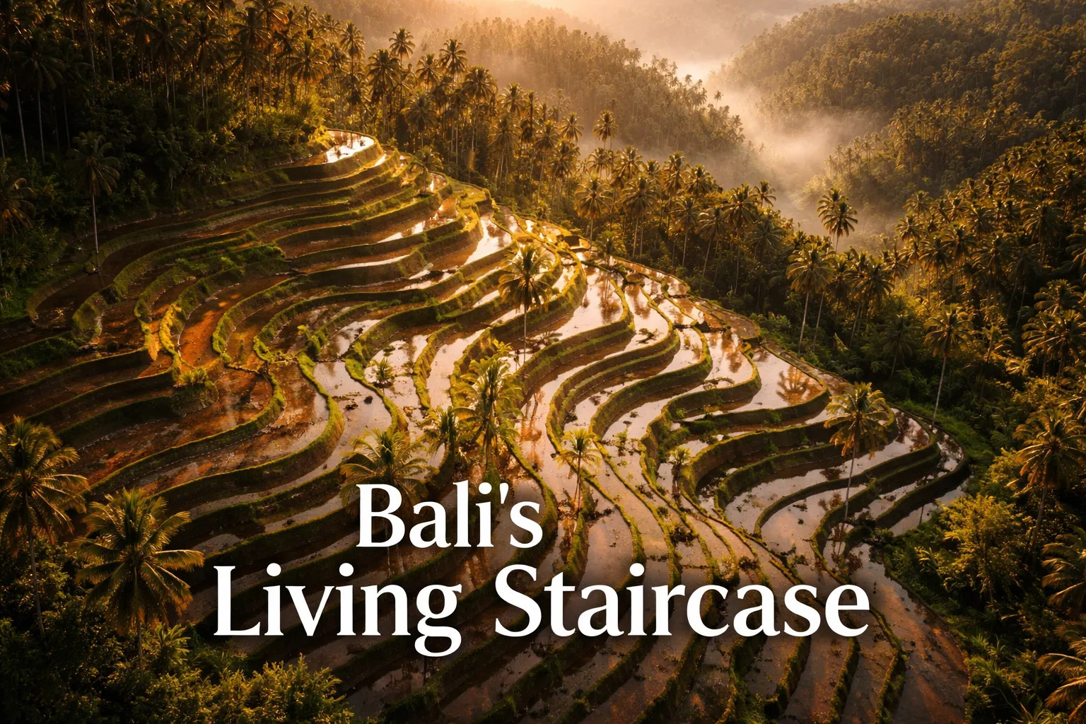
Most people assume that walking the ridge trail at Tegallalang, pausing at the viewing platforms, and snapping the requisite ground-level photo means they’ve actually seen the rice terraces. They haven’t — not really. I made that same assumption myself until the day I sent a drone up over the valley and felt my breath catch. From roughly 80 meters, the whole landscape stops looking like farmland and starts looking like something a giant pressed into the hillside with a thumbprint — thousands of curved, concentric steps tracing the volcanic contours, each one either a thin green ribbon or a sheet of reflected sky, spilling down from the forest line all the way to the valley bottom. I just hovered there for a second, stunned. Then I got to work flying.
Bali’s terraced landscapes — Tegallalang in Gianyar Regency and Jatiluwih over in Tabanan — hold UNESCO cultural-landscape status, and honestly, the view from above is the only version that actually explains why. These fields are fed by the subak cooperative irrigation network, a system that’s been running for more than a thousand years, and once you’re airborne you can watch it function in real time: water moving down from hilltop temples through a gravity-driven maze of channels and weirs, reaching every single terrace in order before it ever spills into the valley below. None of that logic is visible from ground level. From a drone, it looks like a map of something sacred.
Drone Flight Brief: Rice Terraces Bali Aerial Photography at a Glance
| Detail | Tegallalang | Jatiluwih |
|---|---|---|
| GPS Coordinates | -8.4316° S, 115.2781° E | -8.3753° S, 115.0939° E |
| Recommended Altitude | 60–120m (valley width limits higher shots) | 100–200m (open panoramic terrain) |
| Best Time of Day | 6:30–8:30 AM (golden hour, minimal crowd noise) | 6:00–8:00 AM or 4:30–6:00 PM |
| Best Season | Nov–Mar (flooded, mirror reflections) | Apr–Aug (lush green growth, clear skies) |
| Drone Regulations | Registration required via DitJenHubud; fly under 120m; no flight over crowds or ceremonies | Same national rules apply; fewer crowds, easier compliance |
| Skill Level | Intermediate (tight valley, thermal winds) | Beginner–Intermediate (open terrain, more forgiving) |
| Permit Required? | National registration only — no site-specific permit as of 2024 | National registration only |
Reading the Subak System From the Air
Stand on Tegallalang’s main ridge road and you see terraces. Descend into the valley and you feel them underfoot. But climb to 100 meters and, for the first time, you actually understand them. The subak water-sharing system — the reason UNESCO listed this landscape in 2012 under the “Cultural Landscape of Bali Province” designation — is essentially a network of communal water rights structured around temple hierarchy. Airborne, you can follow the main channel as it drops down from the Pura Masceti temple complex, splitting into smaller feeder lines that deliver each farmer’s share in strict sequence. It’s cooperative engineering that predates modern infrastructure by ten centuries, and altitude is the only vantage point where its logic becomes readable.
During the flooded planting window from November through March, the tegallalang rice terraces aerial view turns into something close to surreal. Every flooded plot works like a shallow mirror, so from above you’re looking at a staircase of reflected sky climbing the hill — silvery, pale-blue steps interrupted by patches of dark green where nearby farmers are further along in their growth cycle. That staggering isn’t accidental: the subak network deliberately offsets planting schedules on adjoining plots to disrupt pest cycles, a traditional pest-management strategy a Stanford University study flagged as among the most sophisticated agricultural systems anywhere on the planet. From 80 meters, you catch the entire patchwork of growth stages in one glance — a view no farmer walking the paths between plots could ever piece together on foot.
Jatiluwih sits at around 700 meters on the southern flank of Mount Batukaru, and the aerial view here is a completely different animal. The terraces stretch wider, the steps are broader and gentler, and the volcano looms behind them in a way that only makes sense from a drone parked at 150–200 meters. On a clear morning before 8 AM, you can frame Batukaru’s dark, forested slopes against terraces still lit by low sunrise angles, with mist pooling in the valley beneath. There’s no ground shot that compresses volcano, ancient terrace, and low-hanging cloud into one frame the way this does.
Rice Terraces Bali Drone Photography: The Shots Worth Capturing
Tegallalang’s Valley Curve — 70–90m, Straight Down or 45°
Tegallalang’s signature image is a near-vertical shot (or a 70–80° angle) taken from around 80 meters, hovering over the center of the valley where the terrace curves are at their most dramatic on either side. It’s the composition that turns the landscape into a living topographic map. Fly it during the flooded months (November–March) and you get concentric rings of mirrored water. Fly it during growing season (April–August) and the green turns almost neon against the red-brown dirt paths threading between plots. Position yourself around 50 meters south of the main viewing bridge and launch early, before the vendors and tour groups arrive.
Framing With the Coconut Palms — 40–60m, Low Sweep
The coconut palms scattered through Tegallalang make decent foreground props from the ground, but from a drone at 40–60 meters they become something far more useful. Flying just above canopy height, the palms turn into natural frames — their feathery crowns sitting in the foreground while the terrace layers stack up behind them. A slow lateral pass at this altitude, tracking parallel to the valley slope, produces one of the most cinematic sequences available here. Keep the gimbal tilted around 60–70° so you hold both the palm tops and enough terrace context in frame. Early morning is best, when the low sun catches individual fronds and gives the canopy real texture.
Jatiluwih’s Panoramic With Batukaru — 150–200m, 30–45° Tilt
For the definitive Jatiluwih rice terraces from above shot, climb to 150–200 meters with the gimbal angled 30–45° downward, placing Mount Batukaru centered or slightly off-axis in the top third of the frame. Launch near the parking area at the western end of the UNESCO scenic road — the airspace there is unobstructed over the terraces and keeps you clear of the handful of small temples along the route. This is a wide, horizontal composition: terraces fill the lower two-thirds in stacked lines, and the mountain supplies the vertical punch behind them. During dry season, when clouds cap Batukaru’s peak, the resulting frame looks almost fabricated, like a rendering rather than a photo.
Is Drone Flying Legal at Bali’s Rice Terraces? Indonesia’s Regulations Explained
The short version, for most traveling photographers: yes — Bali is genuinely accommodating toward drones by regional standards, provided you prepare properly. Indonesia’s rules fall under the Directorate General of Civil Aviation (DitJenHubud), governed by Ministry of Transportation Regulation PM 37 of 2020. Here’s what actually applies to travel photography over the rice terraces:
- Altitude ceiling: 120 meters above ground level in uncontrolled airspace
- Registration: Any drone over 250g must be registered through DitJenHubud’s online portal before it flies. It’s simple enough for visitors — the whole process happens online, takes about 30 minutes, and costs a small fee.
- Sub-250g drones (think DJI Mini 4 Pro or Mini 5 Pro) go through a lighter registration process with fewer operating restrictions overall — a real advantage once you’re actually out flying.
- Restricted airspace: Ngurah Rai airport carries a 5km controlled zone. As of 2024, neither Tegallalang nor Jatiluwih sits inside any published no-fly area — but double-check with the AirVisual or Drone Deploy apps before every single flight anyway.
- The unwritten rule: No app will tell you this one. Never launch during, or hover over, an active temple ceremony or religious procession. It’s disrespectful, it creates genuine friction with the community, and local authorities are within their rights to shut you down on the spot. I always check ceremony schedules with a nearby warung owner or farmer before I set up.
The on-the-ground reality, for anyone using this as a Bali drone photography guide: Tegallalang collects a small local fee, usually right at the main viewpoint entrance, and some warung owners near popular launch points have started quietly asking drone operators for a donation — somewhere around Rp 20,000–50,000 is fair and keeps goodwill with the people whose land you’re hovering above. Just pay it. It’s roughly $1–3 USD, and it counts for more than the amount suggests.
When to Photograph Bali’s Rice Terraces From the Air
These two seasons aren’t just different lighting conditions — they’re practically different subjects. November through March, the flooded planting stretch, is when the mirror-terrace effect happens. Farmers flood individual plots ahead of planting, and because the subak system staggers those planting dates across neighboring fields, you end up with a mosaic of silver flooded mirrors sitting right next to vivid green shoots, all in the same frame. Wet-season light tends to be dramatic too — heavy cumulus clouds, sudden shafts of sun — which works well for drone shots as long as you’re prepared to dodge the afternoon downpours and fly during the morning window instead. Worth noting: the humidity does chip away slightly at battery performance.
April through August, the growing and harvest stretch, delivers the saturated green that shows up on every Bali postcard. Terraces at full growth read as a deep, intense green in aerial shots — especially early morning, when low sun throws long shadows across the terrace walls and gives the whole landscape a three-dimensional feel. It’s also the drier season, meaning cleaner air, sharper visibility toward Mount Batukaru at Jatiluwih, and steadier morning conditions overall. If this is your first time attempting this kind of shoot, I’d point you toward this season specifically — the conditions behave predictably and the color is extraordinary.
Whichever season you land in, golden hour isn’t optional. The 90 minutes after sunrise deliver warm, angled light that rakes across the terrace walls and produces the texture that makes aerial terrace photography stand out. Once mid-morning hits, the light goes flat and compositions lose most of their punch. I’ve flown at Tegallalang dozens of times now, and the shots worth keeping almost always come from before 8:30 AM.
The Drone Small Enough for a Bali Day Pack (And Unlikely to Get Confiscated)
Flying over Tegallalang means dealing with Indonesian airspace rules, local sensitivities, and the blunt reality that hauling a phantom-sized aircraft through humid rice villages is a good way to make enemies fast. What I needed was something small enough to disappear into my backpack, capable enough to capture those impossible fingerprint patterns from above, and — this part mattered most — unthreatening enough that locals or officials wouldn’t shut me down before I got a single frame.
What worked
- Genuinely pocket-sized — it rode in my camera bag next to my mirrorless without hogging space or adding weight I noticed on a four-hour valley trek.
- It doesn’t spook people the way larger drones do — I got curious questions from farmers and security staff instead of flat refusals.
- 4K footage shot from 80+ meters shows the subak geometry in remarkable detail — those curved patterns that look abstract on the ground suddenly click into place.
What didn’t
- Valley wind gusts can genuinely wreck footage stability — you either need calm air or you’re trading the shot you wanted for steadier shots you didn’t.
- Battery life is limited — 25 to 30 minutes tops, which feels generous until you’re standing in exactly the right spot with maybe eight minutes of flight time left.
I nearly lost the whole sequence when a sudden updraft caught me off-guard my second morning and the drone drifted closer to the ridge than I’d intended — one wrong correction and it would’ve been a very expensive tumble into the terraces. But the precision controls brought it back, and that’s when I knew I’d made the right call. DJI Mini 4 Pro Fly More Combo Plus with DJI RC 2
Frequently Asked Questions
What altitude should I fly at Tegallalang rice terraces?
Fly between 60–120 meters at Tegallalang, where valley width limits higher shots. For Tegallalang’s signature near-vertical shot capturing the dramatic valley curves, hover around 80 meters. The article recommends 100 meters to understand the subak water system’s full logic from above.
Do I need a permit to fly a drone at Bali rice terraces?
National registration through DitJenHubud is required for any drone over 250g, but neither Tegallalang nor Jatiluwih requires a site-specific permit as of 2024. However, always check AirVisual or Drone Deploy before flying, and never launch during active temple ceremonies or religious processions.
What’s the best time of year for drone photography at Tegallalang?
November through March delivers flooded terraces that reflect sky like mirrors, creating surreal staircase effects. April through August offers saturated green growth and clearer visibility. For first-time flyers, April–August provides more predictable conditions and extraordinary color, but either season requires flying during golden hour before 8:30 AM.
Can I use a DJI Mini 4 Pro at Bali’s rice terraces?
Yes. The DJI Mini 4 Pro Fly More Combo Plus with DJI RC 2 is small enough to carry four hours through rice valley terrain without spooking locals, captures 4K footage showing subak geometry from 80+ meters, and won’t draw unwanted official attention the way larger drones do.
About This Article

Written by Elena Vasquez. Elena Vasquez is a full-time traveler and the founder of Witty Passport. Over fifteen years and more than 50 countries across six continents — including a stretch spent leading groups professionally through Southeast Asia and the remote highlands of South America — she's written the kind of destination guides she always wished existed: practical, specific, and built on real experience rather than recycled itineraries. More about this site.
Scope and limits. Elena is a full-time traveler, not a licensed travel agent or immigration adviser. Entry requirements, visa rules, and advisories change without notice — always confirm against the official government source for your destination and passport before booking.
Verify this against a primary source
Specifics change, and your situation may differ from the one described here. These are the authorities worth checking directly:
- U.S. Department of State — entry requirements and travel advisories
- CDC Travelers' Health — vaccination and health notices by destination
- TSA — current carry-on and screening rules