
This post contains affiliate links. As an Amazon Associate, I earn from qualifying purchases at no extra cost to you.
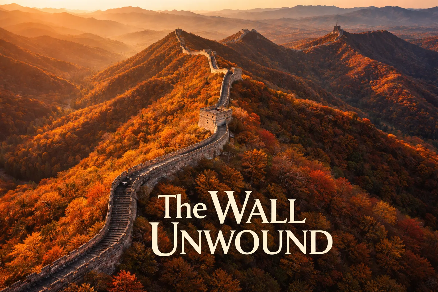
The moment my drone cleared the treeline above Jinshanling and the Great Wall came into full view, I stopped breathing. Nothing — not a single photograph I’d seen, not a documentary, not even standing on the wall itself — had prepared me for what great wall of china drone footage actually looks like from 150 meters up. The wall doesn’t just cross the mountains. It is the mountains. It traces every ridge, dips into every valley, and vanishes into the horizon in both directions like a stone spine stitched into the earth by giants. From the ground, you see a section of wall. From the air, you finally understand what 21,196 kilometers actually means.
Great Wall of China Drone Flight Brief
| Best GPS Coordinates (Jinshanling) | 40.6753° N, 117.2437° E |
| Best GPS Coordinates (Jiankou) | 40.4408° N, 116.4537° E |
| Best GPS Coordinates (Simatai) | 40.6546° N, 117.2747° E |
| Recommended Altitude Range | 80–300m depending on composition (see section below) |
| Best Time of Day | Golden hour (6:00–8:00am) and dusk (5:00–7:00pm, season-dependent) |
| Best Season | Mid-October to early November (autumn foliage peak) |
| Drone Regulations Summary | CAAC registration mandatory; Badaling and Mutianyu are strict no-fly zones; Jinshanling and Jiankou require advance permission; always verify current restrictions before flying |
| Skill Level Required | Advanced — mountain thermals, ridge winds, and permit complexity make this unsuitable for beginners |
| Nearest Major Airport | Beijing Capital International (PEK) — 90–120km depending on section |
What Great Wall Aerial Photography Reveals That Ground Photos Never Can
Standing on the wall, you experience scale through your legs — the relentless climb, the uneven stone, the watchtowers appearing every few hundred meters. But from the air, a completely different truth emerges. The wall’s relationship with topography becomes visible for the first time. You can see how Ming Dynasty engineers used the natural mountain ridgelines as a structural foundation, placing the wall precisely along the sharpest, most defensible crests. From 200 meters up, you can read those strategic decisions like a map.
The second revelation is color contrast. The grey limestone and granite of the wall cuts through vegetation that changes dramatically with season. In October, the wall bisects a sea of burning orange and red — a visual contrast so stark it looks almost artificially enhanced in footage. In winter, the wall emerges from snow-covered slopes in pure black and white geometry. From the ground, you’re inside that color. From a drone, you see the full painting.
The third thing that strikes you — and this is something that never fully registers in any ground photograph — is how thin the wall is relative to the wilderness surrounding it. From altitude, it becomes a single brushstroke across hundreds of kilometers of unbroken mountain forest. The audacity of its construction, the sheer human obsession it represents, lands differently when you can see how small it is against the landscape it was built to divide.
Great Wall from Above: Best Sections for Drone Photography
Jinshanling — The Aerial Photographer’s First Choice
Jinshanling sits approximately 125 kilometers northeast of Beijing and is consistently the most recommended section for great wall aerial photography for several reasons. The wall here runs along a dramatic east-west ridgeline with steep drops on both sides, creating a natural leading line that extends to the horizon in both directions from any elevated perspective. The section is partially restored — meaning the watchtowers are intact enough to be visually striking — but visitor numbers are a fraction of Badaling, so you’re not photographing crowds. The elevation changes are significant, giving your aerial footage natural drama as the wall climbs and descends with the terrain. Permission to fly here requires coordination with local authorities, but it is obtainable, and the results justify every bureaucratic headache.
Jiankou — Wild Wall and Forest Wilderness
Jiankou is the section that serious aerial photographers dream about. Located about 90 kilometers north of Beijing, this stretch of unrestored wall is being slowly reclaimed by dense forest — crumbling watchtowers lean at impossible angles, entire sections have collapsed into rubble, and the stone is carpeted in moss and lichen. From the air, Jiankou looks like an ancient ruin rediscovered rather than a maintained historical site. The “Arrow Nock” section, where the wall turns sharply at a steep ridgeline junction, is one of the most recognizable and photographed aerial compositions in China. This section is technically off-limits to tourists on the ground, which adds a layer of complexity to any aerial shoot, but photographers who have captured legitimate drone flying over great wall china footage here consistently cite it as the most atmospheric section in any season.
Simatai — Reservoir Reflections and Evening Light
Simatai offers something none of the other sections can: water. The Miyun Reservoir sits directly below several stretches of wall here, and at the right altitude and angle, you can capture the wall’s reflection shimmering in still water while the stone structure climbs the cliffs above it. This doubles the visual impact of any aerial composition and creates a symmetry that feels almost surreal. The night wall lighting at Simatai is also famous — the section adjacent to Gubei Water Town is illuminated after dark, and while flying at night carries additional regulatory complexity, the ambient light creates extraordinary long-exposure aerial opportunities for photographers equipped for it. Simatai is one of the few sections with organized tourism infrastructure that has historically been more receptive to coordinated photography permissions.
The Best Shots to Capture: Altitude and Composition Guide
The best altitude for photographing the Great Wall depends entirely on what story you’re trying to tell. Here are the four compositions that define world-class great wall drone footage, with specific altitude recommendations based on field experience:
- The Infinity Shot (250–300m): Pull the drone up to 250–300 meters and point the camera straight down at a 45-degree angle toward the horizon. At this altitude, the wall becomes a single continuous line cutting through the mountain landscape in both directions. Use a telephoto zoom to compress the layers of ridgelines behind the wall. Best executed at Jinshanling where the wall runs unbroken for several kilometers in view.
- The Watchtower Shadow Shot (80–120m): The best altitude for capturing individual watchtower detail with dramatic shadow geometry is 80–120 meters, shot during the first two hours after sunrise. At this height, the low sun casts the watchtower’s crenellated silhouette across the wall rampart below it in long, angular shadows. Position the drone slightly to the east of the tower so the shadow falls toward the camera. This is the shot that defines golden hour Great Wall photography.
- The Fog Immersion Shot (30–60m): On mornings following rain, valley fog rolls through the mountain gaps and partially swallows the wall. The best altitude for capturing the wall emerging from fog is 30–60 meters — low enough that the wall’s surface detail remains sharp while the valleys below disappear into white. This requires arriving before dawn and positioning over a ridge section where fog flows through the gaps between mountains. Jiankou’s dense forest creates the most dramatic fog conditions.
- The Autumn Color Canopy Shot (150–200m): In mid-October, position the drone at 150–200 meters directly above the wall and point the camera straight down at 90 degrees. The wall becomes a grey stone line cutting through a mosaic of red, orange, and gold canopy. This top-down composition works particularly well at Jiankou where the forest growth is densest and the color saturation is highest.
Great Wall Drone Regulations China: What You Actually Need to Know
I’ll be direct with you: flying a drone at the Great Wall of China is legally complicated, actively enforced in some areas, and requires preparation that most tourists don’t anticipate. Here is the honest breakdown of great wall drone regulations China as they currently stand.
CAAC Registration is Mandatory. All drones over 250 grams must be registered with China’s Civil Aviation Administration (CAAC) via the UTMISS system. Foreign visitors are required to register through the official CAAC app or website before flying. This is not optional, and authorities at popular Wall sections actively check for compliance. Register before you leave home — the process requires a Chinese phone number for verification, which adds a logistical layer worth solving in advance via a local SIM or travel contact.
Badaling and Mutianyu are No-Fly Zones — Full Stop. Both of these sections fall within Beijing’s controlled airspace and protected cultural heritage no-fly designations. Flying here is illegal regardless of permit status. Do not attempt it. The consequences include equipment confiscation, significant fines, and potential detention. I have seen photographers lose expensive equipment at these locations. It is not worth it.
Jinshanling, Jiankou, and Simatai Require Advance Permission. These sections are outside Beijing’s immediate restricted airspace but still require coordination with local scenic area authorities and, in some cases, local aviation authorities. The application process is inconsistent and can take weeks. Working through a local fixer or licensed Chinese photography production company significantly improves your chances of obtaining legal authorization. Several professional drone operators based in Beijing specialize in exactly this kind of permitted Great Wall shoot — hiring one for even a single session is a legitimate strategy for accessing the best sections legally.
Practical Reality: Unauthorized drone footage of the Great Wall does exist online, and some photographers have flown without incident in remote sections. I am not recommending this approach. Enforcement is increasing, and the reputational and legal risk to you — and to the broader photography community’s access to these locations — is real. The permitted route is harder but it’s the right one.
Gear Worth Packing for Great Wall Aerial Photography
The mountain ridgelines where the Great Wall sits generate unpredictable thermal winds, especially in the hours after sunrise when cold valley air and warm ridge air collide. You need a drone with the stability and wind resistance to handle these conditions confidently, which is why the DJI Mavic 3 Pro with RC belongs at the top of this kit list. The 4/3 CMOS Hasselblad sensor delivers the color science and dynamic range you need to capture the wall’s grey stone against autumn foliage without blowing out highlights or losing shadow detail in the treeline below — a balance that cheaper sensors consistently fail at this location. The 43-minute flight time means you can execute the slow, deliberate orbit and reveal shots that define great aerial Wall footage without racing the battery. FAA Remote ID compliance also reflects the kind of regulatory-ready engineering philosophy that matters when you’re dealing with CAAC requirements in China. I learned the hard way that a cheaper drone with shorter flight time forces you to rush compositions; the Mavic 3 Pro lets you wait for the light to be exactly right.
If you want to future-proof your kit and capture the Great Wall at the highest possible resolution currently available in a compact consumer drone, the DJI Mavic 4 Pro Fly More Combo with DJI RC 2 is the definitive choice. The 100-megapixel 4/3 CMOS Hasselblad camera means that top-down autumn canopy shot at 150 meters will deliver enough resolution to print at mural scale — every individual leaf, every stone block on the wall surface, rendered in extraordinary detail. The 51-minute maximum flight time is a genuine operational advantage at a location like Jinshanling where you might hike 20 minutes from your launch point and need every minute of air time once you’re there. The 30km video transmission range far exceeds anything you’ll need, but it speaks to the overall signal robustness that matters in mountain terrain where terrain interference can disrupt video feed. The Fly More Combo includes the charging hub, which is critical when you’re operating from a remote location and need to cycle through batteries efficiently during a morning golden hour window.
For photographers who want the Mavic 3 Pro’s proven imaging system with the operational endurance for a full day’s multi-location shoot across different Great Wall sections, the DJI Mavic 3 Pro Fly More Combo with DJI RC is the smartest investment in this kit. Three batteries and the charging hub give you approximately two hours of total flight time, which is enough to shoot Jinshanling at dawn, rest and recharge at a guesthouse, and capture a second session during the late afternoon golden window before the light dies — a two-session day structure that professional Great Wall photographers consistently use to maximize the limited quality light hours. I specifically value this combo for remote Wall sections because charging infrastructure near Jinshanling and Jiankou is limited; having three fully charged batteries loaded before you leave your accommodation eliminates the anxiety of mid-shoot power management. The triple-camera system’s tele compression at 166mm equivalent is also the specific focal length that makes the ridgeline-upon-ridgeline receding wall compositions look so three-dimensional.
Best Time to Photograph the Great Wall From Above
The single best window for great wall aerial photography is the two-week period centered on mid-October — typically October 10th through October 25th — when Beijing’s surrounding mountains hit peak autumn foliage. The combination of orange and red canopy against grey stone under clear post-summer skies creates a color palette that no other season can match. Morning temperatures at ridge elevation drop to near freezing, which suppresses the atmospheric haze that plagues summer shooting and delivers the crisp, high-contrast footage that makes Great Wall drone shots iconic.
Winter — particularly January and February — is the second-best season for a completely different aesthetic. Snow-covered slopes reduce the visual complexity of the landscape and let the wall read as pure bold geometry against white. The air quality in winter is dramatically better than spring or summer. The trade-off is extreme cold at altitude, which significantly reduces battery performance — expect 30–40% reduction in flight time compared to manufacturer specifications and carry hand warmers to keep batteries at operating temperature before launch.
Avoid July and August categorically. Summer haze is severe enough to reduce visibility at altitude to the point where the wall loses its definition against the hazy distance. High humidity also increases sensor noise in challenging lighting conditions. Spring (March–April) offers wildflower coverage at lower elevations but unpredictable wind and lingering haze limit its value for aerial work.
Frequently Asked Questions
Can you fly a drone at the Great Wall of China?
Yes, in certain sections — but with significant legal requirements. Sections like Badaling and Mutianyu fall within Beijing’s restricted airspace and are complete no-fly zones where drone flight is illegal regardless of permit status. Sections further from Beijing, including Jinshanling, Jiankou, and Simatai, are not blanket no-fly zones but require advance permission from local scenic area authorities and CAAC registration via the UTMISS system. All drones over 250 grams must be registered before flying anywhere in China. Working with a local licensed operator is the most reliable way to fly legally at these sections.
What is the best section of the Great Wall for drone footage?
Jinshanling is the best overall section for aerial photography because it combines dramatic ridgeline topography, partially intact watchtowers, relatively low visitor density, and a wall alignment that extends to the horizon in both directions — creating the leading-line compositions that define iconic Great Wall drone footage. Jiankou is the most visually striking section for wild, unrestored atmosphere but carries additional access complexity. Simatai is the best choice for photographers specifically seeking the wall-and-water reservoir reflection compositions.
What altitude should I fly to photograph the Great Wall from a drone?
The best