
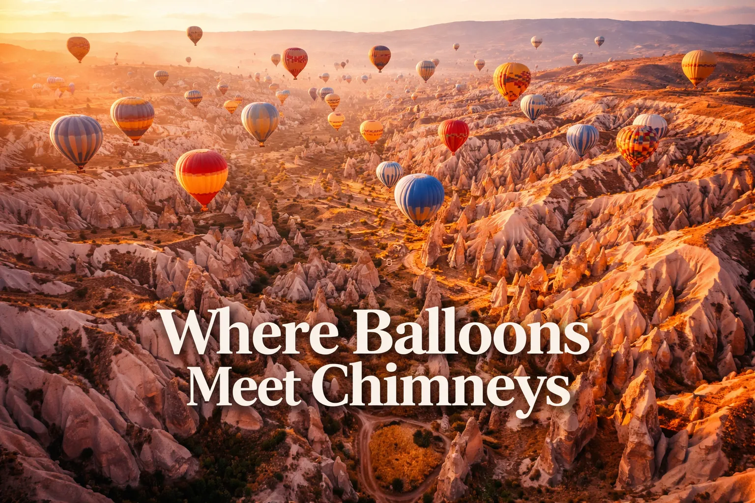
The moment my drone cleared the rooftop of my cave hotel in Göreme and I saw Cappadocia from above for the first time, I genuinely stopped breathing. Below me, rippling out in every direction, was a landscape that looked designed by a fever dream — thousands of pale volcanic spires clustered in valleys, carved cave windows catching the first orange light, and rising silently above all of it, dozens upon dozens of hot air balloons drifting like living confetti. Cappadocia drone photography hot air balloons is a phrase that gets typed into search bars millions of times a year, and I understand exactly why. No photograph taken from the ground prepares you for what this place actually looks like from 120 meters up. This guide is everything I learned across three dawn flights in Cappadocia — the legal realities, the best compositions, the technical challenges of sharing airspace with 150 balloons, and the specific moments that made every early alarm worth it.
Cappadocia Drone Flight Brief
| Primary GPS Coordinates (Göreme) | 38.6431° N, 34.8283° E |
| Rose Valley Launch Point | 38.6697° N, 34.8731° E |
| Love Valley Viewpoint | 38.6744° N, 34.8175° E |
| Recommended Altitude Range | 80–200m (legal ceiling 120m in most zones; fly conservatively) |
| Best Time of Day | Civil twilight to 30 minutes before balloon window opens (~05:30–06:00 local time, seasonal); or post-balloon from 09:00 onward |
| Best Season | April–June and September–November (stable winds, golden light, peak balloon launches) |
| Drone Regulations Summary | Registration with Turkey’s SHGM (Sivil Havacılık Genel Müdürlüğü) mandatory; permit required; flying during active balloon hours in restricted zones is prohibited; No-Fly Zones enforced around active balloon corridors — see full section below |
| Skill Level Required | Advanced — dynamic airspace, unpredictable thermal winds, proximity to balloon traffic |
| Difficulty Rating | ⬛⬛⬛⬛⬜ (4/5) |
What the Cappadocia Aerial View Reveals That You Cannot See From the Ground
Standing in Rose Valley, you see fairy chimneys. From 150 meters above Rose Valley, you see the system — a vast drainage network of ribbed erosion channels radiating outward like a fingerprint pressed into pink tuff, each channel wall studded with carved openings, and the whole geometry only legible from altitude. This is what cappadocia aerial view fairy chimneys photography is really about: revealing the hidden order beneath an apparently chaotic landscape.
Here is what genuinely surprised me from above, and what no ground-level photograph in any travel magazine had shown me:
- The pigeon house cliff faces: From the ground, carved pigeon holes are decorative details. From 100m up and angled slightly downward at 45°, entire cliff faces reveal themselves as dense grids of carved facades — hundreds of openings in geometric patterns that Cappadocian farmers used for centuries to collect pigeon guano as fertilizer. The scale is only visible from altitude.
- Underground city ventilation shafts: Near Derinkuyu and Kaymakli, circular vent openings are barely noticeable at ground level. From 80–100m directly overhead on a clear morning, these shafts resolve as dark circles punched through pale rock — the topographic signature of cities built 18 stories underground. It is one of the strangest things I have photographed.
- Göreme’s human-geology fusion: The town of Göreme looks, from the air, like it was poured into the valleys around the fairy chimneys rather than built alongside them. Cave windows are flush with natural rock faces. Hotel terraces emerge seamlessly from tuff formations. You cannot tell where geology ends and architecture begins, and that ambiguity is only visible at altitude.
- The balloon flotilla geometry: At peak season, up to 150 balloons launch within a 45-minute window. From directly above at 200m — during the legal pre-balloon window — you can photograph the full launch field with baskets clustered on the ground, envelopes inflating, and the first balloons rising while others are still flat. The color geometry against the pink tuff rock is unlike anything else in aerial photography.
Can You Fly a Drone in Cappadocia? Regulations & Practical Reality
This is the section most travel blogs skip or soften. I am going to be direct with you because flying illegally in Cappadocia during balloon operations is genuinely dangerous — not just to your equipment but to human lives in balloon baskets.
Turkey’s SHGM requires the following for legal drone flight: All drones above 500g must be registered with the SHGM before flight. You must obtain a UHA (Unmanned Aircraft) operator certificate. Foreign visitors must apply through SHGM’s online portal before arriving in Turkey — this is not something you can arrange on arrival. Flight is prohibited within active TFRs (Temporary Flight Restrictions), which are issued daily in Cappadocia during balloon operation hours, typically from approximately 05:30 to 08:30 local time, varying by season and wind conditions. The Göreme National Park and surrounding UNESCO-protected zones have specific No-Fly Zone designations that are separate from the balloon TFRs.
The practical reality for most visitors: The drone footage you see all over Instagram captioned “Cappadocia balloons from above” was either shot by licensed commercial operators with specific SHGM permits, or it was shot illegally. I am not here to judge — but I am here to tell you that Turkish aviation authorities have been actively enforcing these rules, fines are significant, and equipment confiscation is a real outcome. The safest legal approach is to fly before the balloon TFR window opens (civil twilight, pre-launch), shoot the landscape without the balloons in frame, and then land well before the restriction kicks in. Alternatively, the post-balloon window from approximately 09:00 onward gives excellent light for valley and chimney photography without airspace conflict.
If you want balloon-and-drone footage: Contact licensed local operators in Göreme — several hold commercial permits that include balloon-hour flight windows. Hiring or partnering with one is the only legal way to capture the iconic flotilla shot from a drone.
Best Drone Spots in Cappadocia, Turkey: Locations & Compositions
After three mornings of pre-dawn alarms and one very cold valley floor, these are the best drone spots Cappadocia Turkey has to offer — ranked by photographic yield and practical accessibility.
Rose Valley (Güllüdere)
The best single location for drone photography Cappadocia Turkey at first light. The valley walls glow deep amber-pink before direct sun arrives, and the erosion channel system reads beautifully at 100–150m altitude with a nadir (straight-down) or 60° angled shot. Launch from the northern trailhead parking area. Fly east-facing for the best warm light. Best altitude for revealing the full valley drainage pattern is 180–200m, though stay within legal limits for your permit class.
Love Valley
The phallic fairy chimneys here are famous at ground level, but from 80m looking down the valley axis, they resolve as a dense forest of columnar formations with a natural vanishing-point perspective that is extraordinary. The trick is a low-altitude (60–80m), slight forward tilt on the gimbal — maybe 30° below horizontal — shooting down the valley length rather than across it. Midday light actually works here because the valley runs roughly north-south and the chimneys cast dramatic shadows on each other.
Göreme Town from the Northeast Ridge
Launch from the plateau northeast of the Open Air Museum and fly southwest at 120m. This angle puts Göreme directly in frame with the fairy chimney cluster of the Open Air Museum in the foreground and the town spreading into the valley behind — the shot that best illustrates the human-geology fusion I described earlier. Early morning gives you soft directional light from the east that wraps around the chimney faces perfectly.
Pigeon Valley (Güvercinlik)
For the carved pigeon house facades, fly at 100m on a 45° downward gimbal angle parallel to the cliff face, moving slowly along the valley wall. The texture of hundreds of carved openings in the tuff is something a ground-level telephoto can only partially capture. The best light is late afternoon, when the western cliff faces are fully illuminated.
Best Time to Photograph Cappadocia From Above: Dawn, Balloons & the Golden Window
The phrase “golden hour” is overused in photography, but in Cappadocia it is almost literal. The volcanic tuff that makes up the fairy chimneys and valley walls has a natural warm-pink tone that under the first 20 minutes of direct sunlight turns the entire landscape into something that looks physically impossible — a rosy, glowing terrain that renders at values your histogram will not believe. This window, from the moment the sun clears the eastern plateau until about 40 minutes after sunrise, is the non-negotiable target for any aerial work here.
The hot air balloons Cappadocia from above complication is that this golden window overlaps precisely with balloon operation hours. My solution: arrive two nights before your planned flight, watch the actual balloon launch timing from your hotel terrace, and plan your drone work to capture either the pre-launch setup on the field (dramatic in its own right — colorful envelopes spread flat, crew vehicles, propane flares) or the post-flight landscape from 09:00 onward when light is still excellent and the TFR has lifted. April through June and September through November offer the most reliable morning wind conditions — summer can bring thermal instability that grounds balloons and makes drone work unpredictable.
Gear Worth Packing for Cappadocia Aerial Photography
The technical demands of Cappadocia are specific: pre-dawn cold (valley temperatures in April can drop below 5°C before sunrise), dusty tuff particulate in the air, rapidly changing light conditions, and the psychological pressure of flying in a genuinely complex airspace. The gear you bring needs to handle all of it.
The DJI Air 3S Fly More Combo with RC 2 Screen Remote Controller is the drone I would recommend specifically for Cappadocia if you are buying for this trip and locations like it. The 1-inch CMOS sensor is the critical specification here — in the pre-dawn low light of Rose Valley, when the sky is dark blue and the rock faces are barely catching the first warm light, a smaller sensor drone produces noisy, unusable footage while the Air 3S pulls clean, detailed images with genuine dynamic range. The RC 2 screen remote is equally important: in Cappadocia’s pre-dawn darkness, holding up your phone as a monitor while squinting into cold morning air is miserable, and the built-in screen on the RC 2 gives you a readable display even in awkward lighting. The Fly More Combo’s three batteries are not a luxury here — they are a practical necessity when you need to cover multiple launch points (Rose Valley and then Göreme northeast ridge) in a single morning window. I flew all three batteries on my best morning and I needed every minute of flight time.
If you want the most complete ready-to-fly bundle available for a trip of this caliber, the DJI Air 3S Drone with RC 2 Fly More Combo Bundle — which includes the 128GB memory card, landing pad, backpack, CPS 2-year warranty, and lens cleaning kit alongside the drone and screen remote — is genuinely the smarter purchase for international travel. The landing pad matters more than people think in Cappadocia: the valley floors are tuff dust, loose pebbles, and uneven volcanic debris, and launching off bare ground risks ingesting particulate into motor cooling vents on your first flight. I learned this the hard way with a different drone on my first morning, watching a puff of pink dust get sucked up toward the rotors. A landing pad eliminates this completely. The lens cleaning kit is similarly non-negotiable — the fine tuff dust in the air during windy conditions settles on your camera lens between flights, and you will be cleaning the front element every session. The included backpack means your drone and all accessories travel carry-on safely on your Turkish Airlines or budget carrier flight, keeping everything within reach rather than in checked luggage on a connection through Istanbul.
For photographers who want the Air 3S’s sensor and flight performance without the RC 2 screen remote, the DJI Air 3S with RC-N3 controller offers the same 1-inch CMOS dual-camera system — with the 4K/60fps HDR video and 14 stops of dynamic range that make Cappadocia’s extreme contrast between shadowed valleys and bright sky manageable — at a lower entry price point. The 45-minute maximum flight time is the specification that matters most in Cappadocia’s specific situation: if you are operating in the legal pre-balloon window, you have a compressed timeframe and you want every minute of battery to count. The 20km transmission range sounds excessive for a landscape where you are rarely flying more than 500m from your launch point, but what it actually delivers is signal stability — in Cappadocia’s rocky terrain with its natural radio interference from the tuff formations and surrounding hills, a drone with a weaker transmission system will show signal drop warnings that force you to abort shots at exactly the wrong moment. The RC-N3 uses your phone as a screen, so pair it with a phone that has a bright display for pre-dawn monitoring conditions.
This post contains affiliate links. As an Amazon Associate, I earn from qualifying purchases at no extra cost to you.
Frequently Asked Questions About Cappadocia Drone Photography
Can tourists legally fly drones over the hot air balloons in Cappadocia?
No — tourists cannot legally fly drones over or near active hot air balloons during balloon operation hours. Turkey’s SHGM issues daily Temporary Flight Restrictions (TFRs) covering balloon corridors during launch windows, typically from approximately 05:30 to 08:30 local time. Violation of these TFRs is a criminal aviation offense in Turkey, not a civil infraction. The widely circulated drone footage of balloons from directly above was captured either by licensed commercial operators with specific permits or illegally. If you want this shot legally, contract a local licensed drone operator in Göreme who holds a commercial SHGM permit covering balloon-hour operations.
What is the best altitude for drone photography of Cappadocia’s fairy chimneys?
The best altitude for photographing Cappadocia’s fairy chimney formations depends on the specific composition. For revealing the full erosion channel system and valley-floor geometry, 150–200m gives the widest spatial context — the ribbed drainage patterns only become fully legible at this altitude. For intimate chimney texture and the carved pigeon house facades, 80–100m at a 45° gimbal angle is more effective. For the Göreme town-geology fusion shot, 120m directly above the northeast ridge gives the best combination of urban pattern and geological formation in a single frame. Always verify your legal altitude ceiling for your specific SHGM permit class before flying.
Do I need to register my drone before arriving in Turkey for Cappadocia?
Yes, and this is non-negotiable. Turkey’s SHGM requires all drones above 500g to be registered, and foreign operators must obtain a UHA (Unmanned Aircraft) operator certificate before flying. The application process is conducted through SHGM’s online portal and cannot be completed on arrival in Turkey. Attempting to fly an unregistered drone in Turkey — particularly in a high-visibility area like Cappadocia where aviation authorities actively monitor airspace — risks equipment confiscation, significant fines, and potential criminal charges under Turkish aviation law. Apply