
| Field | Details |
|---|---|
| GPS Coordinates (Park Center) | 44.8800° N, 15.6200° E |
| Recommended Altitude Range | 80–250m AGL for full lake system; 40–80m AGL for waterfall detail shots |
| Best Time of Day | 7:00–9:30 AM (golden hour light hits the water surface at low angles; mist rises off Upper Lakes) |
| Best Season | Late April–May (snowmelt maximizes waterfall volume); October (autumn foliage contrast at peak) |
| Drone Regulations Summary | Drone flight is prohibited inside park boundaries without an official permit from Plitvice Lakes National Park management. Unauthorized flights carry substantial fines. See full regulations section below. |
| Skill Level Required | Advanced (if permitted) — canyon thermals, forest proximity, no open launch sites within park |
| Nearest Legal Consideration Zone | Bordering agricultural land outside park boundary; verify current boundary markers before any launch |
What the Plitvice Lakes Aerial View Actually Reveals
The Plitvice National Park aerial view rewrites everything you thought you understood about this landscape from the ground. Standing on the boardwalks — and yes, I’ve walked every section of them too — you experience the lakes as intimate, close-up environments: the sound of water, the startling clarity of the surface, fish visible at depth. From the air, the lakes transform into something geometric and almost surreal. The travertine barriers that create each waterfall level form irregular, organic ridgelines that from above look like a naturally engineered amphitheater, each terrace holding its own pool before spilling forward.
The color gradient is the detail that no photograph from ground level can prepare you for. From roughly 150m altitude, you can see the distinct color shift between lakes — the Upper Lakes (Gornja jezera) trend toward deeper blue-green due to greater depth and different mineral concentrations, while the Lower Lakes (Donja jezera) glow in a more intense, saturated turquoise in direct sunlight. The shift is driven by calcium carbonate and magnesium content in the water, which interacts differently with light at varying depths. The best altitude for observing and capturing this gradient is 180–220m, where you’re high enough to see multiple lake levels simultaneously but close enough that the color saturation still reads clearly in the frame.
The boardwalk system — over 18 kilometers of wooden walkways threading through and across the lakes — becomes one of the most unexpected compositional elements from altitude. From above, the boardwalks create precise human-scale geometric lines bisecting the organic chaos of the water and forest. The contrast between the straight, ruler-precise boardwalk sections and the asymmetric, naturally carved lake edges is a compositional gift that aerial photography reveals and ground-level photography can never fully capture.
The Upper Lakes vs. Lower Lakes: Two Distinct Aerial Compositions
Understanding that Plitvice is really two photographic environments — separated by the dramatic Veliki Slap waterfall — is essential for planning your aerial approach. The Upper Lakes cover a wider, more open valley. From altitude, they read as a broad, glittering mosaic of water and dense forest, with the lake boundaries softer and less defined. The best altitude for capturing the Upper Lakes as a complete system is 200–250m, where you can compress the full cluster into a single frame. Morning light entering from the east skims across the water surface and creates distinct reflective highlights on each separate lake body, emphasizing the terraced descent.
The Lower Lakes are a fundamentally different aerial subject. The canyon narrows significantly here, the forest closes in on both sides, and the waterfalls are taller and more vertical rather than the wide, cascading sheets of the Upper section. The most famous single feature — Veliki Slap, Croatia’s tallest waterfall at 78 meters — is best captured from a lower altitude of 60–100m, at an angle that allows the full drop to read against the canyon wall behind it. This is the section where thermal activity from the canyon is most unpredictable, and where pilot skill genuinely matters.
Best Time to Photograph Plitvice From Above: Season and Light
The single most important variable in Croatia waterfalls drone photography at Plitvice is water volume, and water volume is driven by season. Late April through mid-May is the definitive peak for waterfall intensity. Snowmelt from the Mala Kapela mountains feeds the system at its maximum rate, and the 90+ waterfalls are running at full capacity — some of the cascade barriers become temporarily submerged, which from above creates the impression of the entire upper terrace system running as one continuous white-water surface. This is visually spectacular but also means the precise travertine geometry is partially obscured.
October is the season I personally prefer for aerial photography here, and I’ll tell you exactly why: the autumn color contrast. The forests surrounding Plitvice turn in stages — beeches shift to gold, maples to deep orange, with evergreens holding their dark green throughout. From 150m altitude in mid-October, the color temperature difference between the warm forest canopy and the cold, mineral-blue water is extraordinary. The turquoise-to-emerald gradient of the lakes reads against a warm amber and rust backdrop that makes each lake color appear more saturated than it does in summer. Water levels are lower than spring but still fully flowing — the travertine barriers are fully visible, which means the geometric terracing is at its most defined from above.
Midwinter offers a third, rarer opportunity: when temperatures drop sufficiently, ice formations partially cover some of the Upper Lakes while waterfalls continue flowing around and beneath the ice. The visual contrast between white ice, flowing dark water, and snowcovered forest is genuinely unlike anything else I’ve photographed in Europe. However, access to the park is limited in winter and the practical logistics of flying in cold temperatures add additional battery management challenges.
Can You Fly a Drone at Plitvice Lakes? Regulations and the Practical Reality
Let me be completely direct with you: drone flight is prohibited inside Plitvice Lakes National Park without an official permit. This is not a gray area or a loosely enforced rule. Plitvice is a UNESCO World Heritage Site and Croatia’s most-visited natural attraction, and the park management enforces the no-fly zone actively. Rangers patrol the park and park visitors have been known to report unauthorized drones. Fines under Croatian law for unauthorized drone operation in protected areas can reach several thousand euros, and equipment confiscation is possible.
The official route is a film and photography permit application submitted directly to Javna ustanova “Nacionalni park Plitvička jezera” (the park’s public institution management body). These permits exist primarily for commercial film and photography productions and come with significant fees and conditions, including requirements for professional liability insurance, specific time windows (typically very early morning before visitor access), and often a requirement that a park representative accompanies the shoot. For most independent travel photographers, this pathway is impractical and expensive.
The realistic alternative that serious aerial photographers use is shooting from outside the park boundary. The national park boundary is marked, and there are elevated positions on agricultural and state forest land bordering the park from which longer telephoto drone shots toward the lake system are possible. These positions don’t provide the directly-overhead perspective that makes the aerial view so compelling, but they can yield dramatic side-angle shots of the Lower Lakes and Veliki Slap from positions technically outside the restricted zone. Always verify current boundary positions with local maps and — critically — consult current Croatian CAA (CCAA) regulations before any flight, as airspace designations are updated periodically.
If you’re researching best drone spots Croatia national parks more broadly, it’s worth knowing that Plitvice is the most restricted. Krka National Park, another waterfall system further south, has similar restrictions inside park boundaries but different topography around the edges. National parks in Croatia consistently require permits for drone operations, and this should be factored into your planning from the start.
The Best Shots to Capture: Compositions, Altitudes, and Angles
Whether you’re working within a permit framework or shooting from permitted positions outside the boundary, these are the specific compositions that the Plitvice Lakes from above drone perspective rewards most:
- The Full System Top-Down at 220–250m: Directly overhead, centered over the middle lake section, this altitude allows you to fit the widest possible span of lakes into a single frame. The terracing reads as a descending staircase of color from this height. Best captured in mid-morning when sunlight has cleared the eastern ridge but not yet reached overhead noon angle.
- The Boardwalk Geometry Shot at 80–120m: Position the drone so that a straight boardwalk section bisects the frame diagonally, with open water on both sides. The wooden walkway creates a leading line through an otherwise organic landscape. This shot is uniquely aerial — it simply cannot be replicated from the ground and is one of the most instantly recognizable compositions from this park.
- Veliki Slap Side Angle at 60–80m: From a position level with or slightly above the top of the falls, shooting across at a roughly 30-degree downward angle, the full 78-meter drop reads against the canyon wall. This is where the Lower Lakes’ canyon character comes through most powerfully. Early morning in autumn, when mist rises off the base pool, adds atmospheric depth.
- The Color Gradient Comparison Shot: Position the drone at 150m over the transition zone between Upper and Lower Lakes, tilted at roughly 45 degrees toward the water. This angle captures multiple lake bodies simultaneously and best shows the mineral-driven color variation between adjacent pools — one of the defining characteristics of Plitvice that ground photography essentially cannot show.
Gear Worth Packing for Plitvice Aerial Photography
Plitvice sits in a forested karst valley with high humidity year-round, and if you visit during the spring snowmelt season, you will encounter mist, light rain, and heavy condensation — sometimes all in the same morning. The PEKREWS Mini 4 Pro Waterproof Hard Carrying Case earned its place in my kit specifically because of environments like this. The waterproof hard shell construction means that when a sudden cloud burst hits while I’m hiking to a shooting position — which happened to me on my second visit here — my drone, controller, and spare batteries are fully protected inside a sealed case that doubles as a travel backpack and fits a 15.6-inch laptop. The ability to carry everything in one carry-on-compatible pack matters enormously at Plitvice because the park’s terrain means you’ll be on foot for extended periods between potential shooting positions. Scrambling through wet forest with an unprotected gear bag is how expensive equipment gets damaged; this case eliminates that risk and the peace of mind is worth every cent.
If you’re flying the DJI Mavic 4 Pro — which is my current recommendation for serious travel aerial work given its camera system and wind resistance — the Lekufee Waterproof Hard Carrying Case for DJI Mavic 4 Pro is purpose-built for this specific drone and its ecosystem. What matters at Plitvice in particular is battery organization: to maximize your permitted shooting window (whether that’s an early morning permit slot or the brief window you have at an outside-boundary position), you want all seven batteries ready to go and organized, not rattling loose in a generic bag. The Lekufee case holds the Mavic 4 Pro, RC Pro 2 or RC 2 controller, up to seven batteries, and a charging hub in a single organized hard shell. When I’ve had a 90-minute pre-dawn window to complete a shoot before park rangers begin their morning patrol, being able to open one case and have everything in its place — rather than hunting through multiple bags in the dark — has genuinely made the difference between a complete shoot and a frustrating half-session.
The waterfall environment at Plitvice creates one of the most challenging exposure scenarios in aerial photography: extremely bright white water against dark, shadowed canyon walls and highly reflective lake surfaces, all in the same frame. This is precisely the scenario where the DJI Mini 4 Pro ND Filters Set (ND16/64/256) proves its value. The ND16 is my default choice during bright mid-morning conditions when the lake surface is reflecting direct sunlight — it cuts the exposure down enough that I can keep the shutter speed in the motion-blur-appropriate range for the waterfalls (typically 1/60 to 1/120s) without overexposing the highlights. The ND64 becomes essential around midday or in full sun on the Upper Lakes when the surface reflection is at maximum intensity. I once tried to shoot Plitvice waterfall detail without filters on a bright May morning and the white-water highlights were completely blown out in every frame — an expensive and frustrating lesson in why this $60 set of filters is non-negotiable for this location.
Connecting Plitvice to Your Broader Croatia Itinerary
Plitvice Lakes is Croatia’s most-visited natural attraction for good reason — it anchors the inland section of almost every serious Croatia itinerary. From a photography travel perspective, it pairs naturally with the Dalmatian Coast to the south, where the aerial and landscape shooting shifts from freshwater karst to Adriatic coastline, medieval walled cities like Dubrovnik, and the scattered islands of the Šibenik archipelago. If you’re planning a Croatia trip that includes both landscapes, budget at least two days at Plitvice — one for ground-level photography on the boardwalk system, and one for your aerial work from permitted positions or for executing any formal permit you’ve arranged in advance. The drive south from Plitvice toward Split along the A1 motorway also passes through striking highland terrain that offers additional aerial opportunities for those with appropriate permits and the flexibility to stop.
Frequently Asked Questions About Plitvice Lakes Drone Photography
Is drone photography allowed at Plitvice Lakes National Park?
No — recreational drone flight is prohibited inside Plitvice Lakes National Park without an official commercial/film permit issued by the park’s management body. The park is a UNESCO World Heritage Site and enforces this restriction actively. Unauthorized drone operation in Croatian protected areas can result in fines of several thousand euros and potential equipment confiscation. Commercial productions can apply for permits, which require professional liability insurance, a park escort, and significant fees. Independent travelers should plan to photograph from designated viewpoints within the park on foot, or research legal launch positions on private or state land outside the park boundary.
What is the best time of year for aerial photography at Plitvice Lakes?
Late April through mid-May offers the maximum water volume — snowmelt from the surrounding mountains pushes all 90+ waterfalls to peak flow, creating dramatic white-water cascade sequences visible from altitude. October is the preferred season for color contrast photography: autumn foliage surrounds the lakes in gold, amber, and orange, creating striking color temperature contrast against the blue-green water. The lake color gradient between upper and lower sections is most visible in autumn when water levels drop enough to fully expose the travertine barrier geometry. Midwinter can offer extraordinary ice-and-waterfall compositions but practical access and battery performance in cold temperatures add logistical complexity.
What altitude is best for photographing the full Plitvice lake system from a drone?
The best altitude for capturing the full terraced lake system as a single composition is 200–250m AGL (above ground level). At this height, you can fit the widest span of interconnected lakes into a single frame and the overall 8-kilometer, 135-meter descending terrace structure becomes legible as a coherent system. For waterfall detail shots — particularly
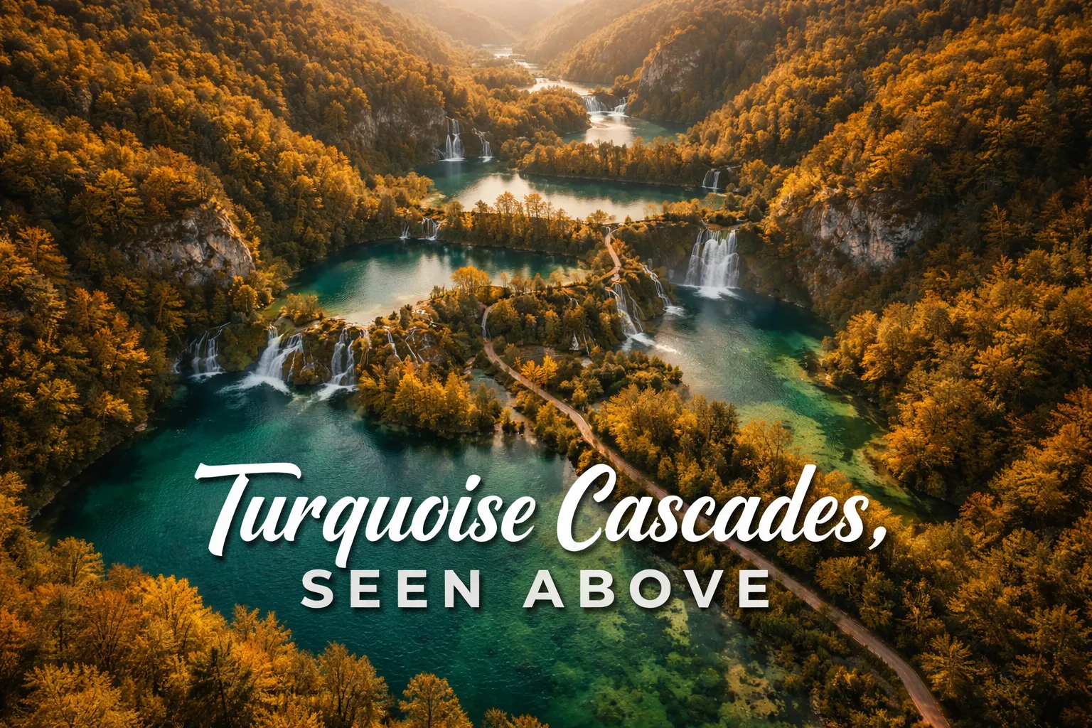
The first time my drone cleared the treeline above Plitvice and I saw the full lake system laid out below me — I actually held my breath. Sixteen terraced lakes, each a slightly different shade of turquoise or emerald depending on the mineral content and the angle of morning light, cascading down a 135-meter drop over 8 kilometers of forested karst canyon. Plitvice Lakes drone photography Croatia is, without question, some of the most visually dramatic aerial work I’ve done anywhere in Europe. The problem? It’s also some of the most legally complicated. This guide gives you the full picture — what the aerial view reveals, what the regulations actually say, and how to approach this UNESCO World Heritage Site as a responsible aerial photographer.
This post contains affiliate links. As an Amazon Associate, I earn from qualifying purchases at no extra cost to you.
Drone Flight Brief: Plitvice Lakes National Park
| Field | Details |
|---|---|
| GPS Coordinates (Park Center) | 44.8800° N, 15.6200° E |
| Recommended Altitude Range | 80–250m AGL for full lake system; 40–80m AGL for waterfall detail shots |
| Best Time of Day | 7:00–9:30 AM (golden hour light hits the water surface at low angles; mist rises off Upper Lakes) |
| Best Season | Late April–May (snowmelt maximizes waterfall volume); October (autumn foliage contrast at peak) |
| Drone Regulations Summary | Drone flight is prohibited inside park boundaries without an official permit from Plitvice Lakes National Park management. Unauthorized flights carry substantial fines. See full regulations section below. |
| Skill Level Required | Advanced (if permitted) — canyon thermals, forest proximity, no open launch sites within park |
| Nearest Legal Consideration Zone | Bordering agricultural land outside park boundary; verify current boundary markers before any launch |
What the Plitvice Lakes Aerial View Actually Reveals
The Plitvice National Park aerial view rewrites everything you thought you understood about this landscape from the ground. Standing on the boardwalks — and yes, I’ve walked every section of them too — you experience the lakes as intimate, close-up environments: the sound of water, the startling clarity of the surface, fish visible at depth. From the air, the lakes transform into something geometric and almost surreal. The travertine barriers that create each waterfall level form irregular, organic ridgelines that from above look like a naturally engineered amphitheater, each terrace holding its own pool before spilling forward.
The color gradient is the detail that no photograph from ground level can prepare you for. From roughly 150m altitude, you can see the distinct color shift between lakes — the Upper Lakes (Gornja jezera) trend toward deeper blue-green due to greater depth and different mineral concentrations, while the Lower Lakes (Donja jezera) glow in a more intense, saturated turquoise in direct sunlight. The shift is driven by calcium carbonate and magnesium content in the water, which interacts differently with light at varying depths. The best altitude for observing and capturing this gradient is 180–220m, where you’re high enough to see multiple lake levels simultaneously but close enough that the color saturation still reads clearly in the frame.
The boardwalk system — over 18 kilometers of wooden walkways threading through and across the lakes — becomes one of the most unexpected compositional elements from altitude. From above, the boardwalks create precise human-scale geometric lines bisecting the organic chaos of the water and forest. The contrast between the straight, ruler-precise boardwalk sections and the asymmetric, naturally carved lake edges is a compositional gift that aerial photography reveals and ground-level photography can never fully capture.
The Upper Lakes vs. Lower Lakes: Two Distinct Aerial Compositions
Understanding that Plitvice is really two photographic environments — separated by the dramatic Veliki Slap waterfall — is essential for planning your aerial approach. The Upper Lakes cover a wider, more open valley. From altitude, they read as a broad, glittering mosaic of water and dense forest, with the lake boundaries softer and less defined. The best altitude for capturing the Upper Lakes as a complete system is 200–250m, where you can compress the full cluster into a single frame. Morning light entering from the east skims across the water surface and creates distinct reflective highlights on each separate lake body, emphasizing the terraced descent.
The Lower Lakes are a fundamentally different aerial subject. The canyon narrows significantly here, the forest closes in on both sides, and the waterfalls are taller and more vertical rather than the wide, cascading sheets of the Upper section. The most famous single feature — Veliki Slap, Croatia’s tallest waterfall at 78 meters — is best captured from a lower altitude of 60–100m, at an angle that allows the full drop to read against the canyon wall behind it. This is the section where thermal activity from the canyon is most unpredictable, and where pilot skill genuinely matters.
Best Time to Photograph Plitvice From Above: Season and Light
The single most important variable in Croatia waterfalls drone photography at Plitvice is water volume, and water volume is driven by season. Late April through mid-May is the definitive peak for waterfall intensity. Snowmelt from the Mala Kapela mountains feeds the system at its maximum rate, and the 90+ waterfalls are running at full capacity — some of the cascade barriers become temporarily submerged, which from above creates the impression of the entire upper terrace system running as one continuous white-water surface. This is visually spectacular but also means the precise travertine geometry is partially obscured.
October is the season I personally prefer for aerial photography here, and I’ll tell you exactly why: the autumn color contrast. The forests surrounding Plitvice turn in stages — beeches shift to gold, maples to deep orange, with evergreens holding their dark green throughout. From 150m altitude in mid-October, the color temperature difference between the warm forest canopy and the cold, mineral-blue water is extraordinary. The turquoise-to-emerald gradient of the lakes reads against a warm amber and rust backdrop that makes each lake color appear more saturated than it does in summer. Water levels are lower than spring but still fully flowing — the travertine barriers are fully visible, which means the geometric terracing is at its most defined from above.
Midwinter offers a third, rarer opportunity: when temperatures drop sufficiently, ice formations partially cover some of the Upper Lakes while waterfalls continue flowing around and beneath the ice. The visual contrast between white ice, flowing dark water, and snowcovered forest is genuinely unlike anything else I’ve photographed in Europe. However, access to the park is limited in winter and the practical logistics of flying in cold temperatures add additional battery management challenges.
Can You Fly a Drone at Plitvice Lakes? Regulations and the Practical Reality
Let me be completely direct with you: drone flight is prohibited inside Plitvice Lakes National Park without an official permit. This is not a gray area or a loosely enforced rule. Plitvice is a UNESCO World Heritage Site and Croatia’s most-visited natural attraction, and the park management enforces the no-fly zone actively. Rangers patrol the park and park visitors have been known to report unauthorized drones. Fines under Croatian law for unauthorized drone operation in protected areas can reach several thousand euros, and equipment confiscation is possible.
The official route is a film and photography permit application submitted directly to Javna ustanova “Nacionalni park Plitvička jezera” (the park’s public institution management body). These permits exist primarily for commercial film and photography productions and come with significant fees and conditions, including requirements for professional liability insurance, specific time windows (typically very early morning before visitor access), and often a requirement that a park representative accompanies the shoot. For most independent travel photographers, this pathway is impractical and expensive.
The realistic alternative that serious aerial photographers use is shooting from outside the park boundary. The national park boundary is marked, and there are elevated positions on agricultural and state forest land bordering the park from which longer telephoto drone shots toward the lake system are possible. These positions don’t provide the directly-overhead perspective that makes the aerial view so compelling, but they can yield dramatic side-angle shots of the Lower Lakes and Veliki Slap from positions technically outside the restricted zone. Always verify current boundary positions with local maps and — critically — consult current Croatian CAA (CCAA) regulations before any flight, as airspace designations are updated periodically.
If you’re researching best drone spots Croatia national parks more broadly, it’s worth knowing that Plitvice is the most restricted. Krka National Park, another waterfall system further south, has similar restrictions inside park boundaries but different topography around the edges. National parks in Croatia consistently require permits for drone operations, and this should be factored into your planning from the start.
The Best Shots to Capture: Compositions, Altitudes, and Angles
Whether you’re working within a permit framework or shooting from permitted positions outside the boundary, these are the specific compositions that the Plitvice Lakes from above drone perspective rewards most:
- The Full System Top-Down at 220–250m: Directly overhead, centered over the middle lake section, this altitude allows you to fit the widest possible span of lakes into a single frame. The terracing reads as a descending staircase of color from this height. Best captured in mid-morning when sunlight has cleared the eastern ridge but not yet reached overhead noon angle.
- The Boardwalk Geometry Shot at 80–120m: Position the drone so that a straight boardwalk section bisects the frame diagonally, with open water on both sides. The wooden walkway creates a leading line through an otherwise organic landscape. This shot is uniquely aerial — it simply cannot be replicated from the ground and is one of the most instantly recognizable compositions from this park.
- Veliki Slap Side Angle at 60–80m: From a position level with or slightly above the top of the falls, shooting across at a roughly 30-degree downward angle, the full 78-meter drop reads against the canyon wall. This is where the Lower Lakes’ canyon character comes through most powerfully. Early morning in autumn, when mist rises off the base pool, adds atmospheric depth.
- The Color Gradient Comparison Shot: Position the drone at 150m over the transition zone between Upper and Lower Lakes, tilted at roughly 45 degrees toward the water. This angle captures multiple lake bodies simultaneously and best shows the mineral-driven color variation between adjacent pools — one of the defining characteristics of Plitvice that ground photography essentially cannot show.
Gear Worth Packing for Plitvice Aerial Photography
Plitvice sits in a forested karst valley with high humidity year-round, and if you visit during the spring snowmelt season, you will encounter mist, light rain, and heavy condensation — sometimes all in the same morning. The PEKREWS Mini 4 Pro Waterproof Hard Carrying Case earned its place in my kit specifically because of environments like this. The waterproof hard shell construction means that when a sudden cloud burst hits while I’m hiking to a shooting position — which happened to me on my second visit here — my drone, controller, and spare batteries are fully protected inside a sealed case that doubles as a travel backpack and fits a 15.6-inch laptop. The ability to carry everything in one carry-on-compatible pack matters enormously at Plitvice because the park’s terrain means you’ll be on foot for extended periods between potential shooting positions. Scrambling through wet forest with an unprotected gear bag is how expensive equipment gets damaged; this case eliminates that risk and the peace of mind is worth every cent.
If you’re flying the DJI Mavic 4 Pro — which is my current recommendation for serious travel aerial work given its camera system and wind resistance — the Lekufee Waterproof Hard Carrying Case for DJI Mavic 4 Pro is purpose-built for this specific drone and its ecosystem. What matters at Plitvice in particular is battery organization: to maximize your permitted shooting window (whether that’s an early morning permit slot or the brief window you have at an outside-boundary position), you want all seven batteries ready to go and organized, not rattling loose in a generic bag. The Lekufee case holds the Mavic 4 Pro, RC Pro 2 or RC 2 controller, up to seven batteries, and a charging hub in a single organized hard shell. When I’ve had a 90-minute pre-dawn window to complete a shoot before park rangers begin their morning patrol, being able to open one case and have everything in its place — rather than hunting through multiple bags in the dark — has genuinely made the difference between a complete shoot and a frustrating half-session.
The waterfall environment at Plitvice creates one of the most challenging exposure scenarios in aerial photography: extremely bright white water against dark, shadowed canyon walls and highly reflective lake surfaces, all in the same frame. This is precisely the scenario where the DJI Mini 4 Pro ND Filters Set (ND16/64/256) proves its value. The ND16 is my default choice during bright mid-morning conditions when the lake surface is reflecting direct sunlight — it cuts the exposure down enough that I can keep the shutter speed in the motion-blur-appropriate range for the waterfalls (typically 1/60 to 1/120s) without overexposing the highlights. The ND64 becomes essential around midday or in full sun on the Upper Lakes when the surface reflection is at maximum intensity. I once tried to shoot Plitvice waterfall detail without filters on a bright May morning and the white-water highlights were completely blown out in every frame — an expensive and frustrating lesson in why this $60 set of filters is non-negotiable for this location.
Connecting Plitvice to Your Broader Croatia Itinerary
Plitvice Lakes is Croatia’s most-visited natural attraction for good reason — it anchors the inland section of almost every serious Croatia itinerary. From a photography travel perspective, it pairs naturally with the Dalmatian Coast to the south, where the aerial and landscape shooting shifts from freshwater karst to Adriatic coastline, medieval walled cities like Dubrovnik, and the scattered islands of the Šibenik archipelago. If you’re planning a Croatia trip that includes both landscapes, budget at least two days at Plitvice — one for ground-level photography on the boardwalk system, and one for your aerial work from permitted positions or for executing any formal permit you’ve arranged in advance. The drive south from Plitvice toward Split along the A1 motorway also passes through striking highland terrain that offers additional aerial opportunities for those with appropriate permits and the flexibility to stop.
Frequently Asked Questions About Plitvice Lakes Drone Photography
Is drone photography allowed at Plitvice Lakes National Park?
No — recreational drone flight is prohibited inside Plitvice Lakes National Park without an official commercial/film permit issued by the park’s management body. The park is a UNESCO World Heritage Site and enforces this restriction actively. Unauthorized drone operation in Croatian protected areas can result in fines of several thousand euros and potential equipment confiscation. Commercial productions can apply for permits, which require professional liability insurance, a park escort, and significant fees. Independent travelers should plan to photograph from designated viewpoints within the park on foot, or research legal launch positions on private or state land outside the park boundary.
What is the best time of year for aerial photography at Plitvice Lakes?
Late April through mid-May offers the maximum water volume — snowmelt from the surrounding mountains pushes all 90+ waterfalls to peak flow, creating dramatic white-water cascade sequences visible from altitude. October is the preferred season for color contrast photography: autumn foliage surrounds the lakes in gold, amber, and orange, creating striking color temperature contrast against the blue-green water. The lake color gradient between upper and lower sections is most visible in autumn when water levels drop enough to fully expose the travertine barrier geometry. Midwinter can offer extraordinary ice-and-waterfall compositions but practical access and battery performance in cold temperatures add logistical complexity.
What altitude is best for photographing the full Plitvice lake system from a drone?
The best altitude for capturing the full terraced lake system as a single composition is 200–250m AGL (above ground level). At this height, you can fit the widest span of interconnected lakes into a single frame and the overall 8-kilometer, 135-meter descending terrace structure becomes legible as a coherent system. For waterfall detail shots — particularly