
| GPS Coordinates (central Meteora) | 39.7217° N, 21.6306° E (near Great Meteoron Monastery) |
| Recommended Altitude Range | 100–220 meters AGL for full pillar-and-monastery compositions |
| Best Time of Day | Golden hour (6:00–8:00 AM) and one hour before sunset |
| Best Season | Late September through November; April through early June |
| Drone Regulations Summary | Drones are heavily restricted within 500m of active monastery buildings; a Greek Civil Aviation Authority (HCAA) permit is required for commercial flight; recreational flight in buffer zones is not permitted without authorization. Flying is legally possible from specific open ground positions away from monastery grounds — see full regulations section below. |
| Nearest City / Access Point | Kalambaka (2 km south); Kastraki village (1 km west) |
| Skill Level Required | Intermediate to Advanced — mountain thermals, unpredictable wind shear, and restricted airspace demand confident stick control and pre-planned flight paths |
| Emergency Note | Mobile signal is unreliable at many pillar-base launch points; download offline maps before arrival |
What the Meteora Aerial View Reveals That Ground-Level Visitors Never See
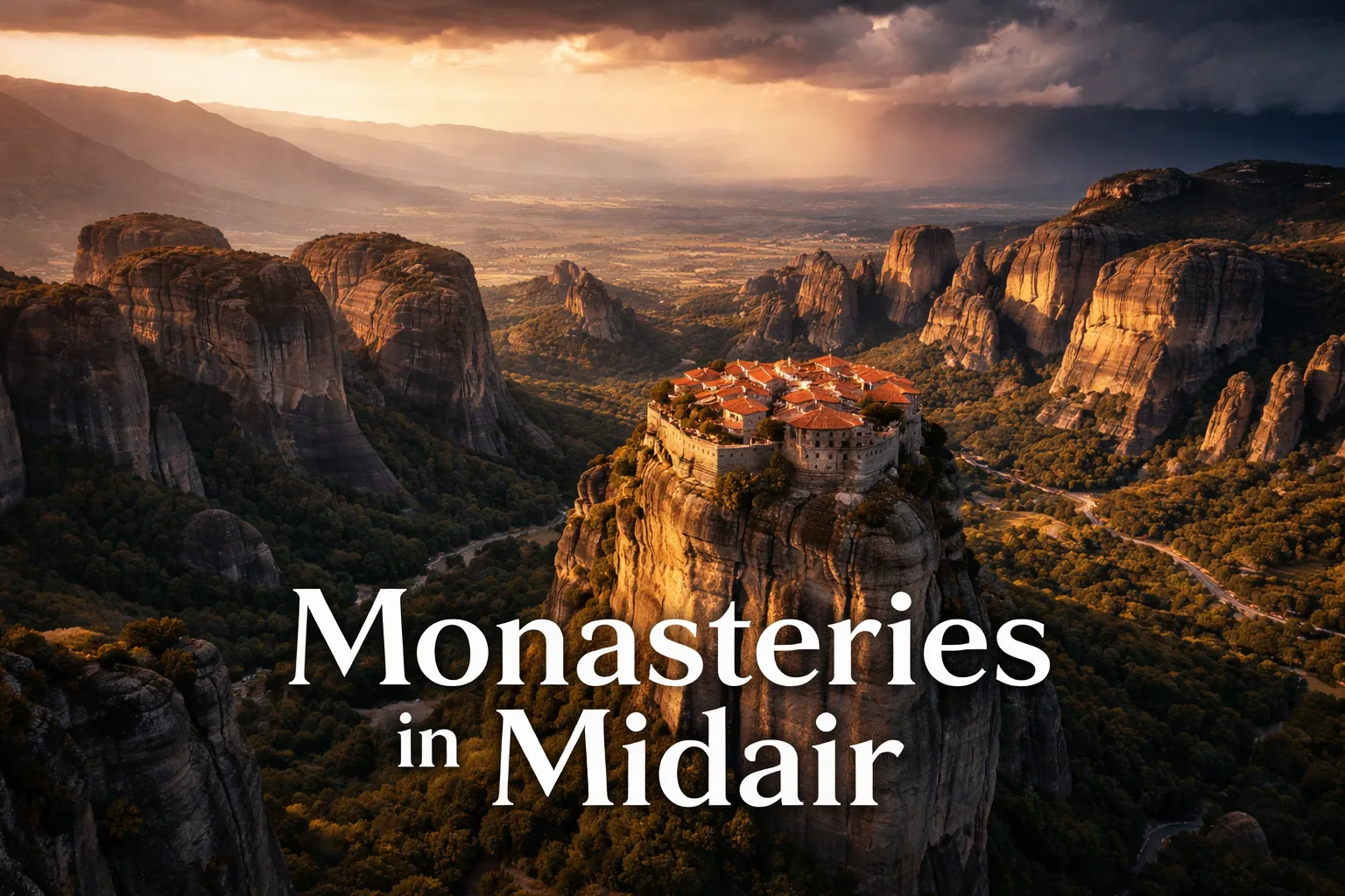
Standing on the road between Kastraki and the monasteries, you see walls, staircases carved into rock faces, and distant rooftops. From a drone delivering a true meteora aerial view monasteries perspective, the entire architectural and geological logic of this place snaps into focus in a way that is genuinely difficult to overstate. The first thing that strikes you is the rooftop gardens of the Great Meteoron — red-tiled roofing punctuated by small vegetable plots and monastery courtyards that no pilgrim on the ground ever sees. From 150 meters directly above, these hidden green spaces look like secret worlds suspended in the sky.
The second revelation is geological. These are not separate mountains — they are individual conglomerate pillars, remnants of a delta riverbed that the Peneus River spent millions of years eroding into vertical towers. From altitude, you can trace the spacing between pillars and see how the monastery builders of the 14th century identified the specific towers with wide enough flat tops to support construction. The pilgrim path network — a system of stepped trails, rope ladders replaced by modern staircases, and narrow saddle-crossings between adjacent pillar tops — becomes completely legible from above in a way that is invisible from any road-level vantage point. I spent twenty minutes on my first flight just tracing these connections, watching how each of the six active monasteries is part of one continuous (if terrifying) high-altitude walkway system across the pillar tops.
Third: the plain. When you are standing in Kalambaka, the surrounding flatness of the Thessaly basin feels normal. From 200 meters above the pillars, the contrast is violent and magnificent — these towers erupt from completely flat agricultural land with no transitional foothills, no gradual elevation change, nothing. The meteora rock pillars from above look like a geological eruption frozen mid-explosion, surrounded by green and gold farmland running to the foot of the Pindus Mountains on the western horizon.
The Best Shots to Capture: Meteora Monasteries Drone Photography Greece
The Great Meteoron Overhead Shot
The single most compelling image in greece drone photography monasteries work at Meteora is a true nadir (straight-down) shot of the Great Meteoron from approximately 180–200 meters AGL. At this altitude, the full footprint of the monastery complex becomes visible — the main church with its distinctive grey dome, the surrounding courtyard, the kitchen gardens, and most dramatically, the sheer drop on all four sides. Position your drone slightly northeast of the monastery in early morning so the low sun casts the pillar’s shadow westward across the plain, giving the image depth and scale. The contrast between the warm stone roofing and the vertical cliff faces dropping away on every side is the defining image of Meteora from above.
Varlaam and Roussanou in Tandem
Varlaam and Roussanou monasteries sit on adjacent pillars with a dramatic gap between them — a composition that is simply not accessible from the ground at any angle. From approximately 120–140 meters and a lateral position to the northwest, you can frame both monasteries in a single wide shot with the valley floor visible between their respective pillars. This shot works exceptionally well in the 20–30 minutes before full sunset, when the drone flying over meteora greece captures the pillars turning deep amber-gold while the sky behind them transitions through purple and orange. If there are thunderclouds building over the Pindus range to the west — something that happens regularly in September and October — this composition becomes extraordinary.
The Pillar Geology Shot — East Face at Dawn
For pure geology, launch before sunrise from the lower road east of the pillar cluster and let the drone rise to 100 meters while facing west. As the sun clears the Thessaly plain behind you, the raking light hits the east-facing conglomerate surfaces and reveals every layer of sedimentary history in the rock — the rounded river pebbles embedded in the sandstone matrix become individually visible, an almost tactile image of 60 million years of geological time. This shot requires precise positioning: too high and you lose the texture; too low and the monastery buildings disappear. The 100–120 meter range is the sweet spot where you see both the geological detail and the scale of the full pillar height.
Can You Fly a Drone at Meteora? Regulations and the Practical Reality
This is the section most drone photographers need most and find least honest information about — so let me be direct. Flying a drone freely over the monastery buildings at Meteora is not legally permitted without prior authorization from the Greek Civil Aviation Authority (HCAA) and, in many cases, from the Holy Monastery administration itself. The monasteries are active religious sites under the jurisdiction of the Greek Orthodox Church, and they sit within a UNESCO World Heritage buffer zone that carries additional airspace restrictions. Flying directly over monastery buildings without permits risks confiscation of equipment, significant fines under Greek aviation law (Law 4663/2020), and — importantly — real harm to a place that deserves respect.
Here is the practical reality for recreational photographers: there are legal launch zones in the broader Meteora geological area — open ground well outside the 500-meter monastery buffer zones — from which you can achieve genuinely spectacular images. The road area near the Kastraki viewpoint and certain positions along the lower valley road provide legal take-off points from which your drone can legally gain altitude and capture wide compositions of the pillar cluster. The key is that you are not flying over restricted monastery property, and your altitude keeps you in uncontrolled airspace above 120 meters AGL where Greek recreational rules allow flight. For commercial or professional photography work, the HCAA permit process is manageable — applications are submitted through the HCAA D-Flight portal — but allow 4–6 weeks and have your liability insurance documentation ready. Several local Kalambaka-based photography companies have established monastery permissions and offer guided aerial sessions; this is often the most practical route for a one-time visit.
Bottom line: do not launch from monastery car parks or courtyards, do not fly directly over the buildings without permits, and do not assume that because you can see no one watching, it is permitted. The monasteries are actively managed, the site is heavily visited, and enforcement does occur.
Best Time to Photograph Meteora From Above
The Thessaly plain is a thermal engine in summer — by 10:00 AM from June through August, the flat agricultural land heats rapidly and sends unpredictable thermals up through the pillar cluster that make smooth drone footage extremely challenging and frankly dangerous for less experienced pilots. The best flight conditions at Meteora are found in the shoulder seasons: late September through November gives you dramatic storm-light possibilities, lower visitor numbers, and the harvest gold of the plains creating a stunning landscape backdrop. April through early June offers wildflowers on the hillsides, green plains, and softer morning light without the brutal summer heat haze that washes out distant detail in telephoto shots.
For time of day, the mathematics are straightforward: golden hour at Meteora runs approximately 6:00–8:00 AM in summer and 7:00–8:30 AM in autumn, and the low-angle eastern sun raking across the west-facing monastery walls creates the warmth and shadow depth that defines the best aerial images from this location. Evening golden hour — the hour before sunset — is equally spectacular and offers the added drama of the Pindus Mountain backdrop catching the last light. Midday shooting is not worthless — the overhead sun at noon creates strong shadows between pillar towers and produces dramatic contrast in black-and-white post-processing — but it is not where your best colour footage will come from.
Gear Worth Packing for Meteora Aerial Photography
For serious Meteora aerial work, the DJI Air 3S with RC-N3 Controller is the drone I would choose for this location without hesitation. The 1-inch CMOS sensor with 14 stops of dynamic range is not a marketing specification — it is the practical difference between capturing the full tonal range from the bright Thessaly sky to the deep shadow inside pillar crevices in a single exposure, which is exactly the contrast situation you face at Meteora during golden hour. The 4K/60fps HDR video capability means your footage retains highlight detail in the sky while keeping shadow detail in the rock faces — something smaller-sensor drones consistently fail at in this high-contrast environment. At 45 minutes of flight time per battery, you have enough endurance to plan a complete orbital sequence around a monastery pillar, reposition for a second composition, and still return with reserve. The 20km transmission range is irrelevant at Meteora specifically, but the signal stability at altitude matters — I have had cheaper drones lose FPV feed at 150 meters in the rocky terrain here, and the Air 3S held clean signal throughout every flight.
If you are already flying the DJI Air 3 and are considering a backup aircraft for a trip of this significance, the DJI Air 3 Aircraft Only replacement unit is worth packing as your emergency spare — and at Meteora, the case for this is stronger than almost anywhere else in Europe. The combination of mountain thermals, unpredictable wind shear between pillar towers, and the fact that a downed drone in this terrain is almost certainly unrecoverable (vertical cliff faces, inaccessible monastery grounds) means that flying with no backup aircraft here is a genuine risk to your entire trip’s photographic output. This replacement unit ships without controller or batteries — meaning it pairs with your existing setup — so the additional weight in your bag is purely the aircraft body. I have never needed mine at Meteora, but the one time I clipped a rotor on a rocky outcrop at a different mountain location and lost three days of planned shooting, I swore I would never travel to a remote high-stakes location without a backup aircraft again.
For photographers who are newer to aerial work or travelling with checked baggage weight concerns, the DJI Mini 3 Fly More Combo with DJI RC is a legitimate and capable choice for Meteora — with one important caveat. The Mini 3’s sub-250g weight exempts it from certain EU drone registration categories, which simplifies your regulatory paperwork considerably when flying in Greece as a foreign visitor. The Fly More Combo’s three-battery setup gives you 114 minutes of total flight time across a session, which is genuinely enough to cover multiple compositions across the pillar cluster in a single morning outing. The vertical shooting mode — a feature unique to the Mini 3 in this class — produces portrait-orientation footage that is ideal for monastery pillar compositions that are inherently tall and narrow rather than wide. What the Mini 3 does give up relative to larger sensors is dynamic range in high-contrast light — plan your flights for softer golden-hour conditions rather than harsh midday contrast, and the image quality from this compact machine will consistently impress you.
Frequently Asked Questions About Drone Photography at Meteora
Is drone flying permitted at Meteora, Greece?
Drone flying is restricted but not categorically banned throughout the entire Meteora area. Flying directly over or within 500 meters of the active monastery buildings requires prior authorization from the Greek Civil Aviation Authority (HCAA) and, for commercial work, from the monastery administration. Recreational pilots can legally fly from designated open ground positions in the broader geological area outside these buffer zones. Always check the HCAA D-Flight portal for current NOTAMs before flying, as temporary restrictions are sometimes imposed during religious feast days and major visitor events.
What is the best altitude for photographing the Meteora monasteries from a drone?
The best altitude range for Meteora monastery compositions is 100–220 meters AGL, depending on the shot type. For nadir (straight-down) rooftop shots of individual monasteries, 180–200 meters provides full monastery footprint visibility with sufficient context of the surrounding cliff faces. For lateral compositions showing two monasteries in the same frame — such as Varlaam and Roussanou — 120–140 meters from a northwest position delivers the strongest spatial relationship between the two structures. For geological detail shots of the pillar rock faces, 80–120 meters with a low sun angle produces the best texture and depth.
What is the best time of year to visit Meteora for drone photography?
Late September through November is the single best period for Meteora drone photography. This window combines stable morning flight conditions before thermal activity begins, dramatic autumn storm-light possibilities with thunderclouds over the Pindus Mountains, lower visitor numbers (meaning fewer people visible in aerial shots of monastery paths), and the warm amber of harvested Thessaly plain farmland providing an outstanding landscape backdrop. April through early June is the second-best window, offering spring wildflowers and green plains with reliably soft morning light. Avoid July and August for serious aerial work — summer thermals create hazardous flying conditions by mid-morning and heat haze significantly degrades image quality.
Do I need to register my drone before flying in Greece?
Greece follows EU drone regulation framework (EU 2019/947). Drones over 250 grams require operator registration with the HCAA before any flight in Greek airspace, including at Meteora. Drones under 250 grams — such as the DJI Mini 3 — have simplified requirements but are not entirely regulation-free; you must still operate within open-category rules and cannot fly over crowds or restricted zones. Foreign EU citizens can use their home-country registration in Greece; non-EU visitors must register directly with the HCAA. The registration process is completed through the HCAA’s online portal and takes 1–3 business days.
What makes Meteora uniquely challenging for drone pilots compared to other aerial photography locations?
Meteora presents three specific challenges that distinguish it from most drone photography destinations. First, thermal activity: the flat Thessaly plain heats rapidly in spring and summer, generating strong vertical air currents between the pillar towers that can disorient smaller drones and require constant manual correction. Second, restricted airspace complexity: the layered restrictions around UNESCO heritage zones, active religious sites, and Greek national park land mean the legal flight envelope is narrower than a quick map review suggests — each individual monastery has its own buffer zone that must be mapped before flight. Third, recovery impossibility: if a drone goes down on a monastery pillar or in a vertical cliff crevice, there is no realistic recovery
This post contains affiliate links. As an Amazon Associate, I earn from qualifying purchases at no extra cost to you.
The moment my drone cleared the treeline above the Thessaly plain and the full scale of Meteora revealed itself on my controller screen, I genuinely lost my breath. Nothing — not the guidebooks, not the photographs, not even standing at the base of the pillars — had prepared me for what meteora monasteries drone photography greece actually delivers from altitude: six medieval monasteries balanced on the tips of 60-million-year-old sandstone towers like crowns on stone giants, surrounded by an ocean of flat agricultural plain stretching to the horizon in every direction. From the ground, you look up and feel small. From a drone at 180 meters, you understand for the first time just how impossibly these structures were placed — and why Meteora is arguably the most dramatic aerial photography location in all of Europe.
Drone Flight Brief: Meteora, Greece — Quick-Reference Data
| GPS Coordinates (central Meteora) | 39.7217° N, 21.6306° E (near Great Meteoron Monastery) |
| Recommended Altitude Range | 100–220 meters AGL for full pillar-and-monastery compositions |
| Best Time of Day | Golden hour (6:00–8:00 AM) and one hour before sunset |
| Best Season | Late September through November; April through early June |
| Drone Regulations Summary | Drones are heavily restricted within 500m of active monastery buildings; a Greek Civil Aviation Authority (HCAA) permit is required for commercial flight; recreational flight in buffer zones is not permitted without authorization. Flying is legally possible from specific open ground positions away from monastery grounds — see full regulations section below. |
| Nearest City / Access Point | Kalambaka (2 km south); Kastraki village (1 km west) |
| Skill Level Required | Intermediate to Advanced — mountain thermals, unpredictable wind shear, and restricted airspace demand confident stick control and pre-planned flight paths |
| Emergency Note | Mobile signal is unreliable at many pillar-base launch points; download offline maps before arrival |
What the Meteora Aerial View Reveals That Ground-Level Visitors Never See
Standing on the road between Kastraki and the monasteries, you see walls, staircases carved into rock faces, and distant rooftops. From a drone delivering a true meteora aerial view monasteries perspective, the entire architectural and geological logic of this place snaps into focus in a way that is genuinely difficult to overstate. The first thing that strikes you is the rooftop gardens of the Great Meteoron — red-tiled roofing punctuated by small vegetable plots and monastery courtyards that no pilgrim on the ground ever sees. From 150 meters directly above, these hidden green spaces look like secret worlds suspended in the sky.
The second revelation is geological. These are not separate mountains — they are individual conglomerate pillars, remnants of a delta riverbed that the Peneus River spent millions of years eroding into vertical towers. From altitude, you can trace the spacing between pillars and see how the monastery builders of the 14th century identified the specific towers with wide enough flat tops to support construction. The pilgrim path network — a system of stepped trails, rope ladders replaced by modern staircases, and narrow saddle-crossings between adjacent pillar tops — becomes completely legible from above in a way that is invisible from any road-level vantage point. I spent twenty minutes on my first flight just tracing these connections, watching how each of the six active monasteries is part of one continuous (if terrifying) high-altitude walkway system across the pillar tops.
Third: the plain. When you are standing in Kalambaka, the surrounding flatness of the Thessaly basin feels normal. From 200 meters above the pillars, the contrast is violent and magnificent — these towers erupt from completely flat agricultural land with no transitional foothills, no gradual elevation change, nothing. The meteora rock pillars from above look like a geological eruption frozen mid-explosion, surrounded by green and gold farmland running to the foot of the Pindus Mountains on the western horizon.
The Best Shots to Capture: Meteora Monasteries Drone Photography Greece
The Great Meteoron Overhead Shot
The single most compelling image in greece drone photography monasteries work at Meteora is a true nadir (straight-down) shot of the Great Meteoron from approximately 180–200 meters AGL. At this altitude, the full footprint of the monastery complex becomes visible — the main church with its distinctive grey dome, the surrounding courtyard, the kitchen gardens, and most dramatically, the sheer drop on all four sides. Position your drone slightly northeast of the monastery in early morning so the low sun casts the pillar’s shadow westward across the plain, giving the image depth and scale. The contrast between the warm stone roofing and the vertical cliff faces dropping away on every side is the defining image of Meteora from above.
Varlaam and Roussanou in Tandem
Varlaam and Roussanou monasteries sit on adjacent pillars with a dramatic gap between them — a composition that is simply not accessible from the ground at any angle. From approximately 120–140 meters and a lateral position to the northwest, you can frame both monasteries in a single wide shot with the valley floor visible between their respective pillars. This shot works exceptionally well in the 20–30 minutes before full sunset, when the drone flying over meteora greece captures the pillars turning deep amber-gold while the sky behind them transitions through purple and orange. If there are thunderclouds building over the Pindus range to the west — something that happens regularly in September and October — this composition becomes extraordinary.
The Pillar Geology Shot — East Face at Dawn
For pure geology, launch before sunrise from the lower road east of the pillar cluster and let the drone rise to 100 meters while facing west. As the sun clears the Thessaly plain behind you, the raking light hits the east-facing conglomerate surfaces and reveals every layer of sedimentary history in the rock — the rounded river pebbles embedded in the sandstone matrix become individually visible, an almost tactile image of 60 million years of geological time. This shot requires precise positioning: too high and you lose the texture; too low and the monastery buildings disappear. The 100–120 meter range is the sweet spot where you see both the geological detail and the scale of the full pillar height.
Can You Fly a Drone at Meteora? Regulations and the Practical Reality
This is the section most drone photographers need most and find least honest information about — so let me be direct. Flying a drone freely over the monastery buildings at Meteora is not legally permitted without prior authorization from the Greek Civil Aviation Authority (HCAA) and, in many cases, from the Holy Monastery administration itself. The monasteries are active religious sites under the jurisdiction of the Greek Orthodox Church, and they sit within a UNESCO World Heritage buffer zone that carries additional airspace restrictions. Flying directly over monastery buildings without permits risks confiscation of equipment, significant fines under Greek aviation law (Law 4663/2020), and — importantly — real harm to a place that deserves respect.
Here is the practical reality for recreational photographers: there are legal launch zones in the broader Meteora geological area — open ground well outside the 500-meter monastery buffer zones — from which you can achieve genuinely spectacular images. The road area near the Kastraki viewpoint and certain positions along the lower valley road provide legal take-off points from which your drone can legally gain altitude and capture wide compositions of the pillar cluster. The key is that you are not flying over restricted monastery property, and your altitude keeps you in uncontrolled airspace above 120 meters AGL where Greek recreational rules allow flight. For commercial or professional photography work, the HCAA permit process is manageable — applications are submitted through the HCAA D-Flight portal — but allow 4–6 weeks and have your liability insurance documentation ready. Several local Kalambaka-based photography companies have established monastery permissions and offer guided aerial sessions; this is often the most practical route for a one-time visit.
Bottom line: do not launch from monastery car parks or courtyards, do not fly directly over the buildings without permits, and do not assume that because you can see no one watching, it is permitted. The monasteries are actively managed, the site is heavily visited, and enforcement does occur.
Best Time to Photograph Meteora From Above
The Thessaly plain is a thermal engine in summer — by 10:00 AM from June through August, the flat agricultural land heats rapidly and sends unpredictable thermals up through the pillar cluster that make smooth drone footage extremely challenging and frankly dangerous for less experienced pilots. The best flight conditions at Meteora are found in the shoulder seasons: late September through November gives you dramatic storm-light possibilities, lower visitor numbers, and the harvest gold of the plains creating a stunning landscape backdrop. April through early June offers wildflowers on the hillsides, green plains, and softer morning light without the brutal summer heat haze that washes out distant detail in telephoto shots.
For time of day, the mathematics are straightforward: golden hour at Meteora runs approximately 6:00–8:00 AM in summer and 7:00–8:30 AM in autumn, and the low-angle eastern sun raking across the west-facing monastery walls creates the warmth and shadow depth that defines the best aerial images from this location. Evening golden hour — the hour before sunset — is equally spectacular and offers the added drama of the Pindus Mountain backdrop catching the last light. Midday shooting is not worthless — the overhead sun at noon creates strong shadows between pillar towers and produces dramatic contrast in black-and-white post-processing — but it is not where your best colour footage will come from.
Gear Worth Packing for Meteora Aerial Photography
For serious Meteora aerial work, the DJI Air 3S with RC-N3 Controller is the drone I would choose for this location without hesitation. The 1-inch CMOS sensor with 14 stops of dynamic range is not a marketing specification — it is the practical difference between capturing the full tonal range from the bright Thessaly sky to the deep shadow inside pillar crevices in a single exposure, which is exactly the contrast situation you face at Meteora during golden hour. The 4K/60fps HDR video capability means your footage retains highlight detail in the sky while keeping shadow detail in the rock faces — something smaller-sensor drones consistently fail at in this high-contrast environment. At 45 minutes of flight time per battery, you have enough endurance to plan a complete orbital sequence around a monastery pillar, reposition for a second composition, and still return with reserve. The 20km transmission range is irrelevant at Meteora specifically, but the signal stability at altitude matters — I have had cheaper drones lose FPV feed at 150 meters in the rocky terrain here, and the Air 3S held clean signal throughout every flight.
If you are already flying the DJI Air 3 and are considering a backup aircraft for a trip of this significance, the DJI Air 3 Aircraft Only replacement unit is worth packing as your emergency spare — and at Meteora, the case for this is stronger than almost anywhere else in Europe. The combination of mountain thermals, unpredictable wind shear between pillar towers, and the fact that a downed drone in this terrain is almost certainly unrecoverable (vertical cliff faces, inaccessible monastery grounds) means that flying with no backup aircraft here is a genuine risk to your entire trip’s photographic output. This replacement unit ships without controller or batteries — meaning it pairs with your existing setup — so the additional weight in your bag is purely the aircraft body. I have never needed mine at Meteora, but the one time I clipped a rotor on a rocky outcrop at a different mountain location and lost three days of planned shooting, I swore I would never travel to a remote high-stakes location without a backup aircraft again.
For photographers who are newer to aerial work or travelling with checked baggage weight concerns, the DJI Mini 3 Fly More Combo with DJI RC is a legitimate and capable choice for Meteora — with one important caveat. The Mini 3’s sub-250g weight exempts it from certain EU drone registration categories, which simplifies your regulatory paperwork considerably when flying in Greece as a foreign visitor. The Fly More Combo’s three-battery setup gives you 114 minutes of total flight time across a session, which is genuinely enough to cover multiple compositions across the pillar cluster in a single morning outing. The vertical shooting mode — a feature unique to the Mini 3 in this class — produces portrait-orientation footage that is ideal for monastery pillar compositions that are inherently tall and narrow rather than wide. What the Mini 3 does give up relative to larger sensors is dynamic range in high-contrast light — plan your flights for softer golden-hour conditions rather than harsh midday contrast, and the image quality from this compact machine will consistently impress you.
Frequently Asked Questions About Drone Photography at Meteora
Is drone flying permitted at Meteora, Greece?
Drone flying is restricted but not categorically banned throughout the entire Meteora area. Flying directly over or within 500 meters of the active monastery buildings requires prior authorization from the Greek Civil Aviation Authority (HCAA) and, for commercial work, from the monastery administration. Recreational pilots can legally fly from designated open ground positions in the broader geological area outside these buffer zones. Always check the HCAA D-Flight portal for current NOTAMs before flying, as temporary restrictions are sometimes imposed during religious feast days and major visitor events.
What is the best altitude for photographing the Meteora monasteries from a drone?
The best altitude range for Meteora monastery compositions is 100–220 meters AGL, depending on the shot type. For nadir (straight-down) rooftop shots of individual monasteries, 180–200 meters provides full monastery footprint visibility with sufficient context of the surrounding cliff faces. For lateral compositions showing two monasteries in the same frame — such as Varlaam and Roussanou — 120–140 meters from a northwest position delivers the strongest spatial relationship between the two structures. For geological detail shots of the pillar rock faces, 80–120 meters with a low sun angle produces the best texture and depth.
What is the best time of year to visit Meteora for drone photography?
Late September through November is the single best period for Meteora drone photography. This window combines stable morning flight conditions before thermal activity begins, dramatic autumn storm-light possibilities with thunderclouds over the Pindus Mountains, lower visitor numbers (meaning fewer people visible in aerial shots of monastery paths), and the warm amber of harvested Thessaly plain farmland providing an outstanding landscape backdrop. April through early June is the second-best window, offering spring wildflowers and green plains with reliably soft morning light. Avoid July and August for serious aerial work — summer thermals create hazardous flying conditions by mid-morning and heat haze significantly degrades image quality.
Do I need to register my drone before flying in Greece?
Greece follows EU drone regulation framework (EU 2019/947). Drones over 250 grams require operator registration with the HCAA before any flight in Greek airspace, including at Meteora. Drones under 250 grams — such as the DJI Mini 3 — have simplified requirements but are not entirely regulation-free; you must still operate within open-category rules and cannot fly over crowds or restricted zones. Foreign EU citizens can use their home-country registration in Greece; non-EU visitors must register directly with the HCAA. The registration process is completed through the HCAA’s online portal and takes 1–3 business days.
What makes Meteora uniquely challenging for drone pilots compared to other aerial photography locations?
Meteora presents three specific challenges that distinguish it from most drone photography destinations. First, thermal activity: the flat Thessaly plain heats rapidly in spring and summer, generating strong vertical air currents between the pillar towers that can disorient smaller drones and require constant manual correction. Second, restricted airspace complexity: the layered restrictions around UNESCO heritage zones, active religious sites, and Greek national park land mean the legal flight envelope is narrower than a quick map review suggests — each individual monastery has its own buffer zone that must be mapped before flight. Third, recovery impossibility: if a drone goes down on a monastery pillar or in a vertical cliff crevice, there is no realistic recovery