
Antelope Canyon Drone Photography Arizona: What You See When the Canyon Disappears
The first time I sent a drone up over the desert plateau near Page, Arizona, I experienced one of the most disorienting moments in my entire aerial photography career. I was expecting to look down at something — a canyon, a chasm, a geological spectacle. Instead, I saw almost nothing. Just flat, rust-colored sandstone stretching in every direction like a cracked terracotta tile floor baking in the Sonoran sun. And then, as the altitude climbed to about 80 meters, a thin dark line appeared — barely wider than a crack in old concrete — snaking across the landscape like a surgical incision. That was Antelope Canyon. One of the most photographed places on Earth, and from the air, it’s practically invisible. That invisibility is, paradoxically, exactly what makes antelope canyon drone photography arizona so extraordinary, so challenging, and so worth pursuing — even if the canyon itself is entirely off-limits for drone flight.
Let me be clear from the start: you cannot legally fly a drone over Antelope Canyon. The canyon sits on Navajo Nation land, and the Navajo Nation enforces a blanket ban on drone operations across all tribal lands without explicit tribal authorization — which is not granted for tourist or commercial photography purposes. This post covers what the aerial view of this region actually reveals, the legal alternatives that deliver some of the most stunning aerial landscape images in North America, and everything you need to know to plan a productive and legal drone photography trip to the Page, Arizona corridor.
Drone Flight Brief: Page, Arizona Aerial Photography at a Glance
| Primary Legal Aerial Location | Horseshoe Bend Overlook Area, Page, AZ (36.8791° N, 111.5100° W) |
| Antelope Canyon Coordinates | 36.8619° N, 111.3743° W (Upper) — drone flight NOT permitted |
| Recommended Altitude Range | 60–120 meters for Horseshoe Bend; 80–200 meters for Lake Powell canyon systems |
| Best Time of Day to Fly | Golden hour (6:00–7:30 AM) for warm canyon light; blue hour for Colorado River reflections |
| Best Season | March–May and September–November for optimal light angle and manageable winds |
| Drone Regulations Summary | Antelope Canyon: BANNED (Navajo Nation tribal land). Horseshoe Bend: Glen Canyon NRA jurisdiction — check current NPS permit requirements. Lake Powell shoreline: mixed jurisdiction, verify per location. Always check LAANC for airspace authorization. |
| Skill Level Required | Intermediate — strong desert winds, tight canyon thermals near rim edges, high-contrast lighting |
| Nearest Airport (Airspace Check) | Page Municipal Airport (PGA) — check B4UFLY and LAANC before every flight |
Can You Fly a Drone at Antelope Canyon? The Honest Answer
No. Full stop, and this is non-negotiable. The Navajo Nation maintains a comprehensive drone prohibition across all tribal lands, including both Upper Antelope Canyon (Tsé bighánílíní) and Lower Antelope Canyon (Hazdistazí). This isn’t a gray area or a regulation that’s loosely enforced — it is tribal law on sovereign land, and violations carry serious legal consequences. The Navajo Nation Park Service does not issue permits for recreational or commercial aerial photography by outside operators. I’ve seen drone footage of Antelope Canyon circulating online, and in virtually every case, that footage was obtained illegally. Beyond the legal risk, flying drones over sacred Navajo cultural sites without authorization is a profound breach of respect for the Diné people whose ancestors’ land this is.
What about the canyon’s famous guided tours? Tour operators who run the interior photography experiences at Upper Antelope Canyon also enforce the no-drone policy strictly. If you arrive with a drone visible in your kit, you risk being turned away from the tour entirely. Leave the drone in your vehicle when visiting the canyon interiors, and redirect your aerial ambitions to the remarkable legal alternatives just minutes away.
What the Antelope Canyon Aerial View Reveals (And Why Altitude Changes Everything)
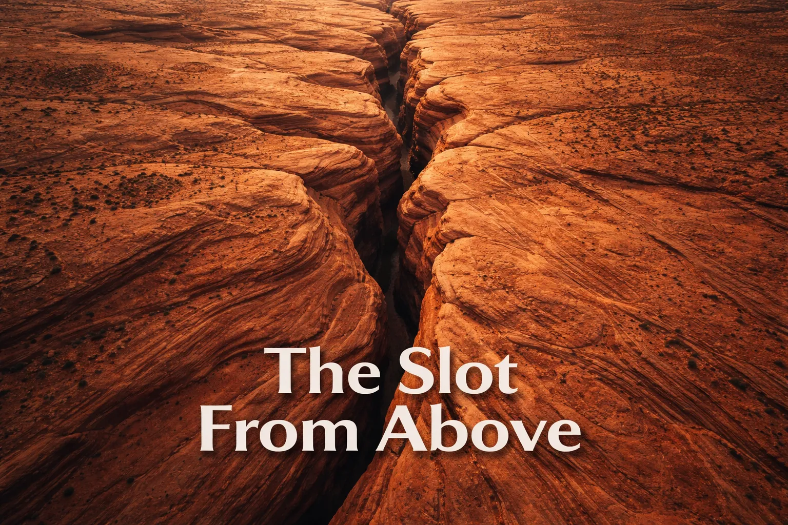
Even studying satellite imagery — which is legal, and I’d encourage every aerial photographer visiting this region to spend time on Google Earth before arriving — reveals something that no ground-level photograph ever communicates: the antelope canyon aerial view slot canyon system is part of a much larger network of parallel erosion channels carved into the Navajo sandstone by millennia of flash flood events. From altitude, you can trace the complete flash flood drainage basin that feeds Antelope Canyon. The wash runs nearly 11 kilometers from the higher elevation desert into Lake Powell, and from above you can see how the entire landscape funnels precipitation into those narrow slots like water draining into a crack in a bathtub.
The second revelation is scale. From inside the canyon, the undulating walls feel cathedral-large, overwhelming. From altitude — even simulated altitude via satellite imagery — the entire slot system is barely a scratch on the landscape. Upper Antelope Canyon is approximately 300 meters long. At 150 meters of altitude, you could frame the entire canyon length in a single wide-angle shot with room to show the surrounding plateau context. That contrast — the world’s most photographed canyon reduced to a thin dark thread — is the aerial image that tells the story no interior shot can.
The third revelation is the geology itself. From above, the parallel wave patterns in the sandstone that create those gorgeous swooping interior walls appear as a series of elongated ridgelines running roughly northeast-southwest, aligned with the prevailing wind patterns that originally deposited the Navajo sandstone as ancient sand dunes approximately 190 million years ago during the Jurassic period. The slots cut perpendicular to those dune layers, which is why the interior walls display such dramatic cross-bedded patterns. At altitude, you’re essentially looking at the top of a fossilized dune field — and the canyons are just where water found the weaknesses.
The Legal Aerial Gems: Best Drone Photography Spots Near Page, Arizona
Horseshoe Bend: The Icon That Delivers From Every Altitude
Horseshoe Bend is, without question, one of the most spectacular drone photography arizona slot canyons and river bend subjects on the continent. Located approximately 8 kilometers south of Page on Highway 89, Horseshoe Bend is where the Colorado River executes a nearly perfect 270-degree meander, dropping approximately 300 meters below the canyon rim. At 80 meters of altitude above the rim, you’re looking down at the full horseshoe shape with the turquoise-green Colorado threading through it — an image that has become one of the defining American landscape aerial photographs of the drone era. The best altitude for photographing Horseshoe Bend by drone is between 60 and 100 meters above the rim, because this range captures the complete horseshoe geometry while maintaining enough foreground interest from the canyon walls. Go higher than 150 meters and the dramatic depth compression begins to flatten the image; the sheer drop that makes Horseshoe Bend so viscerally powerful starts to disappear.
Critically, always verify current National Park Service and Glen Canyon National Recreation Area regulations before flying here. Drone regulations at Horseshoe Bend have evolved over recent years, and the NPS has periodically required permits or restricted flight in certain zones. Check the official NPS website, LAANC authorization, and B4UFLY on the morning of your planned flight — not just the night before.
Lake Powell Canyon Systems: Aerial Scale You Won’t Believe
Lake Powell’s labyrinthine canyon network, visible only from altitude, is arguably one of the most underrated page arizona drone spots in the American Southwest. The reservoir fills hundreds of side canyons carved by the same geological forces that created Antelope Canyon, and from 150–200 meters altitude, the contrast between the deep blue-green water snaking through burnt-orange canyon walls creates color combinations that feel almost artificially saturated. The Chains area and Lone Rock Beach are popular launch points with relatively clear jurisdiction (Glen Canyon NRA — always verify current regs). The canyon fingers visible from altitude near Wahweap Marina are accessible for legal aerial work and deliver compositions that genuinely rival anything you’ll find in aerial photography portfolios from Zion or Bryce Canyon.
The Surrounding Desert Plateau: Invisible Geology Made Visible
The desert plateau between Page and the canyon systems rewards patient aerial photographers with abstract pattern work that most visitors completely miss. At 100–180 meters altitude, the cross-bedded sandstone formations, wind erosion channels, and color-banded geological strata create images that look more like macro photography of mineral samples than landscape aerials. The late afternoon light — roughly 4:00–6:00 PM in summer, 3:00–5:00 PM in winter — rakes across these surface textures and turns the plateau into a topographic relief map rendered in amber and crimson.
Best Time to Photograph the Page Arizona Region From Above
The Page, Arizona corridor sits at approximately 1,290 meters elevation in the high desert, and the light behaves differently here than at lower desert elevations. The golden hour light at Horseshoe Bend arrives with a warm reddish quality rather than the yellow-orange glow you’d get at sea level — the thin, dry air scatters less blue light, and the canyon walls themselves act as secondary reflectors, bouncing warm tones back up into the scene. My strongest recommendation for upper antelope canyon from above study via legal means — including satellite and any permitted viewpoints — is the period from late March through early May. The sun angle in spring creates long shadows in the canyon incisions that make even the exterior plateau surface read with dramatic three-dimensionality from altitude.
For Horseshoe Bend drone photography specifically, sunrise is the definitive session. The canyon rim faces generally east at the viewing point, and at sunrise the Colorado River below catches direct warm light while the canyon walls glow. By 9:00 AM in summer, the sun is high enough to wash out the depth contrast. Wind is the other critical variable: desert thermals near canyon rims build quickly after 10:00 AM as the rock surface heats, creating unpredictable updrafts that can destabilize smaller drones. Plan to land by 9:30 AM at the latest for reliable conditions.
Gear Worth Packing for Arizona Desert Aerial Photography
The Arizona desert is one of the most demanding environments for camera drone operation. Fine red sand gets into everything, UV radiation at altitude is intense, and the high-contrast lighting conditions — shadow-filled canyons next to sunlit plateaus — push your sensor’s dynamic range to its limits. Getting your gear selection right before you arrive in Page is the difference between coming home with portfolio-defining images and coming home with a grit-fouled gimbal and blown-out skies.
When I’m working in environments like the Page corridor, one piece of kit I use that surprises people is the MoKo 140 x 280mm PC Case Magnetic Dust Mesh Filter (4-Pack). Before you raise an eyebrow — yes, this is technically a computer case fan filter, but drone photographers in dusty desert environments have adopted these for a brilliant field hack: placed over drone storage bags, pelican case ventilation points, and even draped over the drone itself during ground-level staging and landing operations, these magnetic mesh filters trap the ultra-fine Navajo sandstone particulate that floats at ground level in even mild breezes. The 0.5mm PVC mesh is fine enough to block the abrasive red dust that will otherwise work its way into your drone’s cooling vents and gimbal mechanics. I learned this the hard way after a single afternoon shoot near Horseshoe Bend left visible grit in my gimbal pivot — a repair that cost far more than this four-pack. The magnetic frame means you can attach and remove them in seconds without tools, which matters when you’re scrambling to launch during a narrow golden-hour window. Pack a set in your drone bag and thank yourself later.
For pilots flying the DJI Avata 2 — which has become a compelling choice for canyon corridor work due to its compact profile and stability in variable wind — the Freewell UV Protective Filter for Avata 2 is one of the first accessories I’d install before a single flight in this region. The UV radiation at Page’s elevation, combined with the highly reflective sandstone surfaces below, creates ambient UV exposure levels that can subtly degrade image clarity and introduce haze into your footage without a protective filter in place. The Freewell UV filter is precision-engineered for the Avata 2’s lens geometry, so there’s no risk of vignetting at wide angles — something you’ll appreciate when you’re trying to capture the full sweep of Horseshoe Bend in a single frame. Beyond optical protection, this filter also physically shields the lens element from the fine airborne grit that’s perpetually present in desert environments; even a minor scratch from a single dust particle drifting onto an unprotected lens during a landing can create a persistent soft spot in every image thereafter. I installed mine before my first Page flight and never removed it for the duration of the trip. The peace of mind alone is worth the price.
Neutral density filters are non-negotiable for desert aerial photography, and the NEEWER 6-Pack ND Filter Set compatible with DJI Mini 4K/2/Mavic/SE/2 SE gives you the full range you need in one compact kit: ND4, ND8, ND16, ND32, plus CPL and UV options. In the Arizona desert at midday, the light intensity regularly exceeds what any drone camera can handle at its native lowest ISO while maintaining the cinematic 180-degree shutter rule — and the blown highlights on the pale sandstone plateau against deep canyon shadows will destroy an image that would otherwise be perfect. I specifically reach for the ND32 at Horseshoe Bend between 8:00 AM and 10:00 AM when the direct sun is on the canyon walls; it drops enough light to allow a shutter speed that gives moving Colorado River water a slight motion blur, adding dynamism to what could otherwise read as a static landscape aerial. The snap-on design is critical in field conditions — fumbling with threaded filters in 35-mph desert gusts with golden hour burning off the clock is a recipe for dropping expensive glass into a canyon. The multi-coated HD glass maintains color neutrality across the ND range, which matters enormously when the warm reddish sandstone tones in this landscape are the entire point of the image.
This post contains affiliate links. As an Amazon Associate, I earn from qualifying purchases at no extra cost to you.
Frequently Asked Questions
Can you fly a drone over Antelope Canyon?
No. Antelope Canyon is located on Navajo Nation sovereign land, and the Navajo Nation enforces a blanket ban on drone operations across all tribal lands. This prohibition applies to both Upper Antelope Canyon (Tsé bighánílíní) and Lower Antelope Canyon (Hazdistazí). No permits are issued for recreational or commercial drone photography by outside operators. Violations constitute unauthorized activity on tribal land and carry significant legal consequences. The closest legal alternative for aerial photography in the immediate area is Horseshoe Bend, approximately 8 kilometers south of Page, subject to Glen Canyon NRA regulations and current NPS permit requirements.
What does Antelope Canyon look like from above?
From altitude, Antelope Canyon appears as a narrow, sinuous dark line — barely visible against the surrounding Navajo sandstone plateau. The canyon is so narrow (as little as 1–3 meters wide in places) that it is nearly invisible until you are almost directly overhead. The dramatic undulating walls that make the canyon famous in ground-level photography appear from above as subtle ridge-and-groove patterns on the plateau surface. The slot canyon system is part of a larger flash flood drainage network that becomes clearly visible from altitude, tracing the water flow path from the elevated desert down to Lake Powell approximately 11 kilometers away.
What is the best altitude for drone photography at Horseshoe Bend?
The best altitude for drone photography at Horseshoe Bend is between 60 and 100 meters above the canyon rim. This range captures the complete 270-degree Colorado River meander while preserving the dramatic sense of depth from the 300-meter canyon walls. Flying above 150 meters causes depth compression that flattens the image and diminishes the visual impact of the canyon’s scale. Flying too low — below 40 meters above the rim — risks losing the full horseshoe geometry in the frame and increases exposure to unpredictable thermal updrafts rising from the heated canyon walls. Always verify current NPS drone regulations and LAANC airspace authorization before flying.