
| Primary Locations | Jökulsárlón (64.0784° N, 16.2306° W), Kirkjufell (64.9269° N, 23.3063° W), Þingvellir (64.2559° N, 21.1302° W), Vík (63.4193° N, 19.0070° W) |
| Recommended Altitude Range | 80–300 meters (vary by composition — icebergs: 120–180m; Kirkjufell: 150–250m; black sand beaches: 80–120m) |
| Best Time to Fly | 10 PM – 2 AM local time during active aurora events (KP index 3+) |
| Best Season | September through March; peak aurora activity October–February |
| Regulations Summary | ICETRA (Icelandic Transport Authority) governs drone flight. Standard open-category rules apply: stay below 120m in most areas, do not fly within 8km of airports without authorization, no flight over uninvolved people. Most aurora photography locations fall outside restricted zones. No specific night-flight ban in open category but visual line of sight required — use strobe lights. Þingvellir National Park: check current ICETRA/park authority rules before flying. |
| Skill Level Required | Advanced — cold weather, wind, low visibility, and long-exposure night technique combine to make this one of the most technically demanding drone scenarios |
| KP Index Minimum | KP 3 for faint aurora; KP 5+ for dramatic curtain displays visible at lower latitudes within Iceland |
| Moon Phase | New moon or crescent ideal — a full moon washes out faint auroras but can add foreground illumination for glaciers |
What Northern Lights Drone Photography Iceland Reveals That Ground Cameras Never Can
Ground-level aurora photography is extraordinary. But it presents a fundamental compositional problem: you are always looking up at the lights while simultaneously trying to include interesting foreground. The aurora and the landscape exist in tension with each other in the frame. From a drone at 150–250 meters, that tension dissolves completely. The aurora becomes context — it wraps around you, above and partially below as it reflects off water surfaces and glacial ice — while the landscape unfolds as a map beneath you.
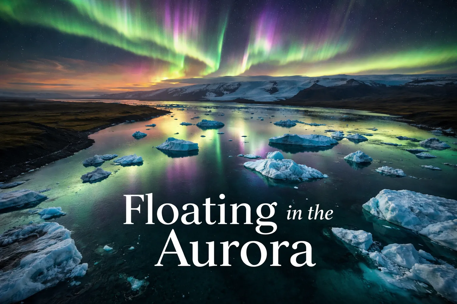
At Jökulsárlón, the aerial perspective transforms the scene into something almost abstract: hundreds of icebergs drifting in slow procession toward the sea, each one reflecting green and violet light from above, surrounded by absolute darkness. From the ground, you see perhaps a dozen icebergs and a strip of sky. From 160 meters, you see the entire lagoon as a single glowing organism. The scale becomes comprehensible — and cinematic — in a way it simply isn’t from the shore.
At Kirkjufell mountain on the Snæfellsnes Peninsula, the drone altitude reveals the mountain’s true conical geometry against the aurora bands. Kirkjufell is already a famous ground-level aurora shot, but from above at 200 meters, the waterfalls on its flanks catch the green light and the entire volcanic peninsula stretches out behind it into the North Atlantic. It’s one of those aerial perspectives that reconfigures your understanding of a place you thought you already knew. The best aurora borealis drone footage coming out of Iceland right now is overwhelmingly from this exact vantage — drone hovering at 180–220 meters, camera angled 30–45 degrees downward, Kirkjufell centered in the lower third with aurora filling the upper two-thirds of the frame.
Best Locations for Iceland Drone Photography Aurora
Jökulsárlón Glacier Lagoon
This is the single best location for iceland drone photography aurora in my experience. The combination of reflective water, floating ice, the diamond beach on the eastern shore, and open sky in all directions creates compositional possibilities that feel genuinely limitless. Fly at 120–180 meters, tilt the gimbal to 45 degrees downward, and you capture the entire lagoon with aurora wrapping from horizon to horizon. The nearest airport is Höfn (HFN), roughly 80km east — well outside controlled airspace. No significant restrictions apply to this location under standard ICETRA open-category rules.
Kirkjufell, Snæfellsnes Peninsula
Arguably the most iconic single subject in all of Icelandic aurora photography. From the air at 180–250 meters, the mountain’s perfect triangular silhouette becomes a compositional anchor. Fly from the parking area near Kirkjufellsfoss waterfall and climb slowly — the wind accelerates significantly above 150 meters on this exposed peninsula. Check ICETRA’s airspace map before flying; the Stykkishólmur area has some advisory zones but Kirkjufell itself is typically flyable. Best shot: drone hovering due south of the peak at 200 meters, gimbal at 30 degrees down, aurora filling the northern sky above.
Þingvellir National Park
Þingvellir sits directly on the Mid-Atlantic Ridge — the rift valley where North American and Eurasian tectonic plates are visibly pulling apart. From a drone at 250–300 meters, you can frame the entire rift valley with the aurora dancing overhead. This is one of photography’s great conceptual shots: geological time made visible from the air, lit by solar wind. Important note: Þingvellir is a UNESCO World Heritage Site, and while ICETRA rules apply, always verify current park-specific drone regulations with the Þingvellir National Park Authority before your visit, as rules can be updated seasonally.
Vík and Reynisfjara Black Sand Beach
The dramatic basalt columns of Reynisfjara and the sea stacks of Reynisdrangar create extraordinary aerial compositions. At 80–120 meters, the drone looks down on the black sand, the white surf lines, and the sea stacks while aurora fills the sky above. Avoid flying directly over the beach when people are present (a common restriction under ICETRA rules regarding uninvolved persons). The lava cliffs glow faintly green in strong aurora, creating one of those scenes that looks almost artificially composited — but isn’t.
Best Drone Aurora Photography Settings: The Technical Reality of Flying in the Dark
This is where most first-timers struggle, because best drone aurora photography settings are counterintuitive if you come from ground-based astrophotography. On a tripod, you might shoot 15–25 second exposures. On a hovering drone, any shutter speed beyond 3–4 seconds introduces motion blur from micro-vibration, GPS drift, and wind correction — and the aurora itself moves, so longer exposures smear the structure of the bands. Here’s the framework that works:
- ISO: 1600–6400 depending on aurora brightness. Start at 3200 and adjust. Modern sensors on the DJI Air 3S and Mavic 3 Classic handle ISO 3200 with acceptable noise for social media and even moderate print sizes. For brighter events (KP 5+), ISO 1600 is often sufficient.
- Shutter Speed: 2–4 seconds maximum. This is the critical constraint. A 2-second exposure on a stable drone in calm wind (under 15 km/h) produces sharp results. Push to 4 seconds only in very calm conditions with Sport Mode OFF and the drone in a GPS-locked hover. I target 2.5 seconds as my default starting point.
- Aperture: Maximum available (f/1.7 on DJI Air 3S wide lens; f/2.8 on Mavic 3 series). Always shoot wide open at night.
- White Balance: Manual, set to 3800–4200K. Auto white balance will fight you constantly and produce inconsistent colors between shots. Locking at 4000K gives aurora its natural green-to-violet gradient without warming casts.
- Shooting Format: RAW only. JPEG compression destroys the tonal range you need for aurora post-processing. Capture RAW and expose to the right of the histogram without blowing highlights.
- Drone Mode: Cine mode or Normal mode — never Sport. Reduce maximum speed and enable all stabilization. Hover for 30 seconds before shooting to let GPS lock settle.
Wind is the variable that determines everything. Above 30 km/h sustained wind, I bring the drone down. The drone is fighting the wind and its micro-corrections introduce blur. Iceland’s wind is unpredictable and can spike to dangerous levels rapidly — always monitor on-screen wind speed data and set a hard return threshold before you launch.
Battery life deserves serious attention in Icelandic winter conditions. Below -10°C, battery capacity can drop 30–40% from rated performance. I pre-warm batteries in an inside jacket pocket, carry four batteries minimum, and budget 12–15 minutes of actual flight time per battery in cold conditions rather than the rated 30+ minutes.
Can You Fly a Drone at Night in Iceland for Aurora Footage?
Yes — with important caveats. ICETRA (Samgöngustofa, the Icelandic Transport Authority) follows EASA-aligned open-category regulations, which do not impose a blanket ban on night flying for drones under 25kg in open-category subcategory A1/A3. However, visual line of sight (VLOS) is required at all times, which means night flying creates a practical and legal challenge: you must be able to see your drone. This is where strobe lights become not just useful but legally necessary for safe, compliant night operations.
The critical restrictions for drone flying northern lights iceland come down to these practical rules: stay outside 8km of airport reference points without authorization (crucial near Reykjavik/Keflavík), do not fly over uninvolved persons, stay below 120 meters above ground level in standard open-category operations, and always check ICETRA’s Digital Sky platform (icetra.is) for temporary restrictions (TFRs) that may be active. Most aurora photography locations in Iceland — Jökulsárlón, Kirkjufell, Reynisfjara, Þingvellir — are manageable within these rules. Avoid flying near Reykjavik’s urban core or within Keflavík’s control zone without specific authorization.
Timing Your Shot: KP Index, Moon Phase, and the Aurora Forecast
The aurora season in Iceland runs September through March, with the darkest nights and statistically most active aurora occurring October through February. The aurora forecast from the Icelandic Meteorological Office (vedur.is) is the single best resource for planning — it provides both cloud cover maps and a localized aurora forecast on a 0–9 scale updated every few hours. I recommend the Space Weather Prediction Center (NOAA) app for real-time KP index alerts.
The best aurora borealis drone footage comes from KP 3–5 events for Iceland’s latitude — these produce structured, photogenic bands rather than the diffuse glow that weak events generate. KP 5+ events produce dramatic curtain formations visible even through moderate cloud gaps. Moon phase matters differently for drone work than ground photography: a crescent moon illuminates glaciers and black sand just enough to add natural foreground detail without washing out the aurora in your frame. A full moon is actually workable for drone aurora — it lights the landscape beautifully, though the aurora needs to be KP 4+ to compete with the ambient lunar light.
Gear Worth Packing for Northern Lights Drone Photography Iceland
Flying in Iceland’s winter darkness at midnight requires purpose-built accessories — the wrong gear decisions cost you shots, batteries, and potentially your drone. Here’s what made a genuine difference in the field.
The STARTRC Neo 2 Lighted Landing Gear solved a problem I didn’t anticipate until my first night landing in Iceland: the drone becomes essentially invisible against a dark volcanic landscape from more than 30 meters away. These illuminated landing gear extensions do two things simultaneously — they raise the drone’s clearance above uneven lava rock and snow, protecting the gimbal from potentially catastrophic ground strikes, and their integrated LED lighting makes the drone visually trackable to distances that satisfy VLOS requirements during night operations. I learned the hard way that landing a drone on Iceland’s rough terrain without raised gear means one unlevel rock between a $1,200 gimbal assembly and disaster. The lights also serve as a passive orientation indicator — you can immediately read the drone’s attitude and heading from the ground even when the body is lost in darkness. For anyone flying a DJI Neo 2 in Iceland’s challenging terrain and night conditions, this is not optional equipment; it’s mission-critical.
The HeiyRC 2PCS Drone Strobe Night Light is the piece of gear that keeps your drone legally and practically visible during the extended night shoots that aurora photography demands. Under ICETRA regulations (aligned with EASA), maintaining visual line of sight is a non-negotiable requirement — and a drone without anti-collision lighting at 200 meters against a dark sky on a moonless night is simply invisible, creating both a safety hazard and a regulatory violation. These rechargeable FAA-compliant strobes are compatible with the full DJI lineup including the Air 3S, Mavic 3, and Mini 4 Pro, clip on securely without affecting flight dynamics, and strobe at a rate that’s easy to track against the star field and aurora. I had a close call on my second Iceland trip when a gust pushed my drone sideways during an aurora burst and I lost spatial orientation for a few seconds — the strobe’s rhythmic flash was what allowed me to reacquire the drone’s position and orientation instantly. At Jökulsárlón at 1 AM with no other light source for miles, these strobes are the difference between a successful shoot and a lost drone at the bottom of a glacial lagoon.
The STARTRC PHOTO LED Night Flight Assist Light for DJI Mini 4 Pro addresses a specific operational need that strobe lights alone don’t cover: illuminating the immediate area around your landing and launch zone. When you’re operating from a black sand beach at Reynisfjara at midnight, you’re launching from a surface you can barely see, surrounded by obstacles your drone’s sensors struggle to detect in low light. This searchlight-style LED assist light floods the area immediately below the drone during descent, allowing you to identify hazards — rocks, ice patches, unexpected terrain changes — that would otherwise be invisible until the gimbal made contact with them. The emergency flasher mode also serves as a ground-based signal if you need to help a search party locate your position in a worst-case scenario — not an irrelevant consideration when you’re solo on a remote Icelandic beach in February. For Mini 4 Pro operators specifically, the integrated design keeps additional weight minimal while meaningfully expanding the drone’s operational safety envelope in Iceland’s dark, complex terrain.
Frequently Asked Questions About Northern Lights Drone Photography Iceland
Drone Flight Brief: Aurora Photography Iceland at a Glance
Primary Locations Jökulsárlón (64.0784° N, 16.2306° W), Kirkjufell (64.9269° N, 23.3063° W), Þingvellir (64.2559° N, 21.1302° W), Vík (63.4193° N, 19.0070° W) Recommended Altitude Range 80–300 meters (vary by composition — icebergs: 120–180m; Kirkjufell: 150–250m; black sand beaches: 80–120m) Best Time to Fly 10 PM – 2 AM local time during active aurora events (KP index 3+) Best Season September through March; peak aurora activity October–February Regulations Summary ICETRA (Icelandic Transport Authority) governs drone flight. Standard open-category rules apply: stay below 120m in most areas, do not fly within 8km of airports without authorization, no flight over uninvolved people. Most aurora photography locations fall outside restricted zones. No specific night-flight ban in open category but visual line of sight required — use strobe lights. Þingvellir National Park: check current ICETRA/park authority rules before flying. Skill Level Required Advanced — cold weather, wind, low visibility, and long-exposure night technique combine to make this one of the most technically demanding drone scenarios KP Index Minimum KP 3 for faint aurora; KP 5+ for dramatic curtain displays visible at lower latitudes within Iceland Moon Phase New moon or crescent ideal — a full moon washes out faint auroras but can add foreground illumination for glaciers
What Northern Lights Drone Photography Iceland Reveals That Ground Cameras Never Can
| Primary Locations | Jökulsárlón (64.0784° N, 16.2306° W), Kirkjufell (64.9269° N, 23.3063° W), Þingvellir (64.2559° N, 21.1302° W), Vík (63.4193° N, 19.0070° W) |
| Recommended Altitude Range | 80–300 meters (vary by composition — icebergs: 120–180m; Kirkjufell: 150–250m; black sand beaches: 80–120m) |
| Best Time to Fly | 10 PM – 2 AM local time during active aurora events (KP index 3+) |
| Best Season | September through March; peak aurora activity October–February |
| Regulations Summary | ICETRA (Icelandic Transport Authority) governs drone flight. Standard open-category rules apply: stay below 120m in most areas, do not fly within 8km of airports without authorization, no flight over uninvolved people. Most aurora photography locations fall outside restricted zones. No specific night-flight ban in open category but visual line of sight required — use strobe lights. Þingvellir National Park: check current ICETRA/park authority rules before flying. |
| Skill Level Required | Advanced — cold weather, wind, low visibility, and long-exposure night technique combine to make this one of the most technically demanding drone scenarios |
| KP Index Minimum | KP 3 for faint aurora; KP 5+ for dramatic curtain displays visible at lower latitudes within Iceland |
| Moon Phase | New moon or crescent ideal — a full moon washes out faint auroras but can add foreground illumination for glaciers |
Ground-level aurora photography is extraordinary. But it presents a fundamental compositional problem: you are always looking up at the lights while simultaneously trying to include interesting foreground. The aurora and the landscape exist in tension with each other in the frame. From a drone at 150–250 meters, that tension dissolves completely. The aurora becomes context — it wraps around you, above and partially below as it reflects off water surfaces and glacial ice — while the landscape unfolds as a map beneath you.
At Jökulsárlón, the aerial perspective transforms the scene into something almost abstract: hundreds of icebergs drifting in slow procession toward the sea, each one reflecting green and violet light from above, surrounded by absolute darkness. From the ground, you see perhaps a dozen icebergs and a strip of sky. From 160 meters, you see the entire lagoon as a single glowing organism. The scale becomes comprehensible — and cinematic — in a way it simply isn’t from the shore.
At Kirkjufell mountain on the Snæfellsnes Peninsula, the drone altitude reveals the mountain’s true conical geometry against the aurora bands. Kirkjufell is already a famous ground-level aurora shot, but from above at 200 meters, the waterfalls on its flanks catch the green light and the entire volcanic peninsula stretches out behind it into the North Atlantic. It’s one of those aerial perspectives that reconfigures your understanding of a place you thought you already knew. The best aurora borealis drone footage coming out of Iceland right now is overwhelmingly from this exact vantage — drone hovering at 180–220 meters, camera angled 30–45 degrees downward, Kirkjufell centered in the lower third with aurora filling the upper two-thirds of the frame.
Best Locations for Iceland Drone Photography Aurora
Jökulsárlón Glacier Lagoon
This is the single best location for iceland drone photography aurora in my experience. The combination of reflective water, floating ice, the diamond beach on the eastern shore, and open sky in all directions creates compositional possibilities that feel genuinely limitless. Fly at 120–180 meters, tilt the gimbal to 45 degrees downward, and you capture the entire lagoon with aurora wrapping from horizon to horizon. The nearest airport is Höfn (HFN), roughly 80km east — well outside controlled airspace. No significant restrictions apply to this location under standard ICETRA open-category rules.
Kirkjufell, Snæfellsnes Peninsula
Arguably the most iconic single subject in all of Icelandic aurora photography. From the air at 180–250 meters, the mountain’s perfect triangular silhouette becomes a compositional anchor. Fly from the parking area near Kirkjufellsfoss waterfall and climb slowly — the wind accelerates significantly above 150 meters on this exposed peninsula. Check ICETRA’s airspace map before flying; the Stykkishólmur area has some advisory zones but Kirkjufell itself is typically flyable. Best shot: drone hovering due south of the peak at 200 meters, gimbal at 30 degrees down, aurora filling the northern sky above.
Þingvellir National Park
Þingvellir sits directly on the Mid-Atlantic Ridge — the rift valley where North American and Eurasian tectonic plates are visibly pulling apart. From a drone at 250–300 meters, you can frame the entire rift valley with the aurora dancing overhead. This is one of photography’s great conceptual shots: geological time made visible from the air, lit by solar wind. Important note: Þingvellir is a UNESCO World Heritage Site, and while ICETRA rules apply, always verify current park-specific drone regulations with the Þingvellir National Park Authority before your visit, as rules can be updated seasonally.
Vík and Reynisfjara Black Sand Beach
The dramatic basalt columns of Reynisfjara and the sea stacks of Reynisdrangar create extraordinary aerial compositions. At 80–120 meters, the drone looks down on the black sand, the white surf lines, and the sea stacks while aurora fills the sky above. Avoid flying directly over the beach when people are present (a common restriction under ICETRA rules regarding uninvolved persons). The lava cliffs glow faintly green in strong aurora, creating one of those scenes that looks almost artificially composited — but isn’t.
Best Drone Aurora Photography Settings: The Technical Reality of Flying in the Dark
This is where most first-timers struggle, because best drone aurora photography settings are counterintuitive if you come from ground-based astrophotography. On a tripod, you might shoot 15–25 second exposures. On a hovering drone, any shutter speed beyond 3–4 seconds introduces motion blur from micro-vibration, GPS drift, and wind correction — and the aurora itself moves, so longer exposures smear the structure of the bands. Here’s the framework that works:
- ISO: 1600–6400 depending on aurora brightness. Start at 3200 and adjust. Modern sensors on the DJI Air 3S and Mavic 3 Classic handle ISO 3200 with acceptable noise for social media and even moderate print sizes. For brighter events (KP 5+), ISO 1600 is often sufficient.
- Shutter Speed: 2–4 seconds maximum. This is the critical constraint. A 2-second exposure on a stable drone in calm wind (under 15 km/h) produces sharp results. Push to 4 seconds only in very calm conditions with Sport Mode OFF and the drone in a GPS-locked hover. I target 2.5 seconds as my default starting point.
- Aperture: Maximum available (f/1.7 on DJI Air 3S wide lens; f/2.8 on Mavic 3 series). Always shoot wide open at night.
- White Balance: Manual, set to 3800–4200K. Auto white balance will fight you constantly and produce inconsistent colors between shots. Locking at 4000K gives aurora its natural green-to-violet gradient without warming casts.
- Shooting Format: RAW only. JPEG compression destroys the tonal range you need for aurora post-processing. Capture RAW and expose to the right of the histogram without blowing highlights.
- Drone Mode: Cine mode or Normal mode — never Sport. Reduce maximum speed and enable all stabilization. Hover for 30 seconds before shooting to let GPS lock settle.
Wind is the variable that determines everything. Above 30 km/h sustained wind, I bring the drone down. The drone is fighting the wind and its micro-corrections introduce blur. Iceland’s wind is unpredictable and can spike to dangerous levels rapidly — always monitor on-screen wind speed data and set a hard return threshold before you launch.
Battery life deserves serious attention in Icelandic winter conditions. Below -10°C, battery capacity can drop 30–40% from rated performance. I pre-warm batteries in an inside jacket pocket, carry four batteries minimum, and budget 12–15 minutes of actual flight time per battery in cold conditions rather than the rated 30+ minutes.
Can You Fly a Drone at Night in Iceland for Aurora Footage?
Yes — with important caveats. ICETRA (Samgöngustofa, the Icelandic Transport Authority) follows EASA-aligned open-category regulations, which do not impose a blanket ban on night flying for drones under 25kg in open-category subcategory A1/A3. However, visual line of sight (VLOS) is required at all times, which means night flying creates a practical and legal challenge: you must be able to see your drone. This is where strobe lights become not just useful but legally necessary for safe, compliant night operations.
The critical restrictions for drone flying northern lights iceland come down to these practical rules: stay outside 8km of airport reference points without authorization (crucial near Reykjavik/Keflavík), do not fly over uninvolved persons, stay below 120 meters above ground level in standard open-category operations, and always check ICETRA’s Digital Sky platform (icetra.is) for temporary restrictions (TFRs) that may be active. Most aurora photography locations in Iceland — Jökulsárlón, Kirkjufell, Reynisfjara, Þingvellir — are manageable within these rules. Avoid flying near Reykjavik’s urban core or within Keflavík’s control zone without specific authorization.
Timing Your Shot: KP Index, Moon Phase, and the Aurora Forecast
The aurora season in Iceland runs September through March, with the darkest nights and statistically most active aurora occurring October through February. The aurora forecast from the Icelandic Meteorological Office (vedur.is) is the single best resource for planning — it provides both cloud cover maps and a localized aurora forecast on a 0–9 scale updated every few hours. I recommend the Space Weather Prediction Center (NOAA) app for real-time KP index alerts.
The best aurora borealis drone footage comes from KP 3–5 events for Iceland’s latitude — these produce structured, photogenic bands rather than the diffuse glow that weak events generate. KP 5+ events produce dramatic curtain formations visible even through moderate cloud gaps. Moon phase matters differently for drone work than ground photography: a crescent moon illuminates glaciers and black sand just enough to add natural foreground detail without washing out the aurora in your frame. A full moon is actually workable for drone aurora — it lights the landscape beautifully, though the aurora needs to be KP 4+ to compete with the ambient lunar light.
Gear Worth Packing for Northern Lights Drone Photography Iceland
Flying in Iceland’s winter darkness at midnight requires purpose-built accessories — the wrong gear decisions cost you shots, batteries, and potentially your drone. Here’s what made a genuine difference in the field.
The STARTRC Neo 2 Lighted Landing Gear solved a problem I didn’t anticipate until my first night landing in Iceland: the drone becomes essentially invisible against a dark volcanic landscape from more than 30 meters away. These illuminated landing gear extensions do two things simultaneously — they raise the drone’s clearance above uneven lava rock and snow, protecting the gimbal from potentially catastrophic ground strikes, and their integrated LED lighting makes the drone visually trackable to distances that satisfy VLOS requirements during night operations. I learned the hard way that landing a drone on Iceland’s rough terrain without raised gear means one unlevel rock between a $1,200 gimbal assembly and disaster. The lights also serve as a passive orientation indicator — you can immediately read the drone’s attitude and heading from the ground even when the body is lost in darkness. For anyone flying a DJI Neo 2 in Iceland’s challenging terrain and night conditions, this is not optional equipment; it’s mission-critical.
The HeiyRC 2PCS Drone Strobe Night Light is the piece of gear that keeps your drone legally and practically visible during the extended night shoots that aurora photography demands. Under ICETRA regulations (aligned with EASA), maintaining visual line of sight is a non-negotiable requirement — and a drone without anti-collision lighting at 200 meters against a dark sky on a moonless night is simply invisible, creating both a safety hazard and a regulatory violation. These rechargeable FAA-compliant strobes are compatible with the full DJI lineup including the Air 3S, Mavic 3, and Mini 4 Pro, clip on securely without affecting flight dynamics, and strobe at a rate that’s easy to track against the star field and aurora. I had a close call on my second Iceland trip when a gust pushed my drone sideways during an aurora burst and I lost spatial orientation for a few seconds — the strobe’s rhythmic flash was what allowed me to reacquire the drone’s position and orientation instantly. At Jökulsárlón at 1 AM with no other light source for miles, these strobes are the difference between a successful shoot and a lost drone at the bottom of a glacial lagoon.
The STARTRC PHOTO LED Night Flight Assist Light for DJI Mini 4 Pro addresses a specific operational need that strobe lights alone don’t cover: illuminating the immediate area around your landing and launch zone. When you’re operating from a black sand beach at Reynisfjara at midnight, you’re launching from a surface you can barely see, surrounded by obstacles your drone’s sensors struggle to detect in low light. This searchlight-style LED assist light floods the area immediately below the drone during descent, allowing you to identify hazards — rocks, ice patches, unexpected terrain changes — that would otherwise be invisible until the gimbal made contact with them. The emergency flasher mode also serves as a ground-based signal if you need to help a search party locate your position in a worst-case scenario — not an irrelevant consideration when you’re solo on a remote Icelandic beach in February. For Mini 4 Pro operators specifically, the integrated design keeps additional weight minimal while meaningfully expanding the drone’s operational safety envelope in Iceland’s dark, complex terrain.