
Giants Causeway Drone Photography Northern Ireland: What You See at Altitude Changes Everything
The first time I lifted my drone above the Giant’s Causeway, I genuinely stopped breathing for a second. I’d walked those basalt columns the day before — crouching between them, tracing hexagonal edges with my fingers, trying to comprehend 60 million years of volcanic history at ground level. But from 80 metres up, everything I’d failed to understand from the ground suddenly snapped into perfect, almost unsettling clarity. Giants causeway drone photography northern ireland is one of those rare specialities in aerial work where the subject only makes complete visual sense from above. The hexagonal tessellation stretches from the cliff base into the grey-green North Atlantic like an enormous tiled floor designed by a geometry obsessive — and from the air, you finally understand why early Irish mythology insisted a giant must have built it. No natural process, the human brain insists, could produce something this regular. And yet it did.
Drone Flight Brief: Giant’s Causeway Aerial Photography at a Glance
| GPS Coordinates | 55.2408° N, 6.5116° W (main causeway platform) |
| Recommended Altitude Range | 60–120m for pattern detail; 150–200m for full coastal context |
| Best Time of Day | Sunrise (approx. 05:00–07:00 BST in summer) for low-angle shadow detail in the hexagonal gaps |
| Best Season | November–February for low winter sun, dramatic Atlantic swell, and thinner crowds |
| Drone Regulations Summary | CAA UK rules apply (Drone and Model Aircraft Code). The Giant’s Causeway is a National Trust managed UNESCO World Heritage Site — commercial and recreational drone flight requires advance written permission from National Trust Northern Ireland. Flying without permission is a violation of both site rules and potentially CAA Operational Authorisation requirements. Do not assume open-access flying is permitted. |
| Airspace Classification | Uncontrolled airspace (Class G) — no NATS restriction at the causeway itself, but always verify via NATS drone assist or the UK CAA Drone Safe app before flying |
| Skill Level Required | Advanced — coastal winds, salt spray, unpredictable Atlantic gusts, and restricted fly zones demand confident, experienced drone handling |
| Nearest Town | Bushmills, Co. Antrim (3km) |
Giants Causeway Aerial View: What the Hexagonal Columns Reveal From Above
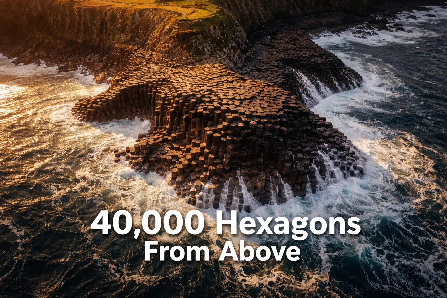
Walking the Giant’s Causeway gives you a tactile, close-up experience of the basalt columns — but it actively hides the most extraordinary thing about them. The human eye at ground level can see perhaps 20 or 30 columns at once. From a drone at 80 metres, you can see the entire causeway platform: roughly 40,000 columns forming a continuous, locked tessellation that extends approximately 150 metres out from the base of the cliffs into the Atlantic. The basalt columns from above drone perspective reveals something geologists call “columnar jointing” at a scale that’s simply impossible to perceive while standing on it — the way identical-width fractures radiate uniformly across the entire platform, the result of molten basalt cooling and contracting at an extraordinarily consistent rate approximately 50–60 million years ago.
What surprised me most on my first flight was the colour differentiation. The central columns, perpetually washed by the tide, are dark charcoal — almost black when wet. The higher columns closer to the cliff base dry out between tides and shift toward deep grey-brown. From 100 metres up during an incoming tide, you can watch the Atlantic slide across the hexagonal surface in thin sheets of white foam, filling each column gap sequentially, turning the geological pattern into something that briefly resembles a living circuit board. The giants causeway aerial view hexagonal columns effect is most dramatic in this window — approximately 90 minutes before high tide — when moving water emphasises every crack and joint in the platform.
The cliff profile is equally revelatory from the air. From the causeway path at ground level, the cliff face looks like a rough basalt wall. From 60–80 metres altitude with the drone positioned out over the sea looking back toward the coast, those cliffs reveal themselves as perfectly vertical organ-pipe columns — the same hexagonal structures, now oriented horizontally, stacked into columns 12 metres tall. This is the formation locals call “The Organ,” and from a side-profile drone perspective at approximately cliff-top height, it looks genuinely architectural — like a pipe organ hewn from the living rock.
The Best Aerial Shots to Capture: Compositions for Drone Photography at the Giant’s Causeway
The Top-Down Tessellation Shot
This is the defining image of giants causeway drone photography northern ireland — straight down, nadir position, at 60–90 metres, centred on the broadest section of the causeway platform. In low winter light, the hexagonal gaps cast individual shadows that turn the platform into a textured relief map. Shoot in RAW, bracket your exposure, and wait for a wave to partially cover the platform for that circuit-board effect. The best compositions include one or two human figures on the causeway for scale — the columns are typically 15–50cm across, and without a scale reference the nadir shot loses its sense of wonder.
The Causeway-Meets-Atlantic Wide Shot
Position the drone at 120–150 metres, angled at roughly 45 degrees, looking northeast along the coast with the causeway in the foreground and the Antrim plateau cliffs stretching to the right. This is the shot that communicates the full drama of drone photography northern ireland coast — the geometric order of the causeway contrasting with the organic chaos of the breaking Atlantic, with the dark volcanic cliffs rising behind. On days with southwest wind driving large swell, the wave spray hitting the outer columns creates a natural mist that softens the background beautifully.
The Organ Pipes Profile
Move the drone out over the sea to a position approximately 200 metres from the cliff face, at cliff-top height (roughly 100–110 metres above sea level here). The Organ formation — a fan of vertical basalt columns up to 12 metres tall — reads as a dramatic profile shot. Shoot in the hour before sunset when direct light rakes across the column faces from a low western angle, carving every vertical joint into high contrast. This is one of the most dramatic shots showing basalt columns from above drone perspective because you’re not actually above them — you’re level with the clifftop, looking across at the full column height.
The Giant’s Boot and Wishing Chair Detail Shots
The lesser-photographed formations — the Giant’s Boot (a naturally carved basalt shape near the main platform), the Wishing Chair (a throne-like arrangement of columns), and the Giant’s Gate — are nearly invisible from the path but read clearly from 40–50 metres. These low-altitude detail shots require the most precise drone control given the proximity to rock and sea spray, but they reward patience with genuinely unusual images that most causeway photography never captures.
Can You Fly a Drone at the Giant’s Causeway? Regulations and the Honest Reality
This is where I have to be direct with you, because the internet is full of beautiful Giant’s Causeway drone footage accompanied by zero discussion of how it was legally obtained. The Giant’s Causeway is a UNESCO World Heritage Site managed by the National Trust for Northern Ireland. The National Trust has a blanket policy requiring advance written permission for any drone flight over its properties — recreational or commercial. This is separate from and in addition to UK Civil Aviation Authority rules under the Drone and Model Aircraft Code (2020), which apply to all drone operators in the UK regardless of location.
To fly legally, you need to: (1) hold a valid UK CAA Flyer ID and Operator ID (both free, obtained at register-drones.caa.co.uk); (2) contact the National Trust Northern Ireland directly in writing to request a specific filming permit, well in advance of your visit — email the Giant’s Causeway visitor centre or the National Trust NI regional office; and (3) carry written confirmation of permission when you fly. The airspace itself over the causeway is uncontrolled Class G — there’s no NATS flight restriction zone — but that doesn’t grant permission to fly over National Trust land. The two are entirely separate considerations.
The practical reality: if you arrive without a permit, the National Trust rangers and visitor centre staff will ask you not to fly. I’ve seen this happen. The site receives over 1 million visitors annually and National Trust staff are alert to drones. If you’re a commercial operator, budget several weeks for the permit process. For recreational photographers, the permission process is more informal but still required. If you cannot obtain permission, the most honest advice is to enjoy the causeway on foot and purchase licensed aerial footage from a National Trust-approved operator — there are several Northern Irish drone companies who hold standing permissions for the site.
The Causeway Coastal Route: Additional Drone Spots Beyond the Causeway
The Giant’s Causeway sits roughly midpoint along the Causeway Coastal Route — one of the most dramatic coastal drives in Europe — and for drone photography northern ireland coast, the surrounding locations are just as compelling and in some cases easier to access legally. Carrick-a-Rede rope bridge, approximately 8km west of the causeway, spans a 30-metre chasm between the mainland cliff and Carrick-a-Rede island. From 80 metres above, the rope bridge appears as a slender thread between two cliff edges with the turquoise-green Antrim Sea below — one of the most vertigo-inducing aerial compositions in the UK. Again, this is National Trust property, so the same permission requirements apply.
Dunluce Castle ruins, perched on a sea stack approximately 5km east of the causeway, are on a different land holding and may have different access requirements — verify with the Historic Environment Division (HED) Northern Ireland. From altitude, the castle ruins on their isolated basalt stack read as pure drama: roofless medieval walls on a sheer-sided rock surrounded by crashing Atlantic swells. The causeway coastal route drone spots between Ballycastle and Portrush offer approximately 40km of dramatic aerial opportunity for any photographer willing to do the regulatory groundwork properly.
Gear Worth Packing: Propellers and Equipment for Coastal Drone Flying
Flying on the North Antrim coast means accepting that your drone will work harder than almost anywhere else in Europe. Atlantic wind gusts here are unpredictable, salt-laden, and strong enough to stress propellers that would handle calmer inland flying without issue. After losing a prop to a sudden gust reversal on my second morning at the causeway — the drone snapped back hard against the wind, stressed one blade past its flex tolerance, and I was done for the day — I started carrying dedicated spares for every flight. The Bwine Drone Original Propellers for F7GIM (4-pack, Dark Grey & Orange) are the manufacturer-spec replacement props for the F7GIM platform, and that OEM specification matters enormously in coastal conditions. Aftermarket props with slightly different pitch or flex characteristics can introduce vibration that coastal turbulence amplifies — and vibration is the enemy of sharp aerial imagery. Having these in my bag means a five-minute field swap rather than a cancelled shoot, and at the causeway where light windows are short and conditions change fast, that matters more than it sounds.
If you’re flying a cinelifter or larger FPV setup for higher-end footage — which some professional operators use at locations like this for their ability to carry heavier payloads and resist wind more effectively than compact drones — propeller durability is even more critical. The Gemfan Cinelifter RC Propellers 1050 Reinforced Glass Fiber Nylon Props (10-inch, 3-blade, Black, 4-pack) are built specifically for the punishment that larger FPV rigs dish out, and the reinforced glass fiber nylon construction gives them a stiffness-to-weight ratio that handles coastal crosswinds without the flexing that softer props exhibit. Three-blade configurations on a 10-inch diameter give these props excellent authority — the drone responds crisply to inputs even when gusts are trying to push it off course. I’ve seen operators running these on macroquad builds over the Antrim coast specifically because the extra blade count maintains lift stability when one blade is momentarily fighting a gust the others aren’t. Pack at least one spare set per flying day.
For DJI Mavic Pro users — and the Mavic Pro remains one of the most popular platforms for serious travel aerial photography because of its portability and image quality — the quick-release prop system is both a convenience and a vulnerability in coastal conditions. The standard props can work loose slightly in turbulent air, and over water that’s a risk I won’t take. The Craznick 8331F Replacement Propellers for DJI Mavic Pro/Mavic Pro Platinum (8-pack, Quick-Release Low Noise) give you the low-noise advantage of the Platinum-spec blade profile while providing an 8-pack supply that means you have replacements for multiple failure scenarios in a single day. The 8331F blade profile specifically reduces high-frequency vibration compared to older Mavic Pro props, which translates directly to sharper stills and smoother video — particularly noticeable in the 4K footage where motion blur from prop vibration at 60m altitude over textured rock becomes visible in post. Carrying 8 props for a multi-day coastal shoot costs very little and has saved at least two full shooting days for me.
Best Conditions for Giants Causeway Drone Photography: When the Light and Sea Align
The best single condition for photographing the causeway from the air is low winter sun — specifically, a clear December or January morning when the sun rises at a shallow angle from the southeast and rakes directly across the hexagonal platform. At 08:00 in January, the sun is low enough that each column gap casts a defined shadow, turning the nadir shot from a flat graphic into a deeply textured geological portrait. The shadows read as dark lines emphasising every joint, and the overall effect is far more dramatic than the flatter summer light.
The second ideal condition is an incoming tide with a moderate Atlantic swell — roughly 1.5–2.5 metre wave height. Large enough to push spray across the outer columns, small enough that it doesn’t fully submerge the platform and obscure the hexagonal pattern. Checking tide tables (BBC Weather or MagicSeaweed for the North Antrim coast) and timing your flight window for the 60–90 minutes before high tide gives you moving water on the platform without losing the pattern. Wind below 15 knots from the southwest is the ideal flying condition — enough to push spray but not enough to compromise drone stability significantly. The North Antrim coast averages wind speeds of 15–20 knots year-round, so calm flying days are the exception rather than the rule. Check the Met Office Northern Ireland forecast the morning of your shoot and be prepared to abort.
This post contains affiliate links. As an Amazon Associate, I earn from qualifying purchases at no extra cost to you.
Frequently Asked Questions: Giant’s Causeway Drone Photography
Is drone flying allowed at the Giant’s Causeway?
Drone flying at the Giant’s Causeway is not automatically permitted. The site is managed by the National Trust Northern Ireland, which requires advance written permission for all drone flights — recreational and commercial — over its properties. In addition, all UK drone operators must hold a valid CAA Flyer ID and Operator ID. The airspace above the causeway is uncontrolled Class G, meaning there is no aviation-authority flight restriction, but National Trust land access rules are separate from airspace rules and must be satisfied independently. Contact the National Trust Northern Ireland directly to apply for a filming permit before visiting.
What is the best altitude for drone photography of the Giant’s Causeway hexagonal columns?
The best altitude for capturing the hexagonal column pattern in detail is 60–90 metres in nadir (straight-down) orientation. At this height, individual columns are clearly resolved and the full tessellation pattern across the causeway platform is visible in a single frame. For wide coastal context shots including the cliff profile and surrounding Atlantic, 120–180 metres provides the best balance of detail and scale. The Organ Pipes cliff formation is best photographed from approximately cliff-top altitude (100–110 metres above sea level) with the drone positioned out over the sea, giving a level side-profile view rather than a top-down view.
What are the biggest challenges for drone photography on the North Antrim coast?
The primary challenge is wind. The North Antrim coastline is exposed to open Atlantic weather systems, and wind speeds of 15–25