
This post contains affiliate links. As an Amazon Associate, I earn from qualifying purchases at no extra cost to you.
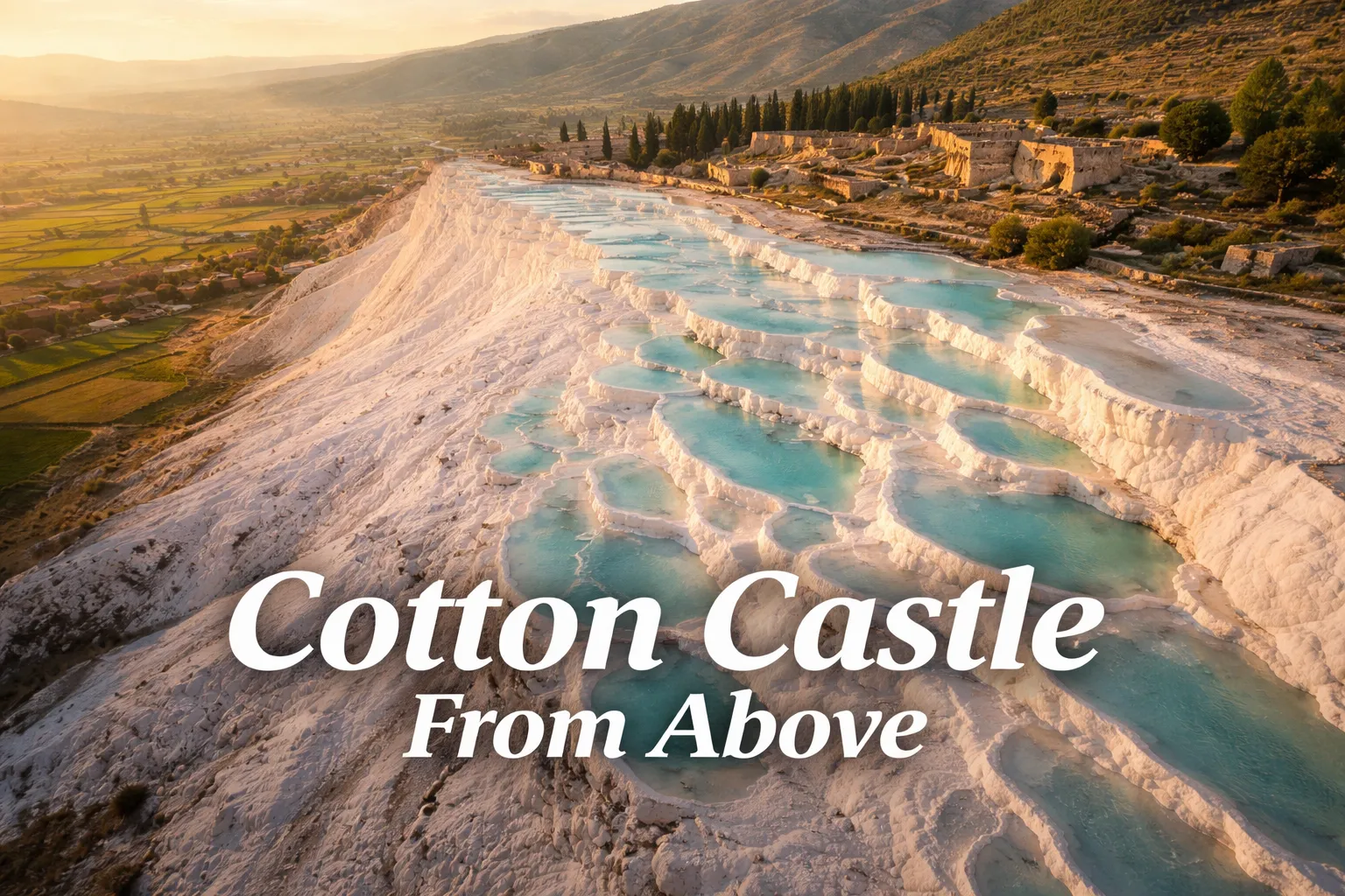
The moment my drone cleared the treeline and I tilted the camera down toward Pamukkale for the first time, I genuinely forgot to breathe. What looks like a strange white hillside from the road below transforms, from altitude, into something almost impossibly geometric — a cascading staircase of calcium pools stepping down a 200-meter cliff face, each terrace filled with water ranging from milky turquoise to deep mineral blue, all of it glowing against the dark green of the Çürüksu Valley. Pamukkale drone photography over Turkey’s thermal pools is unlike any other aerial subject I’ve shot. The textures, the color science, the ancient city sitting directly above — none of it fully registers until you’re looking straight down from 150 meters. If you’re planning to fly here, this guide is everything I wish I’d had before I landed in Denizli.
Drone Flight Brief: Pamukkale Aerial Photography Quick-Reference
Before we go any further, here’s the structured data every aerial photographer needs before flying Pamukkale. Read the regulations section in full before you make any decisions — this site is protected, and the rules are specific.
| GPS Coordinates (Main Terrace) | 37.9207° N, 29.1189° E |
| Recommended Altitude Range | 80–250 meters AGL for wide compositions; 40–80m for detail pool shots |
| Best Time of Day to Fly | Sunrise (6:00–7:30 AM local time) — low raking light, minimal crowds, pink-toned travertine |
| Best Season | April–May and September–October (mild temps, lower visitor numbers, ideal light quality) |
| Turkish SHGM Drone Regulations | Registration required via SHGM (Turkey’s civil aviation authority). Pamukkale falls within a UNESCO-protected zone with flight restrictions; commercial and recreational flights require prior authorization. Peak-hour flight bans apply. Full detail in the regulations section below. |
| Skill Level Required | Intermediate — thermal updrafts off warm water surface, variable wind off ridge, restricted airspace management |
| Nearest Airport (Controlled Airspace Ref) | Çardak Airport (DNZ), approximately 65 km from site |
What the Pamukkale Travertine From Above Actually Reveals
Ground-level visitors at Pamukkale experience the terraces as a series of individual pools — you walk the white calcium paths barefoot, peer down into one glowing basin at a time, and never quite grasp the full scale of the system. From above, the entire picture snaps into focus instantly. The travertine terraces from above read as a frozen waterfall, a perfectly organized cascade of concentric basins locked in calcium carbonate, each one slightly lower than the last, all of them connected by the same thermal water source pushing up from deep underground at a constant 35–36°C (95–97°F).
But the single most surprising thing the aerial view reveals — and the detail that genuinely stopped me mid-flight — is the ancient Roman city of Hierapolis sitting directly on the plateau above the terraces. At altitude, you can read the full urban grid: the colonnaded main street (the Plateia), the massive necropolis stretching north, the theatre carved into the hillside, the bath complexes positioned to exploit the thermal water. Hierapolis and Pamukkale are a UNESCO dual heritage site (natural and cultural), and from 200 meters, you understand exactly why. The white calcium cliffs and the red-stone Roman ruins share the same ridge, separated by only a few hundred meters, and no ground photo captures both simultaneously at true scale.
The aerial view also clarifies something that surprises most visitors: a significant portion of the terrace system is dried out or semi-active. Turkey’s tourism authority periodically reroutes water flow to allow sections to re-mineralize, meaning the brilliant white zones with full pools are only part of the hillside. From altitude, the contrast between fully active terraces (vivid blue water, white carbonate rims), semi-active sections (damp but poolless, cream-colored), and dormant zones (dry, grey-brown calcium) creates a natural gradient across the cliff face that’s invisible from the walking paths. Understanding this pattern before you arrive makes your shot selection dramatically better.
Pamukkale Terraces Aerial View: The Best Shots to Capture
After multiple sessions over this site, I’ve settled on five compositions that consistently produce the strongest results. The key to Pamukkale aerial photography is understanding that you’re working with both natural geometry and natural color — and the two don’t always align at the same altitude or angle.
The Top-Down Pool Pattern (80–120 Meters)
Drop the drone to 80–120 meters directly above the most active terrace section and point the gimbal straight down at 90 degrees. At this altitude, the individual pools fill the frame as abstract geometric shapes — irregular white-rimmed circles and crescents containing water in three or four distinct shades of blue simultaneously. The color variation is caused by differences in mineral concentration, water depth, and sediment suspension, and it’s only visible from directly above. This is the shot that performs best on social media and in print, because it reads as almost surreal — like looking down at a stained-glass window.
The Sunrise Cascade Shot (150–200 Meters, 45-Degree Angle)
Position the drone to the east of the terraces at 150–200 meters, angled at roughly 45 degrees back toward the cliff face, in the first 30 minutes after sunrise. The low-angle morning light rakes across the travertine horizontally, throwing every calcium ridge into sharp relief and warming the white carbonate to a pink-gold tone that midday light simply cannot produce. The pale blue pools glow against the warm white in a color contrast that’s extraordinary. Include the valley below in the lower third of the frame — the dark green farmland against the white cliffs is the scale anchor that makes this shot work.
Hierapolis and the Terraces in One Frame (220–250 Meters)
This is the technically demanding shot but the most historically significant. At 220–250 meters, positioned to the southwest, you can fit both the full terrace cascade and the visible Roman street grid of Hierapolis in a single wide frame. The red-stone ruins on the plateau above and the brilliant white-blue terraces below create a color contrast that tells the whole UNESCO story in one image. Fly here before 8 AM — the theatre casts strong morning shadow that adds depth to the ruin structures, and the terrace pools are at their most vivid before tourist foot traffic disturbs the sediment.
The Thermal Source Wide Shot (150 Meters, Northward Facing)
Position north of the plateau and angle south to include the visible thermal river channel that feeds the terrace system. This reveals something most visitors never think about: there’s a continuous warm-water source flowing across the plateau surface before it cascades down the cliff. At certain times of year, you can see the steam rising from the channel visible even in still images as a slight atmospheric haze. This shot works best in cooler months — October through March — when the temperature differential between the 35°C water and ambient air produces the most visible mist.
Can You Fly a Drone at Pamukkale? Turkey SHGM Regulations Explained
This is the section you need to read carefully. Pamukkale drone photography is subject to multiple overlapping regulatory layers, and the honest answer to “can you fly here?” is: it depends on how you approach it, and cutting corners is a genuinely bad idea at a UNESCO site with active cultural heritage enforcement.
Turkey’s civil aviation authority, the SHGM (Sivil Havacılık Genel Müdürlüğü), requires all drones — commercial and recreational — to be registered in the national drone registration system before any flight. Foreign visitors with foreign-registered drones still need to comply with Turkish airspace regulations under SHGM rules, and Pamukkale falls within a zone that requires specific authorization due to its UNESCO dual heritage status and proximity to the protected archaeological site of Hierapolis.
Practically, this means several things. First, peak-hour flight restrictions apply — flying over the terrace walking areas during operating hours (roughly 8 AM to 7 PM in summer) is restricted to prevent interference with visitors and to protect the terrace surface, which is genuinely fragile calcium carbonate. Second, the Ministry of Culture and Tourism has jurisdiction over the Hierapolis archaeological zone, meaning drone flights over the ruins require a separate permit from the ministry — not just SHGM registration. Third, local enforcement varies, but the site has park rangers and UNESCO monitoring, and foreign visitors found flying without authorization risk equipment confiscation and fines.
The best legal path for serious aerial photographers is to contact the Pamukkale National Park administration and the SHGM at least 4–6 weeks before your visit to apply for flight authorization. Many professional photographers also work through a Turkish fixer or production company with existing ministry relationships. Sunrise flights (before the park officially opens to foot traffic) are the window most authorized photographers use — the light is best, the terraces are empty, and the authorization process for pre-opening hours is more straightforward. Do not fly here without authorization. The cultural heritage protection laws in Turkey carry real penalties, and the site deserves better than unauthorized overflight.
Cotton Castle Turkey Drone Photography: Understanding the Color Science
One of the most technically interesting aspects of Pamukkale aerial photography is understanding why the water changes color across the terrace system — and using that knowledge intentionally in your shot selection. The “cotton castle Turkey” name comes from the white travertine, but the real visual magic in the aerial view is the water’s shifting blue palette.
The color variation has three main causes. First, water depth: shallow pools (under 30 cm) appear pale milky turquoise because suspended calcium carbonate particles scatter light back toward the surface before it can penetrate. Deeper pools (60 cm and above) absorb more red wavelengths and reflect blue, appearing a clear, deeper cyan. Second, mineral concentration: pools in the active terrace zone with higher dissolved mineral content have a slightly milky, opaque quality — they look like liquid chalk. Pools near the edges of the active zone, where the water is slightly cooler and less saturated, run clearer and bluer. Third, angle of light relative to the camera: in the hour after sunrise, raking light hitting the pool surface at a low angle creates strong specular highlights on the rippled water surface. By mid-morning with light overhead, the pools appear flatter and more uniformly blue. This is why ND filters are non-negotiable — you need control over your shutter speed to manage both the highlights off white travertine and the color depth in the water simultaneously.
Turkey Drone Photography Hot Springs: Gear Worth Packing
Flying over thermal water in bright mountain light creates one of the most demanding exposure environments in aerial photography. The combination of brilliant white travertine, specular highlights off pool surfaces, and deeply saturated blue water means your drone’s auto-exposure is constantly fighting itself. These are the three pieces of gear I now consider non-negotiable for Pamukkale and similar hot spring aerial subjects.
If you’re flying a DJI Mini 3 or Mini 3 Pro, the NEEWER ND Filter Set for DJI Mini 3 / Mini 3 Pro (6 Pack — CPL, ND8, ND16, ND32, ND64, ND128) is the filter kit I’d pack first for Pamukkale. The challenge at this location is the extreme brightness range — you’re shooting a subject that combines mirror-bright white calcium carbonate with dark blue water, often against a bright sky. Without filters, the drone’s sensor is forced to choose between blowing out the white travertine or blocking up the shadow detail in the pool interiors, and it usually loses on both. I reached for the ND64 during the mid-morning window when the terraces were fully lit and the sun angle was steep, and it gave me the shutter control I needed to keep motion blur out of the water while retaining full color depth in the pools. The CPL is equally valuable — polarizing light off the water surface reveals the pool floor structure and intensifies the blue saturation in a way that no amount of post-processing can fully replicate. Six filters in a compact case means you’re covered from golden hour (ND8) all the way to full midday sun (ND128), which matters when your authorized flight window might span multiple light conditions.
For those flying the DJI Mini 4K, Mini 2, Mini SE, Mavic, or Mini 2 SE, the NEEWER 6 Pack ND Filter Set with Snap-On CPL, UV, ND4/ND8/ND16/ND32 (FL-B31) is the kit designed specifically for your sensor stack, and the snap-on mount design matters more than you’d think in the field at Pamukkale. When you’re working a pre-sunrise authorized window with limited time before the park opens, swapping filters needs to be fast, one-handed, and done without removing the gimbal cover — the snap-on system handles all of that. The multi-coated HD glass construction is important here specifically because thermal air rising off warm pool water can create subtle atmospheric shimmer at lower altitudes, and cheap filter glass with coating irregularities will amplify that shimmer into visible softness. These filters maintain edge-to-edge sharpness even at the 40–80 meter low-altitude pool detail shots where optical quality is most critical. The UV filter also serves as a permanent gimbal protector when you’re walking the site with the drone in your backpack — the dusty travertine paths shed fine calcium particles that are exactly the kind of abrasive debris you don’t want near an unprotected lens.
For DJI Mavic 4 Pro pilots, the STARTRC ND/CPL Filter Set for DJI Mavic 4 Pro (4 Pack — ND8/32/64/CPL) is built around the Mavic 4 Pro’s larger sensor and wider aperture range, and those specs matter specifically at Pamukkale’s thermal environment. The Mavic 4 Pro’s 1-inch-class sensor captures significantly more dynamic range than smaller sensors, but that advantage disappears if you’re not controlling shutter speed with appropriate ND filtration — the sensor will simply overexpose highlights faster. The aluminum frame construction resists the thermal expansion and contraction that happens when you fly from cool morning air down toward the warm water surface and back, which I’ve seen cause cheaper plastic-framed filters to develop a slight wobble on the mount mid-flight. The ND64 in this set is the workhorse for Pamukkale’s midday sessions, and the CPL cuts through the surface glare on the pools to reveal the layered color depth that makes the Mavic 4 Pro’s color science truly shine. Four filters rather than six keeps the kit lighter without sacrificing the range you actually need at this location.
Frequently Asked Questions About Pamukkale Drone Photography
Is drone photography allowed at Pamukkale UNESCO site?
Drone photography at Pamukkale is not freely permitted — it requires authorization from Turkey’s SHGM (civil aviation authority) and, for flights over the Hierapolis archaeological zone, a separate permit from the Turkish Ministry of Culture and Tourism. Unauthorized drone flight over the site is prohibited and can result in equipment confiscation and fines. That said, authorized flights do occur regularly for commercial and professional purposes. The key is applying at least 4–6 weeks in advance, specifying your drone model, intended flight zones, and flight times. Pre-opening sunrise windows are the most commonly approved flight periods and also produce the best light for photography.
What is the best time of day for Pamukkale aerial photography?
The best time for Pamukkale drone photography is the first 60–90 minutes after sunrise. During this window, the low-angle light rakes across the travertine from the east, warming the white calcium carbonate to pink and gold tones while the pool water retains its deep blue-turquoise saturation. The terraces are empty of visitors, thermal haze is minimal (or beautifully misty in cooler months), and the contrast between the lit terrace faces and shaded pool interiors gives the aerial image strong three-dimensional depth. Midday light flattens the white terraces into a blown-out uniformity and creates harsh specular highlights on the water that are difficult to manage even with ND filtration.
What altitude produces the best drone shots of Pamukkale’s travertine terraces?
Different altitudes serve different compositions at Pamukkale.