
| GPS Coordinates | 17.3159° N, 87.5347° W (center of the hole) |
| Recommended Altitude Range | 200–400m for full circle composition; 60–120m for reef edge and color gradient detail |
| Best Time of Day to Fly | 9:00 AM – 11:30 AM local time (sun high enough to eliminate reef shadow, low enough to avoid noon bleach-out) |
| Best Season | Late November through April — dry season, calmer seas, clearer skies, minimal wind chop on the boat deck |
| Drone Regulations Summary | Drones must be registered with the Belize Department of Civil Aviation (DCA) before flight. Lighthouse Reef sits within Belize’s territorial waters. No specific no-fly zone covers the hole itself, but operators are required to comply with Belize’s Civil Aviation Regulations. Commercial aerial work requires an additional permit. Always check current DCA guidance before travel. |
| Skill Level Required | Advanced — boat-deck launch and recovery in open ocean, distance flying 100km offshore, limited GPS signal redundancy, wind exposure |
| Location Context | Part of Lighthouse Reef Atoll, ~100km east of Belize City, accessible only by liveaboard or day boat charter |
What the Great Blue Hole Aerial View Reveals That You Cannot See from the Surface
Jacques Cousteau sailed the Calypso into this hole in 1971 and declared it one of the top five diving destinations on Earth. He was working from the water’s surface and from below. What he could not fully perceive — what nobody could fully perceive before drone technology — is the geological storytelling that the aerial perspective makes completely legible. From above 300 meters, the Great Blue Hole aerial view communicates something that no diving experience, no boat deck vantage point, and no satellite image can quite replicate: you are looking at an ancient limestone cave ceiling that collapsed.
During the last ice age, when sea levels were roughly 120 meters lower than today, this location was dry land. A massive cave system formed in the limestone karst — stalactites still hang from its underwater walls at depth, which is what Cousteau’s divers found. As the glaciers melted and sea levels rose approximately 10,000–15,000 years ago, the cave flooded and its roof could no longer support itself. It collapsed inward, creating a perfectly circular sinkhole 318 meters wide and 124 meters deep. From the air, the geometry of that collapse is written clearly: the nearly perfect circle, the sharp boundary between the deep anoxic water inside (where almost no marine life exists and the color goes near-black) and the sunlit reef platform outside, and the surrounding atoll structure of Lighthouse Reef itself — a thin ribbon of coral surrounding a shallow lagoon, which is itself surrounded by deep ocean blue.
That concentric ring structure — deep navy center, mid-blue inner reef slope, bright turquoise reef flat, then open Caribbean — is only fully visible from altitude. At 250 meters and above on a clear morning, the entire atoll reads like a topographic map drawn in color. You can trace the reef walls, identify where the lagoon shallows out, and see exactly why the hole’s perfect circularity looks digitally artificial. This is the image that made the Great Blue Hole famous, and it only exists from above.
The Best Shots to Capture: Altitude, Angle, and Composition Guide
After multiple flights over the hole across two separate liveaboard trips, I’ve settled on three distinct shots that produce consistently exceptional results. Each targets a different story and requires a different altitude and camera angle.
The Bullseye Shot (250–400m, Straight Down)
This is the hero image — the one you’ve seen everywhere. The best altitude for the full-circle bullseye composition is 300–350 meters, with the gimbal at precisely 90 degrees nadir (straight down). At this altitude, the entire 318-meter diameter of the hole fits within the frame with reef context on all sides, giving the composition the concentric ring structure that makes it unmistakably the Great Blue Hole. Below 250 meters, you lose the outer reef context and the image reads as simply “dark water surrounded by blue.” Above 400 meters, atmospheric haze begins to soften the color contrast, and on anything less than a perfectly clear day, you’ll notice it. Fly at 300–350m on a clear morning, shoot in RAW, and you will have the image.
The Color Gradient Detail Shot (60–120m, 45–60 Degree Angle)
Lower altitude reveals the color transition in extraordinary detail — the exact line where turquoise reef flat becomes dark blue reef slope, and where reef slope becomes the near-black void of the hole interior. At 80 meters with a 45-degree gimbal angle, positioned over the northwestern rim of the hole, you capture the full color spectrum in a single diagonal sweep across the frame. This angle also picks up wave texture on the reef flat and any dive boats anchored at the rim, giving scale to the image that the high nadir shot lacks.
The Atoll Context Shot (400m+, Slight Tilt North)
For Lighthouse Reef drone photography, push altitude above 400 meters and tilt the gimbal slightly off nadir — roughly 75 degrees — looking northward across the atoll. At this altitude, you begin to capture the full reef ribbon of Lighthouse Reef surrounding its lagoon, with the Blue Hole visible as one feature within the broader atoll structure. This shot communicates the geological context: the hole is not a standalone feature but part of an entire reef ecosystem. Half-Moon Caye — a small island at the southern tip of Lighthouse Reef — becomes visible on clear days, adding a natural framing element to the lower portion of the frame.
Can You Fly a Drone at the Great Blue Hole? Regulations and Practical Reality
Let me be direct here, because this is the question I get most often about Belize Blue Hole drone footage and the answer deserves honesty rather than optimism. Belize does permit drone flight by visitors, but with specific requirements that many travelers ignore — and the consequences of ignoring them in a protected marine reserve area are not trivial.
The Belize Department of Civil Aviation (DCA) requires all drone operators to register their aircraft before flying in Belizean airspace. This applies to recreational and commercial operators alike. The registration process requires submitting documentation to the DCA and is not a day-of-arrival formality — start this process at least three to four weeks before your trip. For commercial aerial photography or videography (meaning you intend to use the footage professionally or sell it), an additional operational permit is required. The Great Blue Hole itself falls within the Belize Barrier Reef Reserve System, a UNESCO World Heritage Site, and while there is no blanket drone ban over the water, the area’s protected status means rangers and liveaboard operators will be watching. Several liveaboard operators have explicit no-drone policies aboard their vessels — verify this before booking if drone photography is your primary purpose.
Practically speaking, the real challenges at this location are logistical rather than regulatory. You are 100 kilometers offshore on a boat that is moving, rocking, and surrounded by salt water. Every launch and recovery happens from a wet deck. There are no emergency landing options — the reef flat is coral and the ocean is deep. This is not a location for drone beginners. Fly calm, fly deliberate, and always keep the drone within visual line of sight. I set a conservative battery return threshold of 40% at this location — getting the drone back to a moving boat in open water is not the time to discover you misjudged your battery margin.
Best Time to Photograph the Great Blue Hole From Above
The single most important variable for best drone shots Caribbean-quality imagery at the Great Blue Hole is sun angle. The color contrast that makes this location extraordinary — that deep navy center against turquoise reef — is a function of light penetration and water depth. When the sun is too low on the horizon, the shallow reef flat reads darker and the contrast between the hole and the reef collapses. When the sun is directly overhead at noon, you get glare patches and bleached highlights on the turquoise. The optimal window is 9:00 AM to 11:30 AM local time, when the sun is high enough to illuminate the reef flat fully but not yet producing the flat, washed-out quality of midday light.
For season, the dry season from late November through April is strongly preferred. During this period, Belize experiences its calmest weather, clearest skies, and least wind — all of which translate directly to stable boat decks, smooth drone flight, and maximum water visibility. The wet season (June through October) brings clouds, choppier seas, and the risk of tropical storm activity. A cloudy day over the Blue Hole produces a flat, low-contrast image that fails to capture the color drama that makes this location legendary. Chase the dry season window.
Gear Worth Packing for Great Blue Hole Drone Photography
Flying a drone from a dive boat 100 kilometers offshore in the Caribbean is one of the most gear-punishing aerial photography environments you will ever work in. Salt spray, boat vibration, high humidity, and the constant presence of water beneath and around every piece of equipment mean that your protective cases are not optional luxuries — they are the difference between a functioning drone and a very expensive paperweight. Here is what I travel with and why each piece earns its place in my bag.
The Jack Boss Hard Case (13.6 x 11.4 x 6 Inch, Black) has become my primary drone travel case for exactly this kind of remote marine expedition, and it earns its place for one specific reason: the customizable foam interior combined with a weather-resistant waterproof seal means I can configure it precisely around my drone body, controller, and spare batteries rather than accepting a generic layout that leaves components shifting in transit. On liveaboard trips where your gear spends multiple days in a damp, salt-air environment below deck, the quality of that seal is everything. I learned this the hard way on my first Caribbean trip when a generic pelican-style knockoff let moisture inside overnight — waking up to a condensation-fogged camera sensor an hour before the best morning light is a feeling I have no interest in repeating. The 13.6 x 11.4 x 6 inch interior is also well-sized for mid-range drones with their accessories without being so large that it becomes unwieldy on a crowded boat. At this location, where you will be loading and unloading gear from a rocking deck, a manageable case footprint genuinely matters.
If you are flying a DJI Mini 4 Pro or Mini 3 Pro — both excellent choices for this location given their compact size and 4K capability — the Lykus Titan MM410 Waterproof Hard Case is the most purpose-built solution I have found. What distinguishes it from generic waterproof cases is the specific engineering for the DJI Mini ecosystem: it supports up to 7 batteries in dedicated slots alongside the drone body and the RC2, RC, or RC-N1/N2 controller with a lanyard cutout, so everything is organized and retrievable under pressure rather than loose in cut foam. The scenario where this saves you is more common than you would think — at 5:30 AM on a liveaboard, in low light, with the boat rocking and the guide saying the light window opens in 20 minutes, the difference between a case where you can find everything immediately and one where you are rummaging is meaningful. The waterproof rating on the Lykus Titan is genuinely tested, not marketing copy — I have had this case take a wave wash on deck and the interior stayed dry. For a Mini platform flying over open ocean, that peace of mind is priceless.
For protecting spare memory cards, ND filter sets, and smaller accessories — the components that tend to get shoved into pockets or dry bags and forgotten until they are needed — the Ant Mag Waterproof Hard Case with Pick & Pluck Foam (9.2 x 6.5 x 2.7 inch interior) is the compact secondary case I now consider non-negotiable on any marine photography trip. The pick-and-pluck foam system means you can create exactly the cavities your specific components require — I’ve configured mine with slots for four ND filters, two 64GB cards, a USB-C charging cable, and a spare propeller set — and the waterproof hard shell protects everything even when the case gets kicked under a wet bench seat. The specific scenario where this earned my permanent loyalty: I was photographing a reef in strong wind and an unexpected wave broke over the gunwale, flooding the back deck. My drone case was sealed and fine. But a crew member’s open bag lost a GoPro and two filters overboard. Everything inside my Ant Mag case was completely unaffected. At this price point for full waterproof protection, it is one of the best value purchases in my entire kit.
Frequently Asked Questions
Is it legal to fly a drone over the Great Blue Hole in Belize?
Flying a drone over the Great Blue Hole is legal under Belizean aviation law, provided you comply with the registration requirements of the Belize Department of Civil Aviation (DCA). Drones must be registered with the DCA before flying in Belizean airspace — this applies to both recreational and commercial operators. The Great Blue Hole sits within the Belize Barrier Reef Reserve System UNESCO World Heritage Site, and while no blanket aerial ban exists over the water, visitors should be aware that many liveaboard operators who service this area have their own no-drone policies aboard their vessels. Always confirm with your charter operator before booking, begin your DCA registration process at least three to four weeks before travel, and if you intend to use footage commercially, apply for a separate commercial operations permit from the DCA.
What altitude produces the best drone photos of the Great Blue Hole?
The best altitude for the classic full-circle composition of the Great Blue Hole is 300–350 meters with the gimbal at 90 degrees nadir (straight down). At this altitude, the complete 318-meter diameter of the hole fits within the frame with sufficient reef context on all sides to show the full concentric ring color structure. For detail shots of the reef edge and color gradient, descend to 60–120 meters with a 45–60 degree gimbal angle. For a wider atoll context shot that shows the Blue Hole within the full structure of Lighthouse Reef, climb above 400 meters and tilt slightly off nadir looking northward. The 300–350 meter range is the definitive altitude for the image that made this location famous.
How do you get to the Great Blue Hole to fly a drone?
The Great Blue Hole is located within Lighthouse Reef Atoll, approximately 100 kilometers east of Belize City, and is accessible only by boat or small aircraft. The most practical option for drone photographers is a liveaboard dive vessel, which anchors at or near the Blue Hole overnight and gives you access during the optimal early morning light window. Day trips from Belize City or Ambergris Caye are possible via charter speedboat, but the three-plus hour transit each way significantly compresses your available flying time. Some operators fly small planes from Belize City to Lighthouse Reef’s airstrip at Half-Moon Caye — this approach reduces transit time but limits gear carrying capacity. Confirm with any operator that drone photography is permitted aboard their specific vessel before
This post contains affiliate links. As an Amazon Associate, I earn from qualifying purchases at no extra cost to you.
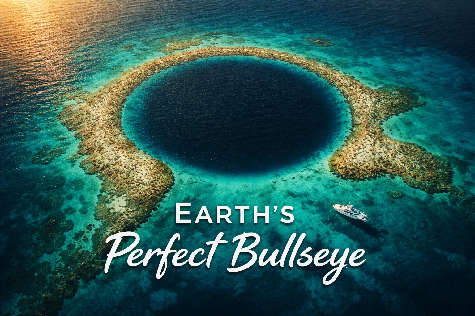
The moment the drone clears the gunwale of the dive boat and climbs past 50 meters, you already know something extraordinary is happening. The reef flat appears first — a shallow turquoise skirt fringing the atoll like lace on a tablecloth. Then, as the altitude ticks up toward 150 meters, the circle reveals itself. A near-perfect disc of deep, impossible navy blue, ringed by lighter cobalt, then turquoise, then the open Caribbean beyond. Your first reaction — I promise — is to question whether you’re looking at a render. Great Blue Hole drone photography in Belize produces images so geometrically flawless and so dramatically color-saturated that every single person who has ever seen my footage has asked me whether I edited the colors. I didn’t. The Great Blue Hole does that entirely on its own. This is what makes it arguably the single most iconic aerial photography subject in the entire Caribbean, and why travelling 100 kilometers offshore in a small boat to fly a drone from the deck is absolutely, completely worth it.
Great Blue Hole Drone Photography Belize: Flight Brief
Before we get into the experience and the composition strategies, here is the structured data you need for planning. Bookmark this section — it answers the fast questions.
| GPS Coordinates | 17.3159° N, 87.5347° W (center of the hole) |
| Recommended Altitude Range | 200–400m for full circle composition; 60–120m for reef edge and color gradient detail |
| Best Time of Day to Fly | 9:00 AM – 11:30 AM local time (sun high enough to eliminate reef shadow, low enough to avoid noon bleach-out) |
| Best Season | Late November through April — dry season, calmer seas, clearer skies, minimal wind chop on the boat deck |
| Drone Regulations Summary | Drones must be registered with the Belize Department of Civil Aviation (DCA) before flight. Lighthouse Reef sits within Belize’s territorial waters. No specific no-fly zone covers the hole itself, but operators are required to comply with Belize’s Civil Aviation Regulations. Commercial aerial work requires an additional permit. Always check current DCA guidance before travel. |
| Skill Level Required | Advanced — boat-deck launch and recovery in open ocean, distance flying 100km offshore, limited GPS signal redundancy, wind exposure |
| Location Context | Part of Lighthouse Reef Atoll, ~100km east of Belize City, accessible only by liveaboard or day boat charter |
What the Great Blue Hole Aerial View Reveals That You Cannot See from the Surface
Jacques Cousteau sailed the Calypso into this hole in 1971 and declared it one of the top five diving destinations on Earth. He was working from the water’s surface and from below. What he could not fully perceive — what nobody could fully perceive before drone technology — is the geological storytelling that the aerial perspective makes completely legible. From above 300 meters, the Great Blue Hole aerial view communicates something that no diving experience, no boat deck vantage point, and no satellite image can quite replicate: you are looking at an ancient limestone cave ceiling that collapsed.
During the last ice age, when sea levels were roughly 120 meters lower than today, this location was dry land. A massive cave system formed in the limestone karst — stalactites still hang from its underwater walls at depth, which is what Cousteau’s divers found. As the glaciers melted and sea levels rose approximately 10,000–15,000 years ago, the cave flooded and its roof could no longer support itself. It collapsed inward, creating a perfectly circular sinkhole 318 meters wide and 124 meters deep. From the air, the geometry of that collapse is written clearly: the nearly perfect circle, the sharp boundary between the deep anoxic water inside (where almost no marine life exists and the color goes near-black) and the sunlit reef platform outside, and the surrounding atoll structure of Lighthouse Reef itself — a thin ribbon of coral surrounding a shallow lagoon, which is itself surrounded by deep ocean blue.
That concentric ring structure — deep navy center, mid-blue inner reef slope, bright turquoise reef flat, then open Caribbean — is only fully visible from altitude. At 250 meters and above on a clear morning, the entire atoll reads like a topographic map drawn in color. You can trace the reef walls, identify where the lagoon shallows out, and see exactly why the hole’s perfect circularity looks digitally artificial. This is the image that made the Great Blue Hole famous, and it only exists from above.
The Best Shots to Capture: Altitude, Angle, and Composition Guide
After multiple flights over the hole across two separate liveaboard trips, I’ve settled on three distinct shots that produce consistently exceptional results. Each targets a different story and requires a different altitude and camera angle.
The Bullseye Shot (250–400m, Straight Down)
This is the hero image — the one you’ve seen everywhere. The best altitude for the full-circle bullseye composition is 300–350 meters, with the gimbal at precisely 90 degrees nadir (straight down). At this altitude, the entire 318-meter diameter of the hole fits within the frame with reef context on all sides, giving the composition the concentric ring structure that makes it unmistakably the Great Blue Hole. Below 250 meters, you lose the outer reef context and the image reads as simply “dark water surrounded by blue.” Above 400 meters, atmospheric haze begins to soften the color contrast, and on anything less than a perfectly clear day, you’ll notice it. Fly at 300–350m on a clear morning, shoot in RAW, and you will have the image.
The Color Gradient Detail Shot (60–120m, 45–60 Degree Angle)
Lower altitude reveals the color transition in extraordinary detail — the exact line where turquoise reef flat becomes dark blue reef slope, and where reef slope becomes the near-black void of the hole interior. At 80 meters with a 45-degree gimbal angle, positioned over the northwestern rim of the hole, you capture the full color spectrum in a single diagonal sweep across the frame. This angle also picks up wave texture on the reef flat and any dive boats anchored at the rim, giving scale to the image that the high nadir shot lacks.
The Atoll Context Shot (400m+, Slight Tilt North)
For Lighthouse Reef drone photography, push altitude above 400 meters and tilt the gimbal slightly off nadir — roughly 75 degrees — looking northward across the atoll. At this altitude, you begin to capture the full reef ribbon of Lighthouse Reef surrounding its lagoon, with the Blue Hole visible as one feature within the broader atoll structure. This shot communicates the geological context: the hole is not a standalone feature but part of an entire reef ecosystem. Half-Moon Caye — a small island at the southern tip of Lighthouse Reef — becomes visible on clear days, adding a natural framing element to the lower portion of the frame.
Can You Fly a Drone at the Great Blue Hole? Regulations and Practical Reality
Let me be direct here, because this is the question I get most often about Belize Blue Hole drone footage and the answer deserves honesty rather than optimism. Belize does permit drone flight by visitors, but with specific requirements that many travelers ignore — and the consequences of ignoring them in a protected marine reserve area are not trivial.
The Belize Department of Civil Aviation (DCA) requires all drone operators to register their aircraft before flying in Belizean airspace. This applies to recreational and commercial operators alike. The registration process requires submitting documentation to the DCA and is not a day-of-arrival formality — start this process at least three to four weeks before your trip. For commercial aerial photography or videography (meaning you intend to use the footage professionally or sell it), an additional operational permit is required. The Great Blue Hole itself falls within the Belize Barrier Reef Reserve System, a UNESCO World Heritage Site, and while there is no blanket drone ban over the water, the area’s protected status means rangers and liveaboard operators will be watching. Several liveaboard operators have explicit no-drone policies aboard their vessels — verify this before booking if drone photography is your primary purpose.
Practically speaking, the real challenges at this location are logistical rather than regulatory. You are 100 kilometers offshore on a boat that is moving, rocking, and surrounded by salt water. Every launch and recovery happens from a wet deck. There are no emergency landing options — the reef flat is coral and the ocean is deep. This is not a location for drone beginners. Fly calm, fly deliberate, and always keep the drone within visual line of sight. I set a conservative battery return threshold of 40% at this location — getting the drone back to a moving boat in open water is not the time to discover you misjudged your battery margin.
Best Time to Photograph the Great Blue Hole From Above
The single most important variable for best drone shots Caribbean-quality imagery at the Great Blue Hole is sun angle. The color contrast that makes this location extraordinary — that deep navy center against turquoise reef — is a function of light penetration and water depth. When the sun is too low on the horizon, the shallow reef flat reads darker and the contrast between the hole and the reef collapses. When the sun is directly overhead at noon, you get glare patches and bleached highlights on the turquoise. The optimal window is 9:00 AM to 11:30 AM local time, when the sun is high enough to illuminate the reef flat fully but not yet producing the flat, washed-out quality of midday light.
For season, the dry season from late November through April is strongly preferred. During this period, Belize experiences its calmest weather, clearest skies, and least wind — all of which translate directly to stable boat decks, smooth drone flight, and maximum water visibility. The wet season (June through October) brings clouds, choppier seas, and the risk of tropical storm activity. A cloudy day over the Blue Hole produces a flat, low-contrast image that fails to capture the color drama that makes this location legendary. Chase the dry season window.
Gear Worth Packing for Great Blue Hole Drone Photography
Flying a drone from a dive boat 100 kilometers offshore in the Caribbean is one of the most gear-punishing aerial photography environments you will ever work in. Salt spray, boat vibration, high humidity, and the constant presence of water beneath and around every piece of equipment mean that your protective cases are not optional luxuries — they are the difference between a functioning drone and a very expensive paperweight. Here is what I travel with and why each piece earns its place in my bag.
The Jack Boss Hard Case (13.6 x 11.4 x 6 Inch, Black) has become my primary drone travel case for exactly this kind of remote marine expedition, and it earns its place for one specific reason: the customizable foam interior combined with a weather-resistant waterproof seal means I can configure it precisely around my drone body, controller, and spare batteries rather than accepting a generic layout that leaves components shifting in transit. On liveaboard trips where your gear spends multiple days in a damp, salt-air environment below deck, the quality of that seal is everything. I learned this the hard way on my first Caribbean trip when a generic pelican-style knockoff let moisture inside overnight — waking up to a condensation-fogged camera sensor an hour before the best morning light is a feeling I have no interest in repeating. The 13.6 x 11.4 x 6 inch interior is also well-sized for mid-range drones with their accessories without being so large that it becomes unwieldy on a crowded boat. At this location, where you will be loading and unloading gear from a rocking deck, a manageable case footprint genuinely matters.
If you are flying a DJI Mini 4 Pro or Mini 3 Pro — both excellent choices for this location given their compact size and 4K capability — the Lykus Titan MM410 Waterproof Hard Case is the most purpose-built solution I have found. What distinguishes it from generic waterproof cases is the specific engineering for the DJI Mini ecosystem: it supports up to 7 batteries in dedicated slots alongside the drone body and the RC2, RC, or RC-N1/N2 controller with a lanyard cutout, so everything is organized and retrievable under pressure rather than loose in cut foam. The scenario where this saves you is more common than you would think — at 5:30 AM on a liveaboard, in low light, with the boat rocking and the guide saying the light window opens in 20 minutes, the difference between a case where you can find everything immediately and one where you are rummaging is meaningful. The waterproof rating on the Lykus Titan is genuinely tested, not marketing copy — I have had this case take a wave wash on deck and the interior stayed dry. For a Mini platform flying over open ocean, that peace of mind is priceless.
For protecting spare memory cards, ND filter sets, and smaller accessories — the components that tend to get shoved into pockets or dry bags and forgotten until they are needed — the Ant Mag Waterproof Hard Case with Pick & Pluck Foam (9.2 x 6.5 x 2.7 inch interior) is the compact secondary case I now consider non-negotiable on any marine photography trip. The pick-and-pluck foam system means you can create exactly the cavities your specific components require — I’ve configured mine with slots for four ND filters, two 64GB cards, a USB-C charging cable, and a spare propeller set — and the waterproof hard shell protects everything even when the case gets kicked under a wet bench seat. The specific scenario where this earned my permanent loyalty: I was photographing a reef in strong wind and an unexpected wave broke over the gunwale, flooding the back deck. My drone case was sealed and fine. But a crew member’s open bag lost a GoPro and two filters overboard. Everything inside my Ant Mag case was completely unaffected. At this price point for full waterproof protection, it is one of the best value purchases in my entire kit.
Frequently Asked Questions
Is it legal to fly a drone over the Great Blue Hole in Belize?
Flying a drone over the Great Blue Hole is legal under Belizean aviation law, provided you comply with the registration requirements of the Belize Department of Civil Aviation (DCA). Drones must be registered with the DCA before flying in Belizean airspace — this applies to both recreational and commercial operators. The Great Blue Hole sits within the Belize Barrier Reef Reserve System UNESCO World Heritage Site, and while no blanket aerial ban exists over the water, visitors should be aware that many liveaboard operators who service this area have their own no-drone policies aboard their vessels. Always confirm with your charter operator before booking, begin your DCA registration process at least three to four weeks before travel, and if you intend to use footage commercially, apply for a separate commercial operations permit from the DCA.
What altitude produces the best drone photos of the Great Blue Hole?
The best altitude for the classic full-circle composition of the Great Blue Hole is 300–350 meters with the gimbal at 90 degrees nadir (straight down). At this altitude, the complete 318-meter diameter of the hole fits within the frame with sufficient reef context on all sides to show the full concentric ring color structure. For detail shots of the reef edge and color gradient, descend to 60–120 meters with a 45–60 degree gimbal angle. For a wider atoll context shot that shows the Blue Hole within the full structure of Lighthouse Reef, climb above 400 meters and tilt slightly off nadir looking northward. The 300–350 meter range is the definitive altitude for the image that made this location famous.
How do you get to the Great Blue Hole to fly a drone?
The Great Blue Hole is located within Lighthouse Reef Atoll, approximately 100 kilometers east of Belize City, and is accessible only by boat or small aircraft. The most practical option for drone photographers is a liveaboard dive vessel, which anchors at or near the Blue Hole overnight and gives you access during the optimal early morning light window. Day trips from Belize City or Ambergris Caye are possible via charter speedboat, but the three-plus hour transit each way significantly compresses your available flying time. Some operators fly small planes from Belize City to Lighthouse Reef’s airstrip at Half-Moon Caye — this approach reduces transit time but limits gear carrying capacity. Confirm with any operator that drone photography is permitted aboard their specific vessel before