Mount Roraima Drone Photography: Earth’s Lost World From Above
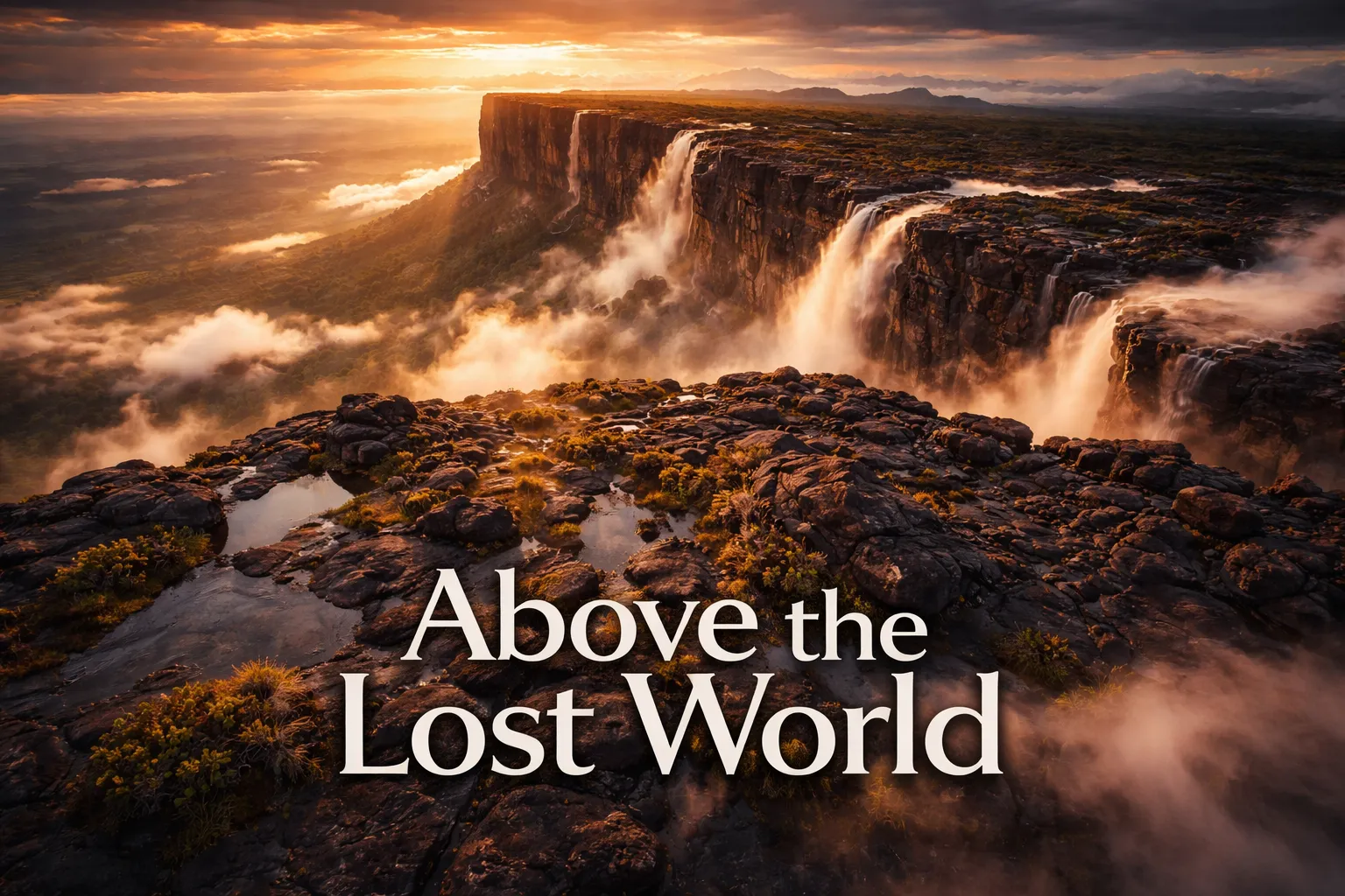
Miss that narrow morning window and you’ve wasted a four-to-six-day trek for nothing — Roraima’s summit doesn’t wait for anyone, drone pilot or otherwise. That’s the stake here, and I didn’t fully grasp it until my own aircraft cleared the treeline at the mountain’s base and the summit plateau filled my controller screen; for a second I assumed the FPV feed had glitched. Two decades of shooting from the air hadn’t prepared me for what mount roraima drone photography venezuela actually delivers: a flat-topped massif the size of a small city, boxed in by 400-meter vertical cliffs, generating its own private weather, looking far more like an orphaned planet floating over the Gran Sabana than anything belonging to this one. This is the tepui that pushed Arthur Conan Doyle to write The Lost World. Get it airborne and you’ll see exactly why.
Roraima Drone Flight Snapshot: Key Numbers Before You Launch
| GPS Coordinates (Summit Plateau) | 5.1438° N, 60.7625° W |
| Elevation | 2,810 m (9,219 ft) above sea level |
| Recommended Altitude Range | 50–180 m AGL above summit; 300–500 m AGL from base approaches |
| Best Time of Day to Fly | 05:30–08:00 AM — before daily cloud formation engulfs the summit |
| Best Season | December–April (dry season); February is peak clarity |
| Drone Regulations — Venezuela | INAC (Venezuela’s civil aviation authority) requires prior authorization for drone operation; enforcement is highly unpredictable; most commercial drone operators currently avoid Venezuelan access routes entirely |
| Drone Regulations — Brazil (Pacaraima approach) | ANAC/DECEA approval required; recreational drones under 250g may have simplified requirements; always file a SARPAS flight plan via DECEA |
| Drone Regulations — Guyana | Guyana Civil Aviation Authority (GCAA) requires a permit for drone operations; apply minimum 30 days in advance |
| Skill Level Required | Advanced — high altitude, extreme weather, GPS interference reported on summit, no rescue infrastructure |
| Difficulty Rating | ⬛⬛⬛⬛⬜ 4/5 — Expert terrain |
Everything the Aerial Perspective Shows That You Can’t See From the Trail
From the base camp, all you get is wall — a colossal, ancient, moss-blackened slab of rock. That’s the entire show. The mountain hoards its secrets from anyone standing on solid ground, almost spitefully so. Flip to the mount roraima aerial view tepui perspective and everything changes. Climb to 300 meters over the summit plateau and the full 31-square-kilometer tabletop opens up in all its strange geometry. The surface, far from flat, turns out to be a maze of black quartz formations — locals and geologists call it “Roraima tepui karst” — pocked with tannin-dark pools that read as deep amber and rust against the surrounding stone.
The waterfalls might be the real surprise. Roraima holds some of the planet’s tallest uninterrupted drops — several clear 300 meters — yet none of them register from ground level, because they scatter into mist and updraft long before touching earth. Altitude is the only vantage that reveals the entire sequence: the thin white ribbon leaving the rim, the burst into spray partway down the cliff, the hazy curtain where falling water dissolves into fog. I spent a full morning hovering at 250 meters following one nameless cascade on the Venezuelan side, and even the footage I brought home undersells how otherworldly it looked in person.
The tripoint — the exact spot where Venezuela, Brazil, and Guyana converge at the plateau’s southern edge — is another detail that only clicks once you’re airborne. The Valley of Crystals (Valle de los Cristales), a stretch of the summit scattered with quartz and rose-quartz outcrops, reads in aerial shots as a pale, faintly luminous band slicing through the dark rock. And the vegetation found nowhere else on Earth — carnivorous plants, miniature orchids, all growing on a surface that’s roughly 2 billion years old — adds a texture to the imagery that feels less like botany and more like something out of deep time.
Framing the Shot: Composition Ideas for Gran Sabana Drone Photography
Above all else, gran sabana drone photography pays off for whoever gets up earliest and waits the longest. The composition every photographer is really here for — the one that makes the entire punishing approach worthwhile — is the “island floating above the clouds” shot. You’ll need your drone somewhere between 400 and 600 meters above the summit (putting you around 3,200–3,400 meters absolute altitude) during that short morning stretch when the Gran Sabana lowlands below are still buried in low cloud. Roraima’s summit pokes up through the cloud layer, and you’ve got roughly 45 minutes before that same cloud climbs high enough to swallow the plateau.
To capture the cliff-face waterfalls, run your drone parallel to the escarpment at 50–100 meters above the plateau’s edge, camera tilted 45 degrees downward toward the rock face. Between 06:00 and 08:00, morning light striking the east-facing Venezuelan escarpment throws long raking shadows across the vertical stone, exposing geological banding that flat midday light completely hides. If you want the tabletop mountain venezuela from above shot that captures the plateau’s full scale, you’ll need real altitude — 500 meters AGL at minimum — with the drone roughly 2 kilometers back from the nearest cliff edge, shooting inward on a wide-angle equivalent.
The summit’s karst pools look their best shot nearly straight down — an 80 to 90 degree nadir angle from 80–120 meters — and preferably under overcast skies, which won’t be in short supply, since flat light kills the harsh reflections. That amber-and-black contrast in the pools doesn’t resemble anything else you’ll shoot from the air. Shoot RAW, bracket every exposure, and set aside real time in post-processing — the gap between the black stone, the glowing pools, and the white cloud drifting overhead pushes the tonal range about as far as it goes.
The Regulatory Maze: Where You’re Actually Allowed to Fly
There’s no tidy answer here, because the reality on the ground is messy. Officially, flying a drone at Roraima means securing authorization from whichever country’s airspace you’re in — Venezuela’s INAC, Brazil’s ANAC/DECEA, or Guyana’s GCAA — and none of those approval processes move fast. Venezuela’s ongoing political and infrastructure troubles make dependable INAC clearance nearly impossible for foreign visitors to secure. Nearly every serious drone photographer I know who’s shot Roraima recently has gone in exclusively through Brazil, starting from the town of Pacaraima in Roraima State and trekking in via Canaima National Park’s Brazilian entry point.
Brazil’s DECEA SARPAS system actually works — file the flight plan, keep your paperwork on you, and expect park rangers along the multi-day trek in to ask for it. The summit itself falls inside Venezuela’s Canaima National Park, a UNESCO World Heritage Site, which stacks on an extra layer of regulation. Venezuela broadly bans unauthorized drone flights inside its national parks. In practice, enforcement at a summit that requires 4 to 6 days of trekking to reach looks very different from enforcement at a roadside overlook — but flying without authorization still carries genuine legal and ethical risk. I’m not telling you to skip the rules, and none of this is legal advice. Sort your paperwork before you leave home.
The broader lost world mountain drone photography scene operates largely in a legal gray zone up here, and it’s worth naming that plainly. Shooting commercially raises the stakes considerably, and full authorization stops being optional. Flying a sub-250g drone recreationally through Brazilian airspace on the Brazilian approach eases the regulatory load somewhat, but “somewhat easier” is nowhere near “no rules apply.” Worth noting too: at 2,810 meters, the summit’s thin air noticeably saps drone performance — expect flight time and lift capacity to drop by roughly 20–30% compared to what you’d get at sea level.
Timing Your Visit: When the Sky Actually Cooperates
Roraima generates its own microclimate and sees rain on something like 300 days a year — this isn’t a destination where you book a flight date and count on decent weather showing up. The dry season, December through April, gives you the best odds at a clear morning, with February and March standing out as the statistical high point for summit visibility. Even then, cloud typically swallows the summit again by 10 or 11 in the morning. Your real working window for aerial shots is the two to three hours right after sunrise, and you won’t get it every single day. Plan on at least three or four nights at summit camp if you want a realistic shot at catching that clear morning.
Wet season, May through November, doesn’t rule out photography entirely — some of the most striking Roraima images come from storm light and brief cloud breaks — but usable flight windows get scarce and hard to predict, and the extra rainfall puts real strain on electronics. Visiting in the shoulder months, late November or late April, might land you in transitional weather with dramatic cloud but not constant downpour. Whichever season you pick, bring serious waterproofing for every single piece of gear.
The Real Reason I Went Through So Many Propellers Up There
Roraima’s weather doesn’t play fair — sudden wind shear, micro-gusts firing off the cliff face with zero warning, plus constant altitude shifts — and together they chew through propellers at a rate calm-weather flying never approaches. I found this out the hard way when a gust grabbed my drone at 350 meters and I had to gun the throttle just to keep it from drifting straight into the rock.
The upside
- The tool-free swap system saves you precious daylight in the field — and up here, with maybe two hours of usable light before the clouds close back in, that time actually matters.
- Since replacements ship in pairs, cracking one blade on a rough maneuver doesn’t end your shoot — you’ve already got a spare on hand instead of packing it in early.
- Balance quality is tight enough that vibration never creeps in, even at altitude where the air’s thinner and your margin for error shrinks.
The downside
- Replacing these repeatedly isn’t cheap, and out here there’s no shop to duck into — every extra set you left at home turns into a regret fast.
- The packaging can’t handle rough travel — mine showed up bent, and I burned an hour carefully straightening blades before I could even get the first flight in.
I almost didn’t pack a backup set for the final day of shooting, convinced I’d been careful enough to avoid another loss—then the wind picked up at sunset and I was genuinely grateful I’d overprepared. 8Pcs HS175D Propellers replacement set
Frequently Asked Questions
What drone altitude should I use to photograph Mount Roraima’s waterfalls?
To capture the cliff-face waterfalls, run your drone parallel to the escarpment at 50–100 meters above the plateau’s edge with the camera tilted 45 degrees downward toward the rock face. Between 06:00 and 08:00, morning light striking the east-facing Venezuelan escarpment throws long raking shadows across the vertical stone, exposing geological banding that flat midday light completely hides.
When is the best time to fly drones at Mount Roraima?
The best time of day to fly is 05:30–08:00 AM, before daily cloud formation engulfs the summit. The best season is December–April during the dry season, with February offering peak clarity. Plan on at least three or four nights at summit camp if you want a realistic shot at catching a clear morning.
What drone permit do I need for Mount Roraima in Brazil?
Brazil’s ANAC/DECEA approval is required. Recreational drones under 250g may have simplified requirements. You must file a SARPAS flight plan via DECEA and keep your paperwork with you, as park rangers along the multi-day trek may ask for it.
How does high altitude affect drone performance at Mount Roraima?
At 2,810 meters elevation, the summit’s thin air noticeably saps drone performance. You should expect flight time and lift capacity to drop by roughly 20–30% compared to what you’d get at sea level.
About This Article
Written by Elena Vasquez. Elena Vasquez is a full-time traveler and the founder of Witty Passport. Over fifteen years and more than 50 countries across six continents — including a stretch spent leading groups professionally through Southeast Asia and the remote highlands of South America — she's written the kind of destination guides she always wished existed: practical, specific, and built on real experience rather than recycled itineraries. More about this site.
Scope and limits. Elena is a full-time traveler, not a licensed travel agent or immigration adviser. Entry requirements, visa rules, and advisories change without notice — always confirm against the official government source for your destination and passport before booking.
Verify this against a primary source
Specifics change, and your situation may differ from the one described here. These are the authorities worth checking directly:
- U.S. Department of State — entry requirements and travel advisories
- CDC Travelers' Health — vaccination and health notices by destination
- TSA — current carry-on and screening rules