| Detail | Information |
|---|---|
| GPS Coordinates (center of salar) | 20°08′ S, 67°29′ W |
| Recommended Altitude Range | 30–150m for mirror compositions; 100–300m for geometric salt patterns and wide landscape shots |
| Best Time of Day to Fly | 30 minutes after sunrise (golden light on the salt crust) and 45 minutes before sunset; avoid midday (harsh white overexposure) |
| Best Season (Wet) | December–April for the mirror effect; peak reflection January–March |
| Best Season (Dry) | May–November for hexagonal salt patterns, starker shadows, and Milky Way shoots |
| Drone Regulations Summary | Bolivia has no dedicated national drone law as of 2025; DGAC (Dirección General de Aeronáutica Civil) technically oversees airspace. Recreational drones under 25kg are generally tolerated with no formal permit required for the open salar. Commercial operators should seek DGAC clearance. Always confirm current rules before departure. |
| Skill Level Required | Intermediate to Advanced — altitude reduces battery performance by 20–30%, featureless terrain causes GPS drift, and white surface causes severe exposure metering errors |
| Nearest Town | Uyuni (approx. 25km east of salar edge) |
What the Salar de Uyuni Aerial Mirror Effect Actually Looks Like From Above
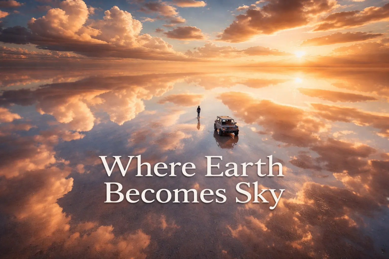
No satellite image, no listing photo, no official tourism page gets you ready for what happens the moment your drone actually clears eighty meters over the salt. Ground level already sells the wet-season mirror effect well enough — you’re standing on glass, staring at a horizon that seemingly shouldn’t exist. But send a camera skyward and the whole logic collapses. Up there the reflection is so total, so mathematically flawless, that your brain simply refuses to decide which half is sky and which half is ground. The salar de uyuni aerial mirror effect turns the world into a sphere — clouds duplicated top and bottom in matching detail, your aircraft parked, it seems, dead center of an endless blue void. A jeep sitting on the salt, or a single person standing there, reads as an astronaut cut loose from gravity, drifting in open atmosphere. Every visual cue that normally tells your eyes “this is the ground” — texture, shadow, a horizon line — has simply been erased.
Come dry season, an entirely different kind of astonishment takes over. The bolivia salt flats from above drone view exposes what visitors on foot can only guess at: the whole surface has cracked itself into hexagonal cells, each one somewhere between 1 and 2.5 meters wide, formed as the salt expands and contracts while it dries. Climb to 200 meters and those hexagons tile outward in every direction, all the way to the edge of what your eye can register. It stops looking like Earth entirely and starts resembling a wasp’s nest blown up to continental scale. Nowhere else does geology assemble this exact pattern at this size and from this vantage — and a drone is the only device capable of showing you the full geometry of it.
The Best Shots to Capture: Salar de Uyuni Drone Photography Bolivia
The Floating Figure Shot (Wet Season, 40–60m)
This is the frame responsible for a thousand travel-influencer feeds, and it still pays off every time you attempt it. Put your subject — a person, a vehicle, a local guide balanced on a bicycle — dead center in the frame. Climb to somewhere around 40–60 meters and point the lens straight down, nadir, directly overhead. With the horizon gone thanks to the reflection, your subject appears suspended in open sky. Your best light window is the ninety minutes right after sunrise, when the sky still carries warm tones that bloom beautifully once mirrored. Oddly enough, overcast days work just as well — the flat, diffused light builds a white infinity instead of a blue one, and your subject turns into a silhouette floating in pure nothing.
Isla Incahuasi Cacti at Scale (Dry Season, 150–300m)
Isla Incahuasi, sometimes labeled Isla del Pescado, is a rocky outcrop rising out of the middle of the salar, blanketed in ancient columnar cacti that can top out at 10 meters, growing at roughly a centimeter a year — meaning some specimens are estimated at 900 to 1,200 years old. Seen from above, the island reads as a single dark brushstroke on an otherwise blank white canvas. The strongest composition happens somewhere between 200–300 meters, angled 45 degrees downward, with the island tucked into the lower third of the frame and the enormous white salar filling out the rest. It’s the definitive scale shot: the island itself runs about 1.5 kilometers end to end, while the salar around it keeps going for another hundred-plus kilometers in every direction. The cacti are what save the image from turning into pure abstraction — they give it texture the eye can hold onto.
The Uyuni Train Cemetery at Dusk (Year-Round, 30–100m)
Roughly 3 kilometers outside Uyuni town sits a boneyard of steam engines and rail carriages — industrial leftovers from the 19th and early 20th century, rusting gorgeously out in the altiplano desert. Technically the railway cemetery sits outside the salar itself, but it’s a fixture on nearly every Uyuni tour and it’s remarkably photogenic from the air. At dusk, low warm light rakes sideways across the corroded metal and throws shadows the length of a football field across the flat ground. Fly at 30–80 meters and keep the angle shallow to compress perspective — line the locomotives up so they seem to march off toward the horizon. It’s the industrial-gothic counterweight to the salar’s otherworldly white, and pairing the two makes for one of the best drone landscapes south america has to offer.
Milky Way Over the Mirror (Wet Season, 10–30m)
The Salar de Uyuni counts as one of the darkest sky locations anywhere in the Southern Hemisphere — light pollution drifting out from Uyuni town is negligible, and the flat terrain gives you a full 360-degree horizon with nothing blocking it. On a moonless night during wet season, the Milky Way reflects off the thin water layer with the exact same fidelity as the daytime sky above it. Take a drone down low — 10 to 30 meters — set a long exposure, and you capture the galaxy arcing overhead with its perfect twin underneath. This is not a casual shoot: you’ll need a drone that handles low light well, manual exposure control, and either a remote trigger or an interval timer function. What comes out the other end is one of the rarest composites in aerial photography — a subject ringed by stars on every side.
Can You Fly a Drone at Salar de Uyuni? Regulations and Practical Reality
For drone photography salt flats, Bolivia’s rulebook is about as loose as it gets anywhere in South America — mostly because dedicated legislation covering small recreational and prosumer drones simply hasn’t caught up yet. As of early 2025, the DGAC (Dirección General de Aeronáutica Civil) is the body technically overseeing national airspace, but the salar carries no protected-area status that specifically bans drone flight. The terrain is so vast and open that low-altitude flying creates zero conflict with commercial air traffic. In practice, the several hundred photographers who pass through each year fly across the salt with no pushback from officials whatsoever. Still, South America’s regulatory climate can shift without much warning, so any commercial operator — shooting for a client, licensing images, producing brand content — should reach out to DGAC ahead of time and, ideally, get written clearance before landing in Bolivia. My standing advice: check current rules through official DGAC Bolivia channels and confirm again with your tour operator within 60 days of departure.
The regulations are the easy part — the real obstacles at the salar are practical ones. Sitting at 3,656 meters above sea level, the thinner air forces your drone’s motors to work harder just to produce the lift they’d generate at sea level, and most pilots see battery life drop 20–30% as a result. That listed 31-minute battery becomes something closer to 21–24 minutes once you’re actually flying at salar altitude. Bring every battery you own, keep them tucked in an interior jacket pocket to stay warm before use (cold saps capacity even further), and set your return-to-home threshold with a generous buffer. The white salt surface also wreaks havoc on exposure metering — your drone’s auto-exposure will try to tone down all that brightness and end up turning blue sky a dull gray. Switch to manual exposure, or dial in heavy positive compensation (+1.5 to +2 EV), and keep checking your histogram constantly. Lastly, that featureless white terrain gives the drone’s visual positioning system nothing to grab onto, so GPS drift becomes a real issue — fly in GPS mode and keep the aircraft within easy visual range at all times.
The UV Filter That Saved Me From Salt-Flat Lens Flare
The Salar de Uyuni functions like one enormous mirror bouncing sunlight straight into your drone’s sensor. Skip the protection and you’ll be fighting glare, blown-out reflections, and internal lens flares that turn your mirror shots into overexposed white messes.
What works
- Handles the extreme brightness bouncing off the salt crust without forcing you to stop down the aperture, so you keep the shallow depth of field that makes those reflections really pop
- Cuts down noticeably on internal reflections and ghosting that show up when you’re pointed straight into white-on-white geometry
- Light enough that it won’t slow down the Avata 2’s agility during fast, low passes over the hexagonal salt patterns
What doesn’t
- Cuts light transmission by roughly 1 to 1.5 stops, which becomes a real problem when you’re racing that 45-minutes-before-sunset window and the light is already fading fast
- Sits close enough to the lens that salt dust works its way into the threads, and once it hardens in that dry climate, unscrewing it turns into a genuine chore
I almost ditched it after my first flight—the sunset colors looked slightly duller—but then I saw the raw footage and realized the reduction in blown highlights and flare was worth the trade-off. Freewell UV Filter for the Avata 2
Frequently Asked Questions
What altitude should I fly at Salar de Uyuni for mirror effect photos?
For the best mirror compositions during wet season, fly between 40–60 meters altitude to capture subjects appearing suspended in sky. For wider landscape shots showing the full reflection effect, the recommended range is 30–150 meters, depending on your desired framing and subject placement.
When is the best time to fly drones over Salar de Uyuni?
Fly 30 minutes after sunrise for golden light on the salt crust, or 45 minutes before sunset for warm tones. Avoid midday due to harsh white overexposure. For wet-season mirror reflections, visit December–April, with peak conditions January–March. For dry-season hexagonal salt patterns, come May–November.
How much battery life should I expect at Salar de Uyuni altitude?
At the salar’s 3,656 meters elevation, expect battery life to drop 20–30% compared to sea level. A listed 31-minute battery becomes closer to 21–24 minutes in actual flying conditions. Bring every battery you own and keep them warm in an interior jacket pocket before use.
Do I need a permit to fly drones at Salar de Uyuni Bolivia?
Bolivia has no dedicated national drone law as of 2025. Recreational drones under 25kg are generally tolerated with no formal permit required for the open salar. However, commercial operators should seek DGAC clearance ahead of time, and you should confirm current rules through official DGAC Bolivia channels before departure.
About This Article

Written by Elena Vasquez. Elena Vasquez is a full-time traveler and the founder of Witty Passport. Over fifteen years and more than 50 countries across six continents — including a stretch spent leading groups professionally through Southeast Asia and the remote highlands of South America — she's written the kind of destination guides she always wished existed: practical, specific, and built on real experience rather than recycled itineraries. More about this site.
Scope and limits. Elena is a full-time traveler, not a licensed travel agent or immigration adviser. Entry requirements, visa rules, and advisories change without notice — always confirm against the official government source for your destination and passport before booking.
Verify this against a primary source
Specifics change, and your situation may differ from the one described here. These are the authorities worth checking directly:
- U.S. Department of State — entry requirements and travel advisories
- CDC Travelers' Health — vaccination and health notices by destination
- TSA — current carry-on and screening rules