
| Primary GPS Coordinates | Oia: 36.4618° N, 25.3753° E | Fira: 36.4168° N, 25.4313° E | Caldera offshore: 36.4000° N, 25.3600° E |
| Recommended Altitude Range | 80–180m for architectural detail; 180–400m for full caldera overview (subject to local airspace restrictions) |
| Best Time of Day | Golden hour (45 min before sunset) and blue hour (20 min post-sunset); early morning 06:00–08:00 for crowd-free shots |
| Best Season | April–June and September–October; avoid July–August (peak winds, tourist saturation, stricter enforcement) |
| Drone Regulations Summary | Hellenic CAA (HCAA) rules apply. EU drone regulations in force. Santorini National Airport (JTR/LGSR) creates a mandatory exclusion zone — no fly within approximately 5 km of the runway without ATC authorization. NOTAM checks required before every flight. Drone registration and EU remote pilot certificate (A1/A3 or A2 depending on drone class) required for most flights. Flying over crowds is prohibited. Always verify current NOTAMs at the Hellenic CAA portal before flying. |
| Skill Level Required | Intermediate — strong thermal winds off the caldera cliffs, proximity to populated structures, and airspace complexity make this unsuitable for first-time drone pilots |
| Permit Required | EU drone registration required; specific flight authorization may be needed in controlled zones near JTR airport |
What the Aerial View Reveals: Santorini Caldera From Above
From the ground, Santorini is beautiful but disorienting. The caldera looks like a dramatic bay. From altitude, the truth is extraordinary: you’re looking directly down into the collapsed throat of a supervolcano. The Santorini caldera from above reveals a near-perfect crescent of land — the remnant rim of a magma chamber that catastrophically collapsed around 1,600 BCE in one of the largest volcanic eruptions in recorded human history. The eruption was so powerful it’s theorized to have contributed to the collapse of the Minoan civilization. At 400 meters altitude, the entire caldera basin — roughly 12 km across — fits in a single frame, with the volcanic islands of Nea Kameni and Palea Kameni sitting in the center like geological punctuation marks. This is a perspective that makes the textbook description viscerally real.
Dropping back down to 80–120 meters over Oia reveals something entirely different: the architecture becomes abstract. The blue-domed churches, when viewed from directly above, transform into pure geometric circles set against blinding white rectangles. The narrow staircases that tourists navigate in single file appear as hairline cracks in the white surface of the cliff. Infinity pools — perhaps the most photographed design element in Santorini — are only comprehensible from above, where you can see how they’re literally bolted to the caldera face, their water edges aligning perfectly with the horizon 300 meters below them. I counted eleven distinct pools along a 400-meter stretch of cliff in Oia alone, all invisible from street level.
The volcanic geology also explains the island’s dramatic color palette in a way ground-level photography can’t. The black sand beaches of Perissa and Perivolos and the red volcanic formations at Red Beach are separated by only a few kilometers, but from altitude you can trace the geological strata that produced them — layers of ash, pumice, and lava flows stacked in the cliff faces like pages of a history book. The contrast between the white Cycladic architecture, the rust-red volcanic cliffs, and the deep Aegean blue is a composition that only the aerial view can contain in a single frame.
Best Drone Spots in Santorini Greece: The Compositions That Deliver
After extensive field time across the island, these are the specific compositions I return to — with the altitudes and angles that make them work.
1. The Oia Sunset Viewpoint — From 150 Meters
The famous Oia sunset that draws hundreds of tourists to the castle ruins every evening looks completely different from 150 meters directly above the village. From this altitude, you capture the entire village as a white river flowing down the caldera rim, with the sun dropping toward the volcanic island of Thirasia in the background. The best angle is slightly north of vertical — roughly 60 degrees nadir — which keeps the caldera water visible in the foreground while showing the village’s density. Launch from the less-congested eastern side of Oia village, away from the crowd concentration, and be aware that the thermal updrafts off the caldera cliff face intensify significantly in the hour before sunset. The Santorini aerial view Oia drone shot at golden hour is the hero image of this island, but it requires patience and precise timing.
2. The Full Caldera Crescent — Offshore at 300–400 Meters
The definitive overview shot requires launching from the caldera’s western water surface — either from a boat or from the shoreline near the port of Ammoudi Bay, which sits at water level below Oia. At 300–400 meters altitude and positioned roughly 1 km offshore into the caldera, you can capture the entire northern arm of the island in a single frame with both Oia to the north and Fira visible to the south. This is the shot that shows the volcanic island chain in context. Note: this is also the composition most affected by the airport exclusion zone, as Santorini Airport sits on the southeastern tip of the island. Always pre-flight check your airspace app to confirm your planned position clears the airport CTR boundary.
3. Red Beach and Akrotiri — Color Contrast at 80 Meters
Red Beach, near the ancient site of Akrotiri on the southwestern tip of the island, is one of the most dramatic color contrast shots in all of drone photography Greek islands coverage. At 80 meters, the rust-red volcanic cliffs against the turquoise cove create an almost artificial-looking color palette. The best shot is a low oblique angle from over the water looking back toward the cliffs, with the beach as a narrow red crescent at their base. Launch from the road above the beach access point, keep battery reserves high — this area has limited landing options — and fly in the morning when the cliff face is in direct light.
4. Fira’s Cliff Path — The Architectural Detail Shot
The path connecting Fira to Oia along the caldera rim, when viewed from 100 meters, reveals Santorini’s architectural density in its most extreme form. The whitewashed buildings stack against each other like compressed sugar cubes, and the blue domes appear at irregular intervals. This is the shot that performs best for close-crop architectural abstracts. Fly this section in early morning before 08:00 — it’s the only time the path is empty enough to avoid the crowd-flying prohibition, and the low easterly sun creates long shadow lines that define the geometry of every dome and wall.
Can You Fly a Drone in Santorini? Regulations and Practical Reality
This is the section where I’ll be direct: drone flying in Santorini requires advance preparation, and there are real restrictions that catch unprepared pilots off-guard. Greece operates under EU drone regulation framework (EU 2019/947), enforced locally by the Hellenic Civil Aviation Authority (HCAA). Here’s what that means in practice:
- Drone registration is mandatory. All drones above 250g must be registered with the HCAA before flight in Greek airspace. EU-registered drones from other member states are recognized under the EU framework.
- Remote pilot certification applies. Depending on your drone’s class and intended operations, you’ll need an A1/A3 or A2 certificate of competency under the EU Open Category framework. The DJI Mini 4 Pro and Mini 5 Pro fall under 249g and qualify for certain Open Category A1 operations, but this doesn’t exempt you from all rules.
- Santorini Airport (JTR/LGSR) creates the most significant practical constraint. The airport’s controlled traffic region creates a no-fly zone that covers a substantial portion of the island’s southeastern section, including areas around Kamari and Perissa. The runway approach path from the northeast directly limits shots of the eastern coastline. Use apps like AirMap or DJI’s GEO system with updated maps to visualize the exact boundaries before launching.
- Flying over crowds is explicitly prohibited under EU drone regulations — a rule that’s particularly significant in peak-season Santorini, where tourist density on the caldera rim path makes compliant flying genuinely difficult in summer. This is a primary reason I recommend April–June and September–October for drone photography here.
- NOTAM checks before every flight are non-negotiable. Santorini hosts occasional charter and scheduled flight surges; temporary flight restrictions appear regularly. Check the Hellenic CAA NOTAM system and your drone app before every single session.
The honest bottom line: legal, rewarding drone photography in Santorini is absolutely achievable, but it requires the same preparation discipline you’d apply to any complex airspace environment. Pilots who show up with unregistered equipment and no airspace awareness face fines and equipment confiscation. Do the paperwork in advance.
Best Season for Santorini Drone Photography: Timing Your Visit
April through June is the optimal window for aerial photography in Santorini. The light is extraordinary — clear Aegean skies with visibility that can extend to the Turkish coast on calm days — and tourist crowds are manageable enough to comply with crowd-avoidance regulations while still having the context of an inhabited, active island. Winds are generally moderate in spring, though the thermal activity off the caldera cliffs becomes pronounced by early afternoon. I fly mornings until about 10:00 and return for the golden hour session, avoiding the midday period when thermals are most aggressive.
September and October offer the second-best window. Summer crowds have thinned, the light takes on a warmer, more golden quality than spring, and the Meltemi wind — the dominant summer wind of the Aegean that can hit 6–7 Beaufort in July and August — has largely subsided. The Meltemi is the single biggest operational challenge for drone photography on Santorini; at its peak, it makes flying any sub-500g drone a genuine risk. The caldera’s cliff orientation channels and accelerates the wind, creating gusts significantly stronger than the ambient wind reading. If your weather app says 20 km/h in August, the actual wind you’ll encounter off the caldera rim may be 35–40 km/h. September conditions are dramatically more forgiving.
July and August: I don’t recommend these months for drone photography here. Wind, crowds, tourist regulation sensitivity, and heat haze all work against you simultaneously. If you’re visiting Santorini in summer for other reasons and want to shoot, pre-dawn early morning is your only viable window.
Gear Worth Packing for Santorini Aerial Photography
Choosing the right drone for Santorini is a genuine operational decision, not just a preference. Here’s what I recommend and why each piece of kit matters specifically for this location.
The DJI Mini 4 Pro Fly More Combo Plus with DJI RC 2 is my primary recommendation for most Santorini photographers, and the Fly More Combo Plus configuration is specifically important for this location. The 135-minute total flight time across three Intelligent Flight Battery Plus units means you can execute a full golden hour session — including the critical 40-minute window when Santorini’s light is at its most dramatic — without a single battery swap interruption. The drone’s sub-249g weight keeps it in the most accessible EU regulatory category, which meaningfully simplifies your compliance situation on an island where you’ll be flying near populated areas and complex airspace. The 4K camera with omnidirectional obstacle sensing handles the thermal wind gusts off the caldera face with noticeably better stability than earlier Mini models, and on an island where unplanned drift toward a cliff face of whitewashed buildings is a real scenario, that sensing capability has saved my shot more than once. At the price point of the Fly More Combo Plus, you’re getting the complete operational package for a serious photography trip without the weight and regulatory complexity of a larger drone.
If you’re a more experienced aerial photographer and want to push image quality to its maximum potential over Santorini, the DJI Mini 5 Pro Fly More Combo with DJI RC 2 is genuinely transformative for this specific location. The 1-inch CMOS sensor captures the extraordinary dynamic range of the Santorini golden hour scene — simultaneously bright white buildings, deep shadow in the caldera, and a blazing sunset sky — in a single frame without the blown highlights and crushed shadows that smaller sensors struggle with. The 225-degree gimbal rotation is a capability I found unexpectedly valuable on Santorini: being able to tilt the camera beyond vertical into an upward angle opens up compositions looking along the cliff face from below the roofline level that are simply impossible with a standard 90-degree down-tilt gimbal. The ActiveTrack 360° is particularly useful for capturing the movement of boats in the caldera or tracking a cruise ship entering the bay for dynamic video content. At under 249g, it retains the regulatory advantages of the Mini series while delivering image quality that competes with significantly larger and heavier platforms.
For travelers who want a complete, ready-to-fly package that anticipates every practical need of an international photography trip, the DJI Mini 4 Pro with RC 2, 128GB Memory Card, Landing Pad, and CPS 2-Year Warranty Bundle solves several real problems specific to Santorini in a single purchase. The 128GB memory card matters more than it sounds here: shooting 4K HDR video of the caldera at golden hour burns through storage quickly, and the last thing you want is a full card when the light is perfect over Oia. The landing pad is one of those items that feels optional until you actually need it — Santorini’s terrain means your launch points are often dusty volcanic gravel, paved surfaces with tourist foot traffic, or boat decks, and the pad creates a consistent, visible, debris-free launch zone that protects the gimbal on every takeoff and landing. The 2-year CPS warranty is genuine peace of mind for an international trip: if something goes wrong with the drone in the field, you have documented coverage rather than a difficult conversation with a manufacturer about travel damage. This bundle represents the thoughtfully equipped approach to a serious photography expedition.
How Santorini Connects to the Broader Greek Aerial Photography Experience
Santorini is the most visually concentrated aerial photography destination in Greece, but it’s part of a broader landscape of extraordinary drone opportunities across the country. If you’re building a Greece aerial photography itinerary, pair Santorini with Meteora — the monastery complex perched on vertical rock pillars in central Greece — for a study in contrasts: volcanic coastal
This post contains affiliate links. As an Amazon Associate, I earn from qualifying purchases at no extra cost to you.
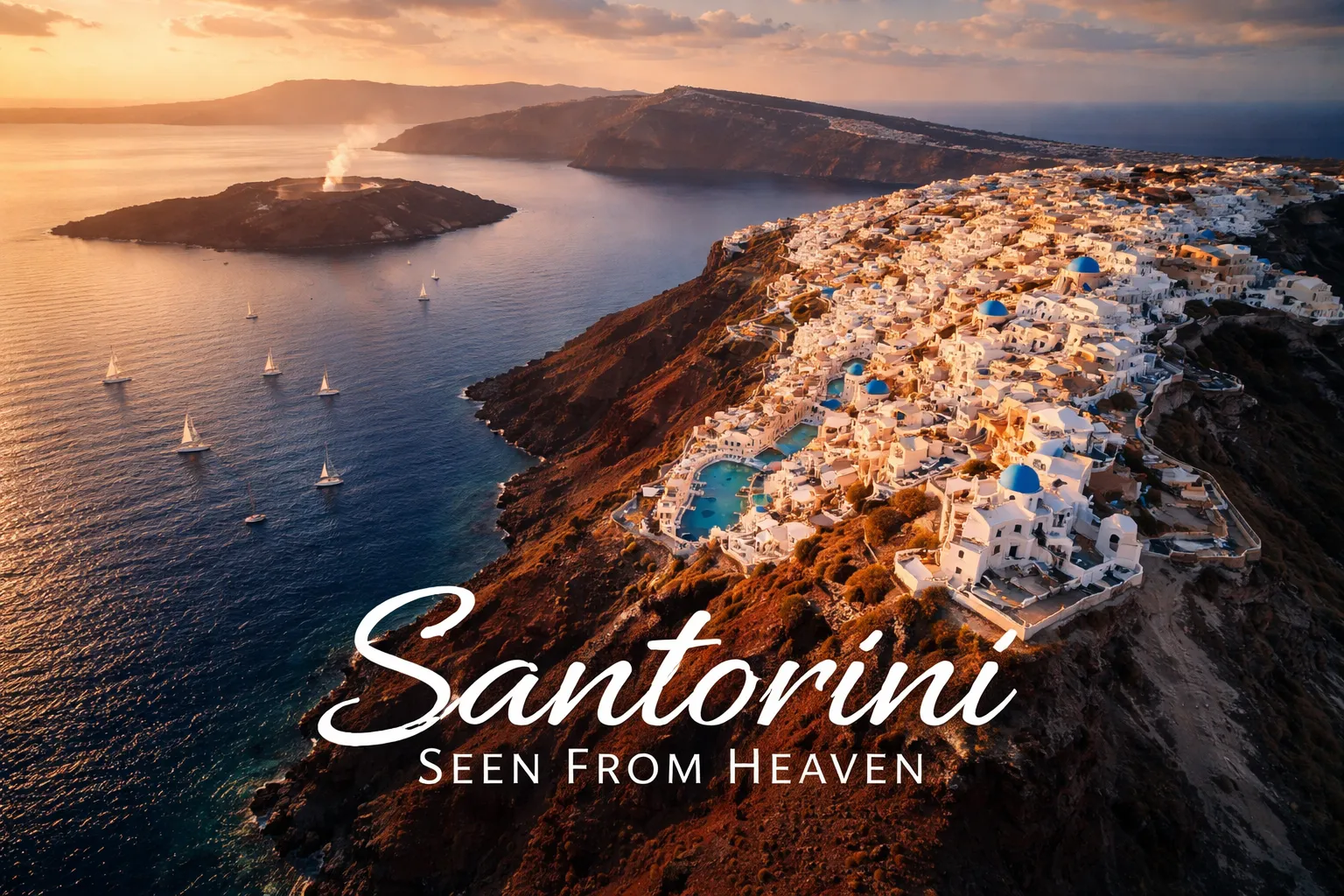
Santorini Drone Photography Greece: When the Island Finally Makes Sense
The first time I sent a drone up over Santorini, I genuinely forgot to breathe. I’d spent two days walking the clifftop paths of Oia, squeezing through whitewashed alleys, staring out at the caldera from every overlook. I thought I understood the island. I didn’t. The moment the drone cleared the rooftops and I saw the full crescent of the caldera rim stretching south toward Fira — the geometric cascade of white cubes tumbling down 300-meter volcanic cliffs, infinity pools cantilevered impossibly over the edge, and the wine-dark Aegean wrapping around it all — everything snapped into focus. Santorini drone photography Greece isn’t just a different angle on the same postcard. It’s the only perspective that makes the geology, the architecture, and the sheer audacity of this place fully legible. This guide covers everything I learned the hard way: the regulations, the compositions, the gear, and the specific moments where the light turns this volcanic island into something that doesn’t look real.
Drone Flight Brief: Santorini at a Glance
| Primary GPS Coordinates | Oia: 36.4618° N, 25.3753° E | Fira: 36.4168° N, 25.4313° E | Caldera offshore: 36.4000° N, 25.3600° E |
| Recommended Altitude Range | 80–180m for architectural detail; 180–400m for full caldera overview (subject to local airspace restrictions) |
| Best Time of Day | Golden hour (45 min before sunset) and blue hour (20 min post-sunset); early morning 06:00–08:00 for crowd-free shots |
| Best Season | April–June and September–October; avoid July–August (peak winds, tourist saturation, stricter enforcement) |
| Drone Regulations Summary | Hellenic CAA (HCAA) rules apply. EU drone regulations in force. Santorini National Airport (JTR/LGSR) creates a mandatory exclusion zone — no fly within approximately 5 km of the runway without ATC authorization. NOTAM checks required before every flight. Drone registration and EU remote pilot certificate (A1/A3 or A2 depending on drone class) required for most flights. Flying over crowds is prohibited. Always verify current NOTAMs at the Hellenic CAA portal before flying. |
| Skill Level Required | Intermediate — strong thermal winds off the caldera cliffs, proximity to populated structures, and airspace complexity make this unsuitable for first-time drone pilots |
| Permit Required | EU drone registration required; specific flight authorization may be needed in controlled zones near JTR airport |
What the Aerial View Reveals: Santorini Caldera From Above
From the ground, Santorini is beautiful but disorienting. The caldera looks like a dramatic bay. From altitude, the truth is extraordinary: you’re looking directly down into the collapsed throat of a supervolcano. The Santorini caldera from above reveals a near-perfect crescent of land — the remnant rim of a magma chamber that catastrophically collapsed around 1,600 BCE in one of the largest volcanic eruptions in recorded human history. The eruption was so powerful it’s theorized to have contributed to the collapse of the Minoan civilization. At 400 meters altitude, the entire caldera basin — roughly 12 km across — fits in a single frame, with the volcanic islands of Nea Kameni and Palea Kameni sitting in the center like geological punctuation marks. This is a perspective that makes the textbook description viscerally real.
Dropping back down to 80–120 meters over Oia reveals something entirely different: the architecture becomes abstract. The blue-domed churches, when viewed from directly above, transform into pure geometric circles set against blinding white rectangles. The narrow staircases that tourists navigate in single file appear as hairline cracks in the white surface of the cliff. Infinity pools — perhaps the most photographed design element in Santorini — are only comprehensible from above, where you can see how they’re literally bolted to the caldera face, their water edges aligning perfectly with the horizon 300 meters below them. I counted eleven distinct pools along a 400-meter stretch of cliff in Oia alone, all invisible from street level.
The volcanic geology also explains the island’s dramatic color palette in a way ground-level photography can’t. The black sand beaches of Perissa and Perivolos and the red volcanic formations at Red Beach are separated by only a few kilometers, but from altitude you can trace the geological strata that produced them — layers of ash, pumice, and lava flows stacked in the cliff faces like pages of a history book. The contrast between the white Cycladic architecture, the rust-red volcanic cliffs, and the deep Aegean blue is a composition that only the aerial view can contain in a single frame.
Best Drone Spots in Santorini Greece: The Compositions That Deliver
After extensive field time across the island, these are the specific compositions I return to — with the altitudes and angles that make them work.
1. The Oia Sunset Viewpoint — From 150 Meters
The famous Oia sunset that draws hundreds of tourists to the castle ruins every evening looks completely different from 150 meters directly above the village. From this altitude, you capture the entire village as a white river flowing down the caldera rim, with the sun dropping toward the volcanic island of Thirasia in the background. The best angle is slightly north of vertical — roughly 60 degrees nadir — which keeps the caldera water visible in the foreground while showing the village’s density. Launch from the less-congested eastern side of Oia village, away from the crowd concentration, and be aware that the thermal updrafts off the caldera cliff face intensify significantly in the hour before sunset. The Santorini aerial view Oia drone shot at golden hour is the hero image of this island, but it requires patience and precise timing.
2. The Full Caldera Crescent — Offshore at 300–400 Meters
The definitive overview shot requires launching from the caldera’s western water surface — either from a boat or from the shoreline near the port of Ammoudi Bay, which sits at water level below Oia. At 300–400 meters altitude and positioned roughly 1 km offshore into the caldera, you can capture the entire northern arm of the island in a single frame with both Oia to the north and Fira visible to the south. This is the shot that shows the volcanic island chain in context. Note: this is also the composition most affected by the airport exclusion zone, as Santorini Airport sits on the southeastern tip of the island. Always pre-flight check your airspace app to confirm your planned position clears the airport CTR boundary.
3. Red Beach and Akrotiri — Color Contrast at 80 Meters
Red Beach, near the ancient site of Akrotiri on the southwestern tip of the island, is one of the most dramatic color contrast shots in all of drone photography Greek islands coverage. At 80 meters, the rust-red volcanic cliffs against the turquoise cove create an almost artificial-looking color palette. The best shot is a low oblique angle from over the water looking back toward the cliffs, with the beach as a narrow red crescent at their base. Launch from the road above the beach access point, keep battery reserves high — this area has limited landing options — and fly in the morning when the cliff face is in direct light.
4. Fira’s Cliff Path — The Architectural Detail Shot
The path connecting Fira to Oia along the caldera rim, when viewed from 100 meters, reveals Santorini’s architectural density in its most extreme form. The whitewashed buildings stack against each other like compressed sugar cubes, and the blue domes appear at irregular intervals. This is the shot that performs best for close-crop architectural abstracts. Fly this section in early morning before 08:00 — it’s the only time the path is empty enough to avoid the crowd-flying prohibition, and the low easterly sun creates long shadow lines that define the geometry of every dome and wall.
Can You Fly a Drone in Santorini? Regulations and Practical Reality
This is the section where I’ll be direct: drone flying in Santorini requires advance preparation, and there are real restrictions that catch unprepared pilots off-guard. Greece operates under EU drone regulation framework (EU 2019/947), enforced locally by the Hellenic Civil Aviation Authority (HCAA). Here’s what that means in practice:
- Drone registration is mandatory. All drones above 250g must be registered with the HCAA before flight in Greek airspace. EU-registered drones from other member states are recognized under the EU framework.
- Remote pilot certification applies. Depending on your drone’s class and intended operations, you’ll need an A1/A3 or A2 certificate of competency under the EU Open Category framework. The DJI Mini 4 Pro and Mini 5 Pro fall under 249g and qualify for certain Open Category A1 operations, but this doesn’t exempt you from all rules.
- Santorini Airport (JTR/LGSR) creates the most significant practical constraint. The airport’s controlled traffic region creates a no-fly zone that covers a substantial portion of the island’s southeastern section, including areas around Kamari and Perissa. The runway approach path from the northeast directly limits shots of the eastern coastline. Use apps like AirMap or DJI’s GEO system with updated maps to visualize the exact boundaries before launching.
- Flying over crowds is explicitly prohibited under EU drone regulations — a rule that’s particularly significant in peak-season Santorini, where tourist density on the caldera rim path makes compliant flying genuinely difficult in summer. This is a primary reason I recommend April–June and September–October for drone photography here.
- NOTAM checks before every flight are non-negotiable. Santorini hosts occasional charter and scheduled flight surges; temporary flight restrictions appear regularly. Check the Hellenic CAA NOTAM system and your drone app before every single session.
The honest bottom line: legal, rewarding drone photography in Santorini is absolutely achievable, but it requires the same preparation discipline you’d apply to any complex airspace environment. Pilots who show up with unregistered equipment and no airspace awareness face fines and equipment confiscation. Do the paperwork in advance.
Best Season for Santorini Drone Photography: Timing Your Visit
April through June is the optimal window for aerial photography in Santorini. The light is extraordinary — clear Aegean skies with visibility that can extend to the Turkish coast on calm days — and tourist crowds are manageable enough to comply with crowd-avoidance regulations while still having the context of an inhabited, active island. Winds are generally moderate in spring, though the thermal activity off the caldera cliffs becomes pronounced by early afternoon. I fly mornings until about 10:00 and return for the golden hour session, avoiding the midday period when thermals are most aggressive.
September and October offer the second-best window. Summer crowds have thinned, the light takes on a warmer, more golden quality than spring, and the Meltemi wind — the dominant summer wind of the Aegean that can hit 6–7 Beaufort in July and August — has largely subsided. The Meltemi is the single biggest operational challenge for drone photography on Santorini; at its peak, it makes flying any sub-500g drone a genuine risk. The caldera’s cliff orientation channels and accelerates the wind, creating gusts significantly stronger than the ambient wind reading. If your weather app says 20 km/h in August, the actual wind you’ll encounter off the caldera rim may be 35–40 km/h. September conditions are dramatically more forgiving.
July and August: I don’t recommend these months for drone photography here. Wind, crowds, tourist regulation sensitivity, and heat haze all work against you simultaneously. If you’re visiting Santorini in summer for other reasons and want to shoot, pre-dawn early morning is your only viable window.
Gear Worth Packing for Santorini Aerial Photography
Choosing the right drone for Santorini is a genuine operational decision, not just a preference. Here’s what I recommend and why each piece of kit matters specifically for this location.
The DJI Mini 4 Pro Fly More Combo Plus with DJI RC 2 is my primary recommendation for most Santorini photographers, and the Fly More Combo Plus configuration is specifically important for this location. The 135-minute total flight time across three Intelligent Flight Battery Plus units means you can execute a full golden hour session — including the critical 40-minute window when Santorini’s light is at its most dramatic — without a single battery swap interruption. The drone’s sub-249g weight keeps it in the most accessible EU regulatory category, which meaningfully simplifies your compliance situation on an island where you’ll be flying near populated areas and complex airspace. The 4K camera with omnidirectional obstacle sensing handles the thermal wind gusts off the caldera face with noticeably better stability than earlier Mini models, and on an island where unplanned drift toward a cliff face of whitewashed buildings is a real scenario, that sensing capability has saved my shot more than once. At the price point of the Fly More Combo Plus, you’re getting the complete operational package for a serious photography trip without the weight and regulatory complexity of a larger drone.
If you’re a more experienced aerial photographer and want to push image quality to its maximum potential over Santorini, the DJI Mini 5 Pro Fly More Combo with DJI RC 2 is genuinely transformative for this specific location. The 1-inch CMOS sensor captures the extraordinary dynamic range of the Santorini golden hour scene — simultaneously bright white buildings, deep shadow in the caldera, and a blazing sunset sky — in a single frame without the blown highlights and crushed shadows that smaller sensors struggle with. The 225-degree gimbal rotation is a capability I found unexpectedly valuable on Santorini: being able to tilt the camera beyond vertical into an upward angle opens up compositions looking along the cliff face from below the roofline level that are simply impossible with a standard 90-degree down-tilt gimbal. The ActiveTrack 360° is particularly useful for capturing the movement of boats in the caldera or tracking a cruise ship entering the bay for dynamic video content. At under 249g, it retains the regulatory advantages of the Mini series while delivering image quality that competes with significantly larger and heavier platforms.
For travelers who want a complete, ready-to-fly package that anticipates every practical need of an international photography trip, the DJI Mini 4 Pro with RC 2, 128GB Memory Card, Landing Pad, and CPS 2-Year Warranty Bundle solves several real problems specific to Santorini in a single purchase. The 128GB memory card matters more than it sounds here: shooting 4K HDR video of the caldera at golden hour burns through storage quickly, and the last thing you want is a full card when the light is perfect over Oia. The landing pad is one of those items that feels optional until you actually need it — Santorini’s terrain means your launch points are often dusty volcanic gravel, paved surfaces with tourist foot traffic, or boat decks, and the pad creates a consistent, visible, debris-free launch zone that protects the gimbal on every takeoff and landing. The 2-year CPS warranty is genuine peace of mind for an international trip: if something goes wrong with the drone in the field, you have documented coverage rather than a difficult conversation with a manufacturer about travel damage. This bundle represents the thoughtfully equipped approach to a serious photography expedition.
How Santorini Connects to the Broader Greek Aerial Photography Experience
Santorini is the most visually concentrated aerial photography destination in Greece, but it’s part of a broader landscape of extraordinary drone opportunities across the country. If you’re building a Greece aerial photography itinerary, pair Santorini with Meteora — the monastery complex perched on vertical rock pillars in central Greece — for a study in contrasts: volcanic coastal