
This post contains affiliate links. As an Amazon Associate, I earn from qualifying purchases at no extra cost to you.
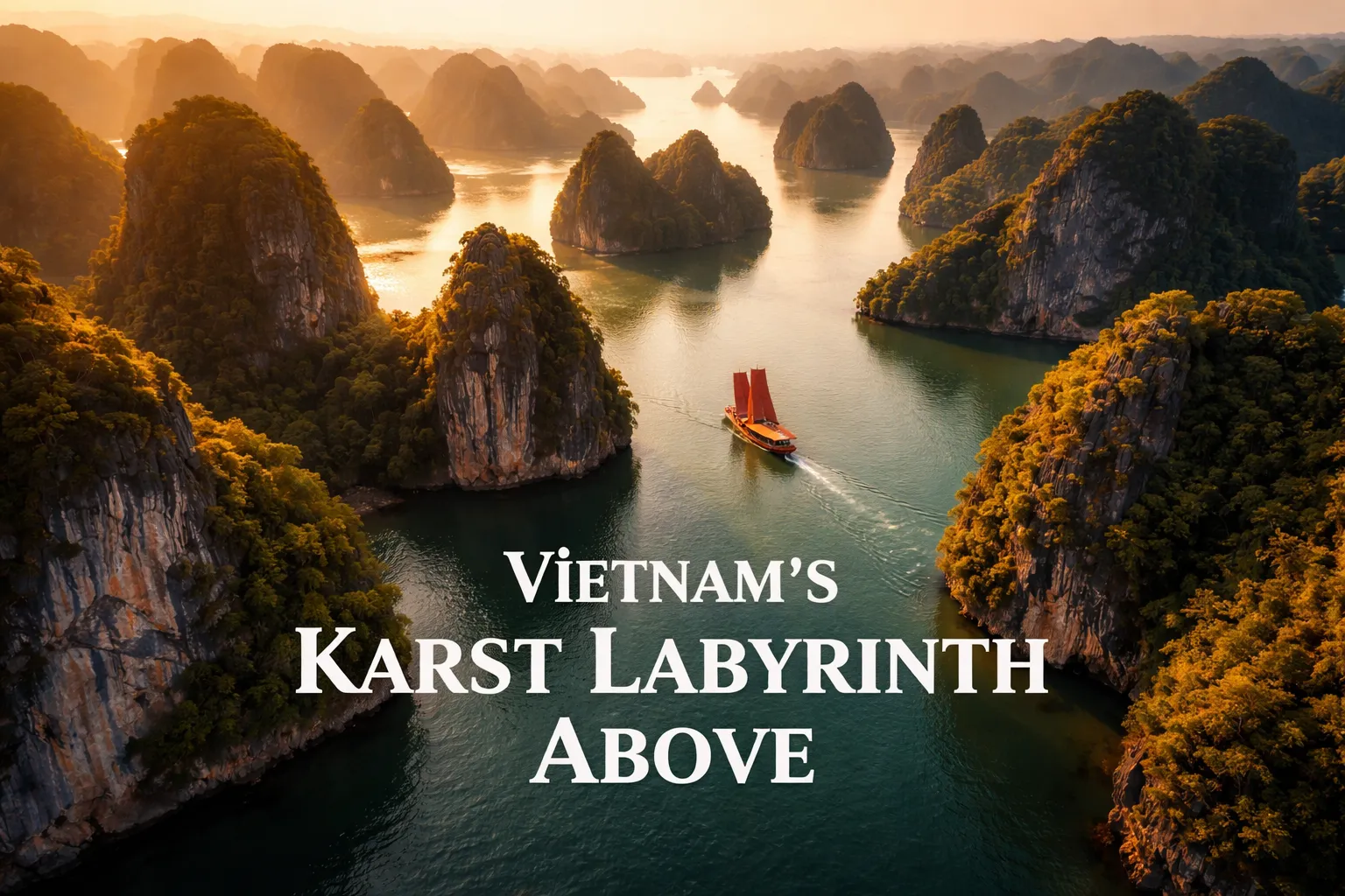
The moment my drone cleared the deck railing of our junk boat and climbed above the first limestone tower, I genuinely forgot to breathe. Ha long bay drone photography in Vietnam is one of those experiences that resets your understanding of what “landscape” means — because from 150 meters up, Ha Long Bay doesn’t look like a bay at all. It looks like a vast, flooded alien plateau where the land has been punched skyward into thousands of dark green columns, each one trailing jungle from its crown, with channels of emerald water threading between them in every direction to the horizon. No photograph I had ever seen prepared me for the sheer scale of it. That first sunrise flight — mirror-calm water, no wind, golden light grazing the karst peaks — remains the single most surreal aerial photography moment of my life.
Ha Long Bay Drone Photography Vietnam: Drone Flight Brief
| GPS Coordinates (central bay) | 20.9101° N, 107.1839° E |
| Recommended Altitude Range | 80–250 m (varies by zone; stay under 120 m near vessels and fishing villages) |
| Best Time of Day | 30 minutes before sunrise to 90 minutes after; golden hour before sunset |
| Best Season | October–April (clearest skies, calmest winds, lowest humidity haze) |
| Drone Regulations Summary | Registration and a flight permit required through Vietnam’s Civil Aviation Authority of Vietnam (CAAV); military exclusion zones exist throughout the bay; flying from cruise boats requires operator permission; enforcement is inconsistent but penalties are real — budget 2–4 weeks for permit processing |
| Skill Level Required | Intermediate to Advanced (sea winds, salt air, limited landing zones, complex airspace) |
| Difficulty Rating | 7/10 |
What the Ha Long Bay Aerial View Reveals That Ground Level Hides
Standing on a junk boat deck, Ha Long Bay is beautiful — a few dramatic karst towers, some green water, the odd fishing vessel. It’s postcard-pretty. From 200 meters above? It becomes incomprehensible. The ha long bay aerial view karst islands stretches in every direction without interruption: more than 1,600 limestone formations packed so densely that, from altitude, the water between them looks like silver veins in dark stone rather than a navigable sea. The scale is something the human eye simply cannot compute from the surface.
The most surprising revelation from the air is the hidden lagoons. Several of Ha Long Bay’s larger karst islands — and notably Cat Ba Island and Dau Be Island to the south — are hollow. Their interiors contain enclosed tidal lagoons completely invisible from any boat-level approach. Only from above can you see the oval of turquoise water sitting inside the island like a secret the limestone has been keeping for 20 million years. The geological explanation is simple: wave erosion carved sea caves through the island walls, eventually breaching them and flooding the interior. The visual result is extraordinary — dark jungle-covered walls forming a perfect bowl around a pool of improbably blue water.
The floating fishing villages — Cua Van, Vung Vieng, Ba Hang — read completely differently from altitude. At water level, they feel like a jumble of floating platforms and colorful rooftops. From 100 meters up, their geometry becomes visible: concentric rings of fish cages forming perfect circles, walkways connecting houses in grid patterns, boats arranged like spokes around a hub. These communities have an order and logic that’s entirely invisible unless you’re above them. The overhead view of a floating village against the surrounding karst is one of the most unique compositions available anywhere in drone photography.
Perhaps most strikingly, altitude reveals the color gradient of the water itself. From the surface, it all looks like one shade of green. From above, you can see the water shift from deep navy in the main channels, through aquamarine over shallow limestone shelves, to a shocking pale turquoise in the enclosed lagoons where sunlight bounces off white sand and limestone sediment. These color transitions become leading lines in their own right — the aerial photographer’s equivalent of discovering the bay has been hiding its best feature below your line of sight the entire time.
The Best Drone Spots Ha Long Bay: Compositions That Actually Work
After multiple flights across the bay in different conditions, certain compositions proved consistently powerful. Here are the shots worth planning your flight time around.
The Top-Down Channel Shot (60–80 m altitude)
Position your drone directly above one of the narrow channels between two large karst formations and shoot straight down. At this altitude, the channel walls disappear into shadow at the edges of the frame while the water below glows green — particularly powerful in the first 30 minutes after sunrise when the low angle light catches the top of the karst walls but the water channel remains in soft shadow. The best time to execute this shot is October through January when morning haze is minimal and the contrast between lit stone and shadowed water is sharpest.
The Wide Karst Establishing Shot (200–250 m altitude)
At maximum legal altitude (in open water zones away from military areas), tilt the gimbal to approximately 45 degrees and frame the scene so the nearest karst formation occupies the lower third while the field of islands recedes to the horizon. The best position for this shot is west of the main tourist zone, shooting east into the rising sun. The backlighting turns the water channels silver and silhouettes the closer karst formations, creating natural depth layers that communicate the true scale of the bay. The best drone spots ha long bay for this establishing shot are the open water sections between Bai Chay area and Dau Go Island — fewer vessels in the frame and more open sky.
Traditional Junk Boat Leading Line (100–150 m altitude)
This is the shot most people associate with Ha Long Bay photography, and for good reason — it works every time. Position the drone so a traditional red-sailed junk boat sits in the lower third of the frame, sailing through a channel between two large karst formations. The boat’s wake creates a leading line pulling the eye from foreground toward the karst maze beyond. The key detail most photographers miss: fly ahead of the boat and shoot back toward it so the boat is moving into the karst rather than away from it. This gives the composition narrative — the boat is heading somewhere, not leaving.
The Hollow Island Lagoon Overhead (straight down, 120–180 m)
Target the enclosed lagoons on the southern side of Cat Ba Island or within Dau Be Island. Fly directly over the island and position the drone above the breach point where the sea enters the lagoon — this gives you the dark sea on one side, the pale lagoon water on the other, and the dark jungle walls framing both. The color contrast in this shot is extraordinary and unlike anything else in aerial travel photography. Midday light works better than sunrise for this composition because you need the sun overhead to illuminate the lagoon floor through the shallow water.
Can You Fly a Drone at Ha Long Bay? Vietnam Drone Laws Explained
This is the section where I have to be completely honest with you, because the answer is more complicated than a simple yes or no — and getting it wrong can result in equipment confiscation, significant fines, or worse. Drone flying over ha long bay is legally possible but requires advance preparation that most visitors don’t realize they need.
Vietnam’s Civil Aviation Authority of Vietnam (CAAV) requires all foreign drone operators to register their aircraft and obtain an operating permit before flying. The registration process involves submitting your drone’s specifications, your intended flight area, and your passport details to the CAAV — and this process typically takes two to four weeks. You cannot do this on arrival in Hanoi. If you’re serious about legal drone photography in Ha Long Bay, begin this process at least a month before your trip.
Within Ha Long Bay specifically, there are additional layers of restriction. The Vietnamese military operates installations throughout the bay and on several of the islands — these areas are strictly off-limits to drone flight, and the boundaries are not always clearly marked on tourist maps. Flying within 8 km of military zones without explicit authorization is a violation of Vietnamese law. The floating fishing villages also have informal no-fly understandings with tour operators — respect these, both legally and ethically.
Practically speaking, many travelers do fly drones in Ha Long Bay without permits and without incident — enforcement is inconsistent. I am not recommending this approach. I’m telling you the reality so you can make an informed decision. If you want a legal, lower-stress alternative with genuinely stunning karst scenery, Bai Tu Long Bay — immediately adjacent to Ha Long Bay to the northeast — operates under the same national regulations but sees dramatically fewer tourists and, crucially, fewer tour boat operators who will report drone activity. The karst formations in Bai Tu Long are equally dramatic, the water is often clearer, and you’ll have compositions entirely to yourself. For a vietnam drone photography guide perspective, Bai Tu Long is honestly the better choice for photographers who want legal peace of mind and original images.
Best Time to Photograph Ha Long Bay From Above
The best season for ha long bay drone photography vietnam is unambiguously October through April — the dry season. October and November offer the ideal combination of clear skies, moderate temperatures (around 20–25°C), and the calm post-typhoon-season sea conditions that produce the mirror-flat water surface critical for reflective shots. December through February brings cooler, slightly hazier conditions but also the lowest chance of rain interrupting a flight session. March and April warm up significantly and can produce spectacular golden-hour light before the May–September wet season closes in.
Within any given day, the first 90 minutes after sunrise is the optimal flight window by a significant margin. Wind speeds in Ha Long Bay typically increase as the day heats up — by 10 AM, you’re often dealing with 15–25 km/h gusts that compromise both stability and image sharpness, and make flying near karst walls genuinely risky. The pre-sunrise departure from your junk boat, drone launched into the stillness before anyone else stirs, with mist rising off the water between the limestone pillars — that is the shot that justifies the entire trip. The second viable window is the 45 minutes before sunset, when the warm light turns the karst faces amber and the long shadows from the western towers create dramatic contrast across the bay.
Gear Worth Packing for Ha Long Bay Aerial Photography
The marine environment of Ha Long Bay is one of the most demanding for drone equipment I’ve encountered. Salt air, high humidity, the constant risk of water landings, and the need for multiple batteries per session given the limited landing zones on cruise boats — all of this shapes my gear choices here more than almost anywhere else I shoot.
The DJI Air 3 Fly More Combo with RC-N2 Remote Controller is the drone I’d recommend for most photographers visiting Ha Long Bay on a serious photography itinerary. The dual primary camera system — wide angle and medium tele — is exactly what the bay’s visual variety demands: you need the wide camera for those establishing shots showing hundreds of karst islands, and you need the tele camera to compress the distance between formations and emphasize the density of the karst field. The Fly More Combo’s three-battery configuration is non-negotiable here — you will use all three in a single sunrise session because you simply cannot afford to land and wait while the perfect mist conditions evaporate. The 48MP photo capability means you can crop aggressively and still have publishable resolution, which matters when you’re shooting from a moving boat platform where perfect framing on the first try isn’t always possible. I lost one battery to a rogue wind gust on my second morning in Ha Long and was genuinely grateful for the spares — if you’re only here for two or three days, a dead battery with no spare is a devastated shoot.
If you’re a photographer who wants the added reassurance of an integrated smart controller, the DJI Air 3 Fly More Combo with DJI RC 2 (including 1-Year DJI Care Plan) is the version I’d point you toward. The RC 2’s built-in screen eliminates the phone-connection reliability issue that becomes surprisingly stressful when you’re perched on the bow of a junk boat trying to launch before sunrise — one fewer variable to manage. But the feature that genuinely matters for Ha Long Bay specifically is the included one-year DJI Care plan: this is a marine environment, your drone will fly over open water constantly, and the statistical likelihood of a water landing over a multi-day cruise is real enough that accident coverage isn’t paranoia, it’s common sense. The 20 km video transmission range also matters more than it sounds in a bay this vast — when you’re pushing out to photograph a distant karst cluster, signal integrity is the difference between a controlled shot and a frantic return-to-home scramble. The 4K camera performance and three-battery setup mirrors the RC-N2 version, so the choice comes down to controller preference and whether the Care plan fits your risk tolerance.
For photographers who want to push into challenging light conditions — specifically the pre-dawn low light and the deep shadow interiors of the karst channels — the DJI Air 3S Fly More Combo (RC-N3) represents a meaningful step up in image quality for Ha Long Bay’s most demanding shots. The 1-inch CMOS sensor handles the extreme dynamic range between the bright sky and the deeply shadowed channel walls far better than smaller sensors — when you’re shooting a karst channel at golden hour with a bright sky overhead and dark water below, you need that sensor latitude to retain detail in both zones without HDR bracketing. The 4K/60fps HDR video capability is particularly relevant here because the slow-motion flythrough of a karst channel at 60fps, graded to bring out the water color, is cinematic in a way that standard 30fps cannot replicate. The Nightscape omnidirectional obstacle sensing also adds a genuine safety margin when flying near karst walls in the changing morning light — those walls are obstacles that will ruin your day if you misjudge the distance, and the Air 3S’s sensing coverage around all axes is meaningfully more comprehensive than previous generations.
Frequently Asked Questions About Ha Long Bay Drone Photography
Is drone photography legal in Ha Long Bay?
Drone photography in Ha Long Bay is legal only with advance registration and a flight permit from Vietnam’s Civil Aviation Authority (CAAV). Permit processing typically takes two to four weeks, so you must apply before arriving in Vietnam. Additionally, certain zones within the bay — particularly near military installations — are permanently restricted regardless of permit status. Flying without a permit is technically illegal under Vietnamese aviation law, though enforcement is inconsistent. The safest legal alternative with comparable karst scenery is adjacent Bai Tu Long Bay, which sees far fewer tourists and enforcement presence.
What is the best time of year for aerial photography in Ha Long Bay?
The best season for ha long bay drone photography is October through April — Vietnam’s dry season. October and November offer the ideal combination of clear skies, calm winds, and warm temperatures. December through February can bring light haze and cooler temperatures but remains the most reliably dry period. March and April warm significantly and produce excellent golden-hour light. The wet season from May through September brings frequent rain, strong winds, and the risk of typhoons — aerial photography during this period is difficult and often impossible for days at a stretch.
What altitude should I fly for karst island photography in Ha Long Bay?
The best altitude range depends on the shot type. For top-down channel shots emphasizing the water color and texture between karst walls, 60–80 meters is optimal. For wide establishing shots showing the full extent of the karst field, 200–250 meters (at the upper limit of legal altitude in unrestricted airspace) reveals the scale most effectively. When flying near floating fishing villages or cruise vessels, stay under 120 meters as a courtesy and safety measure. Always check local restrictions before each flight — altitude limits may be lower in specific zones near military areas.
Can I fly a drone from a cruise boat in Ha Long Bay?
Flying a drone from a cruise boat in Ha Long Bay is technically possible but requires explicit permission from both your cruise operator and the relevant Vietnamese aviation authority. Most reputable cruise operators have policies against drone launch from their vessels, both for liability reasons and because some have faced pressure from bay management authorities. If drone photography is your primary goal, research cruise operators specifically before booking — some smaller operators on three-day itineraries are more accommodating, particularly if you request permission in advance and can demonstrate your permit. Launching from designated anchorage points rather than underway is generally easier to