
This post contains affiliate links. As an Amazon Associate, I earn from qualifying purchases at no extra cost to you.
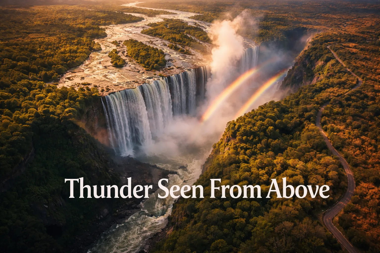
The first time I sent my drone up over Victoria Falls, I genuinely forgot to breathe. I’d seen hundreds of ground-level photographs, stood on the lip of the gorge with mist soaking through my jacket, and still nothing prepared me for what the screen showed when the drone climbed to 150 metres. The Zambezi River — wide, glassy, almost lazy — simply disappears into the earth in a single violent curtain of white. From that altitude, the geological madness of the place becomes undeniable: a kilometre and a half of water dropping 108 metres into a crack so narrow the gorge looks like a scar. If you’ve been hunting authentic victoria falls drone footage zambia zimbabwe content that goes beyond the tourist brochure shots, this is the guide I wish I’d had before I packed my bags for both sides of the border.
Victoria Falls Drone Flight Brief
| GPS Coordinates (falls centre) | 17.9244° S, 25.8567° E |
| Country Borders | Zambia (north bank) / Zimbabwe (south bank) |
| Recommended Altitude Range | 80–250 m AGL depending on spray conditions and season |
| Best Time of Day | 06:30–09:00 (golden light, low wind) or 15:30–17:30 |
| Best Season for Aerial Photography | October–December (low water, rock detail visible, manageable spray) |
| Peak Flow Season | March–May (maximum drama, maximum spray — 400 m plumes possible) |
| Zambia Drone Regulations | Permit required from Zambia Civil Aviation Authority (ZCAA); recreational flyers need registration; commercial operators need additional authorisation; national park airspace rules apply — obtain written permission from ZAWA (Zambia Wildlife Authority) |
| Zimbabwe Drone Regulations | Strictly controlled; Civil Aviation Authority of Zimbabwe (CAAZ) permit required; Victoria Falls National Park is a protected area — separate NP permit required; enforcement is active and penalties are serious |
| Skill Level Required | Advanced — mist, wind turbulence, gorge updrafts, permit complexity |
| Difficulty Rating | 🔴 Advanced / Expert |
What Victoria Falls Aerial Photography Reveals That You Cannot See From the Ground
Standing on the ground at Victoria Falls, you experience it through sensation — the roar, the mist, the rainbow arcing over the gorge. What you cannot grasp is the shape of the thing. From the air, the full 1.7-kilometre curtain reveals itself in a single frame, and the geometry is breathtaking. The Zambezi approaches from the east as an extraordinarily wide, flat river — almost 2 kilometres across in places — studded with forested islands. Then it funnels, narrows, and falls. The contrast between that serene upstream approach and the explosive downstream chaos is only legible from above.
The Batoka Gorge system downstream is the second great revelation of victoria falls aerial photography. From ground level, you can see perhaps one bend of the gorge. From 200 metres up, the zigzag pattern unfolds like a textbook diagram of geological time — each sharp right-angle turn in the gorge represents a previous waterfall position, carved over hundreds of thousands of years as the falls retreated upstream through fractures in the basalt. There are at least eight of these ancient gorges visible from the air, a timeline of planetary erosion that no ground-level photograph could ever communicate.
The permanent rain cloud — the “Smoke That Thunders” that gives Mosi-oa-Tunya its name — is also only fully appreciated from altitude. The spray plume rises 400 metres or more during peak flow season, creating its own microclimate. From above, you can see exactly where the mist ends and the African bush begins, and how the rainforest immediately bordering the falls stays perpetually green in an otherwise dry landscape. That hard edge between saturated forest and dry savanna is invisible from ground level but unmistakable from 150 metres up.
Can You Fly a Drone Over Victoria Falls? Regulations in Zambia and Zimbabwe Explained
I want to be completely direct with you here, because the internet is full of half-truths about drone laws at this location. Neither Zambia nor Zimbabwe permit casual, unpermitted drone flying at Victoria Falls. Both sides of the falls fall within protected national park boundaries — Mosi-oa-Tunya National Park in Zambia and Victoria Falls National Park in Zimbabwe — and both countries require civil aviation authority permits plus separate national park authorisation before any drone leaves the ground.
Zambia is the more permissive side. The Zambia Civil Aviation Authority (ZCAA) processes recreational and commercial drone permits, and the process, while bureaucratic, is navigable. You’ll need to register your drone, apply for airspace authorisation, and obtain written clearance from the Zambia Wildlife Authority (ZAWA) for flights within the national park. Plan for this process to take 2–4 weeks before your trip. Locals report that with proper documentation, ZAWA rangers at Mosi-oa-Tunya are professional and cooperative.
Zimbabwe requires a permit from the Civil Aviation Authority of Zimbabwe (CAAZ) and additional authorisation from Zimbabwe Parks and Wildlife Management Authority (Zimparks). Zimbabwe’s regulations are enforced more actively, and confiscation of equipment without proper paperwork is a real documented risk. Do not fly on the Zimbabwe side without permits in hand. The honest answer for most travellers? Hire a licensed local aerial operator who has existing authorisations — their footage will be legal, and it protects you from serious fines or equipment seizure.
One practical note: the drone-flying-over-victoria-falls footage you see all over YouTube exists in a grey zone. Much of it was captured before regulations tightened, or by operators who chose to fly without permits. Don’t use viral footage as evidence that it’s permitted — it isn’t.
Best Time to Photograph the Smoke That Thunders From Above
Season is everything for Zambezi river drone photography, and the tradeoffs are more dramatic here than at almost any other aerial subject on earth. The falls exist in two completely different states depending on when you visit.
October to December (Low Water Season) is my personal recommendation for drone photography. The Zambezi drops to its lowest levels, and the full basalt rock face of the falls is exposed in sections. You can see the geological strata clearly, the individual plunge pools at the base are visible, and the spray is manageable — typically 80–150 metres rather than 400 metres. Lighting conditions are stable, the sky is often clear blue, and contrast between the white water and black rock is exceptional. This is when you capture detail shots that show the structure of the falls.
March to May (Peak Flow Season) delivers raw planetary drama but makes drone photography genuinely difficult. Flow rates can exceed 500,000 cubic metres per minute, the mist column reaches 400 metres and is visible from 50 kilometres away, and the spray soaks everything including your drone’s electronics. Wide-angle shots at high altitude (200–250 m) are the only viable approach — you simply cannot fly into the spray zone at low altitude without risking your aircraft. The upside is that the rainbow arcs are enormous and persistent, visible from altitude in a way that is genuinely spectacular.
The Moonbow: During full moon nights from February through May, a lunar rainbow forms in the spray below the falls. This is one of the rarest and most photogenic night subjects in wildlife photography, and a drone equipped with a capable low-light camera at 100–150 metres altitude — positioned carefully to avoid the spray zone — can capture a frame that almost no ground-level photographer can replicate. This requires advanced night flying skills, excellent knowledge of the spray patterns, and full permits for night operations (an additional consideration in both countries).
The Best Shots to Capture: Drone Compositions at Victoria Falls
The Full Curtain Overview (200–250 m, Nadir + 30° Tilt)
Position the drone on the Zambia side, approximately 300 metres upstream from the falls lip, at 200–250 metres altitude with the camera tilted 30–45 degrees toward the falls. This is the hero shot — the full 1.7-kilometre curtain visible in a single frame with the calm Zambezi stretching upstream. Shoot in the golden hour after sunrise when the spray catches warm light and the shadows define the gorge edge. Best in October–December when the full width is visible.
The Gorge Zigzag (150–200 m, Looking Downstream)
Fly downstream along the Batoka Gorge at 150–200 metres, camera pointing 45 degrees downward toward the gorge floor. The sequential right-angle bends of the ancient gorge system create a natural leading-line composition that pulls the eye downstream through geological time. This shot is completely unique to aerial perspective — it literally does not exist from the ground. Best light is early morning when shadows define the gorge walls.
The River Approach (80–100 m, Looking Upstream)
Position downstream of the falls looking back upstream at low altitude, capturing the Zambezi islands and the falls in the background. The contrast between the forested islands in calm water and the chaos of the falls creates a compelling before-and-after composition. This works best in October–November when water levels are low enough to expose significant areas of the basalt rock islands.
The Spray Column at Altitude (250 m, Full Vertical Tilt)
During peak flow season, fly to your maximum permitted altitude and shoot directly at the spray column rising from the gorge. The mist plume has internal structure — denser at the base, wisping at the top — that reads beautifully at high altitude. The rainforest edge around the falls appears vivid green against the brown dry-season bush, and rainbow arcs appear frequently between 09:00 and 11:00 when the sun angle is optimal.
Gear Worth Packing for Victoria Falls Drone Photography
The mist environment at Victoria Falls is genuinely hostile to drone electronics. I learned this the hard way on my first visit — a poorly chosen landing spot near the gorge edge meant my drone came down in a puddle of spray accumulation that had pooled on a flat rock. A proper waterproof landing pad is not optional here; it’s the piece of gear that determines whether your drone survives day two. The FPVtosky Nighttime Reflective Drone Landing Pad has become my go-to for wet environments precisely because it’s double-sided and waterproof — you’re landing on a surface that actively repels the moisture rather than absorbing it. The weighted design is critical at Victoria Falls because the updrafts coming off the gorge create unpredictable wind gusts near the launch zone that will tumble a lightweight pad before your drone even clears the treetops. The reflective surface also matters for the moonbow night shoot scenario — when you’re flying in darkness and need to find your launch point quickly, that reflectivity is a genuine safety feature, not a marketing gimmick. Compatible with DJI Mini 4 Pro, Air 3S, Mavic 4, and most modern consumer drones, it packs flat and adds almost nothing to your camera bag weight.
If you’re working from a research or commercial photography context at the falls — shooting multiple battery cycles across a long session on the Zambia side — you need a landing pad that handles repeated use on rough terrain without staking down. The Hoodman Weighted Trifold UAV Drone Landing Pad LP21 is built for exactly this kind of sustained field deployment. The weighted design means you don’t need to find rocks to anchor the corners — a constant frustration in the mist-covered basalt around Victoria Falls where loose rocks are scarce and kneeling down to stake a pad means soaking your knees in standing spray water. The trifold mechanism collapses to roughly one-sixth of its deployed size, which matters when you’re hiking along the gorge edge carrying a pelican case, a gimbal, and two sets of batteries. On a five-session photography day when I was launching from three different positions along the Zambia bank, this pad was deployed and packed in under 90 seconds at each location — that kind of operational speed matters when your light window is 40 minutes of golden hour and permits have conditions on flight duration.
For operators working the Zimbabwe side — where open, flat launch surfaces are easier to find near the Victoria Falls National Park viewpoints — a high-visibility landing pad becomes important for a different reason: ranger and park authority visibility. When your drone operation is permitted and above-board, you want your setup to look professional and unambiguous to anyone watching. The CQT Drone Landing Pad in 55CM Yellow/Dark Gray is the most visually distinct pad I’ve used in the field — the yellow-and-gray dual-sided design is unmistakable from a distance, which communicates “permitted, professional operation” rather than “tourist who just unboxed a drone at the viewpoint.” The waterproof construction handles the spray environment reliably, and the fast-fold mechanism means setup takes seconds. I’ve used this in conditions where the spray was coming sideways in wind gusts, and it held position purely through the weighted edge design without any stakes. Universal compatibility across DJI Mavic, Mini, and Air series means it transitions with you between drone upgrades without becoming obsolete.
Frequently Asked Questions About Victoria Falls Drone Footage: Zambia and Zimbabwe
Is it legal to fly a drone at Victoria Falls?
It is legal to fly a drone at Victoria Falls, but only with the correct permits — and obtaining those permits requires advance planning. On the Zambia side, you need registration and airspace authorisation from the Zambia Civil Aviation Authority (ZCAA) plus written permission from the Zambia Wildlife Authority (ZAWA) for flights within Mosi-oa-Tunya National Park. On the Zimbabwe side, you need a permit from the Civil Aviation Authority of Zimbabwe (CAAZ) and authorisation from Zimbabwe Parks and Wildlife Management Authority (Zimparks). Flying without permits risks equipment confiscation and significant fines on both sides of the border. The safest route for most travellers is hiring a locally licensed aerial operator who already holds existing authorisations.
What is the best season for drone photography at Victoria Falls?
October to December is the best season for drone photography at Victoria Falls. Water levels are at their lowest, exposing the full basalt rock face and geological detail of the falls. Spray heights are manageable at 80–150 metres rather than the 400-metre columns seen during peak flow. Lighting conditions are stable and predictable, with clear skies and strong contrast between white water and black rock. The tradeoff is reduced dramatic scale — for maximum visual power, March to May peak flow delivers overwhelming imagery but creates serious challenges for drone electronics and safe operation.
How do you protect a drone from the mist at Victoria Falls?
Protecting a drone from Victoria Falls mist requires layered precautions. First, maintain altitude — at 200 metres and above during low-flow season, spray density drops significantly. Second, fly from the upstream side rather than attempting to position directly over the falls gorge. Third, use a waterproof landing pad to prevent moisture ingress through the landing gear contact point. Fourth, carry microfibre cloths and silica gel packets to dry and desiccate equipment between flights. Fifth, apply a moisture-repellent coating to non-intake surfaces of the drone body. During peak flow season (March–May), some pilots use DJI drones with IPX4 splash ratings for added protection, though no consumer drone is fully waterproof for sustained spray exposure.
Can you see the Victoria Falls moonbow from a drone?
Yes — capturing the Victoria Falls moonbow from a drone is one of the most compelling night aerial photography subjects in Africa. The moonbow occurs during full moon nights between February and May when the lunar light refracts through the falls spray, creating a white or faintly coloured rainbow visible to the naked eye and clearly recorded on long-exposure cameras. The optimal drone altitude is 100–150 metres, positioned safely outside the dense spray zone. This requires night flight authorisation (an additional permit condition in both Zambia and Zimbabwe), advanced night flying skills, and a drone camera capable of long-exposure or high-ISO performance. The DJI Air