
| GPS Coordinates (Main Temple) | 13.4125° N, 103.8670° E |
| Recommended Altitude Range | 80–200m (with permit); 100–150m optimal for composition |
| Best Time of Day to Fly | 5:00–6:30 AM (pre-sunrise to golden hour); thermal turbulence builds sharply after 8:00 AM |
| Best Season | November–February (dry season; low humidity, stable air, soft morning light) |
| Drone Regulations Summary | Permits required via APSARA Authority; commercial and recreational flights both need prior written approval; enforcement is active and real; fines and equipment confiscation possible without permits |
| Skill Level Required | Advanced — low-light pre-dawn launches, crowds below, permit compliance, and complex compositions demand experience |
| Nearest Airport Restriction Zone | Siem Reap International Airport (REP) — check notam and maintain required separation; Angkor Park sits within controlled airspace corridors |
What the Angkor Wat Aerial View Reveals That Ground Level Never Could
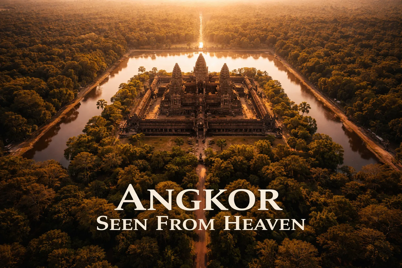
The first thing that hits you when you pull the drone up to 120 meters and look straight down at Angkor Wat is the moat. You’ve read the statistics — approximately 1.5 kilometers by 1.3 kilometers, one of the largest ancient moats on Earth — but the numbers don’t carry weight until you see it from altitude as an enormous rectangular mirror of still water framing the temple like a picture border. From the ground, you can see one bank at a time. From the air, you see the entire hydraulic logic of the site in one frame. That moat wasn’t merely decorative or defensive; it was a precision water-management structure, and from 150 meters up you can trace how it connected to the broader canal network that sustained what researchers have confirmed was the largest preindustrial city on Earth, home to an estimated 750,000 people at its 12th-century peak.
Pull back to 180 meters and the mandala geometry becomes undeniable. The three concentric rectangular galleries — each slightly elevated above the last, each aligned to cardinal directions with extraordinary precision — form a layout that Khmer architects designed to represent Mount Meru, the cosmic mountain at the center of Hindu cosmology. You simply cannot perceive this from the ground. You can read about it, you can look at architectural diagrams, but seeing the actual stone galleries resolving into their concentric-rectangle pattern from altitude is a completely different cognitive experience. The five towers snap into their quincunx arrangement — four at the corners, one at the center — and suddenly the temple makes sense as a three-dimensional cosmogram in a way that no ground-level visit ever quite achieves.
The broader Angkor Archaeological Park aerial view adds another layer entirely. The jungle hasn’t just grown around the temples — it has consumed them. From altitude, you can identify the geometric mounds of unexcavated or partially cleared temple structures hiding under forest canopy across dozens of square kilometers. The famous lidar survey published by researchers in 2016 revealed an entire urban grid beneath the jungle floor, and while your drone won’t replicate academic lidar, you will see enough from 200 meters to understand why that survey was so revelatory. The hydraulic network — the barays (massive reservoirs), the channels, the rice field grid system — is only coherent from above. Angkor’s engineering genius was a city-scale water system, and the Angkor Wat aerial view from above is the only way to see it as its architects understood it.
The Best Shots to Capture: Compositions, Altitudes, and Angles
The Sunrise Reflection Shot (Most Iconic, Most Contested)
The lotus-pond reflection shot — towers mirrored in the rectangular reflecting pools along the western causeway approach — is the single most-attempted drone shot in Southeast Asia. At ground level, photographers pack these pools before dawn with tripods touching. From the air at 60–80 meters, you get both the reflection pools and the causeway perspective simultaneously, plus the moat beyond them, plus the jungle framing. Fly this at precisely civil twilight (roughly 15 minutes before sunrise) when the sky goes that deep indigo-to-orange gradient. The towers will be silhouetted at first; as the sun clears the horizon, the stone catches gold while the moat surface stays a blue-black mirror. This is a 20-minute window and it will not repeat. Have your flight path planned, waypoints or manual heading locked, and your exposure settings pre-dialed for the low-light launch.
The Top-Down Mandala Shot
Directly overhead at 180–200 meters, pointed straight down (nadir position), with the temple centered in frame. This is the shot that took centuries to become possible. Compose so all three gallery rectangles are visible with the moat completing the outer frame. Shoot in RAW and bracket your exposures — the contrast between the reflective moat surface and the shadowed stone interiors of the galleries will challenge any single exposure. Best in the first 30 minutes of soft morning light before direct sun creates harsh shadows inside the galleries.
The Beng Mealea Jungle Canopy Shot
About 40 kilometers east of Siem Reap, Beng Mealea is a largely unrestored temple of similar scale to Angkor Wat that the jungle has genuinely overtaken. At 100 meters altitude, the stone towers and galleries push up through unbroken forest canopy in a way that reads as extraordinarily dramatic from the air. The permit and regulatory environment here is generally more accessible for drone flying over Angkor temples in the broader park context — verify current permissions with your operator, but this site has historically offered more flexibility than the main Angkor Wat complex itself. The aerial view here tells a story of entropy that is the visual inverse of Angkor Wat’s precise order.
Can You Fly a Drone at Angkor Wat? Cambodia Drone Regulations Explained Honestly
Let me be direct about this because I’ve seen too many photographers arrive with drones and vague optimism: flying without a permit at Angkor Wat will get your equipment confiscated. The APSARA Authority (Authority for the Protection and Management of Angkor and the Region of Siem Reap) controls all drone operations within the Angkor Archaeological Park, and they have rangers who enforce this actively — not occasionally. This is not a situation where you can launch quietly at dawn and hope for the best. The park is busy, there are observation points, and there are other photographers who will report unauthorized flights because they went through the permitting process and you didn’t.
For Siem Reap drone regulations at the broader national level, Cambodia’s State Secretariat of Civil Aviation (SSCA) requires drone registration and operational permits for all UAVs over 250 grams. Commercial aerial photography requires a separate commercial operation certificate. Within the Angkor Park specifically, APSARA layers additional requirements on top of SSCA’s national framework. The permitting process involves submitting a formal application to APSARA with your intended flight dates, equipment specifications, intended use (personal vs. commercial), and flight plan. Processing times vary — budget at minimum two weeks and ideally a month if you’re planning a dedicated photography trip around this. Some professional aerial photographers work through licensed Cambodian production companies or tour operators who already have standing agreements with APSARA, which can significantly simplify the logistics.
The lesser temples — particularly Beng Mealea and Koh Ker (a remote pyramid temple complex about 120 kilometers from Siem Reap) — offer more accessible options for legal aerial work within the broader Cambodia drone photography guide framework. Koh Ker’s Prasat Thom pyramid is particularly extraordinary from altitude: a seven-tiered sandstone pyramid rising 35 meters from jungle floor, looking from 100 meters like something transported from a different civilization entirely. The remoteness of Koh Ker means fewer crowds and a somewhat different administrative context than the main Angkor Park, though you still need SSCA compliance for the drone itself.
Gear Worth Packing for Angkor Aerial Photography
Cambodia’s climate in the November-to-February dry season looks benign on paper, but your drone gear faces a specific combination of challenges at Angkor: high humidity during the pre-dawn hours before temperatures rise, fine red laterite dust that permeates everything at ground level, and the kind of crowded launch environments where equipment gets bumped, jostled, and dropped on stone surfaces. Protecting your drone’s mechanical components during transport and staging is not optional here — it’s the difference between a five-day shoot and a three-day shoot followed by two days of desperate equipment repair in Siem Reap. The SDR Protection Sleeve for DJI Agriculture Agras Drone (single pack) is the piece of kit I wish I’d had on my first Angkor shoot. This form-fitting protection sleeve is designed specifically for DJI’s agricultural-grade Agras series — the T40 and T20 Pro platforms that serious commercial aerial photographers increasingly favor for their payload capacity and stability in variable conditions. At a site where you’re pre-staging your equipment in darkness on stone pavement or wet grass at 4:30 AM while managing permits, camera settings, and tourist crowd timing simultaneously, having your drone’s critical components wrapped and protected during that chaotic pre-launch window is genuinely valuable. The sleeve’s material construction provides both impact cushioning and moisture resistance, which matters when morning dew settles on every surface around the temple moat in the cool season. One bumped arm or debris-impacted motor at Angkor doesn’t just ruin a shot — it potentially ruins the entire permitted flight window you spent weeks arranging.
If you’re traveling with a crew or running multi-drone operations — which serious commercial work at Angkor sometimes requires, given that APSARA permits specify equipment in advance and having a backup platform can be the difference between a deliverable shoot and an expensive non-event — the SDR Protection Sleeve for DJI Agras (2-pack) makes obvious logistical sense. On my second Angkor shoot, I was working alongside a videographer whose primary drone developed a prop-strike issue on the first morning from an unprotected arm contacting a temple stone during a hurried repositioning. That platform was done for the trip. Having protective sleeves on both drones from the moment they leave the vehicle to the moment they’re airborne is the kind of redundancy that pays for itself the first time you’re working in a location where no drone repair shop is within 300 kilometers. The two-pack gives you consistent protection across your primary and backup platforms without the disorganized mix-and-match of sourcing protection gear from multiple suppliers with inconsistent fit and quality.
For production companies, rental operations, or photographers running workshops at Angkor — which is increasingly a category of serious aerial photography tourism — the SDR Protection Sleeve for DJI Agras (5-pack) represents the right economies of scale. When you’re responsible for protecting a fleet of platforms across a multi-day, multi-location Cambodia itinerary that might include Angkor, Beng Mealea, Koh Ker, and Phnom Penh, having five sleeves means every drone in your operation is consistently protected without improvisation. I’ve watched workshops where the instructor’s drone was immaculately protected and the rental platforms handed to students were bare — and the attrition rate on those unprotected frames across five days of field use was significant enough to affect the program’s economics in ways that a bulk purchase of protection gear would have easily prevented. The five-pack pricing reflects the reality that professional aerial operations are equipment-intensive and that protection gear is consumable infrastructure, not a one-time luxury purchase.
Timing Your Flight: Dawn Operations and the Angkor Thermal Window
The single most important tactical decision for Angkor drone photography is understanding the thermal window. Cambodia’s dry season mornings are deceptively still at 5:00 AM — the air over the moat surface is calm, temperatures are in the low-to-mid 20s Celsius, and humidity, while present, hasn’t built to its daytime oppressiveness. This is your window. By 7:30 AM, the sun has been on the stone and soil surfaces long enough to begin generating convective thermals — localized columns of rising warm air that create turbulence at low altitudes and make precise compositional control significantly harder. By 9:00 AM, the thermals over the open moat and exposed stone causeways can be strong enough to cause perceptible drone movement even at 100 meters altitude, which ruins the kind of pin-sharp long-exposure composites that make Angkor aerial shots exceptional rather than merely competent.
Plan your flight sequence so your most technically demanding shots — the nadir mandala compositions, the reflection shots requiring precise altitude hold — happen in the first 90 minutes of available light. Use the thermal-turbulence period from 8:00 AM onward for exploratory positioning, scouting, and the wider establishing shots where minor drone movement matters less. Afternoon light at Angkor can be beautiful — the western-facing main entrance facade catches warm late-afternoon sun in ways that the dawn orientation doesn’t — but afternoon thermals over the park are significantly more challenging than morning conditions. Advanced operators with stabilized platforms can work afternoon light effectively; if you’re at the intermediate level, stack your critical shooting into the dawn window and treat afternoon work as a bonus.
Frequently Asked Questions About Angkor Wat Drone Photography Cambodia
Is drone photography legal at Angkor Wat?
Drone photography at Angkor Wat is legal only with prior written authorization from the APSARA Authority, which manages the Angkor Archaeological Park. Unauthorized drone flights within the park are actively enforced and can result in equipment confiscation and fines. At the national level, Cambodia’s SSCA requires registration for all drones over 250 grams and separate permits for commercial aerial photography. Visitors should begin the APSARA permit application process at minimum two to four weeks before their intended flight dates, and working through a licensed Cambodian production company or tourism operator with existing APSARA relationships can significantly streamline approval.
What is the best time of day to fly a drone at Angkor Wat?
The optimal window for drone flight at Angkor Wat is between approximately 5:00 AM and 7:30 AM local time during the dry season (November through February). This period combines the iconic pre-sunrise and golden-hour light quality with stable, low-turbulence air conditions before convective thermals build over the stone and soil surfaces. The reflection shot using the western causeway lotus ponds is best captured in the 15–20 minutes bracketing sunrise. Thermal turbulence increases significantly after 8:00 AM and makes precise compositional control considerably harder, particularly for nadir shots and long-exposure composites.
What altitude is best for photographing Angkor Wat from a drone?
The best altitude for capturing Angkor Wat’s iconic mandala geometry — the three concentric rectangular galleries that encode Mount Meru cosmology in stone — is 150 to 200 meters, with the drone positioned in nadir (straight-down) orientation over the temple’s central tower. This altitude allows all three gallery rectangles and the outer moat to be included in a single frame with a standard wide-angle lens. For the western causeway reflection shots, 60 to 80 meters is optimal, balancing the reflection pools, causeway perspective, and moat in the same composition. Altitudes below 50 meters over the main complex are generally insufficient for revealing the geometric relationships that make aerial Angkor photography distinctive.
Are there alternative temples near Angkor where drone photography is easier to arrange?
Yes. Beng Mealea, approximately 40 kilometers east of Siem Reap, and Koh Ker, roughly 120 kilometers northeast, are both within the broader Angkor administrative region
This post contains affiliate links. As an Amazon Associate, I earn from qualifying purchases at no extra cost to you.
The moment my drone cleared the treeline west of the main causeway and I saw Angkor Wat’s five towers arranged in their lotus-bud formation against the amber pre-dawn sky, I genuinely stopped breathing. I’ve launched from cliffs in Santorini, hovered over rice terraces in Bali, and shot glaciers in Iceland — but nothing prepares you for Angkor Wat drone photography Cambodia style. From 150 meters up, what looks like a sprawling temple complex at ground level is revealed as something almost impossibly intentional: a precise geometric mandala, a cosmological diagram encoded in stone, surrounded by one of the largest moats ever constructed by human hands. Centuries of pilgrims walked its axes and climbed its towers without ever seeing what I was seeing on that 4.5-inch screen. This guide is for aerial photographers who want to do it properly — legally, creatively, and with the technical knowledge to bring home shots that genuinely show why Angkor remains one of humanity’s most extraordinary achievements.
Drone Flight Brief: Angkor Wat Aerial Photography Quick Reference
| GPS Coordinates (Main Temple) | 13.4125° N, 103.8670° E |
| Recommended Altitude Range | 80–200m (with permit); 100–150m optimal for composition |
| Best Time of Day to Fly | 5:00–6:30 AM (pre-sunrise to golden hour); thermal turbulence builds sharply after 8:00 AM |
| Best Season | November–February (dry season; low humidity, stable air, soft morning light) |
| Drone Regulations Summary | Permits required via APSARA Authority; commercial and recreational flights both need prior written approval; enforcement is active and real; fines and equipment confiscation possible without permits |
| Skill Level Required | Advanced — low-light pre-dawn launches, crowds below, permit compliance, and complex compositions demand experience |
| Nearest Airport Restriction Zone | Siem Reap International Airport (REP) — check notam and maintain required separation; Angkor Park sits within controlled airspace corridors |
What the Angkor Wat Aerial View Reveals That Ground Level Never Could
The first thing that hits you when you pull the drone up to 120 meters and look straight down at Angkor Wat is the moat. You’ve read the statistics — approximately 1.5 kilometers by 1.3 kilometers, one of the largest ancient moats on Earth — but the numbers don’t carry weight until you see it from altitude as an enormous rectangular mirror of still water framing the temple like a picture border. From the ground, you can see one bank at a time. From the air, you see the entire hydraulic logic of the site in one frame. That moat wasn’t merely decorative or defensive; it was a precision water-management structure, and from 150 meters up you can trace how it connected to the broader canal network that sustained what researchers have confirmed was the largest preindustrial city on Earth, home to an estimated 750,000 people at its 12th-century peak.
Pull back to 180 meters and the mandala geometry becomes undeniable. The three concentric rectangular galleries — each slightly elevated above the last, each aligned to cardinal directions with extraordinary precision — form a layout that Khmer architects designed to represent Mount Meru, the cosmic mountain at the center of Hindu cosmology. You simply cannot perceive this from the ground. You can read about it, you can look at architectural diagrams, but seeing the actual stone galleries resolving into their concentric-rectangle pattern from altitude is a completely different cognitive experience. The five towers snap into their quincunx arrangement — four at the corners, one at the center — and suddenly the temple makes sense as a three-dimensional cosmogram in a way that no ground-level visit ever quite achieves.
The broader Angkor Archaeological Park aerial view adds another layer entirely. The jungle hasn’t just grown around the temples — it has consumed them. From altitude, you can identify the geometric mounds of unexcavated or partially cleared temple structures hiding under forest canopy across dozens of square kilometers. The famous lidar survey published by researchers in 2016 revealed an entire urban grid beneath the jungle floor, and while your drone won’t replicate academic lidar, you will see enough from 200 meters to understand why that survey was so revelatory. The hydraulic network — the barays (massive reservoirs), the channels, the rice field grid system — is only coherent from above. Angkor’s engineering genius was a city-scale water system, and the Angkor Wat aerial view from above is the only way to see it as its architects understood it.
The Best Shots to Capture: Compositions, Altitudes, and Angles
The Sunrise Reflection Shot (Most Iconic, Most Contested)
The lotus-pond reflection shot — towers mirrored in the rectangular reflecting pools along the western causeway approach — is the single most-attempted drone shot in Southeast Asia. At ground level, photographers pack these pools before dawn with tripods touching. From the air at 60–80 meters, you get both the reflection pools and the causeway perspective simultaneously, plus the moat beyond them, plus the jungle framing. Fly this at precisely civil twilight (roughly 15 minutes before sunrise) when the sky goes that deep indigo-to-orange gradient. The towers will be silhouetted at first; as the sun clears the horizon, the stone catches gold while the moat surface stays a blue-black mirror. This is a 20-minute window and it will not repeat. Have your flight path planned, waypoints or manual heading locked, and your exposure settings pre-dialed for the low-light launch.
The Top-Down Mandala Shot
Directly overhead at 180–200 meters, pointed straight down (nadir position), with the temple centered in frame. This is the shot that took centuries to become possible. Compose so all three gallery rectangles are visible with the moat completing the outer frame. Shoot in RAW and bracket your exposures — the contrast between the reflective moat surface and the shadowed stone interiors of the galleries will challenge any single exposure. Best in the first 30 minutes of soft morning light before direct sun creates harsh shadows inside the galleries.
The Beng Mealea Jungle Canopy Shot
About 40 kilometers east of Siem Reap, Beng Mealea is a largely unrestored temple of similar scale to Angkor Wat that the jungle has genuinely overtaken. At 100 meters altitude, the stone towers and galleries push up through unbroken forest canopy in a way that reads as extraordinarily dramatic from the air. The permit and regulatory environment here is generally more accessible for drone flying over Angkor temples in the broader park context — verify current permissions with your operator, but this site has historically offered more flexibility than the main Angkor Wat complex itself. The aerial view here tells a story of entropy that is the visual inverse of Angkor Wat’s precise order.
Can You Fly a Drone at Angkor Wat? Cambodia Drone Regulations Explained Honestly
Let me be direct about this because I’ve seen too many photographers arrive with drones and vague optimism: flying without a permit at Angkor Wat will get your equipment confiscated. The APSARA Authority (Authority for the Protection and Management of Angkor and the Region of Siem Reap) controls all drone operations within the Angkor Archaeological Park, and they have rangers who enforce this actively — not occasionally. This is not a situation where you can launch quietly at dawn and hope for the best. The park is busy, there are observation points, and there are other photographers who will report unauthorized flights because they went through the permitting process and you didn’t.
For Siem Reap drone regulations at the broader national level, Cambodia’s State Secretariat of Civil Aviation (SSCA) requires drone registration and operational permits for all UAVs over 250 grams. Commercial aerial photography requires a separate commercial operation certificate. Within the Angkor Park specifically, APSARA layers additional requirements on top of SSCA’s national framework. The permitting process involves submitting a formal application to APSARA with your intended flight dates, equipment specifications, intended use (personal vs. commercial), and flight plan. Processing times vary — budget at minimum two weeks and ideally a month if you’re planning a dedicated photography trip around this. Some professional aerial photographers work through licensed Cambodian production companies or tour operators who already have standing agreements with APSARA, which can significantly simplify the logistics.
The lesser temples — particularly Beng Mealea and Koh Ker (a remote pyramid temple complex about 120 kilometers from Siem Reap) — offer more accessible options for legal aerial work within the broader Cambodia drone photography guide framework. Koh Ker’s Prasat Thom pyramid is particularly extraordinary from altitude: a seven-tiered sandstone pyramid rising 35 meters from jungle floor, looking from 100 meters like something transported from a different civilization entirely. The remoteness of Koh Ker means fewer crowds and a somewhat different administrative context than the main Angkor Park, though you still need SSCA compliance for the drone itself.
Gear Worth Packing for Angkor Aerial Photography
Cambodia’s climate in the November-to-February dry season looks benign on paper, but your drone gear faces a specific combination of challenges at Angkor: high humidity during the pre-dawn hours before temperatures rise, fine red laterite dust that permeates everything at ground level, and the kind of crowded launch environments where equipment gets bumped, jostled, and dropped on stone surfaces. Protecting your drone’s mechanical components during transport and staging is not optional here — it’s the difference between a five-day shoot and a three-day shoot followed by two days of desperate equipment repair in Siem Reap. The SDR Protection Sleeve for DJI Agriculture Agras Drone (single pack) is the piece of kit I wish I’d had on my first Angkor shoot. This form-fitting protection sleeve is designed specifically for DJI’s agricultural-grade Agras series — the T40 and T20 Pro platforms that serious commercial aerial photographers increasingly favor for their payload capacity and stability in variable conditions. At a site where you’re pre-staging your equipment in darkness on stone pavement or wet grass at 4:30 AM while managing permits, camera settings, and tourist crowd timing simultaneously, having your drone’s critical components wrapped and protected during that chaotic pre-launch window is genuinely valuable. The sleeve’s material construction provides both impact cushioning and moisture resistance, which matters when morning dew settles on every surface around the temple moat in the cool season. One bumped arm or debris-impacted motor at Angkor doesn’t just ruin a shot — it potentially ruins the entire permitted flight window you spent weeks arranging.
If you’re traveling with a crew or running multi-drone operations — which serious commercial work at Angkor sometimes requires, given that APSARA permits specify equipment in advance and having a backup platform can be the difference between a deliverable shoot and an expensive non-event — the SDR Protection Sleeve for DJI Agras (2-pack) makes obvious logistical sense. On my second Angkor shoot, I was working alongside a videographer whose primary drone developed a prop-strike issue on the first morning from an unprotected arm contacting a temple stone during a hurried repositioning. That platform was done for the trip. Having protective sleeves on both drones from the moment they leave the vehicle to the moment they’re airborne is the kind of redundancy that pays for itself the first time you’re working in a location where no drone repair shop is within 300 kilometers. The two-pack gives you consistent protection across your primary and backup platforms without the disorganized mix-and-match of sourcing protection gear from multiple suppliers with inconsistent fit and quality.
For production companies, rental operations, or photographers running workshops at Angkor — which is increasingly a category of serious aerial photography tourism — the SDR Protection Sleeve for DJI Agras (5-pack) represents the right economies of scale. When you’re responsible for protecting a fleet of platforms across a multi-day, multi-location Cambodia itinerary that might include Angkor, Beng Mealea, Koh Ker, and Phnom Penh, having five sleeves means every drone in your operation is consistently protected without improvisation. I’ve watched workshops where the instructor’s drone was immaculately protected and the rental platforms handed to students were bare — and the attrition rate on those unprotected frames across five days of field use was significant enough to affect the program’s economics in ways that a bulk purchase of protection gear would have easily prevented. The five-pack pricing reflects the reality that professional aerial operations are equipment-intensive and that protection gear is consumable infrastructure, not a one-time luxury purchase.
Timing Your Flight: Dawn Operations and the Angkor Thermal Window
The single most important tactical decision for Angkor drone photography is understanding the thermal window. Cambodia’s dry season mornings are deceptively still at 5:00 AM — the air over the moat surface is calm, temperatures are in the low-to-mid 20s Celsius, and humidity, while present, hasn’t built to its daytime oppressiveness. This is your window. By 7:30 AM, the sun has been on the stone and soil surfaces long enough to begin generating convective thermals — localized columns of rising warm air that create turbulence at low altitudes and make precise compositional control significantly harder. By 9:00 AM, the thermals over the open moat and exposed stone causeways can be strong enough to cause perceptible drone movement even at 100 meters altitude, which ruins the kind of pin-sharp long-exposure composites that make Angkor aerial shots exceptional rather than merely competent.
Plan your flight sequence so your most technically demanding shots — the nadir mandala compositions, the reflection shots requiring precise altitude hold — happen in the first 90 minutes of available light. Use the thermal-turbulence period from 8:00 AM onward for exploratory positioning, scouting, and the wider establishing shots where minor drone movement matters less. Afternoon light at Angkor can be beautiful — the western-facing main entrance facade catches warm late-afternoon sun in ways that the dawn orientation doesn’t — but afternoon thermals over the park are significantly more challenging than morning conditions. Advanced operators with stabilized platforms can work afternoon light effectively; if you’re at the intermediate level, stack your critical shooting into the dawn window and treat afternoon work as a bonus.
Frequently Asked Questions About Angkor Wat Drone Photography Cambodia
Is drone photography legal at Angkor Wat?
Drone photography at Angkor Wat is legal only with prior written authorization from the APSARA Authority, which manages the Angkor Archaeological Park. Unauthorized drone flights within the park are actively enforced and can result in equipment confiscation and fines. At the national level, Cambodia’s SSCA requires registration for all drones over 250 grams and separate permits for commercial aerial photography. Visitors should begin the APSARA permit application process at minimum two to four weeks before their intended flight dates, and working through a licensed Cambodian production company or tourism operator with existing APSARA relationships can significantly streamline approval.
What is the best time of day to fly a drone at Angkor Wat?
The optimal window for drone flight at Angkor Wat is between approximately 5:00 AM and 7:30 AM local time during the dry season (November through February). This period combines the iconic pre-sunrise and golden-hour light quality with stable, low-turbulence air conditions before convective thermals build over the stone and soil surfaces. The reflection shot using the western causeway lotus ponds is best captured in the 15–20 minutes bracketing sunrise. Thermal turbulence increases significantly after 8:00 AM and makes precise compositional control considerably harder, particularly for nadir shots and long-exposure composites.
What altitude is best for photographing Angkor Wat from a drone?
The best altitude for capturing Angkor Wat’s iconic mandala geometry — the three concentric rectangular galleries that encode Mount Meru cosmology in stone — is 150 to 200 meters, with the drone positioned in nadir (straight-down) orientation over the temple’s central tower. This altitude allows all three gallery rectangles and the outer moat to be included in a single frame with a standard wide-angle lens. For the western causeway reflection shots, 60 to 80 meters is optimal, balancing the reflection pools, causeway perspective, and moat in the same composition. Altitudes below 50 meters over the main complex are generally insufficient for revealing the geometric relationships that make aerial Angkor photography distinctive.
Are there alternative temples near Angkor where drone photography is easier to arrange?
Yes. Beng Mealea, approximately 40 kilometers east of Siem Reap, and Koh Ker, roughly 120 kilometers northeast, are both within the broader Angkor administrative region