
The first time I stood at the South Rim and looked down, I thought I understood the Grand Canyon. I didn’t. It wasn’t until I viewed helicopter footage shot from 600 meters above the Colorado River that the true scale of this place finally broke through — the canyon doesn’t just go down, it goes everywhere, a labyrinth of side canyons, buttes, and amphitheaters stretching 446 kilometers from east to west. That’s what makes grand canyon drone photography arizona one of the most searched and most legally complicated aerial subjects on the planet. The images you imagine — drone hovering over that impossible void, camera tilting slowly down toward the green thread of the Colorado River — are extraordinary. But the reality of flying here requires serious legal homework before you even unpack your bag. This guide covers both the dream and the reality, including where you can legally capture aerial images that rival anything you’ve seen online.
Grand Canyon Drone Flight Brief
| Primary Location | Grand Canyon National Park, Arizona, USA |
| Park GPS Coordinates (South Rim) | 36.0544° N, 112.1401° W |
| Horseshoe Bend GPS (Legal Fly Zone) | 36.8791° N, 111.5100° W |
| Grand Canyon West / Skywalk GPS | 35.9912° N, 113.8132° W |
| Recommended Altitude Range | 120–300m AGL at legal alternative sites (see regulations below) |
| Best Time of Day | Golden hour (30 min after sunrise, 60 min before sunset) |
| Best Season | October–November (low crowds, warm light, chance of cloud inversions) |
| Drone Regulations Summary | ⛔ BANNED inside Grand Canyon National Park (NPS Policy). Legal alternatives exist on Navajo Nation land, Hualapai Reservation, and adjacent BLM land — with proper permissions. |
| Skill Level Required | Intermediate to Advanced (wind, thermals, high elevation, complex airspace) |
| Nearest FAA LAANC Coverage | Check FAA DroneZone / Aloft app before every flight |
Can You Fly a Drone at the Grand Canyon? Understanding Drone Regulations in a National Park
Let me be completely direct about this: flying a drone over Grand Canyon National Park is illegal. The National Park Service banned drone operations across all 423 US national park units in 2014 under a policy memorandum, later codified in site-specific regulations. At Grand Canyon specifically, the prohibition covers launching, landing, or operating unmanned aircraft anywhere within park boundaries. The fine can reach $5,000, and rangers actively enforce this rule — I’ve personally witnessed confiscations at the South Rim. The temptation is understandable; the views from park overlooks are breathtaking, and you can see exactly what your drone could capture. But the legal and ethical consequences aren’t worth it. The park hosts over 6 million visitors annually, manages critical California condor habitat, and maintains strict noise policies — drones genuinely disrupt all three.
The good news — and there’s substantial good news — is that grand canyon drone regulations national park boundaries don’t extend to every dramatic viewpoint in the region. The legal landscape around the Grand Canyon is genuinely one of the most interesting in the American Southwest, because multiple sovereign jurisdictions border the park, each with different rules. This means that with proper research and permission, you can capture legal aerial footage of canyon landscapes that is visually indistinguishable from footage taken inside the park itself.
Best Grand Canyon Drone Alternatives: Where to Legally Fly
These are the locations I recommend — and have used — for legal aerial photography in and around the Grand Canyon region. Each requires different permissions and preparation.
Horseshoe Bend (Glen Canyon National Recreation Area / BLM Land)
Horseshoe Bend near Page, Arizona, is arguably the single best legal aerial photography location in the entire Grand Canyon region. The Colorado River performs a 270-degree meander here, cutting 300 meters below the sandstone rim, and from a drone altitude of 150–200 meters directly overhead, the composition is absolutely perfect — a horseshoe of deep green water wrapped in red-orange rock. The overlook area sits on a mix of BLM land and Glen Canyon NRA land; as of my most recent visit, drone flying from the BLM-administered section near the main overlook trailhead has been permissible, though the NRA portions follow the same NPS ban. Always verify current status with the Page BLM field office before flying. Wind here can shift dramatically, especially afternoon thermals rising off the canyon walls, so fly in the first two hours after sunrise.
Grand Canyon West / Hualapai Reservation
Grand Canyon West is operated by the Hualapai Tribe and sits entirely outside NPS jurisdiction. This is one of the best grand canyon drone alternatives for serious aerial photographers because the Hualapai have their own commercial permitting process for drone and aerial work. The Skywalk area and Eagle Point offer rim views that look directly into a section of the western canyon with the Colorado River visible below. Commercial drone permits require advance application and fees — contact the Hualapai Tourism Authority directly. Personal recreational drone flying without a commercial permit is not automatically permitted, so don’t assume. The visual reward for doing this correctly is significant: you can legally capture the canyon’s western reaches from angles the general public never sees.
Navajo Nation Overlooks (East Rim / Desert View Area Vicinity)
The Navajo Nation controls land along portions of the canyon’s eastern corridor. Some overlooks accessible from Highway 89 and the Navajo Route 20 corridor sit on tribal land outside NPS boundaries. Drone use on Navajo Nation land requires explicit tribal permission — this is sovereign territory with its own legal framework. Contact the Navajo Nation’s tourism office in Window Rock for current permits. When permission is granted, the eastern canyon views from Navajo land show the canyon’s narrower, more sharply defined eastern character, with the Echo Cliffs and Painted Desert visible on the horizon in wide shots.
Marble Canyon and Vermilion Cliffs (BLM Land)
North of the park boundary, Marble Canyon and the Vermilion Cliffs National Monument area includes significant BLM-administered land where drone flying is generally permitted following FAA regulations. The Vermilion Cliffs produce some of the most visually arresting aerial geology in the Southwest — layered sandstone in crimson and orange, carved by centuries of wind erosion. A grand canyon aerial view from above is not exclusively found inside the park’s boundaries; Marble Canyon’s walls tell the same geological story in striking visual detail.
Helicopter Aerial Photography Tours
For photographers who want footage actually over the Grand Canyon — legally — helicopter tours operating from Grand Canyon Airport (GCN) and Las Vegas carry passengers over the canyon with open-door options available through some operators. Maverick Helicopters and Papillon Grand Canyon Helicopters both offer photography-specific configurations. From 600–900 meters above the canyon floor, you see the full complexity of the drainage system, the meandering Colorado appearing as a thread of malachite green against the canyon’s terra-cotta geology. You cannot deploy your own drone from a helicopter, but shooting with a mirrorless camera or GoPro through an open door produces legitimately stunning results.
What the Grand Canyon Aerial View From Above Actually Reveals
The grand canyon aerial view from above reveals something that no rim-level photograph can communicate: the canyon is not a single gorge. It is an interlocking system of tributary canyons — hundreds of them — branching off the main corridor like the root system of an enormous tree. From the rim, you see one dramatic wall. From 300 meters above, you understand that the canyon has depth in every direction simultaneously.
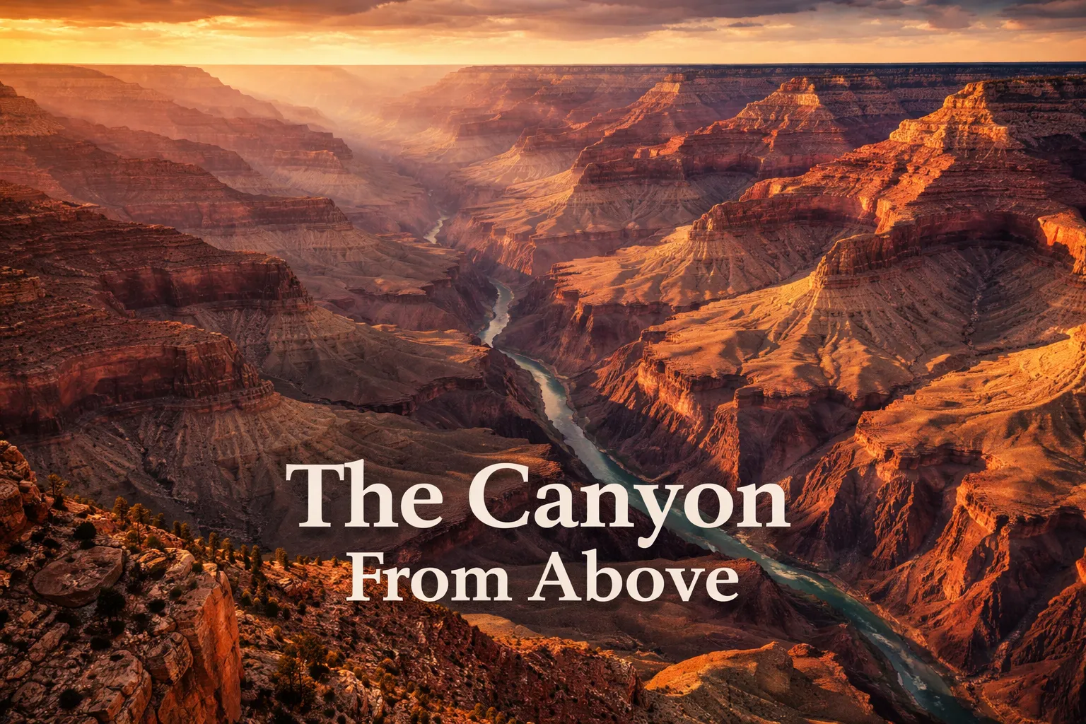
The color banding is the geological revelation that stops first-time aerial viewers cold. From altitude, the Grand Canyon displays approximately 40 distinct rock layers, each representing a different geological era. The dark Vishnu Schist at the canyon bottom is nearly 2 billion years old — some of the oldest exposed rock on Earth’s surface. Above it, the Tapeats Sandstone appears as a brown ledge. Then the Bright Angel Shale in greenish-grey. The Redwall Limestone in burgundy (actually stained red by iron oxide washing down from above — it’s naturally grey). The Supai Group in deep red. The Hermit Formation in brick red. The Coconino Sandstone in cream-white. The Toroweap Formation and finally the Kaibab Limestone in pale grey at the rim. From a drone altitude of 200 meters, you read all of these simultaneously in a single frame — a striped monument to 2 billion years of Earth history.
The Colorado River at the canyon floor appears shockingly small from altitude — a green ribbon perhaps 90 meters wide in most sections, dwarfed by the 1,800-meter walls above it. The green color comes from algae and the glacial silt that gives the water its characteristic hue. In aerial footage, that color contrast — green river against red rock — is one of the most immediately recognizable visual signatures of this landscape.
Cloud inversions, which occur primarily in winter months (December–February), fill the canyon with a white cloud sea that sits below the rim. From above, the canyon appears to be filled with fog while the rim stands in clear sunlight — an effect so visually otherworldly that footage of it routinely goes viral. The best chance of catching one is arriving at the South Rim in the early morning hours following a cold front.
Best Shots to Capture: Specific Aerial Compositions and Techniques
The Horseshoe Bend Straight-Down
Position your drone at exactly 180 meters directly above the center of the meander. Shoot straight down (nadir shot) to capture the complete horseshoe with river filling the frame. Best at golden hour when the canyon walls glow orange and the river reflects the sky. The optimal focal length equivalent is 24mm or wider.
The Canyon Wall Strata Shot
At legal rim-adjacent locations, position the drone at mid-canyon wall height and shoot parallel to the cliff face at a slight upward angle. This reveals the color banding most dramatically. Golden hour from the east (morning) illuminates the South Rim walls; golden hour from the west (evening) illuminates the North Rim face. The optimal altitude for this shot varies by location but generally 100–200 meters AGL.
The River Reveal Pull-Back
At Horseshoe Bend or Marble Canyon legal sites: start at low altitude (30–40 meters) framing the river tightly, then execute a slow reverse pull-back while ascending to 200 meters. The video shot reveals the full canyon context in a cinematic move that never fails to impress. This requires stable wind conditions — execute it only in winds below 15 km/h.
The Cloud Inversion Overflight
When a temperature inversion fills the canyon with cloud, fly (at legal sites) just above the cloud surface shooting back toward the rim. The effect — a white cloud ocean with the canyon walls rising above it — is one of the most surreal aerial images possible in North America. This requires winter timing, a following cold front, and considerable luck. December and January are peak inversion months.
Gear Worth Packing for Grand Canyon Aerial Photography
The DJI Mavic 3 Pro with RC is the drone I’d bring first to any Grand Canyon region shoot, and for a specific reason: its Hasselblad-tuned 4/3 CMOS sensor handles the extreme dynamic range of canyon light better than any consumer drone I’ve tested. At Horseshoe Bend, you’re simultaneously exposing for the bright sandstone rim and the deep shadow of the canyon walls — a difference of 5+ stops of light that will blow out or crush inferior sensors. The Mavic 3 Pro’s 43-minute flight time also matters practically here, because legal flying sites often require a significant hike from the parking area, and you want maximum air time once you arrive. The 15km HD transmission range means you can push the drone out over the canyon without signal anxiety, and the FAA Remote ID compliance keeps you legal at BLM and tribal permit sites. I’ve shot in 35 km/h gusts at Vermilion Cliffs with this drone and the footage remained stable enough for professional use.
If you’re investing at the top of the market, the DJI Mavic 4 Pro Fly More Combo with DJI RC 2 represents a meaningful leap for canyon photography specifically because of its 100MP 4/3 CMOS Hasselblad camera — a resolution that lets you shoot wide and crop aggressively to isolate specific geological features or the river far below. The 30km video transmission range and 51-minute maximum flight time are the practical specs that matter most in a location where you might be flying from a ridgeline with no convenient landing option nearby. The Fly More Combo’s inclusion of a charging hub is genuinely useful in the field: canyon region shoots often involve long drives between locations, and being able to charge three batteries simultaneously from your vehicle during transit means you arrive at each legal flying site with full power. The extended flight time also makes a genuine difference when waiting for the perfect cloud formation or light angle — you have patience to hover and wait rather than rushing your shots.
For photographers planning multiple days of shooting across different canyon-region locations, the DJI Mavic 3 Pro Fly More Combo with DJI RC solves the most common field problem I’ve encountered in remote Arizona locations: battery depletion at the wrong moment. This combo includes three intelligent flight batteries and a charging hub — critical when you’re positioned at Horseshoe Bend for a two-hour golden hour session and want to fly continuously across the window. The triple-camera system (equivalent to 24mm, 70mm, and 166mm focal lengths) is particularly valuable for canyon photography because you can capture the wide establishing shot and the tight telephoto detail shot without changing your drone’s position — useful when you’ve spent 40 minutes hiking to a perfect legal vantage point and don’t want to compromise your position. The 15km HD transmission range provides genuine confidence when sending the drone over canyon terrain where line-of-sight is complicated by topography.
This post contains affiliate links. As an Amazon Associate, I earn from qualifying purchases at no extra cost to you.
Practical Planning: Best Time to Photograph the Grand Canyon From Above
The best season for Grand Canyon aerial photography is October through November for a combination of reasons: summer crowds have thinned, the light sits lower and warmer in the sky for longer windows each day, and afternoon thunderstorm activity (a genuine drone safety hazard in July–August) has ended. October temperatures at the South Rim average a comfortable 15–20°C, making all-day shooting sessions physically manageable.
December through February offers the unique opportunity for cloud inversion photography but introduces cold and the possibility of rim road closures due to snow. Spring (March–April) brings wildflowers to the rim and softer light but also increased wind — particularly challenging for drone stability over canyon terrain.
Wind is the dominant weather concern for drone flying over grand canyon region sites. The canyon functions as a wind tunnel, accelerating air currents between its walls. At rim level, winds that seem manageable (20 km/h) can translate to 35–45 km/h gusts at mid-canyon altitude. Always check wind forecasts using Windy.com or UAV Forecast specifically for the altitude band you’ll be flying, not just surface conditions. My personal rule: if surface winds exceed 20 km/h at the legal fly site, I wait or reschedule.
High desert altitude also affects drone performance. The South Rim sits at approximately 2,100 meters elevation, while Horseshoe Bend is lower at around 1,200 meters. At South Rim elevation, drone rotors work harder in thinner air, reducing effective flight time by 10–15% compared to sea-level specs. Factor this into your battery