Moraine Lake Drone Photography: Canada’s Turquoise Crown
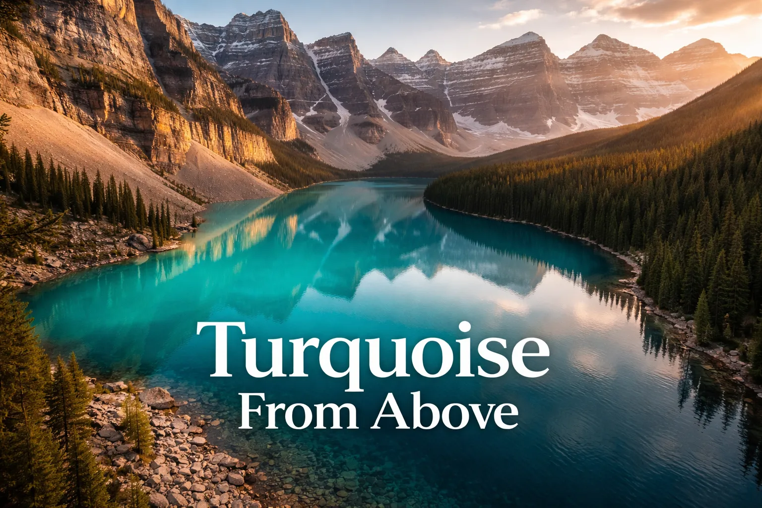
I led a group of eleven photographers to that rockpile overlook one August morning, and every single one of them walked away happy with what they’d shot. It wasn’t until months later, scrolling through footage a helicopter pilot friend sent me from a charter flight, that I realized how much we’d actually missed — the turquoise spilling out below like something mixed in a lab, too saturated to look real and yet completely unedited. That’s the pull behind moraine lake drone photography canada, now one of the most searched aerial photography topics on the continent. Ground level gives you a pretty picture. Altitude gives you a full-blown geology lesson painted in color. Here’s what you’re actually working with before you pack a single piece of gear: what the view from up there shows you, the regulatory reality nobody sugarcoats enough, and the legal paths to getting the shot anyway.
Flight Brief: Moraine Lake, Banff National Park
| GPS Coordinates | 51.3217° N, 116.1860° W |
| Elevation | 1,884 m (6,183 ft) above sea level |
| Recommended Altitude Range | 150–350 m AGL for full Valley of Ten Peaks context; 60–100 m AGL for close color/texture detail |
| Best Time of Day | 6:00–8:30 AM (golden hour light from the east, mirror-calm water before afternoon winds) |
| Best Season | Late June through mid-September; peak rock flour concentration July–August produces the most saturated turquoise |
| Drone Regulations | ⛔ DRONES ARE BANNED inside Banff National Park without a Parks Canada filming permit. Recreational drone use is prohibited in all Canadian National Parks under the Canada National Parks Act. Commercial operators must apply for a Filming Permit through Parks Canada — approvals are rare and heavily restricted near sensitive wildlife areas. |
| Legal Alternatives | Helicopter charters from Banff/Canmore; Spray Lakes Provincial Recreation Area (outside park boundary); Lake Louise corridor from approved zones; Mt. Norquay area research |
| Skill Level Required | Advanced — high altitude, unpredictable mountain thermals, limited GPS interference recovery, cold temperature battery drain |
| Difficulty Rating | ⭐⭐⭐⭐⭐ (Expert conditions even for legal alternatives) |
What Altitude Shows You That the Shoreline Never Will
From the rockpile, you get Moraine Lake framed by a wall of boulders in front and ten peaks stacked behind. It’s a stunning composition. It’s also maybe a fifth of the actual story. Get up in the air — even 250 metres up in a helicopter — and the lake stops being a pretty backdrop and starts reading like a diagram you can actually decode. The moraine itself, that massive pile of rock and sediment dumped by glaciers over millennia, suddenly makes sense as a natural dam sealing off the lower end of the valley. From below, it’s just the hill you huffed up for the photo. From above, you finally get why the lake is sitting there at all.
The color shift is where altitude really earns its keep. Glacial rock flour — that ultra-fine sediment pulverized by moving ice and suspended throughout the meltwater — bends light differently depending on how concentrated it is and how deep the water runs beneath it. From up high you can watch this play out in real time: the shallows near the moraine edge sit at a pale, minty aquamarine, and as you move toward the middle, the color deepens through bright cyan into a heavy sapphire where the lakebed drops away. No shot taken from the shore captures that whole spectrum at once. It’s the difference between admiring a gem and actually watching the process that formed it.
The valley of ten peaks from above looks like an entirely different place once you’re airborne. What reads as one dramatic wall of mountains from the shoreline turns out, from up top, to be a full three-dimensional cirque — a horseshoe of summits with their own glacial hollows, snowfields sitting at staggered elevations, and pale avalanche scars streaking down the darker rock. The lake occupies the center of this natural amphitheater, and it’s only from altitude that you register just how enclosed it is — like a gem set deliberately into a ring of stone. This is exactly the shot that keeps the canadian rockies drone photography crowd coming back to this valley.
Is Flying a Drone at Moraine Lake Actually Legal? Here’s the Real Answer
I won’t dance around this: recreational drone flights are off-limits at Moraine Lake and across the entirety of Banff National Park. It’s not a fuzzy local guideline you can talk your way around — it’s federal law under the Canada National Parks Act, enforced directly by Parks Canada wardens. Get caught and you’re looking at on-the-spot fines starting at $250, climbing into the thousands for repeat offenders or serious violations. And it’s not only about the legal exposure — this is real habitat. Golden eagles, grizzly bears, and peregrine falcons all nest along the Valley of Ten Peaks corridor, and there’s documented evidence that low-altitude drone activity disrupts their nesting behavior.
Commercial shooters — working videographers and photographers on paid assignments — do have a path: applying for a Filming Permit through Parks Canada’s Visitor Experience team. Each application is reviewed individually, requires proof of liability insurance (usually a $2 million CAD minimum), and a detailed shoot plan, and permits are rarely handed out in ecologically sensitive zones or during active wildlife seasons. Expect the process to run several weeks, and know going in that approvals specifically near Moraine Lake are rare to the point of exceptional. If you’re shooting commercially, start your application at least 90 days ahead of your target date through the official Parks Canada website.
Here’s the encouraging part: you can absolutely capture this landscape from the air legally, and in a few respects, the workarounds beat the original plan. Helicopter charters flying out of Canmore and Banff offer doors-off or window-out setups, giving you controlled altitude and a pilot who already understands how these mountain thermals behave. A handful of operators build their whole business around photography-focused charters. Then there’s Spray Lakes Wildland Provincial Park, southwest of Canmore and sitting entirely outside the national park’s jurisdiction, where drone flights are legal and the Rocky Mountain scenery holds its own. One caveat worth remembering: Transport Canada’s drone rules (Basic or Advanced RPAS certification, depending on your proximity to controlled airspace) apply everywhere in Canada, park boundary or not.
The Shots Worth Getting: Framing, Altitude, and Angle Choices
Whether you’re leaning out of a helicopter door or flying legally just outside the park line, these are the compositions that define top-tier moraine lake aerial view banff photography. I’m giving you the altitudes that actually deliver results, not ballpark guesses pulled from a spec sheet.
Straight Down on the Color Gradient (Nadir Shot)
For a clean overhead shot of the lake’s color transition, work between 200 and 280 metres AGL. Drop under 200 and you can’t fit the whole lake in frame. Push past 300 and atmospheric haze starts washing out the turquoise, especially once mid-morning light kicks in. Aim for 6:30 to 7:30 AM, when the sun still sits low enough to hit the water at an angle — that’s what pulls out the contrast between the pale shallows near the shore and the deep sapphire center. If your rig can take a polarizing filter, use one: it cuts surface glare and boosts saturation another 15–20%, more than post-processing alone can recover.
Pulling Back for the Full Valley: All Ten Peaks
Climb to 300–350 metres AGL and angle your camera roughly 45 degrees toward the northwest from above the lake’s eastern moraine edge — this is where the whole valley comes into frame at once: all ten peaks lined up, the lake tucked in like a turquoise comma across the valley floor, and dark conifer forest framing the whole scene. This composition is what actually makes people grasp the scale of the place. Shoot it early — afternoon light comes from behind the peaks and throws their faces into shadow, flattening out the depth that makes this shot worth taking in the first place.
Close on the Moraine Dam Itself
Drop to 80–120 metres AGL directly over the moraine and shoot down at roughly 45 degrees, and you’ll capture the boulder field responsible for the lake’s existence — something you simply can’t see standing at shore level. It’s an image with real substance, the kind editorial outlets and travel publications tend to favor because it actually explains something rather than just looking pretty. Morning light raking across the boulders creates enough shadow texture to make the whole pile feel three-dimensional instead of flat.
Legal Drone Spots Around Banff Worth Detouring For
If Moraine Lake is the main event but you still want legal flight time built into your Banff trip, here’s where that time is best spent. Spray Lakes Wildland Provincial Park, roughly 45 minutes southwest of Canmore along Highway 742 (the Smith-Dorrien/Spray Trail), falls completely outside national park jurisdiction and delivers Rocky Mountain scenery — jagged ridgelines, turquoise reservoirs, alpine meadows — that genuinely rivals anything inside the park’s borders. It’s one of the more overlooked banff national park drone spots in the region, and getting there early pays off in a big way.
Kananaskis Country‘s provincial recreation areas are another solid bet — Barrier Lake and Upper Kananaskis Lake in particular produce Rocky Mountain aerial footage that holds up next to anything shot inside Banff itself. Peter Lougheed Provincial Park, within Kananaskis, brings its own alpine lake scenery to the table too. Double-check current regulations with Alberta Parks before any flight, since temporary restrictions can drop with little warning for wildfire response or wildlife protection. The wider canadian rockies drone photography community has built solid resources around these provincial options precisely because national park restrictions leave so few alternatives.
Why Your Battery Won’t Last Until the Light Gets Good
Moraine Lake sits at 1,884 meters, and up there, cold doesn’t chip away at your battery gently — it takes it down fast, faster than you can grab a backup and swap in. In winter conditions, count on maybe 15 minutes of usable flight before voltage sag grounds you, and that’s exactly the window when the light finally turns perfect.
What actually helps
- A heating function makes a real difference in flight time — mine jumped from 8 minutes to nearly 18 in subzero temps, which is the gap between nailing the shot and calling it quits.
- Compact enough to slide into a jacket pocket for the hike in, so you’re not lugging dead weight before you actually need it.
- Compatible with several drone battery sizes — I ran it with both my main and backup battery without needing to buy a second warmer.
Where it falls short
- It’s yet another gadget that needs USB charging, and there’s no power source anywhere near the lake — you have to top it off back at your hotel in Lake Louise beforehand.
- The heating element burns through its own charge fast — a 45-minute warm-up can chew through half the unit’s battery before your drone even leaves the ground.
I almost gave up on sunrise drone shots entirely after two failed attempts in January, until I realized the heating bag was the missing variable. If you’re serious about Moraine Lake aerial work in cold months, grab the shenruifa Drone Battery Constant Temperature Heating Bag.
Frequently Asked Questions
Can I fly a drone at Moraine Lake in Banff National Park?
No. Recreational drone flights are prohibited throughout Banff National Park under the Canada National Parks Act. You’ll face on-the-spot fines starting at $250 if caught, climbing into the thousands for repeat offenses. Commercial operators can apply for a Filming Permit through Parks Canada, but approvals near Moraine Lake are rare to exceptional.
What altitude should I fly for the best Moraine Lake aerial shot?
For a full overhead color gradient shot, fly between 200 and 280 meters AGL. For the complete valley with all ten peaks, climb to 300–350 meters AGL. To capture the moraine dam detail, drop to 80–120 meters AGL. Avoid flying above 300 meters in the morning, as atmospheric haze starts washing out the turquoise.
Where can I legally fly a drone near Banff instead?
Spray Lakes Wildland Provincial Park, roughly 45 minutes southwest of Canmore along Highway 742, sits outside national park jurisdiction and allows legal drone flights with Rocky Mountain scenery rivaling the park. Kananaskis Country’s provincial recreation areas like Barrier Lake and Upper Kananaskis Lake are also legal alternatives. Check Alberta Parks for current regulations.
How do I keep my drone battery working in cold mountain conditions?
A battery heating bag significantly extends flight time in subzero temperatures. Elena’s battery warmer jumped her flight time from 8 minutes to nearly 18 minutes in freezing conditions. The heating function requires USB charging beforehand at your hotel, and can consume half its charge during a 45-minute warm-up before flying.
About This Article

Written by Elena Vasquez. Elena Vasquez is a full-time traveler and the founder of Witty Passport. Over fifteen years and more than 50 countries across six continents — including a stretch spent leading groups professionally through Southeast Asia and the remote highlands of South America — she's written the kind of destination guides she always wished existed: practical, specific, and built on real experience rather than recycled itineraries. More about this site.
Scope and limits. Elena is a full-time traveler, not a licensed travel agent or immigration adviser. Entry requirements, visa rules, and advisories change without notice — always confirm against the official government source for your destination and passport before booking.
Verify this against a primary source
Specifics change, and your situation may differ from the one described here. These are the authorities worth checking directly:
- U.S. Department of State — entry requirements and travel advisories
- CDC Travelers' Health — vaccination and health notices by destination
- TSA — current carry-on and screening rules