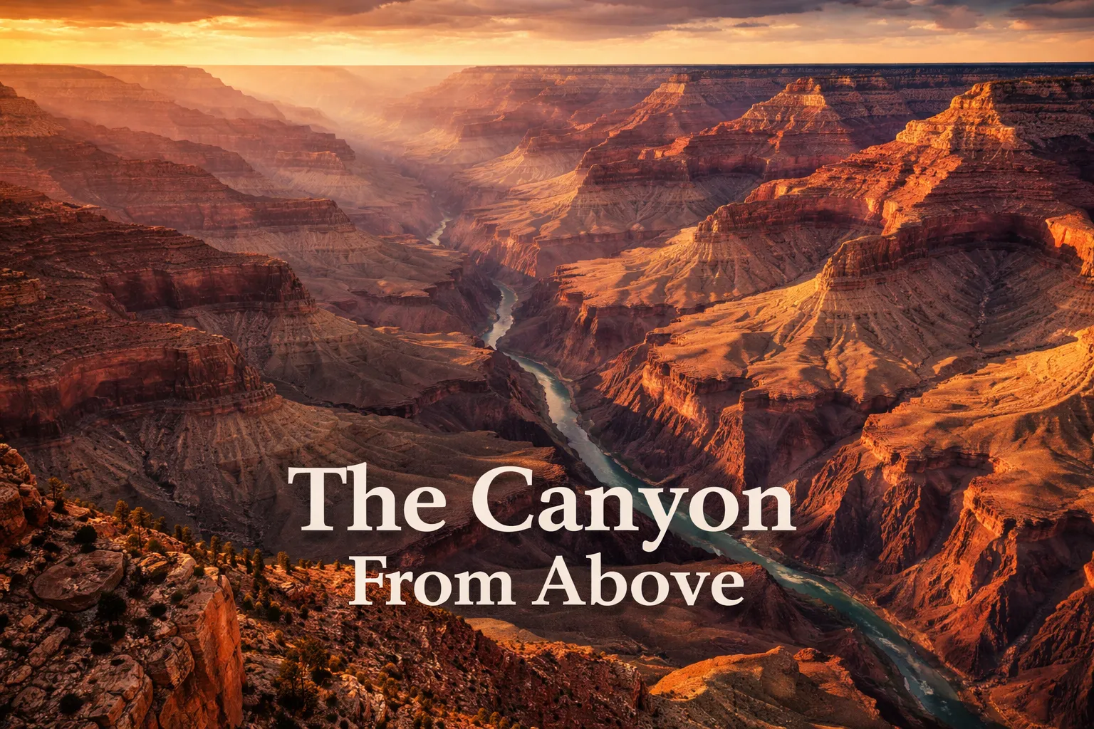
Can you actually launch a drone over the Grand Canyon and walk away with legal footage? Short answer: not inside the park, but yes, close by, if you know exactly where the boundary lines fall. I spent years leading groups through canyon country before I understood the place at all — standing at the South Rim staring down, I genuinely believed I’d grasped its scale. I hadn’t. That understanding didn’t arrive until I saw helicopter footage shot from 600 meters above the Colorado River, footage that finally showed what the canyon actually is: not a single downward plunge but a sprawling maze of side canyons, buttes, and stone amphitheaters running 446 kilometers from one end to the other. That’s precisely why grand canyon drone photography arizona ranks among the most-searched and most legally tangled aerial topics anywhere on earth. The mental image — a drone suspended over that impossible drop, lens creeping downward toward the green thread of river far below — is genuinely stunning. But before you even open your gear bag, there’s real legal groundwork to do here. This guide walks through both the fantasy and the paperwork, plus the exact spots where you can legally get aerial shots that hold up against anything you’ve scrolled past online.
Grand Canyon Drone Flight Brief
| Primary Location | Grand Canyon National Park, Arizona, USA |
| Park GPS Coordinates (South Rim) | 36.0544° N, 112.1401° W |
| Horseshoe Bend GPS (Legal Fly Zone) | 36.8791° N, 111.5100° W |
| Grand Canyon West / Skywalk GPS | 35.9912° N, 113.8132° W |
| Recommended Altitude Range | 120–300m AGL at legal alternative sites (see regulations below) |
| Best Time of Day | Golden hour (30 min after sunrise, 60 min before sunset) |
| Best Season | October–November (low crowds, warm light, chance of cloud inversions) |
| Drone Regulations Summary | ⛔ BANNED inside Grand Canyon National Park (NPS Policy). Legal alternatives exist on Navajo Nation land, Hualapai Reservation, and adjacent BLM land — with proper permissions. |
| Skill Level Required | Intermediate to Advanced (wind, thermals, high elevation, complex airspace) |
| Nearest FAA LAANC Coverage | Check FAA DroneZone / Aloft app before every flight |
Drone Rules Inside a National Park: What’s Actually Legal at the Grand Canyon
Here’s the plain truth of it: you cannot legally fly a drone anywhere within Grand Canyon National Park. The National Park Service shut down drone operations across all 423 US national park units back in 2014 through a policy memo, a rule later locked into site-specific regulations. At the Grand Canyon specifically, that prohibition covers launching, landing, and operating unmanned aircraft anywhere inside the park’s boundaries — full stop. Fines climb as high as $5,000, and rangers don’t look the other way on this one; I’ve watched confiscations happen firsthand at the South Rim. I get the pull — the overlooks are jaw-dropping, and you can practically visualize the shot your drone would capture. But the legal fallout, and the ethical cost, isn’t worth chasing that image. This park pulls in over 6 million visitors a year, protects habitat critical to the California condor, and enforces strict noise standards — drones step on all three at once.
Here’s the part that actually helps: grand canyon drone regulations national park boundaries don’t cover every jaw-dropping viewpoint in the surrounding region. This corner of the Southwest happens to have one of the more fascinating legal patchworks in the country, since several sovereign jurisdictions ring the park, each running its own rulebook. Translation: with the right research and the right permissions in hand, you can walk away with legal aerial footage that’s visually impossible to tell apart from anything shot inside park lines.
Legal Drone Spots Near the Grand Canyon: Where You’re Actually Allowed to Fly
Below are the spots I actually rely on for legal aerial work in and around Grand Canyon country. Each one comes with its own permission process and prep work, so don’t treat them interchangeably.
Horseshoe Bend (Glen Canyon National Recreation Area / BLM Land)
If I had to pick one legal aerial location for the whole Grand Canyon region, Horseshoe Bend near Page, Arizona wins without much argument. The Colorado carves a 270-degree bend here, dropping 300 meters below the sandstone rim, and hovering a drone at 150–200 meters directly above delivers a near-perfect composition every time — a horseshoe of dark green water wrapped in red-orange stone. The overlook straddles both BLM land and Glen Canyon NRA territory; the last time I checked, flying from the BLM-managed stretch near the main overlook trailhead was still permitted, while the NRA sections fall under the same NPS ban. Double-check current status with the Page BLM field office before you launch anything. Wind here turns unpredictable fast, especially once afternoon thermals start rising off the canyon walls, so get your flying done in the first two hours after sunrise.
Grand Canyon West / Hualapai Reservation
The Hualapai Tribe runs Grand Canyon West, and it sits fully outside NPS control. That makes it one of the best grand canyon drone alternatives for anyone serious about aerial work, since the Hualapai maintain their own commercial permitting system for drone and aerial photography. Skywalk and Eagle Point both look straight into a stretch of the western canyon with the Colorado visible far below. Commercial permits need to be applied for ahead of time and come with fees — reach out to the Hualapai Tourism Authority directly rather than guessing. Casual recreational flying without a commercial permit isn’t automatically green-lit, so don’t assume it’s fine. Do this the right way, though, and the payoff is real: angles into the western canyon that most visitors will never lay eyes on.
Navajo Nation Overlooks (East Rim / Desert View Area Vicinity)
The Navajo Nation holds land along stretches of the canyon’s eastern edge. Certain overlooks reachable from Highway 89 and the Navajo Route 20 corridor sit on tribal land, outside NPS jurisdiction entirely. Flying a drone here means securing explicit tribal permission first — this is sovereign land governed by its own legal system, not an extension of federal park rules. The Navajo Nation’s tourism office in Window Rock handles current permitting, so start there. Get the green light, and the eastern views from Navajo land show off a narrower, sharper-edged section of the canyon, with the Echo Cliffs and Painted Desert stretched across the horizon in wide shots.
Marble Canyon and Vermilion Cliffs (BLM Land)
Head north past the park boundary and you’ll hit Marble Canyon and the Vermilion Cliffs National Monument, a stretch of largely BLM-administered land where drone flights are generally fine as long as you’re following FAA rules. The Vermilion Cliffs deliver some of the most striking aerial geology anywhere in the Southwest — banded sandstone in crimson and orange, shaped by centuries of wind. A grand canyon aerial view from above doesn’t have to come from inside the park itself; Marble Canyon’s walls tell that same billion-year story in equally vivid detail.
Helicopter Aerial Photography Tours
If what you actually want is footage from directly over the canyon — legally — helicopter tours out of Grand Canyon Airport (GCN) and Las Vegas fly passengers above the gorge, and some operators offer open-door setups. Maverick Helicopters and Papillon Grand Canyon Helicopters both run configurations built specifically for photographers. From 600–900 meters up, the full drainage network reveals itself, with the Colorado twisting below like a thread of malachite against the terra-cotta rock. You can’t launch your own drone from the cabin, but a mirrorless camera or GoPro shooting through an open door produces results that genuinely hold up.
What You Actually See Looking Down From Above the Canyon
A grand canyon aerial view from above shows something no rim-level photo ever manages to convey: this isn’t one gorge, it’s a web. Hundreds of tributary canyons branch off the main corridor, spreading out like the root system of some massive tree. Standing at the rim, you’re looking at a single dramatic wall. From 300 meters up, you suddenly grasp that the canyon has depth stretching in every direction at once.
The layered rock coloring is what tends to stop first-time aerial viewers cold — it’s the real geological payoff. From altitude, you can pick out roughly 40 distinct rock bands, each one a marker of a different geological era. The Vishnu Schist at the very bottom runs nearly 2 billion years old, among the oldest exposed rock anywhere on the planet’s surface. Sitting above it, the Tapeats Sandstone shows as a brown ledge. Then greenish-grey Bright Angel Shale. Burgundy Redwall Limestone (which is naturally grey — that red comes from iron oxide bleeding down from higher layers). Deep red Supai Group. Brick-red Hermit Formation. Cream-white Coconino Sandstone. Then the Toroweap Formation, finishing with pale grey Kaibab Limestone right at the rim. Hover a drone at 200 meters and you catch all of it in one frame — a striped record of 2 billion years of planetary history.
From up high, the Colorado River at the canyon floor looks almost absurdly small — a green ribbon maybe 90 meters across in most stretches, dwarfed by walls towering 1,800 meters overhead. Algae and glacial silt give the water that distinctive green tint. In aerial shots, that contrast between green river and red rock becomes one of the most instantly recognizable visual signatures of the entire landscape.
Winter months (December through February) sometimes bring cloud inversions, when a white cloud sea pools inside the canyon below the rim line. Seen from above, the canyon looks stuffed with fog while the rim itself sits in bright, clear sunlight — a scene strange enough that footage of it tends to go viral almost automatically. Your best shot at catching one is arriving at the South Rim early in the morning right after a cold front passes through.
Shot List: Aerial Compositions and Camera Techniques Worth Trying
Straight Down Over Horseshoe Bend
Hold your drone at exactly 180 meters, centered directly above the meander. Shoot a nadir shot — straight down — to fit the entire horseshoe and river in frame. This works best at golden hour, when the walls glow orange and the water mirrors the sky. Aim for a focal length equivalent of 24mm or wider.
The Layered Canyon Wall Shot
From legal rim-adjacent spots, hold the drone at mid-wall height and shoot parallel to the cliff face, angled slightly upward. This is what shows off the color banding most clearly. Morning golden hour lights up the South Rim walls from the east; evening golden hour does the same for the North Rim from the west. Ideal altitude shifts by location, but plan on roughly 100–200 meters AGL.
The Pull-Back River Reveal
At Horseshoe Bend or the legal Marble Canyon sites: start low, around 30–40 meters, tightly framing the river, then slowly pull back while climbing to 200 meters. The resulting video reveals the full canyon context in a cinematic move that lands every single time. It only works in stable wind — keep it under 15 km/h before attempting this one.
Flying Above a Cloud Inversion
When a temperature inversion floods the canyon with cloud, fly just above the cloud layer at a legal site, camera pointed back toward the rim. What you get — a white cloud ocean with canyon walls rising out of it — ranks among the most surreal aerial shots available anywhere in North America. It requires winter timing, a cold front just having passed, and a fair bit of luck. December and January give you the best odds.
The Drone That Finally Got the Whole Canyon Into One Frame
Shooting the canyon from the rim is one experience; getting up to 120 meters, where the color bands actually separate out and the Colorado turns into a visible thread, is something else entirely. The trouble is that most drones either can’t climb high enough in the thin air out here or drop signal right before you get the shot you’re after.
Where it delivers
- The dual-camera rig (48MP Hasselblad plus a 162mm telephoto) let me frame the whole amphitheater in a single shot, then punch in on one lone butte without any loss of detail — genuinely necessary when the terrain keeps changing scale on you.
- Battery performance held up even past 6,700 feet, where thin air usually punishes drones badly; I consistently got 20-minute flight windows instead of the anxiety-inducing 12-minute cutoffs I’ve dealt with on cheaper models.
- Signal held firm even weaving through the canyon’s stacked rock walls and wind shear — conditions that would’ve dropped connection on a lesser controller. I never hit that gut-drop moment of losing the link mid-flight.
Where it falls short
- Starting at $1,900+, this isn’t an impulse buy, and the learning curve is genuinely steep — my entire first afternoon went to sorting out gimbal settings rather than shooting anything, which stings when your canyon time is already limited.
- Rim winds don’t let up, and even this stabilized unit gets shoved around once gusts pass 25 knots; you’ll lose shots to fighting for altitude, not because the camera itself failed you.
There was one afternoon when I thought I’d overtaxed the battery at altitude and watched the voltage warning flash as I descended toward the rim—my hands went cold until the landing pad came into view. If you’re serious about drone photography at the Grand Canyon, the DJI Mavic 3 Pro with RC is the only tool that won’t force you to choose between ambition and a safe flight home.
Frequently Asked Questions
Can I legally fly a drone inside Grand Canyon National Park?
No. You cannot legally fly a drone anywhere within Grand Canyon National Park—launching, landing, and operating unmanned aircraft are all banned inside the park’s boundaries. Fines climb as high as $5,000, and the National Park Service enforces this rule strictly across all 423 US national park units.
Where can I legally fly a drone near the Grand Canyon?
Legal alternatives exist on Horseshoe Bend near Page (BLM land and Glen Canyon NRA), Grand Canyon West on the Hualapai Reservation, Navajo Nation overlooks along the eastern rim, and Marble Canyon and Vermilion Cliffs National Monument on BLM land. Each location requires different permissions, so check with the appropriate office before flying.
What altitude should I fly my drone at the Grand Canyon?
The recommended altitude range at legal alternative sites is 120–300 meters AGL. At Horseshoe Bend, hovering at 150–200 meters directly above delivers a near-perfect composition. For layered canyon wall shots, plan on roughly 100–200 meters AGL depending on your location.
What’s the best time to fly a drone at the Grand Canyon?
Golden hour—30 minutes after sunrise or 60 minutes before sunset—offers the best light. October through November provide the ideal season with low crowds, warm light, and a chance of cloud inversions. Winter months (December through February) offer the best odds for capturing cloud inversions inside the canyon.
About This Article

Written by Elena Vasquez. Elena Vasquez is a full-time traveler and the founder of Witty Passport. Over fifteen years and more than 50 countries across six continents — including a stretch spent leading groups professionally through Southeast Asia and the remote highlands of South America — she's written the kind of destination guides she always wished existed: practical, specific, and built on real experience rather than recycled itineraries. More about this site.
Scope and limits. Elena is a full-time traveler, not a licensed travel agent or immigration adviser. Entry requirements, visa rules, and advisories change without notice — always confirm against the official government source for your destination and passport before booking.
Verify this against a primary source
Specifics change, and your situation may differ from the one described here. These are the authorities worth checking directly:
- U.S. Department of State — entry requirements and travel advisories
- CDC Travelers' Health — vaccination and health notices by destination
- TSA — current carry-on and screening rules