
This post contains affiliate links. As an Amazon Associate, I earn from qualifying purchases at no extra cost to you.
Mount Roraima Drone Photography: Earth’s Lost World From Above
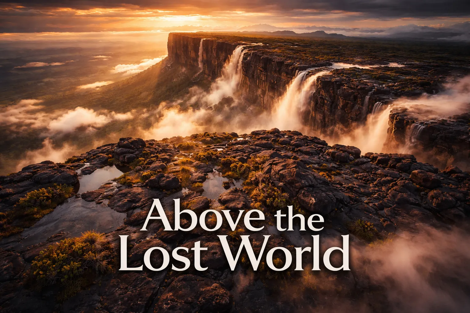
The first time my drone cleared the treeline at the base of Mount Roraima and the summit plateau came into view on my controller screen, I genuinely thought my FPV feed had glitched. Nothing in twenty years of aerial photography had prepared me for what mount roraima drone photography venezuela delivers: a flat-topped mountain the size of a small city, ringed by 400-meter vertical cliffs, wrapped in its own personal weather system, looking less like Earth and more like a forgotten planet suspended above the Gran Sabana. This is the tepui that made Arthur Conan Doyle write The Lost World. From above, you understand exactly why.
Drone Flight Brief: Mount Roraima At-a-Glance
| GPS Coordinates (Summit Plateau) | 5.1438° N, 60.7625° W |
| Elevation | 2,810 m (9,219 ft) above sea level |
| Recommended Altitude Range | 50–180 m AGL above summit; 300–500 m AGL from base approaches |
| Best Time of Day to Fly | 05:30–08:00 AM — before daily cloud formation engulfs the summit |
| Best Season | December–April (dry season); February is peak clarity |
| Drone Regulations — Venezuela | INAC (Venezuela’s civil aviation authority) requires prior authorization for drone operation; enforcement is highly unpredictable; most commercial drone operators currently avoid Venezuelan access routes entirely |
| Drone Regulations — Brazil (Pacaraima approach) | ANAC/DECEA approval required; recreational drones under 250g may have simplified requirements; always file a SARPAS flight plan via DECEA |
| Drone Regulations — Guyana | Guyana Civil Aviation Authority (GCAA) requires a permit for drone operations; apply minimum 30 days in advance |
| Skill Level Required | Advanced — high altitude, extreme weather, GPS interference reported on summit, no rescue infrastructure |
| Difficulty Rating | ⬛⬛⬛⬛⬜ 4/5 — Expert terrain |
What the Mount Roraima Aerial View Reveals That Ground-Level Hikers Never See
Standing at the base of Roraima, you see a wall. An enormous, ancient, moss-streaked wall. That’s essentially it. The mountain keeps its secrets from ground-level observers with almost deliberate contempt. The mount roraima aerial view tepui experience is categorically different. At 300 meters above the summit plateau, the 31-square-kilometer tabletop unfolds in its full alien complexity. The surface isn’t flat at all — it’s a labyrinth of black quartz rock formations called “Roraima tepui karst,” riddled with pools of tannin-stained water that photograph as deep amber and rust against the dark rock.
The waterfalls are perhaps the greatest revelation. Roraima hosts some of the world’s tallest free-falling waterfalls — several exceed 300 meters — but from the ground they’re largely invisible because they dissipate entirely into mist and updrafts before reaching the base. Only from the air do you see the full cascade: the white thread leaving the plateau rim, the explosion into spray at mid-cliff, the ghostly veil where water becomes fog. I spent an entire morning at 250 meters tracking one unnamed fall on the Venezuelan face, and the footage still doesn’t fully convey how surreal it is.
The three-country border point — where Venezuela, Brazil, and Guyana meet at the summit’s southern tip — is another feature that only makes visual sense from altitude. The “Valley of Crystals” (Valle de los Cristales), a section of the summit littered with quartz crystals and rose quartz formations, shows up in aerial imagery as a pale, almost glittering swath cutting through the dark plateau surface. And the endemic vegetation — carnivorous plants, tiny orchids, species found nowhere else on Earth on a 2-billion-year-old geological surface — creates a texture in aerial photography that looks genuinely prehistoric.
The Best Shots to Capture: Gran Sabana Drone Photography Compositions
Gran sabana drone photography rewards patience and early starts above everything else. The shot most photographers chase — and the one that justifies every logistical nightmare of getting here — is the “island above the clouds” composition. This requires positioning your drone at approximately 400–600 meters above the summit (which places you at roughly 3,200–3,400 meters absolute altitude) during the brief morning window when the surrounding Gran Sabana lowlands are still filled with low cloud. Roraima’s summit breaks through above the cloud sea, and you have perhaps 45 minutes before the cloud rises to engulf the plateau itself.
For the cliff face waterfalls, fly parallel to the escarpment at 50–100 meters above the plateau rim and position your camera at a 45-degree downward angle toward the cliff face. The morning light hitting the east-facing Venezuelan escarpment between 06:00–08:00 creates dramatic raking shadows across the vertical rock that reveal geological layering invisible in flat light. For the tabletop mountain venezuela from above perspective that shows the full scale of the plateau, you need significant altitude — 500 meters AGL minimum — with the drone positioned roughly 2 kilometers from the nearest cliff edge, shooting inward with a wide focal length equivalent.
The summit karst pools photograph best at a near-vertical 80–90 degree nadir angle from 80–120 meters, ideally in overcast light (which you’ll have plenty of) to eliminate harsh reflections. The amber-black color contrast in these pools is unlike anything else in aerial photography. Shoot in RAW, bracket your exposures, and plan to spend serious time in post — the tonal range between the black rock, the luminous pools, and the white cloud wisps overhead is extreme.
Can You Fly a Drone at Mount Roraima? Regulations and Practical Reality
This requires an honest answer, because the situation is genuinely complicated. On paper, drone flight at Mount Roraima requires authorization from whichever country’s airspace you’re operating in — Venezuela (INAC), Brazil (ANAC/DECEA), or Guyana (GCAA). None of these are quick processes, and Venezuela’s current political and infrastructure situation makes obtaining reliable INAC authorization extremely difficult for foreign nationals. Most serious drone photographers I know who have shot Roraima in recent years have approached exclusively from Brazil via the town of Pacaraima in Roraima State, trekking through Canaima National Park’s Brazilian access point.
Brazil’s DECEA SARPAS system is functional and navigable — file your flight plan, carry your documentation, and be prepared to show it to any park rangers encountered on the multi-day approach trek. The summit itself sits within Venezuela’s Canaima National Park (a UNESCO World Heritage Site), which adds another regulatory layer. Venezuela has a general prohibition on unauthorized drone flight within national parks. The practical enforcement reality at a summit that takes 4–6 days of trekking to reach is a different matter, but operating without authorization carries real legal and ethical risk — I am not suggesting you ignore regulations, and this is not legal advice. Get your paperwork in order before you go.
The lost world mountain drone photography community largely operates in a legal gray zone here, and it’s worth being clear-eyed about that. If you’re shooting commercially, the stakes are higher and full authorization is non-negotiable. If you’re flying a sub-250g drone recreationally under Brazilian airspace from the Brazilian approach, the regulatory burden is somewhat lighter, but “somewhat lighter” is not “unrestricted.” Altitude-wise, note that the summit plateau at 2,810m significantly reduces drone performance — expect roughly 20–30% reduction in flight time and lift capacity compared to sea-level specs.
Best Time to Photograph Mount Roraima From Above
Mount Roraima creates its own microclimate and receives rain approximately 300 days per year — this is not a location where you book a flight and expect cooperative weather. The dry season (December through April) offers the best probability of clear morning windows, with February and March being the statistical peak for summit visibility. Even in dry season, the summit is typically enveloped in cloud by 10:00–11:00 AM. Your operational window for aerial photography is the two to three hours after dawn, and you will not get this every day. Budget at least three to four days at summit camp to maximize your chances of catching a clear morning.
The wet season (May–November) doesn’t make photography impossible — some of the most dramatic images of Roraima come from storm light and partial cloud clearances — but flight windows become rare and unpredictable, and the increased precipitation creates serious risks for electronics. If you visit in the shoulder season (late November or late April), you may catch transitional weather that offers dramatic cloud formations without constant saturation. Whatever season you choose, pack serious waterproofing for every piece of electronic equipment you bring.
Gear Worth Packing for High-Altitude Tepui Drone Photography
At 2,810 meters in a permanently humid, frequently violent weather environment, your gear choices matter more here than almost anywhere else I’ve photographed. The multi-day trek approach means every gram is scrutinized, but there are items where cutting weight is a false economy.
Propeller failure at altitude is a scenario nobody wants, and at Roraima it means a lost or destroyed drone with zero possibility of immediate replacement — the nearest drone parts store is days of trekking and a long drive away. The 8Pcs HS175D Propellers replacement set is the kind of redundancy kit that experienced expedition drone pilots carry without thinking twice. On my second Roraima approach, I clipped a quartz rock formation during a low pass in poor visibility — a scenario entirely predictable given the summit’s jagged terrain — and having a full set of replacement propeller blades meant I was back in the air the same morning rather than scrapping the rest of the shoot. At altitude, prop efficiency is already compromised, and even a minor nick in a blade causes vibration artifacts in your footage that ruin otherwise perfect shots. Carry spares for your specific drone model the same way you’d carry spare batteries: not because you expect to need them, but because the one time you don’t have them is the time you need them most. This specific set covers multiple popular drone platforms and the compact packaging adds negligible weight to a trekking pack.
For photographers who are new to aerial work and considering Roraima as an aspirational destination while building their skills, the 2K HD FPV Camera Drone with Altitude Hold represents a genuinely practical entry point for learning the fundamentals of aerial composition before committing to a serious expedition-grade platform. The altitude hold feature in particular is worth calling out: when I’ve mentored newer drone pilots, the single biggest challenge in early aerial photography isn’t framing or exposure — it’s maintaining stable hover while you focus on composition, and altitude hold automates exactly that. Roraima itself demands advanced skills and should not be a beginner’s first location, but building your compositional eye and weather-reading instincts on a forgiving, approachable platform like this one — at easier locations first — is how you arrive at Roraima ready for what it demands. The dual-battery setup extends practice sessions meaningfully, and the one-key landing function is genuinely useful when sudden cloud intrusion or wind change requires rapid recovery.
For FPV and multirotor operators running larger platforms at Roraima — particularly those shooting with cinema-grade quad builds capable of carrying mirrorless cameras for maximum image quality — high-quality propeller sets are load-bearing equipment in the most literal sense. The SoloGood 1045 10-inch FPV Propellers (16-piece set, CW and CCW) are a staple in serious expedition builds for good reason. At summit altitude, larger props that can move more air efficiently are a significant advantage over undersized alternatives — the reduced air density at 2,810 meters means your motors are working harder for every gram of lift, and prop geometry becomes a performance variable rather than an afterthought. The 8 clockwise and 8 counter-clockwise configuration in this set covers full quad replacement with four spares, which is exactly the redundancy math you want for a location where resupply is impossible. The red and black color coding is a small detail that matters in field conditions — identifying CW versus CCW props quickly in cold, wet, pre-dawn summit light without adequate coffee is harder than it sounds, and color coding eliminates a category of assembly error entirely.
Frequently Asked Questions About Mount Roraima Drone Photography
Is drone photography legal at Mount Roraima?
Drone operation at Mount Roraima requires authorization from the relevant civil aviation authority of the country through which you’re approaching — Venezuela (INAC), Brazil (ANAC/DECEA), or Guyana (GCAA). The summit sits within Venezuela’s Canaima National Park (UNESCO World Heritage Site), which adds additional permit requirements. Most photographers currently access via Brazil and file with Brazil’s DECEA SARPAS system. Operating without authorization is illegal and ethically problematic in a protected natural heritage site. Always obtain proper permits before flying — regulations and enforcement can change, so verify current requirements with each country’s aviation authority before your trip.
How does high altitude affect drone performance at Mount Roraima?
At 2,810 meters (9,219 feet) above sea level, the air density is significantly lower than at sea level — approximately 73% of sea-level density. This means drone rotors generate less lift for the same RPM, motors run hotter, and battery performance decreases in the cold summit temperatures (often 5–15°C). In practical terms, expect 20–30% reduction in maximum flight time compared to manufacturer specs, reduced payload capacity, and less responsive handling in strong summit winds. Use larger propellers where your platform supports them, carry extra batteries, keep batteries warm in insulated pouches before flight, and plan shorter flight sessions with longer recovery periods between them.
What is the best time of year for Mount Roraima aerial photography?
The dry season from December through April offers the highest probability of clear morning windows on the summit. February is statistically the best single month for summit visibility. Even in dry season, cloud typically engulfs the plateau by mid-morning, so the operational window for aerial photography is approximately 05:30–10:00 AM. Budget a minimum of three to four days at summit camp to improve your chances of catching clear conditions. The wet season (May–November) is not impossible but offers dramatically fewer flight opportunities and greater risk to electronics from persistent rain and mist.
What makes the Mount Roraima summit look so alien from above?
Mount Roraima’s summit is one of the oldest exposed geological surfaces on Earth, estimated at approximately 2 billion years old. The 31-square-kilometer plateau consists of Precambrian sandstone and quartz formations that have been sculpted by wind, rain, and biological processes into bizarre karst-like formations found nowhere else. The summit hosts an entirely endemic ecosystem — species that evolved in total isolation on the tepui and exist nowhere else on Earth, including carnivorous plants, unique frog species, and strange orchids. The combination of dark ancient rock, amber tannin-stained pools, white quartz crystal fields, and endemic vegetation emerging from constant cloud cover produces aerial imagery that genuinely resembles extraterrestrial landscapes.
How do you physically get to Mount Roraima for drone photography?
The most practical current access route for international photographers is via Brazil: fly to Boa Vista in Roraima State, Brazil, then travel to the border town of Pacaraima and into the Canaima region. The standard trek to the Roraima summit takes approximately four to six days round trip from the Brazilian trailhead, covering roughly 35 kilometers with significant elevation gain. The Venezuelan access route through Ciudad Guayana and Canaima National Park, once the primary approach, is currently considered high-risk for foreign travelers due to Venezuela’s ongoing political and security situation — check your government’s current travel advisories before making any plans. Guided tours with reputable operators from the Brazilian side are strongly recommended for first-time visitors.