
| Detail | Information |
|---|---|
| GPS Coordinates (center of salar) | 20°08′ S, 67°29′ W |
| Recommended Altitude Range | 30–150m for mirror compositions; 100–300m for geometric salt patterns and wide landscape shots |
| Best Time of Day to Fly | 30 minutes after sunrise (golden light on the salt crust) and 45 minutes before sunset; avoid midday (harsh white overexposure) |
| Best Season (Wet) | December–April for the mirror effect; peak reflection January–March |
| Best Season (Dry) | May–November for hexagonal salt patterns, starker shadows, and Milky Way shoots |
| Drone Regulations Summary | Bolivia has no dedicated national drone law as of 2025; DGAC (Dirección General de Aeronáutica Civil) technically oversees airspace. Recreational drones under 25kg are generally tolerated with no formal permit required for the open salar. Commercial operators should seek DGAC clearance. Always confirm current rules before departure. |
| Skill Level Required | Intermediate to Advanced — altitude reduces battery performance by 20–30%, featureless terrain causes GPS drift, and white surface causes severe exposure metering errors |
| Nearest Town | Uyuni (approx. 25km east of salar edge) |
What the Salar de Uyuni Aerial Mirror Effect Actually Looks Like From Above
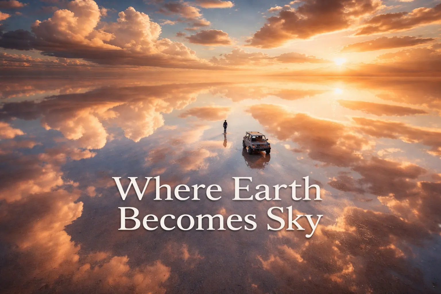
From ground level, the wet-season mirror effect is breathtaking but still comprehensible — you are standing on a reflective surface looking outward at a horizon. From a drone, the experience is categorically different. At around 80 meters, the reflection is so complete and so geometrically perfect that the brain simply refuses to assign a “floor” and a “ceiling” to the scene. The salar de uyuni aerial mirror effect from a drone perspective creates a sphere of sky — clouds replicated above and below in identical detail, with your drone appearing to float at the exact midpoint of an infinite blue void. A single jeep or a lone human figure standing on the salt becomes an astronaut untethered from any surface, suspended in atmosphere. The visual information that normally tells us “this is the ground” — texture, shadow, horizon — is entirely absent.
During the dry season, a completely different kind of wonder takes over. The bolivia salt flats from above drone reveal what ground-level visitors can only partially appreciate: the entire surface is tessellated into hexagonal cells, each cell between 1 and 2.5 meters across, created by the expansion and contraction of salt as it dries. From 200 meters up, these hexagons tile every direction to the absolute edge of visibility. It looks less like Earth and more like a close-up of a wasp nest scaled to continental proportions. There is no other place on the planet where geology produces this pattern at this scale and this altitude. The drone is the only tool that reveals the full geometry.
The Best Shots to Capture: Salar de Uyuni Drone Photography Bolivia
The Floating Figure Shot (Wet Season, 40–60m)
This is the image that launched a thousand travel influencer accounts and it still delivers every single time. Position your subject — a person, a vehicle, a local guide on a bicycle — in the center of the frame. Fly to approximately 40–60 meters and shoot straight down at nadir (directly overhead). The reflection eliminates the horizon entirely, and your subject appears to float in open sky. The best light for this shot is the first 90 minutes after sunrise, when the sky carries warm tones that saturate beautifully in the reflection. Overcast days, counterintuitively, also produce stunning results because the flat, diffused light creates a white infinity environment rather than a blue one — your subject becomes a silhouette in pure white nothingness.
Isla Incahuasi Cacti at Scale (Dry Season, 150–300m)
Isla Incahuasi (also called Isla del Pescado) is a rocky island rising from the center of the salar, covered in ancient columnar cacti that can reach 10 meters in height, growing at approximately 1 centimeter per year — some are estimated to be 900–1,200 years old. From the air, the island looks like a single dark brushstroke on an infinite white canvas. The best composition comes from 200–300 meters at a 45-degree downward angle, positioned so the island sits in the lower third of the frame with the vast white salar filling the remaining two-thirds. This is the definitive scale shot: the island is roughly 1.5 kilometers long, and the salar surrounding it stretches another 100+ kilometers in every direction. The cacti provide that crucial textural detail that stops the image from becoming an abstract.
The Uyuni Train Cemetery at Dusk (Year-Round, 30–100m)
About 3 kilometers outside the town of Uyuni sits a graveyard of steam locomotives and rail carriages — industrial relics from the 19th and early 20th century, rusting beautifully in the altiplano desert. The railway cemetery is technically outside the salar proper but is a standard stop on any Uyuni tour and is extraordinarily photogenic from the air. At dusk, the low-angle warm light rakes across the corroded metal and throws long shadows across the flat ground. Fly at 30–80 meters and use a shallow angle to compress the perspective — line the locomotives up so they appear to march into the distance. This is the industrial gothic counterpoint to the ethereal salar, and the combination of otherworldly rust and otherworldly white makes it one of the best drone landscapes south america has to offer.
Milky Way Over the Mirror (Wet Season, 10–30m)
The Salar de Uyuni sits at one of the darkest sky locations in the Southern Hemisphere — light pollution from Uyuni town is minimal and the flat terrain offers a 360-degree unobstructed horizon. During the wet season on a moonless night, the Milky Way reflects in the water layer with the same fidelity as the daytime sky. Flying a drone at very low altitude — 10 to 30 meters — with a long exposure captures the galaxy arching above and its perfect double below. This is technically demanding work: you need a drone with strong low-light performance, you must manually set exposure, and you need a remote trigger or interval timer function. The result is one of the rarest composite images in aerial photography — a subject surrounded by stars on all sides.
Can You Fly a Drone at Salar de Uyuni? Regulations and Practical Reality
Bolivia’s regulatory environment for drone photography salt flats is among the most permissive in South America — largely because specific national legislation governing small recreational and prosumer drones has been slow to materialize. As of early 2025, Bolivia’s DGAC (Dirección General de Aeronáutica Civil) oversees national airspace, but the salar itself falls under no protected area designation that specifically prohibits drone flight. The vast open terrain means there are no airspace conflicts with commercial aviation at low altitudes. In practice, the hundreds of photographers who visit annually fly freely across the salar with no official interference. That said, the regulatory landscape in South America can shift, and any commercial operator — shooting for clients, licensing imagery, or producing content for brand campaigns — should proactively contact DGAC and ideally secure written clearance before arriving. I always recommend checking the current rules on official DGAC Bolivia channels and with your tour operator within 60 days of your trip.
The practical challenges at the salar are more significant than the regulatory ones. At 3,656 meters above sea level, the thinner air means your drone’s motors must work harder to generate the same lift as at sea level — most pilots report a 20–30% reduction in battery flight time. What your drone lists as a 31-minute battery life becomes approximately 21–24 minutes at salar altitude. Always carry every battery you own, keep them warm in an interior jacket pocket before flying (cold temperatures further reduce capacity), and set your return-to-home battery threshold conservatively. The white salt surface also creates severe exposure metering problems — your drone’s auto-exposure system will try to compensate for the brightness by underexposing, turning your blue sky gray. Shoot in manual exposure mode or dial in significant positive exposure compensation (+1.5 to +2 EV) and review your histogram obsessively. Finally, the featureless white terrain makes GPS positioning less reliable — the drone’s visual positioning system has nothing to lock onto, so fly in GPS mode and keep your aircraft in close visual range at all times.
Gear Worth Packing for Salar de Uyuni Aerial Photography
The salar’s environment is hostile to camera equipment in ways that are easy to underestimate. The fine salt dust that lifts off the surface in any wind will infiltrate camera systems without protection — and at Uyuni, you are dealing with salt, which is corrosive in ways that regular dust simply is not. If you are flying a DJI Avata 2, the Freewell UV Filter for the Avata 2 is genuinely one of the most important items in my bag. This filter protects the lens from the fine salt particulate and airborne grit that inevitably reaches the camera during low-altitude passes over the salar — even in calm conditions, the jeep traffic and wind create a constant low-level suspension of salt crystals. Beyond dust protection, it also blocks UV radiation, which is intense at 3,656 meters elevation where the atmosphere is thinner and UV levels measurably higher than at sea level. I scratched a lens at Uyuni before I started using UV protection consistently, and I will never make that mistake again — the filter costs a fraction of what a lens replacement does. The Freewell’s multicoated optical glass design ensures you are not trading dust protection for optical degradation.
If you are flying a DJI Mini 5 Pro — which is an excellent choice for Uyuni given its compact travel size and strong camera performance — the NEEWER UV Filter for the DJI Mini 5 Pro is what I recommend for lens protection on this specific platform. The snap-on design is crucial at Uyuni because you are constantly switching between flight sessions and the mounting and dismounting process needs to be fast and reliable — your hands are cold, your fingers are less agile at altitude, and fiddly filter systems cost you shooting time during the critical golden hour windows that last only 30–40 minutes. The multicoated optical glass maintains the Mini 5 Pro’s excellent image quality without introducing flare or color cast on the reflective white surface — a real concern when your lens is pointed at a surface that is essentially a giant mirror. I keep mine on for every single flight at Uyuni regardless of conditions, removing it only for nighttime Milky Way work where you want maximum light transmission.
For DJI Neo 2 pilots, the Freewell UV Filter for the DJI Neo 2 addresses the same core problem with a solution matched to that specific camera system. The Neo 2 is increasingly popular among travel photographers who want a compact, capable drone for destinations exactly like Uyuni — light enough to carry in a daypack, capable enough to shoot professional-quality footage. The Freewell UV filter for this platform blocks ultraviolet light that causes haze and color shift in footage shot at high-altitude locations like the salar, where UV is significantly more intense than at sea level and visibly affects color grading in post-production. I have shot comparison footage at Uyuni with and without UV filtration on compact drones and the difference in footage clarity and color accuracy — particularly in the blue sky reflections that define the mirror effect shots — is visible without pixel-peeping. The protection against salt particulate ingestion is equally important here as on any other platform; small drones are not immune to the corrosive effects of flying through salty air.
Best Time to Photograph Salar de Uyuni From Above
The answer depends entirely on what image you are chasing. For the salar de uyuni aerial mirror effect, you need the wet season: December through April, with January through March delivering the most consistent and deepest water coverage. A layer of just a few centimeters of water is all that is needed for the reflection — in fact, shallower water often produces a cleaner, less disturbed mirror surface than deeper flooding. The challenge is that the wet season brings weather variability: heavy rain, afternoon cloud buildup, and occasional thunderstorms can ground you for days. The optimal window is early morning on a clear day following a rain event, when the water is settled and the sky is clear.
For the hexagonal salt pattern geometry and the ultra-clean, otherworldly alien-landscape aesthetic, the dry season — May through November — is superior. The salt surface is stable, the skies are reliably clear, and the low-humidity atmosphere produces extraordinary long-range visibility. May and June offer the advantage of cooler temperatures (better for battery performance) while the salar surface is still showing crisp hexagonal definition before the dry-season dust begins to soften edges. September and October are excellent for Milky Way night shoots because the nights are long and cold — cold air reduces humidity and improves sky clarity further. Whichever season you choose, arrive two days before your planned shoot: altitude acclimatization genuinely affects your performance and decision-making, and you want to be sharp during those critical early morning windows.
Frequently Asked Questions
Is drone flying legal at Salar de Uyuni in Bolivia?
As of early 2025, Bolivia has no specific national law prohibiting recreational or prosumer drone flight at the Salar de Uyuni. The salar is not a designated protected park that bans aerial devices. Bolivia’s DGAC oversees national airspace, and small drones are generally tolerated at the salar without permits for personal use. Commercial operators should seek DGAC clearance before shooting. Always verify current regulations directly with DGAC Bolivia and your local tour operator before your trip, as aviation rules can change.
How does altitude affect drone performance at Salar de Uyuni?
The salar sits at 3,656 meters (11,995 feet) above sea level. At this altitude, the thinner air reduces rotor efficiency, and most drones experience a 20–30% reduction in battery flight time compared to sea-level performance. A drone rated for 31 minutes of flight will typically deliver 21–24 minutes at the salar. Cold temperatures compound this further. Carry every available battery, keep them warm in a body-temperature pocket before use, and set conservative return-to-home battery percentage thresholds — 30% rather than the standard 20% is a safe practice at altitude.
What is the best season for the mirror effect at Salar de Uyuni?
The wet season runs December through April, with the peak mirror effect occurring January through March. Rainfall deposits a thin layer of water — even just 1–5 centimeters — over the salt crust, creating a nearly perfect reflective surface. The most photogenic conditions occur on clear mornings following recent rain, when the water has settled and cloud cover is minimal. The reflection is so complete that from drone altitude, the horizon disappears entirely and the sky is visible both above and below the aircraft simultaneously.
Why does exposure metering fail on the white salt flats?
Drone cameras — like all cameras — meter exposure by trying to render the scene as middle gray. The brilliant white salt surface is far brighter than middle gray, so the camera’s auto exposure system responds by reducing exposure, which results in underexposed skies and an overall gray, flat-looking image. The fix is to shoot in manual exposure mode or dial in strong positive exposure compensation
The moment my drone cleared forty meters above the Salar de Uyuni, I genuinely lost my bearings. Not because of the altitude — though at 3,656 meters above sea level, the air was thin enough to make every walk back to the jeep feel like punishment — but because the screen in my hands stopped making visual sense. The horizon had vanished. Sky was below me. The drone appeared to be hovering inside a cloud. This is what salar de uyuni drone photography bolivia actually feels like: a full-system override of your spatial reasoning, delivered through a 6-inch monitor on a freezing altiplano morning. Nothing I had read, and nothing I had seen in other people’s footage, fully prepared me for the psychological disorientation of watching my aircraft float through an infinite reflection. The Salar de Uyuni — 10,582 square kilometers of ancient salt crust sitting in the southwestern corner of Bolivia — is, without question, the most mind-bending drone landscape on Earth.
This post contains affiliate links. As an Amazon Associate, I earn from qualifying purchases at no extra cost to you.
Drone Flight Brief: Salar de Uyuni at a Glance
| Detail | Information |
|---|---|
| GPS Coordinates (center of salar) | 20°08′ S, 67°29′ W |
| Recommended Altitude Range | 30–150m for mirror compositions; 100–300m for geometric salt patterns and wide landscape shots |
| Best Time of Day to Fly | 30 minutes after sunrise (golden light on the salt crust) and 45 minutes before sunset; avoid midday (harsh white overexposure) |
| Best Season (Wet) | December–April for the mirror effect; peak reflection January–March |
| Best Season (Dry) | May–November for hexagonal salt patterns, starker shadows, and Milky Way shoots |
| Drone Regulations Summary | Bolivia has no dedicated national drone law as of 2025; DGAC (Dirección General de Aeronáutica Civil) technically oversees airspace. Recreational drones under 25kg are generally tolerated with no formal permit required for the open salar. Commercial operators should seek DGAC clearance. Always confirm current rules before departure. |
| Skill Level Required | Intermediate to Advanced — altitude reduces battery performance by 20–30%, featureless terrain causes GPS drift, and white surface causes severe exposure metering errors |
| Nearest Town | Uyuni (approx. 25km east of salar edge) |
What the Salar de Uyuni Aerial Mirror Effect Actually Looks Like From Above
From ground level, the wet-season mirror effect is breathtaking but still comprehensible — you are standing on a reflective surface looking outward at a horizon. From a drone, the experience is categorically different. At around 80 meters, the reflection is so complete and so geometrically perfect that the brain simply refuses to assign a “floor” and a “ceiling” to the scene. The salar de uyuni aerial mirror effect from a drone perspective creates a sphere of sky — clouds replicated above and below in identical detail, with your drone appearing to float at the exact midpoint of an infinite blue void. A single jeep or a lone human figure standing on the salt becomes an astronaut untethered from any surface, suspended in atmosphere. The visual information that normally tells us “this is the ground” — texture, shadow, horizon — is entirely absent.
During the dry season, a completely different kind of wonder takes over. The bolivia salt flats from above drone reveal what ground-level visitors can only partially appreciate: the entire surface is tessellated into hexagonal cells, each cell between 1 and 2.5 meters across, created by the expansion and contraction of salt as it dries. From 200 meters up, these hexagons tile every direction to the absolute edge of visibility. It looks less like Earth and more like a close-up of a wasp nest scaled to continental proportions. There is no other place on the planet where geology produces this pattern at this scale and this altitude. The drone is the only tool that reveals the full geometry.
The Best Shots to Capture: Salar de Uyuni Drone Photography Bolivia
The Floating Figure Shot (Wet Season, 40–60m)
This is the image that launched a thousand travel influencer accounts and it still delivers every single time. Position your subject — a person, a vehicle, a local guide on a bicycle — in the center of the frame. Fly to approximately 40–60 meters and shoot straight down at nadir (directly overhead). The reflection eliminates the horizon entirely, and your subject appears to float in open sky. The best light for this shot is the first 90 minutes after sunrise, when the sky carries warm tones that saturate beautifully in the reflection. Overcast days, counterintuitively, also produce stunning results because the flat, diffused light creates a white infinity environment rather than a blue one — your subject becomes a silhouette in pure white nothingness.
Isla Incahuasi Cacti at Scale (Dry Season, 150–300m)
Isla Incahuasi (also called Isla del Pescado) is a rocky island rising from the center of the salar, covered in ancient columnar cacti that can reach 10 meters in height, growing at approximately 1 centimeter per year — some are estimated to be 900–1,200 years old. From the air, the island looks like a single dark brushstroke on an infinite white canvas. The best composition comes from 200–300 meters at a 45-degree downward angle, positioned so the island sits in the lower third of the frame with the vast white salar filling the remaining two-thirds. This is the definitive scale shot: the island is roughly 1.5 kilometers long, and the salar surrounding it stretches another 100+ kilometers in every direction. The cacti provide that crucial textural detail that stops the image from becoming an abstract.
The Uyuni Train Cemetery at Dusk (Year-Round, 30–100m)
About 3 kilometers outside the town of Uyuni sits a graveyard of steam locomotives and rail carriages — industrial relics from the 19th and early 20th century, rusting beautifully in the altiplano desert. The railway cemetery is technically outside the salar proper but is a standard stop on any Uyuni tour and is extraordinarily photogenic from the air. At dusk, the low-angle warm light rakes across the corroded metal and throws long shadows across the flat ground. Fly at 30–80 meters and use a shallow angle to compress the perspective — line the locomotives up so they appear to march into the distance. This is the industrial gothic counterpoint to the ethereal salar, and the combination of otherworldly rust and otherworldly white makes it one of the best drone landscapes south america has to offer.
Milky Way Over the Mirror (Wet Season, 10–30m)
The Salar de Uyuni sits at one of the darkest sky locations in the Southern Hemisphere — light pollution from Uyuni town is minimal and the flat terrain offers a 360-degree unobstructed horizon. During the wet season on a moonless night, the Milky Way reflects in the water layer with the same fidelity as the daytime sky. Flying a drone at very low altitude — 10 to 30 meters — with a long exposure captures the galaxy arching above and its perfect double below. This is technically demanding work: you need a drone with strong low-light performance, you must manually set exposure, and you need a remote trigger or interval timer function. The result is one of the rarest composite images in aerial photography — a subject surrounded by stars on all sides.
Can You Fly a Drone at Salar de Uyuni? Regulations and Practical Reality
Bolivia’s regulatory environment for drone photography salt flats is among the most permissive in South America — largely because specific national legislation governing small recreational and prosumer drones has been slow to materialize. As of early 2025, Bolivia’s DGAC (Dirección General de Aeronáutica Civil) oversees national airspace, but the salar itself falls under no protected area designation that specifically prohibits drone flight. The vast open terrain means there are no airspace conflicts with commercial aviation at low altitudes. In practice, the hundreds of photographers who visit annually fly freely across the salar with no official interference. That said, the regulatory landscape in South America can shift, and any commercial operator — shooting for clients, licensing imagery, or producing content for brand campaigns — should proactively contact DGAC and ideally secure written clearance before arriving. I always recommend checking the current rules on official DGAC Bolivia channels and with your tour operator within 60 days of your trip.
The practical challenges at the salar are more significant than the regulatory ones. At 3,656 meters above sea level, the thinner air means your drone’s motors must work harder to generate the same lift as at sea level — most pilots report a 20–30% reduction in battery flight time. What your drone lists as a 31-minute battery life becomes approximately 21–24 minutes at salar altitude. Always carry every battery you own, keep them warm in an interior jacket pocket before flying (cold temperatures further reduce capacity), and set your return-to-home battery threshold conservatively. The white salt surface also creates severe exposure metering problems — your drone’s auto-exposure system will try to compensate for the brightness by underexposing, turning your blue sky gray. Shoot in manual exposure mode or dial in significant positive exposure compensation (+1.5 to +2 EV) and review your histogram obsessively. Finally, the featureless white terrain makes GPS positioning less reliable — the drone’s visual positioning system has nothing to lock onto, so fly in GPS mode and keep your aircraft in close visual range at all times.
Gear Worth Packing for Salar de Uyuni Aerial Photography
The salar’s environment is hostile to camera equipment in ways that are easy to underestimate. The fine salt dust that lifts off the surface in any wind will infiltrate camera systems without protection — and at Uyuni, you are dealing with salt, which is corrosive in ways that regular dust simply is not. If you are flying a DJI Avata 2, the Freewell UV Filter for the Avata 2 is genuinely one of the most important items in my bag. This filter protects the lens from the fine salt particulate and airborne grit that inevitably reaches the camera during low-altitude passes over the salar — even in calm conditions, the jeep traffic and wind create a constant low-level suspension of salt crystals. Beyond dust protection, it also blocks UV radiation, which is intense at 3,656 meters elevation where the atmosphere is thinner and UV levels measurably higher than at sea level. I scratched a lens at Uyuni before I started using UV protection consistently, and I will never make that mistake again — the filter costs a fraction of what a lens replacement does. The Freewell’s multicoated optical glass design ensures you are not trading dust protection for optical degradation.
If you are flying a DJI Mini 5 Pro — which is an excellent choice for Uyuni given its compact travel size and strong camera performance — the NEEWER UV Filter for the DJI Mini 5 Pro is what I recommend for lens protection on this specific platform. The snap-on design is crucial at Uyuni because you are constantly switching between flight sessions and the mounting and dismounting process needs to be fast and reliable — your hands are cold, your fingers are less agile at altitude, and fiddly filter systems cost you shooting time during the critical golden hour windows that last only 30–40 minutes. The multicoated optical glass maintains the Mini 5 Pro’s excellent image quality without introducing flare or color cast on the reflective white surface — a real concern when your lens is pointed at a surface that is essentially a giant mirror. I keep mine on for every single flight at Uyuni regardless of conditions, removing it only for nighttime Milky Way work where you want maximum light transmission.
For DJI Neo 2 pilots, the Freewell UV Filter for the DJI Neo 2 addresses the same core problem with a solution matched to that specific camera system. The Neo 2 is increasingly popular among travel photographers who want a compact, capable drone for destinations exactly like Uyuni — light enough to carry in a daypack, capable enough to shoot professional-quality footage. The Freewell UV filter for this platform blocks ultraviolet light that causes haze and color shift in footage shot at high-altitude locations like the salar, where UV is significantly more intense than at sea level and visibly affects color grading in post-production. I have shot comparison footage at Uyuni with and without UV filtration on compact drones and the difference in footage clarity and color accuracy — particularly in the blue sky reflections that define the mirror effect shots — is visible without pixel-peeping. The protection against salt particulate ingestion is equally important here as on any other platform; small drones are not immune to the corrosive effects of flying through salty air.
Best Time to Photograph Salar de Uyuni From Above
The answer depends entirely on what image you are chasing. For the salar de uyuni aerial mirror effect, you need the wet season: December through April, with January through March delivering the most consistent and deepest water coverage. A layer of just a few centimeters of water is all that is needed for the reflection — in fact, shallower water often produces a cleaner, less disturbed mirror surface than deeper flooding. The challenge is that the wet season brings weather variability: heavy rain, afternoon cloud buildup, and occasional thunderstorms can ground you for days. The optimal window is early morning on a clear day following a rain event, when the water is settled and the sky is clear.
For the hexagonal salt pattern geometry and the ultra-clean, otherworldly alien-landscape aesthetic, the dry season — May through November — is superior. The salt surface is stable, the skies are reliably clear, and the low-humidity atmosphere produces extraordinary long-range visibility. May and June offer the advantage of cooler temperatures (better for battery performance) while the salar surface is still showing crisp hexagonal definition before the dry-season dust begins to soften edges. September and October are excellent for Milky Way night shoots because the nights are long and cold — cold air reduces humidity and improves sky clarity further. Whichever season you choose, arrive two days before your planned shoot: altitude acclimatization genuinely affects your performance and decision-making, and you want to be sharp during those critical early morning windows.
Frequently Asked Questions
Is drone flying legal at Salar de Uyuni in Bolivia?
As of early 2025, Bolivia has no specific national law prohibiting recreational or prosumer drone flight at the Salar de Uyuni. The salar is not a designated protected park that bans aerial devices. Bolivia’s DGAC oversees national airspace, and small drones are generally tolerated at the salar without permits for personal use. Commercial operators should seek DGAC clearance before shooting. Always verify current regulations directly with DGAC Bolivia and your local tour operator before your trip, as aviation rules can change.
How does altitude affect drone performance at Salar de Uyuni?
The salar sits at 3,656 meters (11,995 feet) above sea level. At this altitude, the thinner air reduces rotor efficiency, and most drones experience a 20–30% reduction in battery flight time compared to sea-level performance. A drone rated for 31 minutes of flight will typically deliver 21–24 minutes at the salar. Cold temperatures compound this further. Carry every available battery, keep them warm in a body-temperature pocket before use, and set conservative return-to-home battery percentage thresholds — 30% rather than the standard 20% is a safe practice at altitude.
What is the best season for the mirror effect at Salar de Uyuni?
The wet season runs December through April, with the peak mirror effect occurring January through March. Rainfall deposits a thin layer of water — even just 1–5 centimeters — over the salt crust, creating a nearly perfect reflective surface. The most photogenic conditions occur on clear mornings following recent rain, when the water has settled and cloud cover is minimal. The reflection is so complete that from drone altitude, the horizon disappears entirely and the sky is visible both above and below the aircraft simultaneously.
Why does exposure metering fail on the white salt flats?
Drone cameras — like all cameras — meter exposure by trying to render the scene as middle gray. The brilliant white salt surface is far brighter than middle gray, so the camera’s auto exposure system responds by reducing exposure, which results in underexposed skies and an overall gray, flat-looking image. The fix is to shoot in manual exposure mode or dial in strong positive exposure compensation