
| GPS Coordinates | 41.8902° N, 12.4922° E |
| Recommended Altitude Range | 100–300m for structure overview; 50–80m for architectural detail shots (professional permits only) |
| Best Time of Day | Golden hour (6:00–7:30 AM in summer) — low angle light rakes across the stone arches and creates dramatic shadow relief |
| Best Season | Late March to May; late September to October — lower tourist density, softer light, less heat haze |
| Drone Regulations Summary | BANNED for recreational use. Central Rome is a designated no-fly zone under ENAC (Italy’s Civil Aviation Authority) rules. Professional aerial photography requires authorization from ENAC, the Italian Ministry of Cultural Heritage (MiC), and coordination with the Rome Film Commission. Violations carry significant fines. |
| Skill Level Required | Advanced (permit-holding professionals only for legal flight over the site) |
| Legal Alternatives | Elevated viewpoints from Palatine Hill, Aventine Hill, and the terrace of the Roman Forum — all permit-free and worth every minute |
Can You Fly a Drone Over the Colosseum? The Honest Answer
Let me be completely direct: if you’re visiting Rome as a tourist with a recreational drone in your bag, flying over the Colosseum is illegal. Full stop. The entire historic center of Rome — including the Colosseum, the Roman Forum, Palatine Hill, and the surrounding archaeological zones — falls within a restricted airspace zone enforced by ENAC, Italy’s national civil aviation authority. This isn’t a gray area or a loosely enforced guideline. It is a hard no-fly designation covering one of the world’s most protected urban heritage sites.
For professional operators, the process of obtaining legal authorization is genuinely complex. You need to file with ENAC under Italy’s U-Space airspace management framework, obtain cultural heritage permission from the Ministero della Cultura (MiC), and in most cases work through the Rome Film Commission, which coordinates professional film and photography operations in and around the archaeological zone. The permitting timeline typically runs 4–8 weeks minimum. This is why drone footage of the Colosseum you see in major documentaries and network broadcast segments is so visually distinctive — it represents a genuine logistical achievement, not just a technical one. The rarity of legally authorized colosseum aerial view rome footage is itself a story worth understanding.
If you’re caught flying recreationally over this zone, fines under Italian aviation law can reach several thousand euros, and your equipment may be confiscated. Italian authorities actively monitor the airspace around major monuments. Do not risk it. The good news is that there are legitimate elevated viewpoints that give you remarkable perspectives on the Colosseum — and I’ll cover those in detail below.
What the Colosseum Aerial View Reveals That You Can Never See From the Ground
Understanding what drone flying over colosseum imagery actually shows is worth your time even if you’ll never hold a professional permit — because it fundamentally changes how you think about this building when you visit in person. Here’s what becomes visible from altitude that is simply invisible from street level.
The True Elliptical Form
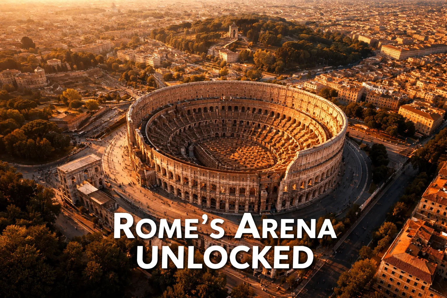
The Colosseum is not oval in the loose sense — it is a mathematically precise ellipse with two focal points. From the ground, you experience curved walls. From directly above at 200+ meters, the four concentric elliptical rings of seating (the ima, media, and summa cavea tiers) resolve into a perfect nested geometry that looks almost computational in its precision. The outermost ring of 80 arched openings, repeated across four stories and 527 meters of circumference, becomes legible as a unified system rather than a series of individual arches. This is colosseum architecture from above at its most revelatory.
The Exposed Hypogeum
The most emotionally powerful aerial image of the Colosseum — and genuinely one of the most striking aerial photographs in architectural history — is the top-down view into the arena floor. The wooden floor that once covered the arena is long gone, and what it exposes is the hypogeum: two stories of underground corridors, cells, and mechanical shaft systems where gladiators, animals, stagehands, and prisoners waited before being hoisted up into the arena via elevators. From directly above, the hypogeum reads like a circuit board — a grid of stone passages bisected by the main axial corridors, surrounded by the curved outer walls. It is a cross-section of Roman engineering that no ground-level visit can fully convey.
The Colosseum’s Urban Relationships
From altitude, the Colosseum stops being an isolated monument and becomes the anchor of a coherent ancient urban system. The Roman Forum stretches to the northwest, its column stumps and triumphal arches forming a processional axis. The Arch of Constantine sits immediately adjacent to the southeast, positioned with obvious intentionality at the terminus of the Via Sacra. Palatine Hill rises to the south, its terraced imperial palaces visible as layered earthworks. Rome landmarks from above drone perspective makes the spatial logic of ancient Rome suddenly, startlingly legible in a way that walking the site never quite achieves.
The Best Shots to Capture: Compositions, Altitudes, and Angles
For the professional aerial photographer who has secured proper authorization, here are the specific compositions that define exceptional Roman Colosseum drone photography.
- The Pure Nadir (Straight Down, 250–300m): Position directly above the center of the arena and shoot straight down at 90 degrees. At this altitude, the complete elliptical ring system fits within the frame and the hypogeum cross-section is fully visible. This is the definitive architectural shot. Early morning light (before 8 AM) keeps shadows from obscuring the underground passages.
- The 45-Degree Northwest Oblique (180–220m): Approaching from the northwest at a 45-degree gimbal angle captures the Colosseum with the Roman Forum receding into the background and Palatine Hill on the right edge. This is the shot that contextualizes the monument within its ancient urban environment and is the most commonly seen in broadcast documentaries.
- The Damaged Southern Arc (100–130m): The southern outer wall was stripped of its stone during the medieval period, leaving the internal seating structure exposed. From a low oblique angle on the south side, this creates a dramatic cross-sectional view showing all four seating tiers simultaneously — like cutting through an orange and looking at the segments. This shot requires lower altitude authorization and precise positioning.
- The Arch of Constantine Relationship (150m, Southeast Position): From the southeast at medium altitude, you can compose a frame that includes both the full ellipse of the Colosseum and the Arch of Constantine in the lower foreground. The spatial relationship between these two structures — deliberately designed by the Romans to be experienced in sequence — becomes architecturally obvious from the air.
Legal Alternatives: Elevated Viewpoints Around Rome That Require No Permits
Here’s what I tell every photographer who asks me about shooting the Colosseum aerially: the hills of Rome are your best friend, and they’re completely free. Palatine Hill, which rises directly adjacent to the Colosseum and is accessible via combined ticket with the Forum and Colosseum, offers elevated ground-level perspectives from the southwest that give you genuine height above the arena floor. The Aventine Hill — accessible via the famous Giardino degli Aranci (Orange Garden) — provides a more distant panoramic view of the Colosseum in its southeastern context. Neither replaces true aerial photography, but both offer perspectives that go far beyond what street level provides. For telephoto ground-based work, a position on the Via Sacra inside the Forum at dawn, when tourist crowds haven’t yet gathered, gives you remarkable long-lens compositions through the Arch of Titus with the Colosseum behind.
If you’re building out Italy travel content and want to pair this with other remarkable aerial destinations where drone rules are more accessible, our guide to Italian aerial photography locations covers sites across the country where recreational drone flight is legally achievable with proper registration and insurance.
Gear Worth Packing: Aerial Photography Equipment for Rome
Even if you’re visiting Rome as a traveler rather than a permitted professional operator, having the right compact aerial kit matters for other destinations on your Italian itinerary — and for understanding what makes great drone imagery before you commission or license authorized footage. Here’s what I recommend and why.
The Mini Drone with 4K Camera and Six-Axis Stabilization Mini Shuttle Foldable FPV Drone is the compact kit I reach for when I need discretion and portability without sacrificing image quality. Its small body and foldable frame slip into a jacket pocket or the front compartment of a camera bag, which matters enormously when you’re moving through crowded European cities between shooting locations. The six-axis gyroscopic stabilization is the real story here ��� on a historical itinerary where you’re shooting at sites with wind exposure (Rome’s hilltop locations and open archaeological zones can gust unpredictably), that stabilization prevents the micro-jitter that ruins otherwise perfect architectural frames. I’ve used small foldable drones like this at permitted sites across the Mediterranean and the footage consistently outperforms what you’d expect from its footprint. The one-key takeoff and headless mode make setup fast when you have a narrow shooting window around the golden hour — you don’t want to spend eight minutes fussing with settings when the light is perfect for exactly eleven minutes.
For travelers who are just beginning to add aerial photography to their travel toolkit, the Drone with Camera with Screen on Controller solves a problem that catches beginners off guard every time: the live feed disconnect. When you’re trying to compose a shot of an architectural subject — even from a legal distance or at an accessible site — losing track of your frame because you’re squinting at a phone screen in Italian sunshine is genuinely frustrating. This drone’s built-in controller screen eliminates that problem entirely, giving you a stable, readable live view even in bright outdoor conditions. The gesture control feature is surprisingly useful for solo travel photography when you want to capture yourself at a viewpoint with the cityscape behind you — no assistant required. I learned to appreciate emergency stop functions the hard way on a shoot near a coastal heritage site in Italy where an unexpected gust pushed the drone toward a restricted zone; having that function mapped to a single button is not a gimmick, it is genuine peace of mind.
The X-shop 1080P Drone with Camera for Adults and Beginners earns its place in this list for one specific, underappreciated reason: the 30-minute flight time across two rechargeable batteries. When you’re photographing at accessible Italian sites — coastal Cinque Terre, the Tuscan countryside, the temples of Sicily — having 30 minutes of actual flight time rather than the 10–12 minutes you get from budget entry-level drones changes what’s achievable in a single session. Architectural aerial photography requires patience; you orbit a subject multiple times at different altitudes testing compositions before you commit to your hero shots, and short battery life truncates that creative process. The altitude hold and 360-degree flip capabilities make it accessible to non-experts, but the image quality and flight endurance make it genuinely useful for travel content creation at legal locations. If you’re building your aerial photography skills before attempting more complex permitted work in heavily regulated zones like Rome, this is an excellent platform to develop your compositional eye.
Frequently Asked Questions
Is drone photography allowed at the Roman Colosseum?
No. Recreational drone flight over the Roman Colosseum and the entire historic center of Rome is prohibited under ENAC (Italy’s Civil Aviation Authority) no-fly zone designations. The area is classified as restricted airspace due to its status as a UNESCO World Heritage Site and a sensitive cultural heritage zone. Professional drone operators can apply for authorization through ENAC, the Italian Ministry of Culture, and the Rome Film Commission, but the permitting process is lengthy and approval is not guaranteed. Tourists who fly drones over the Colosseum risk significant fines and equipment confiscation.
What is the best altitude for photographing the Colosseum from above?
For authorized professional operators, the most effective altitude for capturing the Colosseum’s complete elliptical geometry is between 250 and 300 meters, where both the full outer ring and the exposed hypogeum floor are visible in a single top-down frame. For oblique contextual shots showing the Colosseum in relationship to the Roman Forum and Palatine Hill, 180–220 meters at a 45-degree gimbal angle is optimal. Detailed architectural shots focusing on the exposed seating tiers and the damaged southern wall are most effective at 100–130 meters. All of these altitudes require professional authorization — they are not accessible to recreational operators at this location.
What does the Colosseum look like from directly above?
From directly above, the Colosseum reveals its true geometric identity as a mathematically precise ellipse measuring 188 meters by 156 meters. The four concentric rings of seating resolve into nested ellipses, and the 80 arched openings of the outer wall become readable as a unified structural system rather than individual elements. Most dramatically, the missing arena floor exposes the hypogeum — the labyrinthine underground staging system of corridors, cells, and elevator shafts used to bring gladiators and animals into the arena. From a nadir (straight-down) perspective, the hypogeum looks like an architectural cross-section or a two-thousand-year-old circuit board. This is widely considered one of the most powerful aerial architectural images in the world.
Are there any legal elevated viewpoints for photographing the Colosseum without a drone permit?
Yes. Palatine Hill, accessible via combined ticket with the Roman Forum and Colosseum, provides the most accessible elevated perspective southwest of the arena. The Aventine Hill and its Giardino degli Aranci (Orange Garden) offer a more distant panoramic view from the south. Neither location provides true aerial perspective, but both offer meaningfully elevated ground-based viewpoints that go well beyond street level. For telephoto architectural work, positions within the Roman Forum along the Via Sacra — particularly near the Arch of Titus — allow long-lens compositions that compress the Colosseum against the Forum ruins in visually compelling ways.
How do professional photographers obtain permission to fly drones over the Colosseum?
Professional authorization for drone flying over the Colosseum requires a multi-agency process. Operators must first hold ENAC certification as a professional UAS (Unmanned Aircraft System) operator under Italian drone regulations. They then file for specific airspace authorization through ENAC’s U-Space management system, obtain cultural heritage permissions from the Ministero della Cultura (MiC), and typically coordinate the operational logistics through the Rome
This post contains affiliate links. As an Amazon Associate, I earn from qualifying purchases at no extra cost to you.
Roman Colosseum Drone Photography: Seeing the Eternal City’s Greatest Wonder From Above
The moment the drone climbs past 80 meters and the Colosseum’s full elliptical outline snaps into frame, something shifts in your understanding of what the Romans actually built. From the ground, you experience scale — raw, overwhelming scale. From the air, you experience geometry. The perfect ellipse, 188 meters long and 156 meters wide, emerges from the ancient urban fabric of Rome like a stone fingerprint pressed into the earth two thousand years ago. Roman Colosseum drone photography is, without exaggeration, some of the most visually arresting aerial work you can do anywhere in the world — and also some of the most legally complicated. I want to be honest with you about both of those things from the very first paragraph.
In this guide, I’m going to walk you through what authorized aerial photography of the Colosseum actually looks like, what Italy’s ENAC drone regulations mean in practice for the historic center of Rome, and why the few legally captured aerial images of this structure are so rare and so extraordinary. Whether you’re a professional photographer navigating permit systems or an enthusiast planning a Rome trip who wants to understand what you’re actually allowed to do, this post covers the full picture — from 300 meters up and ground level both.
Drone Flight Brief: Roman Colosseum, Rome, Italy
| GPS Coordinates | 41.8902° N, 12.4922° E |
| Recommended Altitude Range | 100–300m for structure overview; 50–80m for architectural detail shots (professional permits only) |
| Best Time of Day | Golden hour (6:00–7:30 AM in summer) — low angle light rakes across the stone arches and creates dramatic shadow relief |
| Best Season | Late March to May; late September to October — lower tourist density, softer light, less heat haze |
| Drone Regulations Summary | BANNED for recreational use. Central Rome is a designated no-fly zone under ENAC (Italy’s Civil Aviation Authority) rules. Professional aerial photography requires authorization from ENAC, the Italian Ministry of Cultural Heritage (MiC), and coordination with the Rome Film Commission. Violations carry significant fines. |
| Skill Level Required | Advanced (permit-holding professionals only for legal flight over the site) |
| Legal Alternatives | Elevated viewpoints from Palatine Hill, Aventine Hill, and the terrace of the Roman Forum — all permit-free and worth every minute |
Can You Fly a Drone Over the Colosseum? The Honest Answer
Let me be completely direct: if you’re visiting Rome as a tourist with a recreational drone in your bag, flying over the Colosseum is illegal. Full stop. The entire historic center of Rome — including the Colosseum, the Roman Forum, Palatine Hill, and the surrounding archaeological zones — falls within a restricted airspace zone enforced by ENAC, Italy’s national civil aviation authority. This isn’t a gray area or a loosely enforced guideline. It is a hard no-fly designation covering one of the world’s most protected urban heritage sites.
For professional operators, the process of obtaining legal authorization is genuinely complex. You need to file with ENAC under Italy’s U-Space airspace management framework, obtain cultural heritage permission from the Ministero della Cultura (MiC), and in most cases work through the Rome Film Commission, which coordinates professional film and photography operations in and around the archaeological zone. The permitting timeline typically runs 4–8 weeks minimum. This is why drone footage of the Colosseum you see in major documentaries and network broadcast segments is so visually distinctive — it represents a genuine logistical achievement, not just a technical one. The rarity of legally authorized colosseum aerial view rome footage is itself a story worth understanding.
If you’re caught flying recreationally over this zone, fines under Italian aviation law can reach several thousand euros, and your equipment may be confiscated. Italian authorities actively monitor the airspace around major monuments. Do not risk it. The good news is that there are legitimate elevated viewpoints that give you remarkable perspectives on the Colosseum — and I’ll cover those in detail below.
What the Colosseum Aerial View Reveals That You Can Never See From the Ground
Understanding what drone flying over colosseum imagery actually shows is worth your time even if you’ll never hold a professional permit — because it fundamentally changes how you think about this building when you visit in person. Here’s what becomes visible from altitude that is simply invisible from street level.
The True Elliptical Form
The Colosseum is not oval in the loose sense — it is a mathematically precise ellipse with two focal points. From the ground, you experience curved walls. From directly above at 200+ meters, the four concentric elliptical rings of seating (the ima, media, and summa cavea tiers) resolve into a perfect nested geometry that looks almost computational in its precision. The outermost ring of 80 arched openings, repeated across four stories and 527 meters of circumference, becomes legible as a unified system rather than a series of individual arches. This is colosseum architecture from above at its most revelatory.
The Exposed Hypogeum
The most emotionally powerful aerial image of the Colosseum — and genuinely one of the most striking aerial photographs in architectural history — is the top-down view into the arena floor. The wooden floor that once covered the arena is long gone, and what it exposes is the hypogeum: two stories of underground corridors, cells, and mechanical shaft systems where gladiators, animals, stagehands, and prisoners waited before being hoisted up into the arena via elevators. From directly above, the hypogeum reads like a circuit board — a grid of stone passages bisected by the main axial corridors, surrounded by the curved outer walls. It is a cross-section of Roman engineering that no ground-level visit can fully convey.
The Colosseum’s Urban Relationships
From altitude, the Colosseum stops being an isolated monument and becomes the anchor of a coherent ancient urban system. The Roman Forum stretches to the northwest, its column stumps and triumphal arches forming a processional axis. The Arch of Constantine sits immediately adjacent to the southeast, positioned with obvious intentionality at the terminus of the Via Sacra. Palatine Hill rises to the south, its terraced imperial palaces visible as layered earthworks. Rome landmarks from above drone perspective makes the spatial logic of ancient Rome suddenly, startlingly legible in a way that walking the site never quite achieves.
The Best Shots to Capture: Compositions, Altitudes, and Angles
For the professional aerial photographer who has secured proper authorization, here are the specific compositions that define exceptional Roman Colosseum drone photography.
- The Pure Nadir (Straight Down, 250–300m): Position directly above the center of the arena and shoot straight down at 90 degrees. At this altitude, the complete elliptical ring system fits within the frame and the hypogeum cross-section is fully visible. This is the definitive architectural shot. Early morning light (before 8 AM) keeps shadows from obscuring the underground passages.
- The 45-Degree Northwest Oblique (180–220m): Approaching from the northwest at a 45-degree gimbal angle captures the Colosseum with the Roman Forum receding into the background and Palatine Hill on the right edge. This is the shot that contextualizes the monument within its ancient urban environment and is the most commonly seen in broadcast documentaries.
- The Damaged Southern Arc (100–130m): The southern outer wall was stripped of its stone during the medieval period, leaving the internal seating structure exposed. From a low oblique angle on the south side, this creates a dramatic cross-sectional view showing all four seating tiers simultaneously — like cutting through an orange and looking at the segments. This shot requires lower altitude authorization and precise positioning.
- The Arch of Constantine Relationship (150m, Southeast Position): From the southeast at medium altitude, you can compose a frame that includes both the full ellipse of the Colosseum and the Arch of Constantine in the lower foreground. The spatial relationship between these two structures — deliberately designed by the Romans to be experienced in sequence — becomes architecturally obvious from the air.
Legal Alternatives: Elevated Viewpoints Around Rome That Require No Permits
Here’s what I tell every photographer who asks me about shooting the Colosseum aerially: the hills of Rome are your best friend, and they’re completely free. Palatine Hill, which rises directly adjacent to the Colosseum and is accessible via combined ticket with the Forum and Colosseum, offers elevated ground-level perspectives from the southwest that give you genuine height above the arena floor. The Aventine Hill — accessible via the famous Giardino degli Aranci (Orange Garden) — provides a more distant panoramic view of the Colosseum in its southeastern context. Neither replaces true aerial photography, but both offer perspectives that go far beyond what street level provides. For telephoto ground-based work, a position on the Via Sacra inside the Forum at dawn, when tourist crowds haven’t yet gathered, gives you remarkable long-lens compositions through the Arch of Titus with the Colosseum behind.
If you’re building out Italy travel content and want to pair this with other remarkable aerial destinations where drone rules are more accessible, our guide to Italian aerial photography locations covers sites across the country where recreational drone flight is legally achievable with proper registration and insurance.
Gear Worth Packing: Aerial Photography Equipment for Rome
Even if you’re visiting Rome as a traveler rather than a permitted professional operator, having the right compact aerial kit matters for other destinations on your Italian itinerary — and for understanding what makes great drone imagery before you commission or license authorized footage. Here’s what I recommend and why.
The Mini Drone with 4K Camera and Six-Axis Stabilization Mini Shuttle Foldable FPV Drone is the compact kit I reach for when I need discretion and portability without sacrificing image quality. Its small body and foldable frame slip into a jacket pocket or the front compartment of a camera bag, which matters enormously when you’re moving through crowded European cities between shooting locations. The six-axis gyroscopic stabilization is the real story here ��� on a historical itinerary where you’re shooting at sites with wind exposure (Rome’s hilltop locations and open archaeological zones can gust unpredictably), that stabilization prevents the micro-jitter that ruins otherwise perfect architectural frames. I’ve used small foldable drones like this at permitted sites across the Mediterranean and the footage consistently outperforms what you’d expect from its footprint. The one-key takeoff and headless mode make setup fast when you have a narrow shooting window around the golden hour — you don’t want to spend eight minutes fussing with settings when the light is perfect for exactly eleven minutes.
For travelers who are just beginning to add aerial photography to their travel toolkit, the Drone with Camera with Screen on Controller solves a problem that catches beginners off guard every time: the live feed disconnect. When you’re trying to compose a shot of an architectural subject — even from a legal distance or at an accessible site — losing track of your frame because you’re squinting at a phone screen in Italian sunshine is genuinely frustrating. This drone’s built-in controller screen eliminates that problem entirely, giving you a stable, readable live view even in bright outdoor conditions. The gesture control feature is surprisingly useful for solo travel photography when you want to capture yourself at a viewpoint with the cityscape behind you — no assistant required. I learned to appreciate emergency stop functions the hard way on a shoot near a coastal heritage site in Italy where an unexpected gust pushed the drone toward a restricted zone; having that function mapped to a single button is not a gimmick, it is genuine peace of mind.
The X-shop 1080P Drone with Camera for Adults and Beginners earns its place in this list for one specific, underappreciated reason: the 30-minute flight time across two rechargeable batteries. When you’re photographing at accessible Italian sites — coastal Cinque Terre, the Tuscan countryside, the temples of Sicily — having 30 minutes of actual flight time rather than the 10–12 minutes you get from budget entry-level drones changes what’s achievable in a single session. Architectural aerial photography requires patience; you orbit a subject multiple times at different altitudes testing compositions before you commit to your hero shots, and short battery life truncates that creative process. The altitude hold and 360-degree flip capabilities make it accessible to non-experts, but the image quality and flight endurance make it genuinely useful for travel content creation at legal locations. If you’re building your aerial photography skills before attempting more complex permitted work in heavily regulated zones like Rome, this is an excellent platform to develop your compositional eye.
Frequently Asked Questions
Is drone photography allowed at the Roman Colosseum?
No. Recreational drone flight over the Roman Colosseum and the entire historic center of Rome is prohibited under ENAC (Italy’s Civil Aviation Authority) no-fly zone designations. The area is classified as restricted airspace due to its status as a UNESCO World Heritage Site and a sensitive cultural heritage zone. Professional drone operators can apply for authorization through ENAC, the Italian Ministry of Culture, and the Rome Film Commission, but the permitting process is lengthy and approval is not guaranteed. Tourists who fly drones over the Colosseum risk significant fines and equipment confiscation.
What is the best altitude for photographing the Colosseum from above?
For authorized professional operators, the most effective altitude for capturing the Colosseum’s complete elliptical geometry is between 250 and 300 meters, where both the full outer ring and the exposed hypogeum floor are visible in a single top-down frame. For oblique contextual shots showing the Colosseum in relationship to the Roman Forum and Palatine Hill, 180–220 meters at a 45-degree gimbal angle is optimal. Detailed architectural shots focusing on the exposed seating tiers and the damaged southern wall are most effective at 100–130 meters. All of these altitudes require professional authorization — they are not accessible to recreational operators at this location.
What does the Colosseum look like from directly above?
From directly above, the Colosseum reveals its true geometric identity as a mathematically precise ellipse measuring 188 meters by 156 meters. The four concentric rings of seating resolve into nested ellipses, and the 80 arched openings of the outer wall become readable as a unified structural system rather than individual elements. Most dramatically, the missing arena floor exposes the hypogeum — the labyrinthine underground staging system of corridors, cells, and elevator shafts used to bring gladiators and animals into the arena. From a nadir (straight-down) perspective, the hypogeum looks like an architectural cross-section or a two-thousand-year-old circuit board. This is widely considered one of the most powerful aerial architectural images in the world.
Are there any legal elevated viewpoints for photographing the Colosseum without a drone permit?
Yes. Palatine Hill, accessible via combined ticket with the Roman Forum and Colosseum, provides the most accessible elevated perspective southwest of the arena. The Aventine Hill and its Giardino degli Aranci (Orange Garden) offer a more distant panoramic view from the south. Neither location provides true aerial perspective, but both offer meaningfully elevated ground-based viewpoints that go well beyond street level. For telephoto architectural work, positions within the Roman Forum along the Via Sacra — particularly near the Arch of Titus — allow long-lens compositions that compress the Colosseum against the Forum ruins in visually compelling ways.
How do professional photographers obtain permission to fly drones over the Colosseum?
Professional authorization for drone flying over the Colosseum requires a multi-agency process. Operators must first hold ENAC certification as a professional UAS (Unmanned Aircraft System) operator under Italian drone regulations. They then file for specific airspace authorization through ENAC’s U-Space management system, obtain cultural heritage permissions from the Ministero della Cultura (MiC), and typically coordinate the operational logistics through the Rome