
This post contains affiliate links. As an Amazon Associate, I earn from qualifying purchases at no extra cost to you.
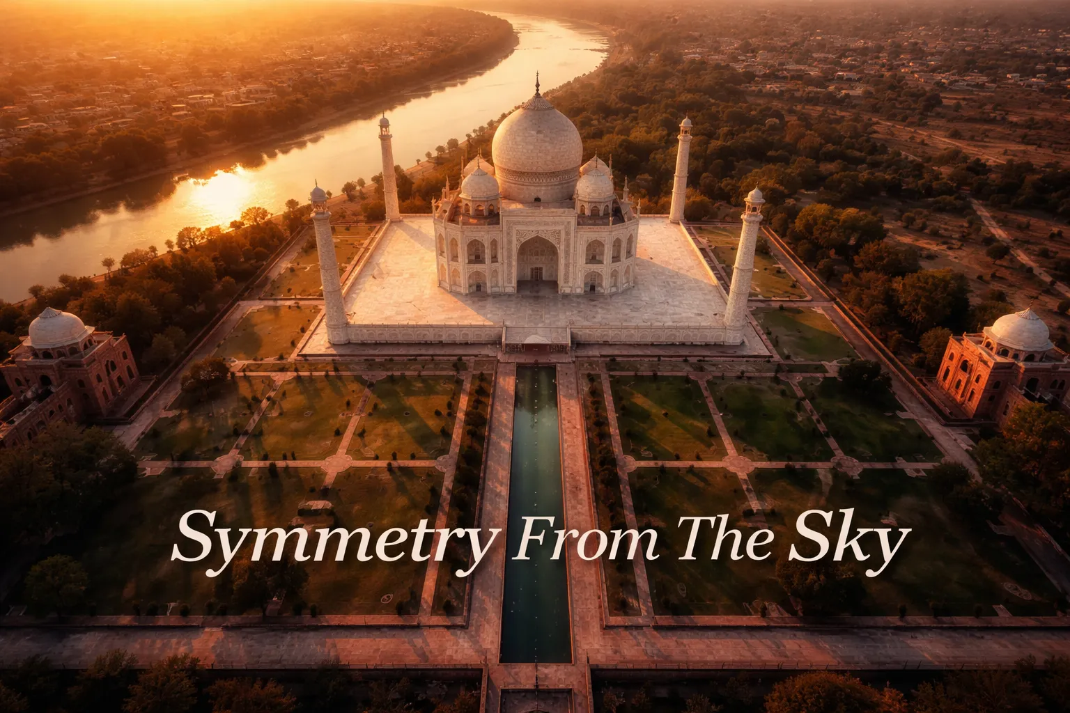
There is a moment — and I will never forget it — when you pull up satellite imagery of the Taj Mahal for the first time and genuinely stop breathing. From altitude, this is not merely a beautiful building. It is a geometric argument, a philosophical statement carved in white marble and laid out across a floodplain in Agra with the kind of mathematical precision that makes you wonder whether Shah Jahan had a drone and just never told anyone. Taj Mahal drone photography aerial content dominates travel photography discussions for exactly this reason: the monument was architecturally engineered to be symmetrical from every conceivable angle, including directly above. The four minarets, the central dome, the long reflecting pool, and the charbagh garden’s four-quarter layout create something that looks, from the sky, less like a building and more like a living mandala. I’ve spent years studying aerial imagery of the world’s great monuments, and nothing quite prepares you for how deliberate this one looks from altitude.
Drone Flight Brief: Taj Mahal Aerial Photography Quick Reference
| GPS Coordinates | 27.1751° N, 78.0421° E (Taj Mahal central dome) |
| Recommended Altitude Range | N/A — drones are strictly prohibited. For context, authorized satellite and media imagery is typically captured at 300–600m+ above ground level. |
| Best Time of Day | Dawn (pink marble effect) or 45 minutes before sunset (golden tone). Full moon nights produce a silvery-white illumination. |
| Best Season | October through March — clear skies, low haze, cooler temperatures. Avoid June–August (monsoon reduces visibility dramatically). |
| Drone Regulations Summary | STRICTLY PROHIBITED. The Archaeological Survey of India (ASI) bans all drone flights over the Taj Mahal and surrounding Agra monuments. Flying without authorization carries criminal penalties under India’s Unmanned Aircraft System Rules 2021. Do not attempt. |
| Skill Level Required | N/A (prohibited) — Legal riverside alternatives require intermediate-to-advanced skill due to wind off the Yamuna River and populated surroundings. |
| Legal Aerial Alternatives | Yamuna River bank viewpoints (north side), authorized media/government aerial surveys, and publicly available high-resolution satellite imagery. |
Can You Fly a Drone Over the Taj Mahal?
Let me be completely unambiguous here, because I’ve seen too many travel blogs dance around this: drone flying over Taj Mahal India is illegal, full stop. The Archaeological Survey of India has placed a blanket prohibition on unmanned aerial vehicles over all ASI-protected monuments, and the Taj Mahal sits at the very top of that list. India’s Unmanned Aircraft System (UAS) Rules 2021 further classify the Taj Mahal precinct as a Red Zone, meaning no drone operations of any kind are permitted without specific central government authorization — authorization that is essentially never granted to individual photographers or tourists.
The practical consequences are serious. Local police and ASI security personnel actively monitor the monument grounds and the surrounding airspace. Anyone found operating a drone in or near the Taj Mahal complex faces equipment confiscation, significant fines, and potential criminal charges. I have spoken with photographers who attempted to fly from the Yamuna River bank directly north of the complex and were stopped by authorities before they could get airborne. The no-fly zone extends well beyond the monument walls themselves. This is not a situation where you can ask forgiveness rather than permission.
What does exist, and what makes this guide genuinely valuable, is a rich archive of authorized aerial imagery — high-altitude satellite photography, officially sanctioned media flyovers, and government survey imagery — that reveals the Taj’s geometry from above in extraordinary detail. Understanding what that imagery shows, and how to find and work with it, is the real aerial photography story here.
What the Taj Mahal From Above Drone View Actually Reveals
The ground-level experience of the Taj Mahal is overwhelming — the scale, the marble, the crowds, the heat. But it hides the monument’s most astonishing secret. From altitude, the Taj Mahal from above drone view and satellite imagery reveals something no guidebook adequately prepares you for: this entire complex was designed as a cosmological diagram.
The charbagh — the four-quarter formal garden that stretches from the main gateway to the mausoleum’s plinth — is divided by two main water channels that intersect at a central fountain pool. From above, these channels align with the cardinal directions, and the geometry is so precise that it reads as intentional celestial mapping. The garden’s quadrants are each further subdivided, creating a 4×4 grid of planting beds that becomes visible only from altitude. This is Islamic paradise garden design at its most mathematically sophisticated, and you simply cannot appreciate its full structure from the ground.
The main mausoleum structure sits on a 95-meter square plinth — a detail that becomes viscerally apparent from above, where the perfect square base contrasts strikingly with the circular dome rising from its center. Here is something that genuinely surprised me when I first studied high-altitude imagery closely: the four minarets are not perfectly vertical. Each minaret leans very slightly outward from the central structure — by approximately 2.7 degrees — a deliberate engineering decision made so that if an earthquake caused them to fall, they would collapse away from the main tomb rather than onto it. From directly above, this outward lean creates a subtle but unmistakable star-burst effect around the central dome, as if the minarets are being gently repelled by the structure at the center.
Perhaps the most remarkable aerial revelation lies across the Yamuna River. On the northern bank, directly opposite the Taj Mahal, satellite imagery shows the foundations and excavated footprint of what historians call the “Black Taj Mahal” — a mirror-image mausoleum that Shah Jahan reportedly planned to build for himself in black marble, connected to the white Taj by a bridge. The project was never completed (Shah Jahan was imprisoned by his son Aurangzeb before construction could begin), but the foundation platform is clearly visible from altitude, suggesting the full vision was meant to be a dual monument reflected across the river — the white tomb of Mumtaz and the black tomb of Shah Jahan, symmetrical across the water itself.
Taj Mahal Symmetry Aerial Photography: The Geometry Worth Understanding
The Taj Mahal’s famous symmetry aerial photography appeal comes from a design principle called bilateral symmetry — the complex is a perfect mirror image of itself along both its north-south and east-west axes. But from altitude, what becomes apparent is that this symmetry operates at multiple scales simultaneously. The individual arabesque inlay patterns on the marble walls mirror each other. The garden beds mirror across both axes. The gateway building mirrors the mausoleum. The two flanking mosque and guesthouse buildings on either side of the main tomb are identical to each other. It creates a fractal-like quality where the symmetry repeats at every level of zoom — which is precisely why aerial photography of the Taj Mahal is so visually compelling even in thumbnail form.
The marble itself changes dramatically depending on light conditions, which matters enormously for aerial photography timing. At dawn, the white marble takes on a deep rose-pink tone as it catches the warm angle of early light — a phenomenon that gave rise to the famous saying that the Taj Mahal “changes color like a mood ring.” By mid-morning, it becomes a cool, almost blinding white. At sunset, the marble turns a burnished amber-gold. Under a full moon, it shifts to a ghostly silver-blue. For aerial photography purposes, dawn and the hour before sunset produce the most dramatic tonal variation and the longest shadows — shadows that, from directly above, trace the outlines of the architectural geometry in dark relief against the glowing marble.
Agra Drone Photography Guide: Legal Alternatives and What You Can Actually Shoot
Despite the prohibition over the Taj itself, an agra drone photography guide is not without legitimate options. The Yamuna River creates a natural buffer zone on the northern side of the complex, and certain riverside locations outside the ASI-restricted boundary have been used by authorized photographers. The key word is authorized — before any drone operation in Agra, you must obtain clearance from the Directorate General of Civil Aviation (DGCA) through India’s Digital Sky Platform, plus separate written permission from the ASI if your planned flight path is within visual range of protected monuments. This is a multi-step process that typically takes weeks and is generally only accessible to professional media organizations, documentary crews, or commercial operators with the right credentials.
What can you photograph without a drone? More than you might expect. The Taj Mahal’s north gate, accessible via a short walk from the main ticket office, opens onto the Yamuna riverbank and provides the famous “Moon Gate” view looking south along the river toward the Taj. This is one of the most extraordinary ground-level compositions in the world, and with a telephoto lens, it is genuinely magnificent. Agra Fort, a 20-minute drive west, offers elevated rampart views looking east toward the Taj across the river — the view Shah Jahan himself used during his imprisonment. These are not aerial views, but they are elevated perspectives that reveal geometry the main entrance approach does not.
For those specifically interested in aerial imagery of the complex, Google Earth Pro offers the most accessible high-resolution satellite imagery, with historical layers that allow you to compare the site across different seasons and years. The ISRO (Indian Space Research Organisation) also periodically releases high-resolution survey imagery of the Taj complex that is genuinely stunning at full resolution.
Gear Worth Packing for Aerial and Ground-Level Photography in Agra
Even if drone operations over the Taj itself are prohibited, the broader principles of aerial and travel photography still apply to any legal drone work you undertake in the region — and equally to the ground-level photography that will be your primary medium here. Filters, in particular, make an enormous difference in the intense Indian light conditions around Agra. The Freewell 3-Pack Magnetic Filters for DJI Neo 2 is a kit I’d pack without hesitation for this kind of assignment. It includes a CPL polarizer for cutting the brutal midday glare off white marble surfaces — glare that will otherwise blow out highlights and flatten all the delicate carved detail — a UV filter for lens protection against fine dust (Agra’s air quality is notoriously challenging), and a Black Glow Mist 1/4 filter that adds a cinematic soft halo effect to specular highlights. In a location where the marble is designed to radiate light, that mist filter turns what would otherwise be a blown-out white blob into something luminous and intentional. The magnetic attachment system means filter changes take seconds rather than minutes — critical when the light is changing fast at dawn.
If you’re flying a DJI Flip or Lito X1 in any legally permissible location during your India travels, the NEEWER ND/PL Filter Set (ND8/PL, ND16/PL, ND32/PL) is the filter kit that will save your footage in India’s extreme light conditions. The combination of neutral density and polarization in a single filter is essential when you’re trying to maintain cinematic shutter speeds (typically double the frame rate) in bright South Asian sun without sacrificing color saturation. I’ve made the mistake of flying without adequate ND filtration in similar high-altitude bright-light environments and ended up with crispy, overexposed footage with no shadow detail whatsoever. The snap-on design makes field swapping genuinely practical, and the multi-coating on these filters handles the haze and atmospheric scatter that plagues aerial footage in the Ganges plain region. Going from ND16/PL to ND32/PL in the middle of a golden-hour shoot as the light intensifies is the kind of capability that separates workable footage from portfolio footage.
For DJI Mini 3 and Mini 3 Pro operators — the most popular drones among traveling photographers for their compact size and accessible weight class — the K&F Concept Circular Polarizer CPL Filter is the single most impactful accessory you can add. The 28-layer multi-coating is not marketing language — I’ve compared single-coated CPL filters against multi-coated versions in bright conditions and the difference in ghosting and flare resistance is visible immediately. In a location surrounded by water — whether the Yamuna River, decorative pools, or the Taj’s long reflecting channel — a CPL filter is the difference between seeing the depth and color beneath a reflective surface versus seeing only a washed-out mirror. The Taj’s long northern reflecting pool, when photographed from an elevated perspective, becomes a second sky without a CPL; with one, it renders as a deep, dimensional element with genuine depth. For travel drone photography broadly, this is the filter I never leave behind.
The Best Aerial Compositions: What Authorized Imagery Teaches Us
Studying authorized aerial and satellite imagery of the Taj Mahal reveals several compositions that stand out as definitively superior for conveying its full architectural meaning. The nadir shot — camera pointing straight down from directly above the central dome — is the most iconic, revealing the perfect octagonal symmetry of the main structure and the four-pointed star geometry of the plinth corners. At an altitude of approximately 400–500 meters, this framing includes the full charbagh garden from gate to mausoleum, making the mandala-like quality of the overall layout unmistakable.
The oblique north-facing shot — taken from above the Yamuna River looking south toward the main facade — is arguably the more beautiful composition, because it places the mausoleum in relation to the river that both defines and reflects it. This angle catches the reflection in the Yamuna at dawn, effectively doubling the monument in the frame. The authorized media footage shot from this angle during sunrise is, in my assessment, the single most spectacular aerial image of any monument in the world. The white marble catches pink dawn light while its reflection ripples gold on the river surface below.
At higher altitudes — 600 meters or above — the broader urban context of Agra becomes part of the story, with the Taj emerging from a dense cityscape in a way that emphasizes its otherworldly scale and isolation within its formal garden boundary. This is the composition that best conveys the political and historical statement Shah Jahan was making: here is perfection, surrounded by the imperfect world, carved from white stone imported from Makrana, 400 kilometers away, as a monument to love that was also unmistakably a monument to imperial power.
Frequently Asked Questions
Is drone photography at the Taj Mahal legal for tourists?
No. The Archaeological Survey of India prohibits all drone operations over the Taj Mahal and the surrounding ASI-protected precinct. Under India’s UAS Rules 2021, the Taj Mahal complex is designated as a Red Zone, meaning no drone flights are permitted without central government authorization. This applies to all tourists and visitors regardless of nationality. Penalties include equipment confiscation, fines, and potential criminal charges. There are no exceptions for small recreational drones or camera equipment under a certain weight.
What does the Taj Mahal look like from directly above?
From directly above, the Taj Mahal reveals extraordinary geometric symmetry that is invisible from ground level. The main mausoleum sits on a perfect 95-meter square plinth with octagonal chamfered corners, creating an eight-pointed star silhouette. The four minarets lean very slightly outward (approximately 2.7 degrees) from the main structure, creating a subtle starburst effect. The surrounding charbagh garden is divided into a precise 4×4 grid of planting beds by water channels aligned with the cardinal directions. The overall composition reads as a mandala — a symmetrical cosmological diagram — which was almost certainly the architectural intention. High-resolution satellite imagery from Google Earth provides accessible views of this geometry.
Are there legal ways to get aerial photographs of the Taj Mahal?
Yes, several legal alternatives exist. High-resolution satellite imagery from platforms like Google Earth Pro provides detailed aerial views of the complete complex at no cost. Commercial satellite imagery providers offer even higher resolution imagery for licensed use. Documentary and media organizations occasionally obtain official government authorization for aerial photography, and this footage is sometimes commercially licensable. From a ground-level perspective, the northern riverbank (Moon Gate viewpoint) and the elevated ramparts of Agra Fort both provide legally accessible elevated perspectives that capture aspects of the Taj’s geometry not visible from the main entrance approach.
What is the best time of day to photograph the Taj Mahal for color effects?
The Taj Mahal’s white Makrana marble changes color dramatically throughout the day, and timing is critical for photography. At dawn — approximately 30 minutes after sunrise — the marble takes on a deep rose-pink tone due to the warm angle of early light combined with the translucent quality of the marble itself. By mid-morning it becomes a brilliant, nearly blinding cool white. In the hour before sunset, it shifts to amber-gold. Under a full moon (access is granted on