
This post contains affiliate links. As an Amazon Associate, I earn from qualifying purchases at no extra cost to you.
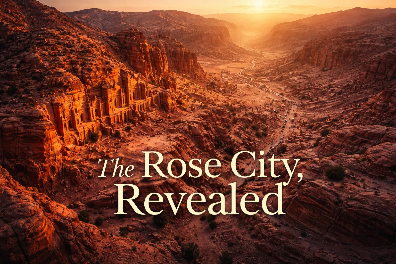
The moment my drone cleared the rim of the canyon and I saw Petra — all of it — laid out below me in shades of rose, amber, and burnt sienna, I understood something that two thousand years of ground-level visitors never could. This isn’t just a Treasury carved into a cliff face. It’s an entire city sculpted from a mountain range. Petra Jordan drone photography doesn’t just change your perspective — it completely rewrites the story of what this place is. From 200 meters above the canyon floor, the Siq looks like a single crack in the earth, and the Treasury’s carved pediment is barely a postage stamp at its end. But the carved facades extend for kilometers in every direction, and suddenly the Rose City earns that name in a way no postcard ever captured.
Petra Jordan Drone Photography: Flight Brief
| GPS Coordinates (Treasury) | 30.3285° N, 35.4444° E |
| GPS Coordinates (Monastery) | 30.3406° N, 35.4320° E |
| Recommended Altitude Range | 150–300m AGL for landscape context; 80–120m for facade detail |
| Best Time of Day | 6:00–8:30 AM (golden hour, low tourist density) and 4:30–6:00 PM (sunset warmth on rose sandstone) |
| Best Season | March–April and October–November (mild temps, dramatic skies, lower visitor numbers) |
| Drone Regulations | Drones are officially restricted inside the Petra Archaeological Park. A permit from the Jordan Civil Aviation Regulatory Commission (CARC) is required. Commercial operators occasionally receive approval; unauthorized flights risk equipment confiscation and fines. |
| Skill Level Required | Advanced — narrow canyon approaches, unpredictable thermal currents, no-fly proximity to UNESCO site |
| Nearest Airport | King Hussein International Airport (AQJ), Aqaba — approx. 120 km south |
What the Petra Aerial View Reveals That Ground Level Cannot
Standing at the end of the Siq and looking at the Treasury, you’re seeing exactly what the Nabataeans wanted you to see — a single, overwhelming facade designed to dominate your field of view. It works brilliantly as theater. But the petra aerial view treasury shot tells a completely different architectural story. From directly above at around 250 meters, you can trace the entire Siq canyon as it snakes for 1.2 kilometers before opening into the Petra basin. The Treasury itself shrinks into context — one facade among dozens carved into the canyon walls — and the geometric logic of the entire city becomes visible for the first time.
The Monastery, known locally as Ad Deir, is the revelation that surprises most aerial photographers. At 47 meters wide and 48 meters tall, it is physically larger than the Treasury, yet because it requires an 800-step climb to reach, most Petra visitors never see it. From the air, the Monastery sits on a high plateau with the Valley of Moses (Wadi Musa) spreading behind it to the west — a composition that is simply impossible from ground level. At sunset, the western light catches the Monastery’s carved urn finial directly while the surrounding plateau falls into shadow, and the result is one of the most dramatic aerial compositions in the entire Middle East.
The Royal Tombs, a row of five elaborately carved facades along the eastern cliff face, only make complete architectural sense from above. Ground-level visitors see each tomb individually. From 150 meters, you can see how they were planned as a unified memorial complex, with the Urn Tomb’s courtyard terrace visible as a deliberate civic space carved from the cliff. The Colonnaded Street — Petra’s main Roman-era thoroughfare — reads from the air as a clear urban spine connecting the city’s ceremonial core, something you can walk for twenty minutes without ever fully grasping at ground level.
And then there’s the color. The rose-red sandstone that gives Petra its nickname shifts in ways that only altitude reveals. From the ground, you see the warm tones of whatever facade is in front of you. From 200 meters, you watch the color temperature of the entire basin change as the sun moves — deep burgundy in early morning shadow, blazing coral at midday, and a soft mauve at dusk that photographers describe as almost otherworldly. The petra from above rose city shot at the right moment isn’t just a photograph; it’s a geological event you’re witnessing in real time.
Can You Fly a Drone at Petra? Regulations and the Reality on the Ground
Let me be completely honest here, because I’ve seen too many travel blogs gloss over this: drone flying over petra without authorization is illegal and the enforcement is real. The Petra Archaeological Park is a UNESCO World Heritage Site under the jurisdiction of the Petra Development and Tourism Region Authority (PDTRA), and Jordan’s Civil Aviation Regulatory Commission (CARC) classifies it as a restricted airspace zone. Rangers are present throughout the site, and confiscation of equipment is the standard response to unauthorized flights. I have spoken with operators who lost drones this way. Do not risk it.
The permit pathway exists, but it is not straightforward for independent travelers. Commercial film and photography productions can apply through CARC and the Jordan Tourism Board, typically with a minimum lead time of four to six weeks and a requirement to demonstrate professional credentials, insurance, and a specific shooting plan. The Jordan Film Commission (film.jo) is the most useful starting point for serious operators — they have facilitated permitted aerial shoots over Petra for documentary and commercial clients. Fees vary significantly by project scope.
The practical reality for independent travel photographers is this: the extraordinary aerial images of Petra you’ve seen were captured either by permitted commercial operators or by photographers who flew from the surrounding ridgelines outside the park boundary — a legal gray area that requires careful GPS verification of park boundaries. The high plateau above the Monastery and the ridges overlooking Wadi Rum to the south offer legitimate elevated positions for aerial photography without crossing into restricted airspace. Speaking of Wadi Rum — if you’re building a Jordan itinerary, the wadi rum petra drone guide pairing is worth planning carefully, because Wadi Rum has a comparatively more accessible permit structure and the sandstone landscape is equally dramatic from the air.
The Best Shots to Capture: Compositions, Altitudes, and Timing
The Treasury Canyon Approach Shot
The definitive Petra aerial composition positions the drone directly above the Siq at approximately 220–280 meters, looking straight down the canyon axis toward the Treasury facade. The best execution of this shot requires early morning light — specifically the window between 7:00 and 8:00 AM in spring and fall — when the sun is low enough to cast directional shadow into the Siq while still illuminating the Treasury’s upper carved registers. The narrow slot canyon creates a natural leading line that ground-level photography can only suggest; from directly above, it becomes the dominant compositional element.
The Monastery at Sunset
Position at 100–150 meters, slightly to the northeast of the Monastery facade, in the final 45 minutes of daylight. At this altitude, the carved urn finial at the top of the facade catches the last direct sunlight while the plateau behind it glows in reflected warm tones. Include the winding trail from the valley floor in the lower portion of the frame — it provides scale and context that makes the structure’s isolation feel genuinely remote. This is the shot that best communicates the Monastery’s overlooked grandeur.
The Royal Tombs in Canyon Context
At 180–200 meters with a slightly oblique northeast-facing angle, you can capture all five Royal Tomb facades in a single frame while also showing the canyon geography that frames them. The optimal window is mid-morning when the east-facing cliff catches direct light. This is the composition that best illustrates the urban planning intelligence of the Nabataean civilization — what looks like isolated monuments from the ground reads as a coherent architectural district from above.
The Colonnaded Street as Urban Spine
At 250–300 meters looking north along the main axis of the valley, the Colonnaded Street becomes legible as the organizing infrastructure of an entire city. Shoot at midday when the stone column stubs cast short shadows and the white marble remnants catch maximum light contrast against the rose canyon walls. This altitude reveals the full extent of the lower city — markets, temples, and civic spaces — that most visitors walk through without ever comprehending as a unified urban whole.
Gear Worth Packing for Petra Jordan Drone Photography
The sandstone canyon environment at Petra presents a specific and underestimated threat to drone equipment: fine particulate dust. The same wind that creates beautiful atmospheric haze in your images will drive grit into motor housings, optical sensors, and propeller mechanisms. I cannot overstate how much the Carbon Fiber Armored Bumper for DJI NEO 2 changed my confidence flying in canyon environments like this. This anti-collision, anti-scratch protective frame fully surrounds the drone’s body, and the carbon fiber construction means you’re adding meaningful protection without the weight penalty that plastic cage systems impose. In a site where an unexpected thermal updraft could push your drone into carved sandstone that is literally irreplaceable, having a full armor system isn’t optional — it’s the cost of responsible operation. I learned this lesson on a shoot in a similarly dusty sandstone environment in Cappadocia, where a light gust pushed my unprotected drone into a cliff face during what I thought was a stable hover. The frame took the hit cleanly; without it, that would have been a very expensive and very embarrassing day.
For lower-altitude work around the narrower sections of canyon — particularly if you’re scouting compositions close to rock faces or practicing near the ridgelines outside the park — propeller protection becomes the priority concern. The BONKZEBU 4pcs Drone Propellers Protectors Blades Guard is a quick-release system that snaps on and off in seconds, making it practical to add protection for low-speed canyon scouting passes and remove it for high-altitude open-sky shots where aerodynamic efficiency matters more. The blade guard design is specifically engineered for safe flying at low speeds and in confined spaces — exactly the operational profile you’ll encounter when composing tight shots along the canyon rim. What I appreciate most about this system is the quick-release mechanism: when conditions suddenly open up and you want to push altitude fast to catch a cloud formation over the basin, you’re not fumbling with screws or clips. Snap off, fly, snap back on for the approach back to the landing zone.
If you’re operating in the dusty southern Jordan environment for more than a day or two — particularly if your itinerary includes both Petra and Wadi Rum, where blowing sand is a near-constant factor — the All Carbon Fiber Armored Mecha for DJI NEO 2 is the most comprehensive protection solution I’ve found for this region. The high-strength carbon fiber construction is explicitly engineered to resist sand and gravel scratches — which matters enormously in an environment where airborne grit is not a hypothetical but a daily operational condition. The ultra-rigidity of the full mecha frame also provides meaningful structural protection during the kind of hard transport that desert itineraries involve: bouncing in a 4WD across Wadi Rum’s sand tracks, stuffed into a day pack on the 800-step Monastery climb, packed into overhead bins on regional flights. I’ve watched drone bodies develop micro-fractures from transport stress alone on multi-week trips; a full rigid frame system eliminates that failure mode entirely and lets you focus on the photography rather than the equipment anxiety.
Planning Your Jordan Aerial Photography Itinerary
Petra sits in the Ma’an Governorate of southern Jordan, approximately 240 kilometers south of Amman and 120 kilometers north of Aqaba. The most logical aerial photography itinerary pairs Petra with Wadi Rum — the vast red desert landscape 60 kilometers to the southeast that offers a comparatively more accessible drone permit environment and equally spectacular sandstone topography. A five to seven day southern Jordan trip built around both locations gives you enough time to work the different light conditions properly, since the color temperature difference between Petra’s enclosed canyon light and Wadi Rum’s open desert light requires meaningfully different exposure strategies.
March through April and October through November are consistently the best months for aerial photography at this latitude. Summer temperatures in the canyon regularly exceed 38°C, which degrades battery performance significantly and creates heat shimmer that softens aerial imagery. Winter brings the possibility of snow on the canyon rims — which creates extraordinary photographic conditions but also unpredictable wind patterns that demand conservative altitude decisions. Spring and fall offer stable thermals in the morning hours, dramatic cloud formations in the afternoon, and the cooperative weather windows that permit planning rather than just reacting.
Stay in Wadi Musa, the town that borders the park entrance — it gives you early morning access before tourist crowds build and the option to return in the late afternoon for golden hour work. The pre-dawn entry window, available at the park entrance from around 6:00 AM in spring, is worth every groggy alarm. The Siq at first light, with mist sometimes sitting in the canyon bottom and the sandstone warming from deep shadow to rose gold in minutes, is one of the most photographically dense half-hours anywhere in the world — whether you’re operating a drone or a handheld camera.
Frequently Asked Questions
Are drones allowed inside Petra Archaeological Park?
No. Drones are officially restricted inside the Petra Archaeological Park, which is protected under Jordanian law as a UNESCO World Heritage Site. Flying without authorization risks equipment confiscation, fines, and removal from the site. Commercial operators and film productions can apply for permits through Jordan’s Civil Aviation Regulatory Commission (CARC) and the Jordan Film Commission, but the process requires professional credentials, insurance documentation, and a minimum of four to six weeks lead time. Independent travelers should not attempt unauthorized flights.
What is the best time of day to photograph Petra from the air?
The best window for aerial photography at Petra is 6:00–8:30 AM during spring and fall months. At this time, the low-angle golden hour light enters the canyon at a directional angle that creates dramatic shadow definition on the carved facades, the rose sandstone reads at maximum color saturation, and tourist density is low enough to keep ground-level movement from cluttering aerial compositions. The secondary window of 4:30–6:00 PM before sunset is particularly effective for the Monastery, which faces west and catches full directional light in the final hour of the day.
What makes the aerial view of Petra different from ground-level photography?
Ground-level photography at Petra captures individual facades — the Treasury from the Siq, the Monastery from its courtyard, the Royal Tombs from the colonnade. Aerial photography reveals the spatial relationships between all these structures simultaneously, making the scale and urban planning of the Nabataean city comprehensible for the first time. From 200–300 meters, you can see the Siq as a single geographic feature, the entire Royal Tombs complex as a unified architectural district, and the Colonnaded Street as the organizing spine of a complete Roman-era city plan. The color shift of the rose sandstone across the entire basin at different times of day is also only visible at altitude.
What drone should I use for Petra and Wadi Rum?
A compact, portable drone with strong wind resistance and excellent camera quality is the priority for southern Jordan. The DJI Mini 4 Pro and DJI Air 3 are both well-suited to the environment — small enough for easy transport on hiking trails to elevated shooting positions, capable enough to handle the moderate wind conditions common in canyon environments. Whatever drone you bring, equip it with comprehensive protective gear appropriate for dusty sandstone environments: a full carbon fiber armor frame, propeller guards for low-altitude canyon work, and carry all batteries in a temperature-controlled bag during the summer months when heat significantly reduces flight time.
Can I combine a Petra drone photography trip with Wadi Rum?
Yes, and this combination is highly recommended for aerial photographers. Wadi Rum sits approximately 60 kilometers southeast of Petra and offers some of the most dramatic desert landscape aerial photography in the world, with its own distinct sandstone topography, towering rock formations, and clean open-sky shooting conditions. Wadi Rum’s permit process, while still requiring advance coordination, has historically been more accessible for small commercial and serious