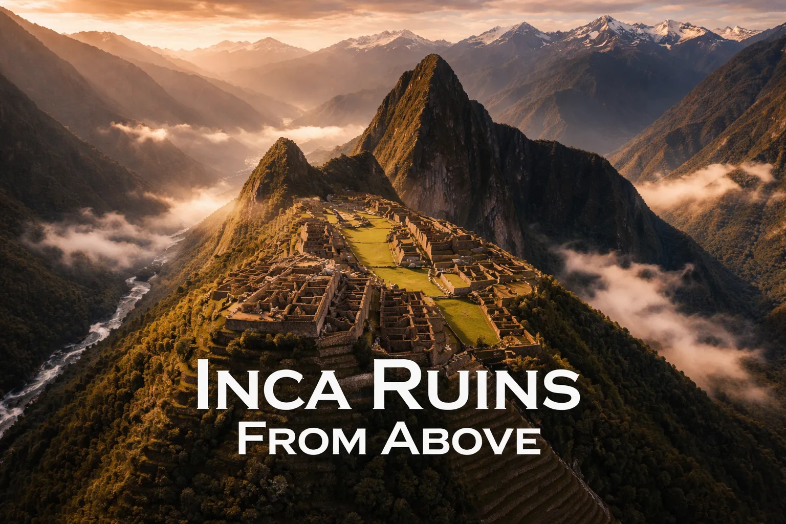
One of my Andean groups had a client who nearly missed the return train to Cusco because he refused to stop flying — not over the ruins themselves, thankfully, but from a ridge above the Urubamba Valley, where his screen filled with that impossible citadel clinging to its saddle between two peaks, terraces spilling toward the jungle, the river tracing a silver arc far below. I still remember the look on his face when I told him it was time to pack up. This Machu Picchu drone photography guide exists so you understand, before you ever land in Peru, what’s legally possible, what the aerial angle actually shows you, and how to work one of the most dramatic backdrops any drone pilot will ever point a camera at. Nothing from my earlier years of aerial work prepared me for how the Andes don’t just frame Machu Picchu — they swallow it, dwarf it, and somehow make it more staggering in the process.
Drone Flight Brief: Machu Picchu Aerial Photography at a Glance
| GPS Coordinates (Citadel Reference) | 13°9′47″S, 72°32′44″W |
| Elevation of Site | 2,430 m (7,972 ft) above sea level |
| Recommended Altitude Range (legal zones) | 50–150 m AGL from surrounding valley launch points |
| Best Time of Day to Fly | 6:00–8:30 AM (pre-valley cloud buildup); golden hour 5:00–5:45 PM |
| Best Season | May–September (dry season); clearest skies in June–July |
| Drone Regulations Summary | Drones are officially banned at Machu Picchu Historic Sanctuary (UNESCO World Heritage Site). Peru’s DGAC requires operator certification and prior authorization for commercial flights. Limited legal flying possible in surrounding valley zones — see regulations section for full detail. |
| Skill Level Required | Advanced — high altitude, unpredictable valley winds, limited safe landing zones |
| Difficulty Rating | ⬛⬛⬛⬛⬜ (4/5) |
Is Drone Flight Permitted at Machu Picchu? The Real Answer
I’ll skip the hedging you’ll find on a lot of travel sites and just say it plainly: flying a drone over Machu Picchu is against the law. Peru’s Ministry of Culture, which oversees the Historic Sanctuary, holds a firm no-drone stance across the entire protected zone. It doesn’t matter whether you’re shooting for a client or just for yourself — the rule covers both. Launch inside the sanctuary boundaries, which stretch well beyond the ruins into the surrounding buffer land, and you’re gambling with confiscated gear, steep fines, and possibly a night in custody. The guards posted at the site have gotten sharper about spotting drones, and tourist police regularly work the trails climbing up from Aguas Calientes.
Layer on top of that: Peru’s Dirección General de Aeronáutica Civil (DGAC) mandates that anyone flying in Peruvian airspace register their aircraft, and anything beyond casual hobby use requires advance flight authorization. That paperwork moves slowly through the bureaucracy and can eat several weeks. Between the UNESCO protections, the national aviation rules, and the visible enforcement on the ground, this is not a spot where sneaking up at first light and dealing with consequences later is a workable strategy — I’ve watched that gamble cost other photographers dearly, and it will cost you too.
Here’s the good news, though: you can absolutely get the aerial angle legally, and in a lot of ways the perspective you gain from the surrounding valley and approach routes ends up more striking than a straight-down shot of the ruins would ever be.
Legal Launch Zones: Getting a Machu Picchu Aerial View Drone Shot the Right Way
The Urubamba Valley — the Sacred Valley of the Incas — has plenty of legitimate spots to launch from that still deliver footage worth the effort. Positioning is everything: fly from the correct patch of valley floor outside the sanctuary line and you’ll still capture the full geographic drama that makes this place special. Below are the launch points that have given me the strongest results.
The Aguas Calientes Approach Zones
Aguas Calientes (its official name is Machupicchu Pueblo) sits down in the valley right beneath the citadel, and certain patches of open ground — especially near the edges of town, away from the train station — fall outside the sanctuary’s immediate boundary. Send a drone up 80–120 m AGL from there and you get a view of Machu Picchu Mountain and Huayna Picchu rising out of the jungle, with the Urubamba River carving its horseshoe bend below — a shot that basically explains why the Inca picked this spot in the first place. This isn’t a top-down look at the ruins; it’s a composition built around the relationship between the ruins and the land around them, and honestly, that’s the more compelling frame.
The Urubamba River’s Wider Story
Push further down the valley toward Ollantaytambo, and both the terrain and the regulations loosen up considerably. Launch near km 88 or km 104 on the rail line — both well-known trekking access points — and you’ll pick up the valley’s winding, serpentine layout with the Andes stacked in the background. These frames set the geographic stage for the whole Inca heartland. A strong Machu Picchu aerial view drone shot doesn’t always need to be tight on stone walls — sometimes the story is about why this civilization built here at all.
What Altitude Uncovers: Viewing the Inca Ruins From the Sky
Even shooting from legal ground beyond the sanctuary, the view from above reveals things about Machu Picchu that no one standing among the walls ever notices. After studying this site from every aerial angle I could legally access — my own footage, authorized documentary material, and satellite imagery — here’s what altitude actually shows you, and why it reshapes how you see the place.
- The Terraces Aren’t Just Farming — They’re Geometry: Seen from up high, the terracing stops looking like agricultural infrastructure and starts reading like a deliberate artistic gesture. The curves and angles trace the mountain’s contours with a precision that goes beyond function, hinting at intentional design. That geometric pattern only becomes visible once you’re roughly 200 m up.
- The City’s Layout Echoes the Mountains Behind It: This is the discovery that genuinely stopped me. Viewed from the northeast at height, the roofline of Machu Picchu’s core structures mirrors the ridgeline of the peaks rising behind the site — a deliberate alignment baked into the original design. You cannot spot this from ground level. Elevation is the only way to see it.
- The Water System Makes Sense From Above: Looked down on, the drainage channels, fountains, and water routing reveal themselves as a single coherent network rather than scattered features. The Inca piped water from a mountain spring through 16 fountains in sequence, engineering that’s still working today. From the air you can trace how the whole settlement was built around that spine of water.
- The Ridge-Top Setting Feels Impossible: Anyone on the ground knows they’re up high. From altitude, though, you actually grasp that the site occupies a narrow saddle between two peaks, with sheer drops of hundreds of meters on more than one side. Seeing that from above makes the engineering feat feel far more absurd than it does when you’re inside the walls themselves.
Standout Drone Shots of Machu Picchu: Angles, Framing, and Altitude Notes
These are the specific compositions I chase whenever I’m working the legal zones around the sanctuary. Treat this as a shot list for the surrounding Urubamba landscape — one that tells the Machu Picchu story without ever crossing into restricted airspace.
The Big Reveal
Begin low, around 20–30 m AGL, with the Urubamba River filling the bottom of the frame, then pull back while climbing gradually to 100–120 m. As you rise, the valley walls drop away and the entire Andean cordillera opens up on every side. This shot answers the question everyone watching will eventually ask: just how enormous is the terrain surrounding this place? The answer is almost too much to take in, and the slow reveal is what sells that scale on screen. Shoot 4K at 24fps for the cinematic look, and bring ND filters to control shutter angle against the harsh Andean light.
Huayna Picchu as a Silhouette
From valley spots with a clean sightline, frame Huayna Picchu’s sharp spire in the left third of your shot while the broader range fills out the right side — it’s one of the most instantly recognizable Andean compositions in aerial work. Aim for 80–100 m AGL, camera tilted roughly 20–30 degrees below the horizon. Shoot during morning golden hour, when the low sun lights up the peak’s eastern face and drops the valley into purple shadow.
The River Bend as Pure Abstraction
From valley-floor launch points at 120–150 m AGL, the Urubamba’s dramatic horseshoe curve turns into a purely graphic element — a silver ribbon cutting through dark jungle, boxed in by vertical valley walls. Point the camera straight down, or steep at 60–70 degrees below horizontal, to strip out the horizon and produce an image that momentarily confuses the eye. It’s one of the best drone shots Machu Picchu context photography has to offer — strong enough to anchor a gallery even with no ruins in the frame at all.
Flying a Drone Over Machu Picchu, Peru: Altitude, Wind, and Gear Stress
Working at 2,430 m above sea level — and higher still in some of the approach areas nearby — throws up technical problems that catch drone photographers used to lower elevations off guard. Thinner air means your propellers produce less lift per spin than they would at sea level. Most consumer drones lose 15–25% of their hover efficiency at Machu Picchu’s altitude, and that translates straight into much faster battery drain. A battery good for 28 minutes at sea level might only last 18–20 minutes here. Build your flight plan with margin: turn back once you hit 40% battery, never later, and always keep a second charged battery on hand.
Wind in the Urubamba Valley is complicated and unpredictable enough to demand real caution. The valley behaves like a funnel, and thermal activity ramps up fast after 9:00 AM once the sun starts heating the walls. By mid-morning, gusts of 25–35 km/h are routine, and by afternoon conditions turn genuinely risky for consumer-grade drones. The 6:00–8:30 AM window isn’t just when the light is best — in most conditions, it’s the only window where flying is actually safe. I’ve watched drones fight to hold position here in ways I never see at lower elevations, and the terrain leaves almost zero room for mistakes.
Keep an eye on motor temperature too. Flying at altitude for extended periods makes motors work harder, and that can push them toward overheating in ways sea-level flying never does. Cap individual flights at 12–15 minutes, let motors cool down between runs, and check your telemetry closely throughout.
Propellers That Held Up Against the Urubamba Wind
Flying here means fighting altitude, thin air, and wind that funnels through the valley without warning. What you need are propellers that won’t snap mid-flight and leave your shot stranded 300 meters above a gorge.
Where they earned their keep
- The red-and-black coding lets you actually tell which prop goes where while rummaging through your pack at 2 a.m. before a sunrise flight — no straining to read tiny labels in the dark.
- With 16 in the set, you’ve got backups for your backups — I cracked one on a gust near the Temple of the Sun and still had four full sets left untouched.
- They stayed reliable across two weeks of Peruvian humidity and altitude stress, with no warping or balance issues showing up.
Where they fell short
- They’re louder than I expected — a real issue if you want ambient sound of the ruins or you’re trying not to draw ranger attention during those legally gray early-morning windows.
- Sixteen pieces is more than most trips need unless you’re staying weeks; shipping all that plastic to Peru felt excessive when I only ended up burning through three sets.
On my second day, a prop started exhibiting slight wobble at full throttle—I genuinely thought I’d have to pack it in—but swapping in a fresh one from my backup set fixed it immediately. If you’re serious about capturing that vista, SoloGood 1045 (10×4.5) Propellers — 16-piece set in Red and Black for F450/F550/S500 quadcopters is worth the peace of mind.
Frequently Asked Questions
Can I legally fly a drone over Machu Picchu ruins?
No. Flying a drone over Machu Picchu is against the law. Peru’s Ministry of Culture holds a firm no-drone stance across the entire Historic Sanctuary protected zone. The rule covers both commercial and personal use, and violations can result in confiscated gear, steep fines, and possibly custody.
Where can I legally fly a drone near Machu Picchu?
You can fly from legal launch zones in the surrounding Urubamba Valley outside the sanctuary boundary. Aguas Calientes has open ground patches away from the train station, and points further down the valley near km 88 or km 104 on the rail line offer legitimate launch spots that still capture aerial views of the site and landscape.
What altitude and time should I fly a drone at Machu Picchu?
Fly between 50–150 m AGL from valley launch points. The best window is 6:00–8:30 AM before cloud buildup, or golden hour from 5:00–5:45 PM. Flying during mid-morning onward is risky; winds reach 25–35 km/h by afternoon due to valley thermals and funnel effects.
What season has the best drone flying weather at Machu Picchu?
Fly during the dry season from May–September, with the clearest skies in June–July. Avoid wet season months when cloud buildup and valley conditions make legal aerial work difficult and less visually compelling.
About This Article

Written by Elena Vasquez. Elena Vasquez is a full-time traveler and the founder of Witty Passport. Over fifteen years and more than 50 countries across six continents — including a stretch spent leading groups professionally through Southeast Asia and the remote highlands of South America — she's written the kind of destination guides she always wished existed: practical, specific, and built on real experience rather than recycled itineraries. More about this site.
Scope and limits. Elena is a full-time traveler, not a licensed travel agent or immigration adviser. Entry requirements, visa rules, and advisories change without notice — always confirm against the official government source for your destination and passport before booking.
Verify this against a primary source
Specifics change, and your situation may differ from the one described here. These are the authorities worth checking directly:
- U.S. Department of State — entry requirements and travel advisories
- CDC Travelers' Health — vaccination and health notices by destination
- TSA — current carry-on and screening rules