
This post contains affiliate links. As an Amazon Associate, I earn from qualifying purchases at no extra cost to you.
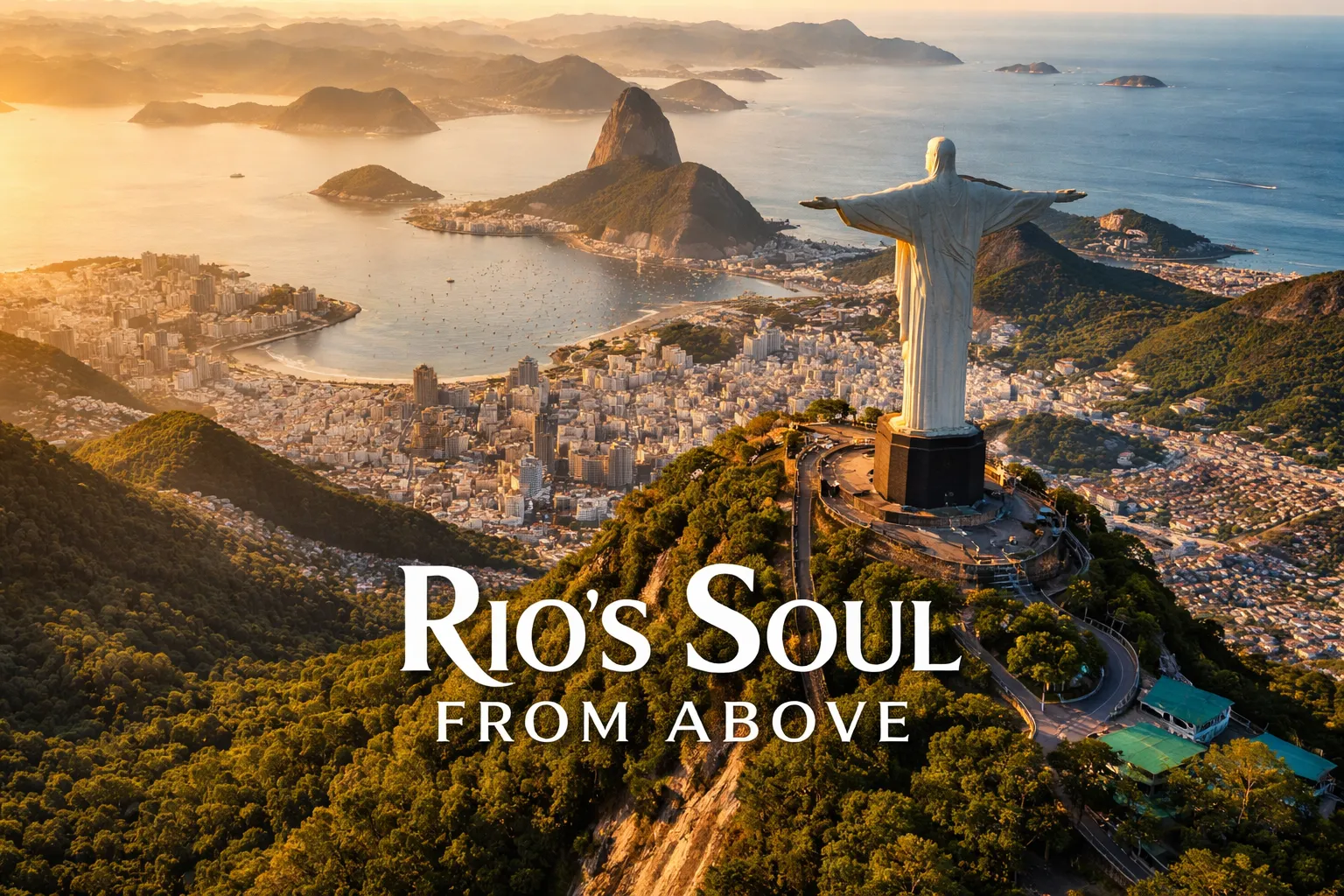
The first time I pushed the sticks forward and watched my drone rise above the Tijuca Forest canopy, nothing prepared me for what appeared on the screen. There he was — Cristo Redentor, arms outstretched, Guanabara Bay shimmering behind him, Sugarloaf Mountain rising like a sentinel to the south, and the entire sprawling geography of Rio de Janeiro laid out in a single, impossible frame. If you’ve been searching for the definitive christ the redeemer drone video guide — the kind that actually tells you what’s legal, where to fly, and which angles make professional cinematographers stop scrolling — you’ve found it. This is not a drone shot you stumble into. It rewards planning, patience, and an honest understanding of Brazil’s airspace rules.
Drone Flight Brief: Christ the Redeemer at a Glance
| GPS Coordinates (Corcovado Summit) | 22°57′06″S, 43°12′38″W |
| Legal Flying Zone (Mirante Dona Marta) | 22°57′28″S, 43°11′10″W |
| Recommended Altitude Range | 80–180m AGL from Mirante Dona Marta launch point |
| Best Time of Day | 6:30–9:00 AM (golden hour light, minimal cloud build-up) |
| Best Season | May through September (dry season, consistent visibility) |
| Drone Regulations Summary | Drones are BANNED at Corcovado Mountain and the immediate statue area (restricted airspace, Tijuca National Park). ANAC SISANT registration required for all drones over 250g. Flying from Mirante Dona Marta is the accepted legal alternative for distant aerial framing. |
| Skill Level Required | Advanced — high-altitude wind gusts, complex airspace, forest obstacles |
| Difficulty Rating | 8/10 |
Can You Fly a Drone at Christ the Redeemer?
Let me be completely direct: you cannot legally fly a drone over or near Corcovado Mountain and Christ the Redeemer statue. The statue sits within Tijuca National Park, which is a permanently protected area under Brazilian environmental law. On top of that, DECEA (the Brazilian airspace authority) has established restricted airspace over the Corcovado summit and its immediate surroundings. Brazil’s ANAC (Agência Nacional de Aviação Civil) requires all drone operators to register aircraft over 250g through the SISANT system before any flight anywhere in Brazil — this is non-negotiable and registration must be completed online before you travel. Violations carry fines and potential confiscation of equipment. I’ve spoken to production crews who attempted to negotiate special permits for the statue area, and the answer from IBAMA (the national environmental agency) has consistently been no for recreational and most commercial operators.
The good news: you don’t need to fly over the statue to capture a jaw-dropping christ redeemer aerial photography rio shot. Mirante Dona Marta — a public lookout point approximately 1.8 kilometers northeast of Corcovado at around 396m elevation — has become the accepted launch point for professional drone crews shooting the statue legally. From here, your drone can frame Cristo against the backdrop of Guanabara Bay at distances that still produce stunning compositions, especially with a telephoto lens option. Confirm current airspace status before every flight using the DECEA SARPAS authorization system, as temporary restrictions are issued frequently, particularly during major events in Rio.
What the Aerial View Reveals: Rio de Janeiro Landmarks From Above
Even from Mirante Dona Marta, what your drone reveals about Rio is genuinely revelatory. From ground level, Christ the Redeemer feels intimate and vertical — you crane your neck upward at a single monument. From altitude, the statue becomes a geographic anchor. You suddenly understand why this site was chosen in 1931: Corcovado is the visual center of an entire city-sized amphitheater. To the south, Sugarloaf Mountain (Pão de Açúcar) rises from the entrance of Guanabara Bay in perfect compositional balance. To the east, the bay stretches toward Niterói, its waters catching light differently depending on the hour. To the north and west, the Tijuca Forest — the largest urban rainforest in the world at 32 km² — forms an improbably green carpet interrupted by the gray grid of neighborhoods below.
What truly stops aerial photographers cold is the favela topography. Communities like Santa Marta, which climbs the hillside directly below Mirante Dona Marta, reveal their extraordinary density from above — thousands of rooftops stacked against each other in colors that ground-level photography cannot convey. The contrast between the untouched forest canopy, the packed urban hillside communities, the formal city grid at sea level, and the Atlantic coast beyond creates a layered composition that exists nowhere else on Earth. These are the rio de janeiro landmarks from above that make this city one of the most visually complex drone subjects in the world.
The Best Shots to Capture: Drone Flying from Corcovado Mountain Viewpoints
Professional cinematographers prize several specific compositions when working the Corcovado area. Here are the shots worth building your session around:
The Compressed Telephoto Frame
From Mirante Dona Marta at approximately 120–150m AGL, use your drone’s medium telephoto camera setting to compress the distance between the statue and Sugarloaf behind it. At this focal length, Cristo appears monumental in the foreground with the bay and Pão de Açúcar forming a perfect background layer. Shoot between 7:00–8:30 AM when the eastern sun rakes across the statue’s front face. This is the single most requested composition in commercial drone flying corcovado mountain work, and it reads beautifully in both still photography and video.
The Slow Orbit at Statue Level
This shot requires a permit and professional operator clearance — I’m including it here because it defines what professional productions shoot. At approximately 710m elevation (Corcovado summit level), a slow orbit around the statue as the drone maintains the same altitude reveals the profile transition: from the frontal outstretched arms to the side profile showing the statue’s three-dimensional form, to the rear view over the Atlantic. The transition from the favela-covered hillside to open ocean happens in a single 180-degree pan. If you’re producing a licensed commercial shoot and have secured DECEA authorization, plan the orbit at 50–60 meters radius from the statue’s base, flying at 5–7 km/h for cinematic smoothness.
The Pull-Away Reveal
Start tight on the statue (from your legal distance at Dona Marta), then slowly pull back and rise simultaneously while the camera tilts down. As altitude increases from 100m to 180m AGL, Rio’s full geography unrolls below the frame — the neighborhoods, the lagoon, the beaches of Ipanema and Copacabana, and finally the Atlantic horizon. This is the quintessential christ the redeemer drone video shot for travel content because it transitions the viewer from monument to city to ocean in a single movement. Execute this between 6:45–7:30 AM in the dry season for the warmest light and the highest probability of a clear horizon.
The Forest-to-City Transition
Launch from Mirante Dona Marta and fly westward over the Tijuca Forest canopy at 80–100m AGL, then turn back east toward the city. The boundary where the rainforest ends and the urban grid begins is one of the sharpest urban-natural contrasts you’ll find anywhere on Earth — and from 100m up, it fits in a single wide frame with Cristo visible on the ridgeline behind you. Shoot this in the late dry season (August–September) when haze is minimal and the forest canopy glows in saturated green.
Best Time to Photograph Christ the Redeemer From Above
The single most important variable for aerial photography at Corcovado is not light — it’s cloud cover. Rio sits in a tropical convergence zone, and orographic lift over Corcovado’s 710m summit means clouds form directly on the mountain with extraordinary speed, particularly from October through March (the wet season). By 10:00 AM on most summer days, Cristo is partially or fully shrouded. The dry season window of May through September offers the most reliable clear-sky mornings. Within that window, the optimal launch window from Mirante Dona Marta is 6:30–9:00 AM — golden hour light from the east illuminates the statue’s face directly, winds are typically calmer before the afternoon thermal cycles begin, and cloud build-up hasn’t started.
Wind is a serious consideration at this elevation. Corcovado and the surrounding ridges generate channeled gusts that can exceed 40 km/h without warning, even on ostensibly calm days. At 180m AGL from Dona Marta, you’re effectively at the same elevation as the upper Corcovado slopes, where ridge-effect wind acceleration is common. Always check WindyApp or Windy.com for the 850hPa pressure level winds (roughly 1,500m) rather than surface winds — they more accurately predict what you’ll encounter at drone operating altitude over Rio’s hills.
Best Drone Spots Rio de Janeiro: Expanding Beyond Corcovado
While Corcovado is the crown jewel, Rio rewards aerial photographers who explore its full geography. Here are the best drone spots rio de janeiro for your wider itinerary:
- Mirante Dona Marta — The legal sweet spot for Corcovado framing. A public viewpoint with parking and consistent cell signal for SARPAS authorization checks. Arrive before dawn to secure position.
- Prainha Beach (west of Barra da Tijuca) — One of Rio’s few beaches with relatively uncongested airspace for beach and coastline aerials. Less urban than Copacabana, with dramatic cliff lines that photograph beautifully at low altitude.
- Pedra Bonita (Tijuca Forest) — A hang-gliding launch point with legal drone access and extraordinary city-plus-forest framing. The elevation (696m) means you can shoot Rio’s Barra da Tijuca coastline with the Atlantic horizon at camera level.
- Niterói coastline across Guanabara Bay — Shooting westward from Niterói puts the entire Rio skyline, Sugarloaf, and Corcovado in a single wide frame with the bay as foreground. This is how professional travel campaigns frame the full Rio geography.
- Lagoa Rodrigo de Freitas — The urban lagoon flanked by Ipanema and the Corcovado ridgeline makes for striking drone compositions, though check NOTAM for event-related restrictions frequently — this area hosts major events year-round.
Gear Worth Packing for Christ Redeemer Aerial Photography Rio
The DJI Air 3S Fly More Combo with RC 2 Screen Remote Controller is the drone I would bring to Rio without hesitation, and the Fly More Combo configuration specifically matters here. Three batteries in the combo gives you genuine flexibility when shooting from Mirante Dona Marta — your first battery goes toward scouting the composition and testing wind conditions at altitude, your second goes toward your primary video runs, and your third is your insurance policy if cloud formations shift and you need to wait 20 minutes for a clear window. The RC 2 screen remote controller is not a luxury in Rio’s bright morning sun — it’s a necessity. Trying to read a smartphone screen in tropical sunlight at 7 AM while managing a drone near Corcovado’s ridgeline is how you lose situational awareness. The RC 2’s built-in screen stays legible, and that legibility directly translates to safer, more precise flying in a technically demanding environment.
If you want the most complete Rio aerial photography setup available, the DJI Air 3S Drone with RC 2 Fly More Combo Bundle — which includes a 128GB memory card, landing pad, backpack, CPS 2-year warranty, and lens cleaning kit — covers the specific pain points I’ve encountered shooting in tropical environments. The landing pad matters more than you’d expect at Dona Marta: the viewpoint surface is uneven concrete and gravel, and launching without a pad risks debris ingestion into the motors on takeoff. The 128GB card is sized correctly for the Air 3S’s 4K HDR files — you do not want to be card-swapping mid-session when a perfect cloud break appears over Cristo. The CPS 2-year warranty covers accidental damage, and given the wind conditions and operational complexity of flying near Corcovado, that coverage is not paranoia — it’s sensible risk management for a piece of equipment this valuable.
For travelers who want a capable, travel-optimized setup without the extended Fly More kit, the DJI Air 3S with RC-N3 Controller delivers the same 1″ CMOS sensor, 4K/60fps HDR video, and 14 stops of dynamic range in a slightly more streamlined package. The 14 stops of dynamic range is specifically important at Corcovado because Rio’s morning light creates an extreme contrast scenario: the statue in warm directional light, deep forest shadows below, and a bright sky horizon all in the same frame. Lesser sensors blow out the sky or crush the shadows — the Air 3S’s 1″ sensor retains detail across that entire range without graduated ND intervention. The 20km transmission range also means your RC-N3 signal remains solid even at maximum legal distances from Dona Marta, where you’re pushing the outer limits of telephoto framing of the statue.
Frequently Asked Questions
Can I fly a drone directly over Christ the Redeemer?
No. Drones are prohibited at Christ the Redeemer and over Corcovado Mountain due to a combination of restricted DECEA airspace and Tijuca National Park’s prohibition on drone operations within park boundaries. This applies to both recreational and most commercial operators. Special IBAMA and DECEA authorization is theoretically possible for licensed Brazilian production companies with strong institutional justification, but approvals are rare and the process is lengthy. The practical legal alternative is flying from Mirante Dona Marta, approximately 1.8km northeast of the statue, where you can capture compelling distant telephoto compositions without entering restricted airspace.
Do I need to register my drone to fly in Brazil?
Yes — any drone over 250g must be registered with Brazil’s ANAC through the SISANT online system before any flight in Brazilian airspace. Registration is completed at sistemas.anac.gov.br/sisant and requires basic personal identification and aircraft details. You must also check the DECEA SARPAS system for airspace authorization before each individual flight, as temporary flight restrictions and permanent restricted zones require specific clearance. Flying without SISANT registration is illegal and can result in fines and equipment confiscation. Complete both registrations before you travel, as the process can take several days.
What is the best season to film Christ the Redeemer from a drone?
May through September is definitively the best season for aerial photography around Corcovado. This is Rio’s dry season, and it offers the most consistent clear-sky mornings with minimal orographic cloud formation over the mountain. July and August typically offer the sharpest atmospheric clarity with the lowest humidity haze. The wet season (October through March) produces spectacular dramatic skies occasionally, but the probability of Cristo being cloud-covered on any given morning rises sharply — plan on 30–40% of mornings being unusable during the wet season versus roughly 10–15% in the heart of the dry season.