
| Data Point | Details |
|---|---|
| GPS Coordinates (El Castillo) | 20.6843° N, 88.5678° W |
| Recommended Altitude Range | 150–300m AGL for wide compositional shots; 80–120m for detail work on terraces (where legally permitted outside the restricted zone) |
| Best Time of Day | 06:30–08:30 local time for golden-hour light and minimal tourist shadows in approach corridors |
| Best Season | November–February (dry season); low humidity reduces haze and maximizes contrast between limestone and jungle canopy |
| Drone Regulations Summary | Drones are PROHIBITED within the Chichen Itza archaeological zone without explicit written authorization from INAH (Instituto Nacional de Antropología e Historia). Unauthorized flight is a federal offense under Mexican law. A small number of professional productions have obtained INAH flyover permits — this process is covered in detail below. |
| Skill Level Required | Advanced — legal overflight permits require demonstrated professional credentials; nearest legal drone zones require precise wind management and complex airspace awareness |
| Nearest Legal Drone Zones | Cenote Ik Kil (approx. 3km east), Cenote Suytun (approx. 10km east), private hacienda properties with written landowner permission |
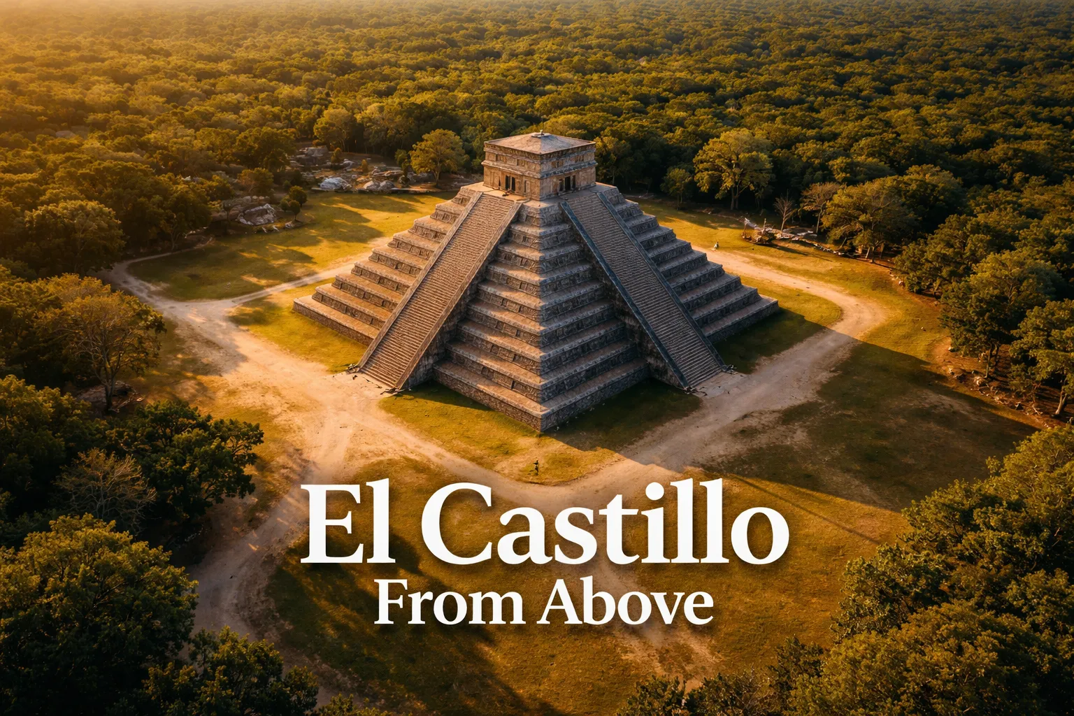
What the El Castillo Pyramid From Above Actually Reveals
Ground-level visitors to Chichen Itza see a stepped pyramid roughly 30 meters tall surrounded by a cleared plaza and a ring of secondary structures. It is impressive. From the air, it is something categorically different. The El Castillo pyramid from above exposes the full logic of what the Maya built here, and several phenomena that are either invisible or ambiguous at eye level become overwhelmingly clear from altitude.
The Mathematical Precision of the Structure
El Castillo has 365 steps total across its four stairways — one for each day of the solar year. Its 52 flat panels on each face correspond to the 52-year cycle of the Maya Calendar Round. The 18 terraces mirror the 18 months of the Haab solar calendar. From a drone at 200 meters, you can see all four faces simultaneously, and the bilateral symmetry of the structure is so precise that the human brain initially reads it as a computer-generated model. The corners align to within fractions of a degree with the cardinal directions, which becomes visible from above in a way that ground-level observation simply cannot convey.
The Equinox Shadow Effect Seen From the Air
The famous “serpent of light” effect — where the setting sun at the spring and autumn equinoxes (approximately March 20 and September 22) casts a series of triangular shadows along the northern balustrade that appear to animate a feathered serpent descending the pyramid — is viewed from the ground by thousands of visitors annually. From above, the aerial perspective reveals something the crowds cannot see: the full geometric shadow play across all four faces simultaneously. At the equinox, the northeastern corner of the pyramid casts a knife-edge shadow that divides the north face into precise dark and light triangles. From 150 meters, this looks like the pyramid is being bisected by a blade of light. It is one of the most remarkable things I have ever seen rendered on a drone monitor.
The Cenote System and the Jungle Reclaiming the Edges
A Chichen Itza aerial view from drone altitude also reveals the broader hydrological and archaeological context of the site. The Sacred Cenote (Cenote Sagrado) sits roughly 300 meters north of El Castillo and is visible from above as a perfectly circular dark disk cut into the limestone plateau. Beyond the excavated main plaza, the jungle resumes almost immediately, and from altitude, you can see dozens of unexcavated mounds rising through the canopy — lesser structures that researchers estimate number in the hundreds, most never fully explored. The contrast between the manicured plaza and the encroaching jungle makes for one of the most cinematically compelling aerial compositions in all of Mayan ruins drone photography.
Can You Fly a Drone at Chichen Itza? Regulations and the Honest Answer
The honest answer is: not without federal authorization, and obtaining that authorization is a serious bureaucratic and legal undertaking that most recreational photographers will not be able to complete. Here is exactly what the regulations say.
Chichen Itza is a UNESCO World Heritage Site administered by INAH under Mexican federal law. Under Mexico’s General Civil Aviation Law and the regulations published by AFAC (Agencia Federal de Aviación Civil), all unmanned aerial vehicle operations over archaeological zones require prior written authorization. Unauthorized drone operation over an INAH-protected site is classified as a federal violation and can result in equipment confiscation, substantial fines, and in serious cases, criminal charges under Mexico’s Federal Law on Archaeological, Artistic and Historical Zones and Monuments.
A small number of professional cinematography teams — primarily working for documentary productions, major travel media outlets, and Mexican tourism promotion bodies — have obtained INAH flyover permits. The process requires submitting a formal request to INAH’s national offices in Mexico City, providing proof of professional credentials and insurance, specifying exact flight parameters including altitude, duration, and equipment specifications, and demonstrating that the operation will not disturb the site or other visitors. Processing times have historically ranged from several weeks to several months. If you are a professional with a genuine production need, contact INAH’s Coordinación Nacional de Monumentos Históricos directly — the process is possible, just demanding.
For everyone else — and I include most working travel photographers in this category — the legal strategy is to photograph from the nearest accessible legal locations and to use the authorized aerial imagery that does exist (much of it available through INAH’s own media channels and licensed stock libraries) to complement your ground-level work.
Legal Drone Photography Near Chichen Itza: The Best Alternatives
The good news for Yucatan drone photography is that the region surrounding Chichen Itza contains several legally accessible locations that produce extraordinary aerial imagery — and in some cases, the shots from these locations are more visually interesting than a straight overhead view of the main pyramid would be.
Cenote Ik Kil: The Crown Jewel of Cenote Aerial Photography
Located approximately 3 kilometers east of Chichen Itza on the highway toward Valladolid, Cenote Ik Kil is one of the most photographed cenotes in the Yucatan — and from above, it earns every bit of that reputation. The cenote is an open-sky sinkhole roughly 60 meters in diameter and 40 meters deep, with hanging vines cascading from the rim and a vivid turquoise pool at the bottom where swimmers create brilliant color contrast. From a drone at 80–100 meters directly overhead, the cenote appears as a perfect dark circle with a luminous teal center, framed by jungle. The best altitude for photographing Cenote Ik Kil is 60–90 meters directly overhead, shot at solar noon when the sun penetrates the full depth of the opening and illuminates the water below. Always check with the site management regarding drone permissions before flying — policies can change seasonally. This is one of the genuinely spectacular shots available in all of Yucatan drone photography, and it serves as a powerful contextual companion to any Chichen Itza coverage.
Cenote Suytun: Light Beam Architecture From the Air
Cenote Suytun, near Valladolid, is famous at ground level for the light beam that pierces its ceiling aperture at midday and illuminates a stone platform above the water. From above, the cenote’s circular roof opening against the surrounding jungle canopy creates a striking bird’s-eye composition — a dark disk of vegetation with a perfect circle cut through it. The best aerial shots here are taken from 40–60 meters, looking straight down into the aperture during the 11:00–13:00 window when the light beam effect is most dramatic. Again, always confirm drone permission with management directly before flying. This location, paired with Ik Kil footage, gives your Chichen Itza content package a rich environmental and cultural depth that goes far beyond a single monument shot.
The Best Shots to Capture: Compositions, Altitudes, and Angles for Mayan Ruins Drone Photography
Whether you are working with authorized overflight footage, shooting from legal peripheral positions, or building a Yucatan content package around the legal cenote locations, these are the specific compositions that define world-class Mayan ruins drone photography in this region.
- The Pure Overhead at 200m: El Castillo from directly above, ideally at the moment of equinox, revealing the cross-shaped shadow geometry across all four faces. This is the authoritative establishing shot — the one that immediately communicates the pyramid’s mathematical perfection to a viewer who has never visited.
- The Jungle Context Shot at 280–300m: A wider altitude that places El Castillo within its full jungle setting, showing the cleared plaza surrounded by unexcavated mounds and recovering forest. This is the shot that makes people understand the scale of what was built here.
- The Low Oblique at 80m (35–45° angle): Coming in from the northeast at a shallow oblique angle during golden hour, this catches the long shadow of the pyramid stretching across the plaza and emphasizes the terraced geometry of the structure. This angle also reveals the Temple of Warriors and the Great Ball Court in the same frame.
- The Sacred Cenote Pull-Back: Starting directly above the Sacred Cenote and slowly pulling back to reveal El Castillo in the same frame — a single shot that encapsulates the hydrological and ceremonial relationship between the two sites.
- The Cenote Ik Kil Straight-Down at 85m: Shot at solar noon, the pure overhead of Ik Kil with a lone swimmer in the turquoise center provides both visual drama and human scale.
Gear Worth Packing for Chichen Itza and Yucatan Drone Photography
Drone photography in the Yucatan involves specific environmental stressors that make careful gear selection more important than at many other destinations. High humidity, unpredictable coastal wind behavior even well inland, and the consequences of a prop failure over a cenote or — hypothetically — over an irreplaceable archaeological site mean that redundancy and protection are not optional extras. Here is what I bring, and why each piece earned its place in the bag.
The Lovelysp Crash Guard Cover Bumper and Propeller Protector for DJI Tello is the piece of kit I recommend to anyone using the Tello as a learning or scouting drone before committing a larger platform to a challenging shot. What I have learned — sometimes the hard way — is that you never want to send your primary drone into an unfamiliar environment without having scouted the airspace first, and the Tello is a nimble, affordable scouting tool for tight spaces like cenote rims and jungle clearings. The propeller protectors on this set are genuinely robust, meaning that if the Tello clips a hanging vine at the edge of a cenote or catches unexpected backwash from a jungle updraft, you are likely to recover the drone rather than lose it. The four-piece crash guard configuration distributes impact force efficiently and keeps the blades from fragmenting on contact, which matters enormously when you are flying over water with no retrieval option. I learned to always mount these guards for any scouting run within 15 meters of vegetation — the one time I skipped them, I spent twenty minutes fishing a drone out of a cenote with a pool net borrowed from a very amused groundskeeper.
For operators running the DJI Air 3 or the newer Air 3S as their primary platform — which is my current setup for professional travel work — the Craznick Propellers for DJI Air 3S bundle is one of the most thoughtfully assembled accessory packages I have found. The bundle includes four low-noise replacement blades, propeller guards, and landing gear extensions — and in the Yucatan, all three components earn their weight. The low-noise blades matter more than you might think at a site like Chichen Itza, where any drone sound near the archaeological zone boundary draws immediate attention from site security; quieter blades in your legal approach corridors keep the operation professional and low-profile. The landing gear extensions are essential when operating from uneven jungle terrain or the rough limestone edges that characterize cenote approaches — a standard-height Air 3S landing on a textured stone rim without extended gear is a prop-strike waiting to happen. I always carry a spare full set of blades in the Yucatan because the humidity accelerates subtle blade warping over multiple flight days, and even small warping changes the harmonic balance of the drone in ways that show up as jello artifacts in 4K footage.
The Jakoly Propeller Guard for DJI Mini 5 Pro is the third piece of gear I want to highlight specifically for photographers who are travelling light and using the Mini 5 Pro as their sole drone — which is an increasingly common and smart choice for international travel given the Mini’s weight classification advantages. In Mexico, AFAC regulations treat sub-250g drones in a lighter regulatory category for recreational use, which gives Mini 5 Pro operators more flexibility in non-restricted areas like the cenotes near Chichen Itza. The Jakoly guards are purpose-built for the Mini 5 Pro’s specific prop geometry, which matters because generic guards can interfere with the motor mounts or create vibration resonance that degrades footage quality. At Cenote Suytun, where you are flying in a partially enclosed space with reflective limestone walls creating unpredictable acoustic bounce, having the guards on is the difference between a recoverable brush contact and a drone in the water. The replacement propeller cover set that comes in this package also means you are never stuck waiting for parts to be shipped to a Yucatan town with limited drone supply chains.
Planning Your Yucatan Drone Photography Trip: Practical Logistics
The optimal base for a Chichen Itza and Yucatan drone photography expedition is Valladolid, a colonial city roughly 40 kilometers east of the archaeological site. Valladolid gives you fast access to Cenote Suytun (10 minutes), Cenote Ik Kil (25 minutes), Chichen Itza itself (35 minutes), and a range of lesser-visited cenotes along the Ring of Cenotes geological formation that are outstanding drone subjects in their own right. The dry season from November through February produces the most reliable morning light, lowest humidity, and most manageable wind conditions. Humidity is the single biggest challenge in the Yucatan: midday heat and moisture haze can reduce effective contrast and detail in footage dramatically, which is why the 06:30–09:00 golden hour window and the late afternoon 16:30–18:30 window are so valuable.
Bring more batteries than you think you need — the heat accelerates battery discharge, and 20-minute flight windows become 15-minute windows in peak humidity. Always carry your drone’s documentation, including purchase receipts and specification sheets that confirm weight classifications, since Mexican customs and site security may ask
This post contains affiliate links. As an Amazon Associate, I earn from qualifying purchases at no extra cost to you.
There is a moment — and every aerial photographer who has hovered over an ancient wonder knows it — when the monitor on your controller shows you something that no human eye has seen in a thousand years. For me, that moment came the first time I pulled up footage from a legally authorized overflight near Chichen Itza and watched El Castillo resolve out of the jungle canopy like a geometric proof carved in limestone. Chichen Itza drone aerial photography is one of the most sought-after disciplines in the world of travel aerial work, and for good reason: from altitude, the Pyramid of Kukulcán stops being a tourist landmark and becomes something almost alien — a machine of mathematical precision embedded in ten square kilometers of recovering rainforest. The symmetry is absolute. The shadow geometry is staggering. And the regulated airspace above it means that capturing it legally requires planning, patience, and a thorough understanding of Mexican aviation law before you ever unpack your case.
Chichen Itza Drone Aerial Photography: Quick-Reference Flight Brief
Before we go any deeper, here is the structured data every aerial photographer needs before visiting the site. Read this section carefully — particularly the regulations row — because the rules here are non-negotiable and enforced.
| Data Point | Details |
|---|---|
| GPS Coordinates (El Castillo) | 20.6843° N, 88.5678° W |
| Recommended Altitude Range | 150–300m AGL for wide compositional shots; 80–120m for detail work on terraces (where legally permitted outside the restricted zone) |
| Best Time of Day | 06:30–08:30 local time for golden-hour light and minimal tourist shadows in approach corridors |
| Best Season | November–February (dry season); low humidity reduces haze and maximizes contrast between limestone and jungle canopy |
| Drone Regulations Summary | Drones are PROHIBITED within the Chichen Itza archaeological zone without explicit written authorization from INAH (Instituto Nacional de Antropología e Historia). Unauthorized flight is a federal offense under Mexican law. A small number of professional productions have obtained INAH flyover permits — this process is covered in detail below. |
| Skill Level Required | Advanced — legal overflight permits require demonstrated professional credentials; nearest legal drone zones require precise wind management and complex airspace awareness |
| Nearest Legal Drone Zones | Cenote Ik Kil (approx. 3km east), Cenote Suytun (approx. 10km east), private hacienda properties with written landowner permission |
What the El Castillo Pyramid From Above Actually Reveals
Ground-level visitors to Chichen Itza see a stepped pyramid roughly 30 meters tall surrounded by a cleared plaza and a ring of secondary structures. It is impressive. From the air, it is something categorically different. The El Castillo pyramid from above exposes the full logic of what the Maya built here, and several phenomena that are either invisible or ambiguous at eye level become overwhelmingly clear from altitude.
The Mathematical Precision of the Structure
El Castillo has 365 steps total across its four stairways — one for each day of the solar year. Its 52 flat panels on each face correspond to the 52-year cycle of the Maya Calendar Round. The 18 terraces mirror the 18 months of the Haab solar calendar. From a drone at 200 meters, you can see all four faces simultaneously, and the bilateral symmetry of the structure is so precise that the human brain initially reads it as a computer-generated model. The corners align to within fractions of a degree with the cardinal directions, which becomes visible from above in a way that ground-level observation simply cannot convey.
The Equinox Shadow Effect Seen From the Air
The famous “serpent of light” effect — where the setting sun at the spring and autumn equinoxes (approximately March 20 and September 22) casts a series of triangular shadows along the northern balustrade that appear to animate a feathered serpent descending the pyramid — is viewed from the ground by thousands of visitors annually. From above, the aerial perspective reveals something the crowds cannot see: the full geometric shadow play across all four faces simultaneously. At the equinox, the northeastern corner of the pyramid casts a knife-edge shadow that divides the north face into precise dark and light triangles. From 150 meters, this looks like the pyramid is being bisected by a blade of light. It is one of the most remarkable things I have ever seen rendered on a drone monitor.
The Cenote System and the Jungle Reclaiming the Edges
A Chichen Itza aerial view from drone altitude also reveals the broader hydrological and archaeological context of the site. The Sacred Cenote (Cenote Sagrado) sits roughly 300 meters north of El Castillo and is visible from above as a perfectly circular dark disk cut into the limestone plateau. Beyond the excavated main plaza, the jungle resumes almost immediately, and from altitude, you can see dozens of unexcavated mounds rising through the canopy — lesser structures that researchers estimate number in the hundreds, most never fully explored. The contrast between the manicured plaza and the encroaching jungle makes for one of the most cinematically compelling aerial compositions in all of Mayan ruins drone photography.
Can You Fly a Drone at Chichen Itza? Regulations and the Honest Answer
The honest answer is: not without federal authorization, and obtaining that authorization is a serious bureaucratic and legal undertaking that most recreational photographers will not be able to complete. Here is exactly what the regulations say.
Chichen Itza is a UNESCO World Heritage Site administered by INAH under Mexican federal law. Under Mexico’s General Civil Aviation Law and the regulations published by AFAC (Agencia Federal de Aviación Civil), all unmanned aerial vehicle operations over archaeological zones require prior written authorization. Unauthorized drone operation over an INAH-protected site is classified as a federal violation and can result in equipment confiscation, substantial fines, and in serious cases, criminal charges under Mexico’s Federal Law on Archaeological, Artistic and Historical Zones and Monuments.
A small number of professional cinematography teams — primarily working for documentary productions, major travel media outlets, and Mexican tourism promotion bodies — have obtained INAH flyover permits. The process requires submitting a formal request to INAH’s national offices in Mexico City, providing proof of professional credentials and insurance, specifying exact flight parameters including altitude, duration, and equipment specifications, and demonstrating that the operation will not disturb the site or other visitors. Processing times have historically ranged from several weeks to several months. If you are a professional with a genuine production need, contact INAH’s Coordinación Nacional de Monumentos Históricos directly — the process is possible, just demanding.
For everyone else — and I include most working travel photographers in this category — the legal strategy is to photograph from the nearest accessible legal locations and to use the authorized aerial imagery that does exist (much of it available through INAH’s own media channels and licensed stock libraries) to complement your ground-level work.
Legal Drone Photography Near Chichen Itza: The Best Alternatives
The good news for Yucatan drone photography is that the region surrounding Chichen Itza contains several legally accessible locations that produce extraordinary aerial imagery — and in some cases, the shots from these locations are more visually interesting than a straight overhead view of the main pyramid would be.
Cenote Ik Kil: The Crown Jewel of Cenote Aerial Photography
Located approximately 3 kilometers east of Chichen Itza on the highway toward Valladolid, Cenote Ik Kil is one of the most photographed cenotes in the Yucatan — and from above, it earns every bit of that reputation. The cenote is an open-sky sinkhole roughly 60 meters in diameter and 40 meters deep, with hanging vines cascading from the rim and a vivid turquoise pool at the bottom where swimmers create brilliant color contrast. From a drone at 80–100 meters directly overhead, the cenote appears as a perfect dark circle with a luminous teal center, framed by jungle. The best altitude for photographing Cenote Ik Kil is 60–90 meters directly overhead, shot at solar noon when the sun penetrates the full depth of the opening and illuminates the water below. Always check with the site management regarding drone permissions before flying — policies can change seasonally. This is one of the genuinely spectacular shots available in all of Yucatan drone photography, and it serves as a powerful contextual companion to any Chichen Itza coverage.
Cenote Suytun: Light Beam Architecture From the Air
Cenote Suytun, near Valladolid, is famous at ground level for the light beam that pierces its ceiling aperture at midday and illuminates a stone platform above the water. From above, the cenote’s circular roof opening against the surrounding jungle canopy creates a striking bird’s-eye composition — a dark disk of vegetation with a perfect circle cut through it. The best aerial shots here are taken from 40–60 meters, looking straight down into the aperture during the 11:00–13:00 window when the light beam effect is most dramatic. Again, always confirm drone permission with management directly before flying. This location, paired with Ik Kil footage, gives your Chichen Itza content package a rich environmental and cultural depth that goes far beyond a single monument shot.
The Best Shots to Capture: Compositions, Altitudes, and Angles for Mayan Ruins Drone Photography
Whether you are working with authorized overflight footage, shooting from legal peripheral positions, or building a Yucatan content package around the legal cenote locations, these are the specific compositions that define world-class Mayan ruins drone photography in this region.
- The Pure Overhead at 200m: El Castillo from directly above, ideally at the moment of equinox, revealing the cross-shaped shadow geometry across all four faces. This is the authoritative establishing shot — the one that immediately communicates the pyramid’s mathematical perfection to a viewer who has never visited.
- The Jungle Context Shot at 280–300m: A wider altitude that places El Castillo within its full jungle setting, showing the cleared plaza surrounded by unexcavated mounds and recovering forest. This is the shot that makes people understand the scale of what was built here.
- The Low Oblique at 80m (35–45° angle): Coming in from the northeast at a shallow oblique angle during golden hour, this catches the long shadow of the pyramid stretching across the plaza and emphasizes the terraced geometry of the structure. This angle also reveals the Temple of Warriors and the Great Ball Court in the same frame.
- The Sacred Cenote Pull-Back: Starting directly above the Sacred Cenote and slowly pulling back to reveal El Castillo in the same frame — a single shot that encapsulates the hydrological and ceremonial relationship between the two sites.
- The Cenote Ik Kil Straight-Down at 85m: Shot at solar noon, the pure overhead of Ik Kil with a lone swimmer in the turquoise center provides both visual drama and human scale.
Gear Worth Packing for Chichen Itza and Yucatan Drone Photography
Drone photography in the Yucatan involves specific environmental stressors that make careful gear selection more important than at many other destinations. High humidity, unpredictable coastal wind behavior even well inland, and the consequences of a prop failure over a cenote or — hypothetically — over an irreplaceable archaeological site mean that redundancy and protection are not optional extras. Here is what I bring, and why each piece earned its place in the bag.
The Lovelysp Crash Guard Cover Bumper and Propeller Protector for DJI Tello is the piece of kit I recommend to anyone using the Tello as a learning or scouting drone before committing a larger platform to a challenging shot. What I have learned — sometimes the hard way — is that you never want to send your primary drone into an unfamiliar environment without having scouted the airspace first, and the Tello is a nimble, affordable scouting tool for tight spaces like cenote rims and jungle clearings. The propeller protectors on this set are genuinely robust, meaning that if the Tello clips a hanging vine at the edge of a cenote or catches unexpected backwash from a jungle updraft, you are likely to recover the drone rather than lose it. The four-piece crash guard configuration distributes impact force efficiently and keeps the blades from fragmenting on contact, which matters enormously when you are flying over water with no retrieval option. I learned to always mount these guards for any scouting run within 15 meters of vegetation — the one time I skipped them, I spent twenty minutes fishing a drone out of a cenote with a pool net borrowed from a very amused groundskeeper.
For operators running the DJI Air 3 or the newer Air 3S as their primary platform — which is my current setup for professional travel work — the Craznick Propellers for DJI Air 3S bundle is one of the most thoughtfully assembled accessory packages I have found. The bundle includes four low-noise replacement blades, propeller guards, and landing gear extensions — and in the Yucatan, all three components earn their weight. The low-noise blades matter more than you might think at a site like Chichen Itza, where any drone sound near the archaeological zone boundary draws immediate attention from site security; quieter blades in your legal approach corridors keep the operation professional and low-profile. The landing gear extensions are essential when operating from uneven jungle terrain or the rough limestone edges that characterize cenote approaches — a standard-height Air 3S landing on a textured stone rim without extended gear is a prop-strike waiting to happen. I always carry a spare full set of blades in the Yucatan because the humidity accelerates subtle blade warping over multiple flight days, and even small warping changes the harmonic balance of the drone in ways that show up as jello artifacts in 4K footage.
The Jakoly Propeller Guard for DJI Mini 5 Pro is the third piece of gear I want to highlight specifically for photographers who are travelling light and using the Mini 5 Pro as their sole drone — which is an increasingly common and smart choice for international travel given the Mini’s weight classification advantages. In Mexico, AFAC regulations treat sub-250g drones in a lighter regulatory category for recreational use, which gives Mini 5 Pro operators more flexibility in non-restricted areas like the cenotes near Chichen Itza. The Jakoly guards are purpose-built for the Mini 5 Pro’s specific prop geometry, which matters because generic guards can interfere with the motor mounts or create vibration resonance that degrades footage quality. At Cenote Suytun, where you are flying in a partially enclosed space with reflective limestone walls creating unpredictable acoustic bounce, having the guards on is the difference between a recoverable brush contact and a drone in the water. The replacement propeller cover set that comes in this package also means you are never stuck waiting for parts to be shipped to a Yucatan town with limited drone supply chains.
Planning Your Yucatan Drone Photography Trip: Practical Logistics
The optimal base for a Chichen Itza and Yucatan drone photography expedition is Valladolid, a colonial city roughly 40 kilometers east of the archaeological site. Valladolid gives you fast access to Cenote Suytun (10 minutes), Cenote Ik Kil (25 minutes), Chichen Itza itself (35 minutes), and a range of lesser-visited cenotes along the Ring of Cenotes geological formation that are outstanding drone subjects in their own right. The dry season from November through February produces the most reliable morning light, lowest humidity, and most manageable wind conditions. Humidity is the single biggest challenge in the Yucatan: midday heat and moisture haze can reduce effective contrast and detail in footage dramatically, which is why the 06:30–09:00 golden hour window and the late afternoon 16:30–18:30 window are so valuable.
Bring more batteries than you think you need — the heat accelerates battery discharge, and 20-minute flight windows become 15-minute windows in peak humidity. Always carry your drone’s documentation, including purchase receipts and specification sheets that confirm weight classifications, since Mexican customs and site security may ask