
Moraine Lake Drone Photography: Canada’s Turquoise Crown
The first time I understood what Moraine Lake truly looked like, I wasn’t standing on the famous rockpile viewpoint with a hundred other photographers. I was reviewing footage from a helicopter charter, watching the turquoise unfold beneath me like something poured from a chemistry experiment — impossibly vivid, impossibly real. That moment is exactly why moraine lake drone photography canada has become one of the most searched aerial photography topics in North America. From the ground, Moraine Lake is beautiful. From the air, it becomes a revelation — a color-saturated masterclass in glacial geology that no ground-based photograph can fully capture. This guide covers everything you need to know before you pack your gear: what you’ll see from altitude, the honest truth about regulations, and how to get those shots legally.
Drone Flight Brief: Moraine Lake, Banff National Park
| GPS Coordinates | 51.3217° N, 116.1860° W |
| Elevation | 1,884 m (6,183 ft) above sea level |
| Recommended Altitude Range | 150–350 m AGL for full Valley of Ten Peaks context; 60–100 m AGL for close color/texture detail |
| Best Time of Day | 6:00–8:30 AM (golden hour light from the east, mirror-calm water before afternoon winds) |
| Best Season | Late June through mid-September; peak rock flour concentration July–August produces the most saturated turquoise |
| Drone Regulations | ⛔ DRONES ARE BANNED inside Banff National Park without a Parks Canada filming permit. Recreational drone use is prohibited in all Canadian National Parks under the Canada National Parks Act. Commercial operators must apply for a Filming Permit through Parks Canada — approvals are rare and heavily restricted near sensitive wildlife areas. |
| Legal Alternatives | Helicopter charters from Banff/Canmore; Spray Lakes Provincial Recreation Area (outside park boundary); Lake Louise corridor from approved zones; Mt. Norquay area research |
| Skill Level Required | Advanced — high altitude, unpredictable mountain thermals, limited GPS interference recovery, cold temperature battery drain |
| Difficulty Rating | ⭐⭐⭐⭐⭐ (Expert conditions even for legal alternatives) |
What the Moraine Lake Aerial View Reveals That Ground Photography Cannot
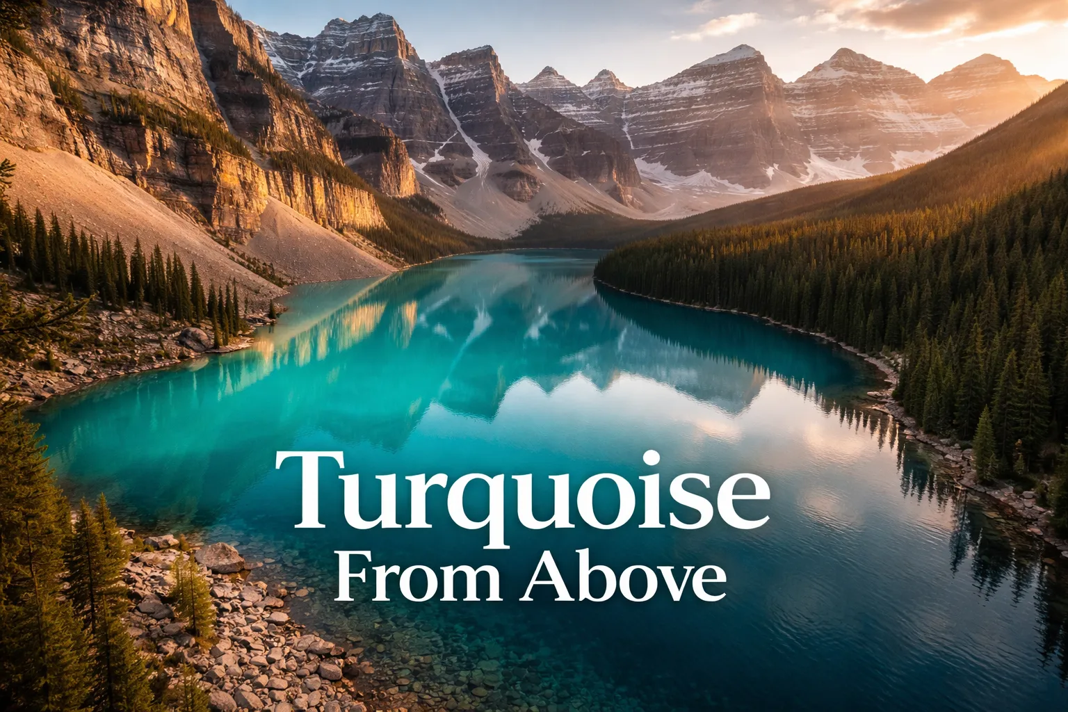
Standing at the rockpile viewpoint, you see Moraine Lake framed between a foreground of boulders and the ten peaks rising behind it. It’s gorgeous. But you’re missing roughly 80% of the story. From altitude — even from a helicopter at 250 metres — the lake transforms from a scenic backdrop into a scientific diagram you can actually read. The moraine itself, the massive debris pile of rock and sediment left by glacial activity thousands of years ago, is clearly visible as a natural dam plugging the valley’s lower end. From the ground, it’s just the hill you climbed to get the shot. From the air, you understand immediately why the lake exists at all.
The color gradient is the true aerial revelation. The glacial rock flour — ultra-fine sediment ground by glaciers and suspended in the meltwater — refracts light at specific wavelengths depending on its concentration and the water depth beneath it. From altitude, you can see this gradient in real time: the shallow margins near the moraine shore run pale aquamarine, almost mint green. Moving toward the center, the color deepens through vivid cyan into a rich sapphire blue where the lake floor drops sharply. No ground-level photograph shows you the full spectrum simultaneously. It’s the difference between seeing a gemstone and seeing the geological process that created it.
The valley of ten peaks from above also reads completely differently from altitude. What looks like a single dramatic backdrop from the shore reveals itself as a complex three-dimensional cirque — a horseshoe of peaks with distinct glacial pockets, snow fields at varying elevations, and avalanche chutes cutting pale lines down dark rock faces. The lake sits at the center of this natural amphitheater, and only from above can you appreciate that it’s completely enclosed — a jewel placed deliberately in a stone crown. This is the shot that makes the canadian rockies drone photography community so obsessed with this location.
Can You Fly a Drone at Moraine Lake? Regulations and the Honest Truth
Let me be absolutely direct with you: recreational drone flight is prohibited at Moraine Lake and throughout Banff National Park. This is not a grey area, a local bylaw, or a guideline — it is federal law under the Canada National Parks Act and enforced by Parks Canada wardens. Violations can result on-the-spot fines starting at $250 and escalating to several thousand dollars for repeat or egregious offences. Beyond the legal risk, flying a drone in this ecosystem genuinely threatens wildlife — golden eagles, grizzly bears, and peregrine falcons nest in the Valley of Ten Peaks corridor, and low-altitude drone disturbance has documented impacts on nesting behaviour.
Commercial operators — including professional videographers and photographers working on paid projects — can apply for a Filming Permit through Parks Canada’s Visitor Experience team. These permits are issued on a case-by-case basis, require proof of liability insurance (typically $2 million CAD minimum), a detailed shoot plan, and are almost never granted in ecologically sensitive zones or during wildlife activity seasons. The application process takes weeks, and approvals near Moraine Lake specifically are exceptionally rare. If you’re a working commercial operator, start the permit application at least 90 days before your intended shoot date at the Parks Canada official website.
The good news: legal aerial photography of this landscape is absolutely achievable, and in some ways, the alternatives produce better results. Helicopter charter flights out of Canmore and Banff offer doors-off or window-removed shooting configurations, putting you at controlled altitudes with a professional pilot who knows the mountain thermals. Several operators specifically market photography charters to aerial photographers. Spray Lakes Wildland Provincial Park, located southwest of Canmore outside the national park boundary, offers legal drone flying with its own spectacular Rocky Mountain scenery. It is worth noting that Transport Canada drone regulations (requiring Basic or Advanced RPAS certification depending on controlled airspace proximity) still apply everywhere in Canada — inside or outside national parks.
The Best Aerial Shots to Capture: Compositions, Altitudes, and Angles
Whether you’re in a helicopter or operating legally near the park boundary, these are the compositions that define moraine lake aerial view banff photography at its highest level. For each shot, I’m giving you specific altitude recommendations based on what actually works — not theoretical guesses.
The Color Gradient Straight-Down Shot (Nadir/Overhead)
The best altitude for a straight-down overhead shot of Moraine Lake’s color gradient is 200–280 metres AGL. Below 200 metres, you lose the full lake in frame. Above 300 metres, atmospheric haze begins to desaturate the turquoise, especially in mid-morning light. Shoot at 6:30–7:30 AM when the sun is low enough to create oblique light across the water surface — this enhances the depth contrast between the shallow turquoise margins and the deep sapphire center. A polarising filter, if your camera system supports one, reduces surface glare and pushes the color saturation another 15–20% beyond what post-processing can recover.
The Valley Reveal: Ten Peaks in Context
At 300–350 metres AGL, positioning your camera at roughly 45 degrees looking northwest from a position above the lake’s eastern moraine end, you can capture the full valley context: all ten peaks visible, the lake as a turquoise comma in the valley floor, and the conifer forests forming a deep green frame. This is the shot that makes viewers genuinely understand the scale of the landscape. Early morning is non-negotiable here — afternoon light comes from behind the peaks, throwing the faces into shadow and flattening the three-dimensionality that makes this composition extraordinary.
The Moraine Dam Detail Shot
At 80–120 metres AGL over the moraine itself, a 45-degree downward angle reveals the boulder field that created the lake — a feature completely invisible from shore-level photography. This is a genuinely educational shot, the kind that performs exceptionally well on editorial platforms and travel publications because it tells a geological story. Morning light rakes across the boulder surfaces, creating shadow texture that makes the rock pile read as three-dimensional rather than flat.
Banff National Park Drone Spots: Legal Alternatives Worth Exploring
If Moraine Lake is your primary target but you want to incorporate legal drone flying into your Banff trip, here are the most productive options. Spray Lakes Wildland Provincial Park, about 45 minutes southwest of Canmore via Highway 742 (the Smith-Dorrien/Spray Trail), sits entirely outside national park jurisdiction and offers dramatic Rocky Mountain scenery — jagged ridgelines, turquoise reservoirs, and alpine meadows — that competes with anything inside the park boundaries. This is one of the genuinely underused banff national park drone spots in the broader region, and it rewards early arrivals heavily.
The Kananaskis Country provincial recreation areas offer another strong option — Barrier Lake and Upper Kananaskis Lake in particular produce Rocky Mountain aerial imagery that reads as comparable to Banff on screen. Peter Lougheed Provincial Park within Kananaskis has its own stunning alpine lake scenery. Always verify current drone regulations with Alberta Parks before flying, as temporary flight restrictions can be issued for wildfire operations or wildlife protection without much advance notice. The broader canadian rockies drone photography community has developed strong resources around these provincial alternatives precisely because the national park restrictions are so comprehensive.
Gear Worth Packing for Cold-Altitude Rocky Mountain Aerial Photography
Mountain aerial photography has a way of exposing every weakness in your kit simultaneously — cold temperatures drain batteries, thermals challenge stability, and the light windows are brutally short. Here is the gear I rely on for this environment, with honest explanations of why each piece matters specifically here.
The shenruifa Drone Battery Constant Temperature Heating Bag is non-negotiable for Rocky Mountain flying at elevation — and I say that having learned the hard lesson without one. At Moraine Lake’s elevation of 1,884 metres, overnight temperatures even in July regularly drop below 5°C, and batteries stored in a cold pack or vehicle overnight arrive at your dawn shoot at 30–40% reduced capacity before you’ve taken a single flight. This USB-powered thermal warming bag brings your batteries up to optimal operating temperature before launch, meaning you start each flight with full-rated capacity rather than cold-degraded performance. Compatible with DJI NEO and Avata series systems, it plugs into any USB-A power bank — something you should already be carrying. In a location where your shooting window is 90 minutes of ideal morning light, losing a battery to cold is losing an irreplaceable opportunity. This bag has paid for itself many times over in recovered flight time.
For DJI Mini series operators, the Dalkat Dalee 2-Pack Mini 4K Intelligent Flight Battery for DJI Mini 2 / SE / 4K / 2 SE gives you a critical insurance policy in mountain environments where return-to-home scenarios are more frequent and battery performance is less predictable. Each battery delivers up to 31 minutes of rated flight time, and having two in your bag means you can safely execute a full morning session — the moraine overview flight, the color gradient nadir shot, and a Valley of Ten Peaks reveal — without returning to your vehicle. These are intelligent batteries with built-in discharge protection, meaning they won’t over-discharge during storage, which matters enormously if you’re packing them through a multi-day backcountry or travel itinerary before your shoot day arrives. The upgrade to 2400mAh over standard capacity gives you meaningful buffer when thin mountain air and cold temperatures are both working against your rated flight time. Two batteries is the minimum I’d recommend for any serious aerial photography session at elevation; this pack gets you there without duplicating costs.
For photographers using compact consumer quadcopters as backup or B-camera systems — something I strongly advocate for scouting compositions before committing a larger rig — the sea jump 3PCS 3.7V 1000mAh Lipo Battery set solves the single biggest frustration with budget drones in remote locations: you’re always one dead battery away from a grounded afternoon. Compatible with a wide range of popular recreational quadcopters including E88, E88MAX, E99, E99MAX, and K10MAX series, this three-pack with included USB charging cables means you can rotate through a full charge cycle using nothing but a power bank while hiking to your next location. At Rocky Mountain trailheads where outlets are nonexistent and your vehicle may be an hour’s walk away, that self-contained charging setup is genuinely valuable. These high-capacity cells are also more cold-tolerant than the standard OEM batteries that ship with budget drones — a meaningful difference when temperatures drop to near-freezing at your 6 AM launch window.
Best Time for Moraine Lake Aerial Photography: Seasons and Light
The definitive best season for aerial photography of Moraine Lake is mid-July through mid-August. This window captures peak glacial rock flour concentration in the water — the suspended sediment is at its densest as summer melt rates are highest — producing the most saturated turquoise visible from altitude. Early in the season (late June), the lake may still have ice patches and the color is less intense as meltwater dilutes the flour concentration. By mid-September, rock flour levels begin dropping and the color gradually shifts toward a less saturated teal-grey.
Within any given day, the best aerial photography window is 5:45 AM to 8:30 AM. Mountain thermals in the Canadian Rockies typically begin building after 9:00 AM as sun-heated valley walls create unpredictable updrafts. Morning wind is generally calm and consistent, allowing for stable hovering shots and precise altitude control. The low sun angle from the east creates shadow definition across the moraine boulder field and rakes light across the Valley of Ten Peaks faces at a flattering angle. By 10:00 AM, the direct overhead light flattens texture and the popular viewpoints fill with visitors — not a concern for aerial photography technically, but a reminder that the conditions that make ground photography difficult also affect the quality of aerial images.
This post contains affiliate links. As an Amazon Associate, I earn from qualifying purchases at no extra cost to you.
Frequently Asked Questions About Moraine Lake Drone Photography
Is drone flying legal at Moraine Lake in Banff National Park?
No. Recreational drone flying is completely prohibited in Banff National Park and all Canadian National Parks under the Canada National Parks Act. Commercial operators can apply for a Filming Permit through Parks Canada, but approvals are rare, take weeks to process, and require substantial liability insurance. Violations can result in fines of $250 to several thousand dollars. The legal alternative is to hire a helicopter charter for aerial photography, which is permitted, or to fly in adjacent provincial recreation areas such as Kananaskis Country or Spray Lakes Wildland Provincial Park.
Why is Moraine Lake such a distinctive turquoise color from above?
The turquoise color is caused by glacial rock flour — ultra-fine mineral particles ground by glaciers and suspended in the meltwater that feeds the lake. This suspended sediment refracts and reflects specific wavelengths of sunlight, producing the vivid cyan-to-turquoise spectrum visible both from ground level and from the air. From altitude, the color gradient is especially dramatic: shallow margins near the moraine shore appear pale aquamarine, while the deeper center of the lake shifts toward a rich sapphire blue. The color is most intense in mid-summer (July–August) when glacial melt rates are highest and rock flour concentration peaks.
What is the best altitude range for aerial photography of Moraine Lake?
For capturing the full lake with the Valley of Ten Peaks in context, the best altitude is 250–350 metres AGL. For close-up color gradient and texture detail shots, 60–120 metres AGL produces the most striking images. The optimal overhead (nadir) color gradient shot