
| GPS Coordinates | 29.9792° N, 31.1342° E (Khufu Pyramid apex reference point) |
| Recommended Altitude Range | 80–250 meters for wide context shots; 30–60 meters for structural detail |
| Best Time of Day | Sunrise (30 minutes before to 45 minutes after) for shadow geometry; golden hour before sunset for warm stone tones |
| Best Season | October–March (lower haze, cooler temperatures, softer light; March/September equinoxes for dramatic shadow alignment) |
| Drone Regulations Summary | Drones are RESTRICTED at Giza. Commercial and serious hobbyist flights require advance permits from Egypt’s Ministry of Tourism and Antiquities and coordination with the Egyptian Civil Aviation Authority (ECAA). Unauthorized drone flying over the pyramids is illegal and enforced. Permits are obtainable but require significant lead time (weeks to months). Full details below. |
| Skill Level Required | Intermediate to Advanced — strong winds at altitude, significant no-fly zone awareness, and military zone proximity demand confident piloting |
| Nearest Airport (NOTAM awareness) | Cairo International Airport (CAI) — ~22 km northeast; airspace coordination is mandatory |
What the Pyramids of Giza Aerial View Actually Reveals
From the ground, the Great Pyramid is overwhelming in the worst possible way for photography — you are too close, too small, and too unable to establish a frame that communicates scale meaningfully. The pyramids of giza aerial view dismantles every misunderstanding you had at ground level and replaces it with hard geometric truth.
The first thing that strikes you from altitude is the cardinal alignment. The Great Pyramid’s four sides align to true north with an accuracy of 0.05 degrees — a margin of error so small that modern surveyors using GPS equipment struggle to explain how it was achieved. From directly above at 150–200 meters, this alignment becomes visually undeniable. The edges don’t drift. They don’t approximate. They point. It is one of those aerial observations that shifts the experience from photography into something more like archaeological confrontation.
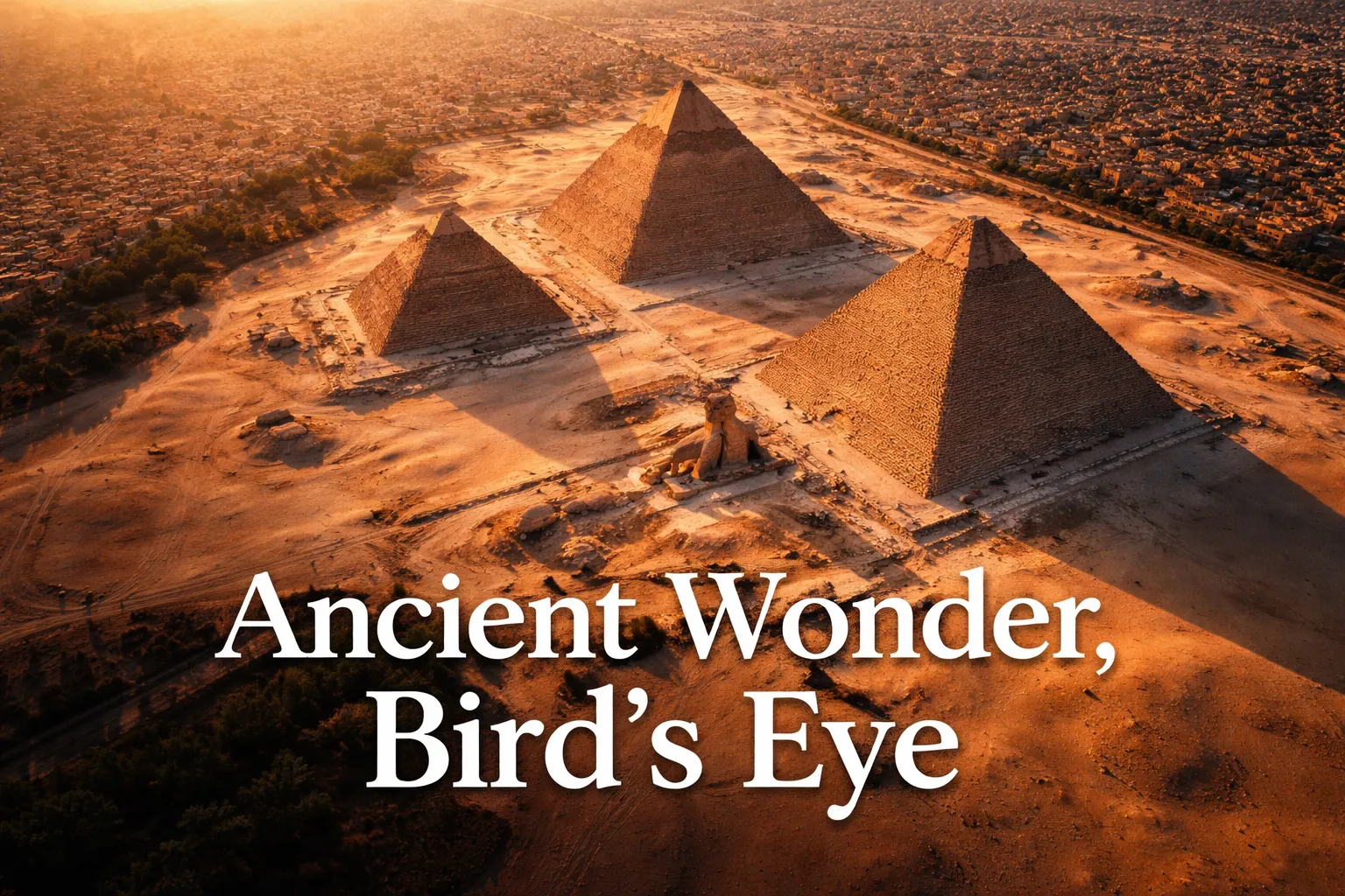
From the air, you also finally understand the Giza pyramid complex from above as a designed system rather than three separate structures. The three main pyramids — Khufu, Khafre, and Menkaure — are arranged in a deliberate diagonal pattern that some researchers argue mirrors the belt stars of Orion’s constellation. Whether you subscribe to that theory or not, the intentionality of the layout is undeniable when viewed from 200 meters. The causeways connecting each pyramid to its valley temple cut ruler-straight lines across the plateau. The six satellite pyramids clustered on the east and south sides of the complex only become legible as satellites from altitude — from the ground they read as rubble mounds.
Then there is the context shot that changes everything: the boundary between ancient and modern. Cairo’s dense urban grid presses up against the Giza Plateau so aggressively that from a drone, you can frame a shot with apartment blocks and fast food signage in the same frame as a 4,500-year-old wonder. No single image better communicates the improbability of the pyramids’ survival — or the urgency of their preservation — than this juxtaposition captured from 120 meters altitude looking northwest.
Finally, the Sphinx. From ground level, the Sphinx is impressive but contextually disconnected — you cannot easily relate it spatially to the pyramids. From above, its position becomes architecturally legible. It guards the causeway leading to Khafre’s valley temple, oriented due east, aligned to face the rising sun at equinox. At 200 meters, you can capture both the Sphinx and the Khafre Pyramid in a single frame that finally answers the question: “How does this all fit together?”
The Best Drone Shots Over the Pyramids: Compositions, Altitudes, and Angles
Achieving the best drone shots pyramids photographers dream about requires more than just getting airborne. Here are the specific compositions that reward planning:
The Overhead Geometry Shot (150–200m, Directly Above Khufu)
Position directly above the apex of the Great Pyramid and shoot straight down. At 150 meters, the full square base fits within a wide-angle frame with room to show the surrounding plateau. This is the shot that communicates the 230-meter base length in a single image — try including a tour group or camel at the perimeter to establish scale. Shoot at f/4 or wider to maintain shutter speed in morning light.
The Shadow Triangle (Sunrise, 80–120m, East-Facing)
Position your drone 100–150 meters east of the pyramid at 80–120m altitude during the 20-minute window after sunrise. The pyramid casts a perfect triangular shadow westward across the plateau. At the March and September equinoxes, this shadow behavior is at its most dramatic — the shadow aligns precisely along the causeway. Set your drone to shoot in RAW and bracket exposures, as the dynamic range between the lit stone face and deep shadow is extreme.
The Three-Pyramid Constellation (200–250m, Northwest Position)
From 200–250 meters altitude, positioned northwest of the complex, all three pyramids fit within a landscape-oriented frame. This is the shot that reveals the deliberate diagonal arrangement. Fly at golden hour when the low sun rakes across the stone faces from the side, creating texture and depth that flat midday light destroys entirely.
The Cairo Boundary Shot (120m, North-Facing)
Position north of the Khufu pyramid at 120 meters and frame the composition so Cairo’s urban sprawl fills the upper two-thirds of the frame with the pyramid base anchoring the lower third. This image requires no caption. It speaks entirely for itself.
The Sphinx in Context (60–80m, Due East of Khafre Pyramid)
At 60–80 meters altitude due east of the Khafre pyramid, frame the Sphinx in the foreground with the pyramid rising behind it. This altitude is low enough that the Sphinx retains its imposing presence while the pyramid provides overwhelming scale context. Best executed at sunrise when both are bathed in the same warm directional light.
Can You Fly a Drone Over the Pyramids in Egypt? Regulations and the Honest Practical Reality
This is the section most guides either skip or soften, and I refuse to do either. Drone flying over pyramids Egypt without proper authorization is illegal, and enforcement is real.
Egypt’s drone regulations are governed by the Egyptian Civil Aviation Authority (ECAA), and the Giza Plateau is classified as a restricted zone due to both its archaeological significance and its proximity to military installations. Flying without a permit risks confiscation of your equipment, significant fines, and in documented cases, detention. Egyptian authorities at Giza are accustomed to tourists attempting unauthorized drone flights, and the site has security personnel who monitor for exactly this.
The legal pathway exists, but it requires serious advance planning. Commercial drone operators and serious photographers must apply for permits through Egypt’s Ministry of Tourism and Antiquities in coordination with the ECAA. The process typically requires submitting a detailed flight plan, proof of drone registration, liability insurance documentation, and a clear statement of purpose. Lead time of four to eight weeks is standard; rushing the process rarely works. Working with a local Egyptian production company or licensed fixer who has an existing relationship with the relevant authorities dramatically increases your approval odds and speeds the timeline.
For travelers who cannot obtain a permit — which is the realistic situation for most independent tourists — the honest alternative is to purchase footage from licensed aerial cinematographers who hold standing permits, or to engage Egyptian film production companies that specialize in heritage site access. Several reputable operators run licensed pyramid drone shoots that you can license footage from or participate in as a client. This is less romantic than launching your own drone, but it is legal, and the footage quality from operators who know the site is exceptional.
One more practical reality: even with a permit in hand, be prepared for on-site military or security personnel to question your authorization. Carry printed copies of all permit documentation. Have your fixer or local contact reachable by phone. And always launch from the designated areas specified in your permit — deviating from your approved flight plan, even slightly, can invalidate your authorization on the spot.
Best Time to Photograph the Great Pyramid From Above
If you have the luxury of timing your permitted flight, the variables that matter most are light direction, haze levels, and crowd density on the plateau below.
Golden hour at sunrise is the undisputed optimal window. The light arrives from the east, directly illuminating the pyramid’s east face while throwing the west face into deep shadow — this is what creates the dramatic geometry in aerial photography. Haze is also at its lowest in early morning before Cairo’s urban pollution and desert dust build through the day. The plateau has fewer tourists, and the cooler air means more stable drone flight with less thermal turbulence.
The equinoxes — approximately March 20–21 and September 22–23 — are exceptional. On these dates, sunrise aligns directly with the pyramid’s east face and the Sphinx’s gaze. The shadow geometry is at its most precise and most photogenic. If you can time a permitted flight to coincide with equinox sunrise, you will capture images that cannot be replicated at any other time of year.
October through February offers the best seasonal conditions overall: lower humidity, reduced haze, and softer light angles due to the sun’s lower arc across the sky. Summer months bring intense heat, atmospheric haze that flattens aerial images, and the harshest midday light. December and January can produce beautiful low-angle winter light that illuminates the pyramid faces at a dramatically raking angle even at midday.
Gear Worth Packing for Great Pyramid of Giza Drone Photography
The Giza Plateau presents a specific set of environmental challenges — intense reflected light off limestone, fine sand that infiltrates everything, wide temperature swings between early morning cold and midday heat, and the psychological pressure of knowing every battery minute of your permitted flight time is irreplaceable. The gear below is what I trust in exactly these conditions.
The DJI Mini 4 Pro Fly More Combo Plus with DJI RC 2 is the drone I would hand to any photographer heading to Giza for the first time with a permit in hand. It weighs under 249 grams — a regulatory threshold that matters in many countries — and its 4K camera with omnidirectional obstacle sensing gives you genuine safety margins when flying in a location where a crash carries consequences far beyond the cost of equipment repair. The Fly More Combo Plus includes three Intelligent Flight Battery Plus units, delivering up to 135 minutes of combined flight time, which is critical because your permitted flight windows at a heritage site are finite and you cannot simply land, swap batteries casually, and relaunch without clearing it with on-site personnel each time. The RC 2 controller with its built-in screen means you are not dependent on your phone’s visibility in harsh Egyptian sunlight — you see your live feed clearly even at midday. I have watched photographers at restricted sites burn irreplaceable permit time fumbling with phone-based controllers that they couldn’t read in bright conditions; the RC 2 eliminates that problem entirely.
For photographers who want to extract every possible technical advantage from a once-in-a-career shoot, the DJI Mini 5 Pro Fly More Combo with DJI RC 2 represents a meaningful step up in image quality that the pyramid’s extreme contrast conditions genuinely reward. The 1-inch CMOS sensor delivers dynamic range that the smaller sensors in lesser drones simply cannot match — and the difference becomes critical when you are shooting the shadow triangle shot at sunrise, where the lit limestone face and the deep pyramid shadow exist in the same frame at a dynamic range that can exceed 10 stops. The 225° gimbal rotation opens compositional possibilities that a standard gimbal cannot achieve, particularly for the low-angle shots looking up at the pyramid face from close range. ActiveTrack 360° is genuinely useful if your permit covers any movement tracking shots around the structure. Three batteries in the combo means approximately the same extended flight window as the Mini 4 Pro setup, but with the image quality ceiling raised substantially — if you are investing in the permit process, the logistics, and the travel, spending the extra money on a sensor that does justice to the footage makes obvious economic sense.
The DJI Mini 4 Pro Bundle with 128GB Memory Card, Landing Pad, and CPS 2-Year Warranty is the version I recommend to photographers who want peace of mind built into their kit from the start, particularly for international travel to a location like Egypt where equipment service is not readily available. The included 128GB memory card eliminates the gamble of buying storage locally — I have seen photographers in Cairo discover that counterfeit memory cards were sold to them, corrupting irreplaceable footage — and 128GB is the right ceiling for a full morning of 4K RAW shooting without worrying about capacity mid-flight. The landing pad deserves special mention: the Giza Plateau surface is fine desert sand and limestone dust that will infiltrate your drone’s gimbal and motors if you launch and land directly from the ground, and the damage is cumulative and invisible until your footage starts showing vibration artifacts. The CPS 2-Year Warranty is the insurance policy that actually matters for international travel; DJI’s standard warranty can be complex to claim from overseas, and CPS coverage gives you a clear resolution path if something goes wrong on the trip or in the months of post-processing after you return home.
Frequently Asked Questions
Is drone photography legal at the Great Pyramid of Giza?
Drone photography at the Great Pyramid of Giza is legal only with advance authorization from Egypt’s Ministry of Tourism and Antiquities and the Egyptian Civil Aviation Authority (ECAA). Unauthorized drone flights over the Giza Plateau are illegal under Egyptian aviation law and are actively enforced by on-site security. Permits require significant lead time — typically four to eight weeks — and documentation including flight plans, drone registration, and liability insurance. Travelers unable to obtain permits should engage licensed local aerial cinematographers who hold standing authorizations for the site.
What altitude produces the best aerial photography of the pyramids?
The best altitude depends on the composition you are targeting. For overhead geometry shots that reveal the full square base and cardinal alignment of the Great Pyramid, 150–200 meters is optimal. For the three-pyramid constellation pattern that shows the deliberate diagonal arrangement of Khufu, Khafre, and Menkaure, 200–250 meters provides enough altitude to fit all three structures in frame with surrounding plateau context. For detail shots of the stone facing, causeway lines, and satellite pyramids, 30–80 meters allows the texture and structural features to read clearly. The sunrise shadow triangle shot works best at 80–120 meters positioned due east of the pyramid.
What is the geometric precision of the Great Pyramid that aerial photography reveals?
The Great Pyramid of Giza aligns to true north with an accuracy of 0.05 degrees — an error margin smaller than the
This post contains affiliate links. As an Amazon Associate, I earn from qualifying purchases at no extra cost to you.
The moment my drone cleared 80 meters above the Giza Plateau, I stopped breathing. Not from altitude anxiety — from something closer to disbelief. What I had spent two days staring up at from the ground, neck craned, brain refusing to process the scale, suddenly resolved into something my mind could finally hold. The Great Pyramid of Giza didn’t shrink from above. It clarified. Four razor-edged triangles converging on a single point. A base so geometrically perfect it looks computer-generated. And then — the detail that no ground photograph has ever communicated to me — the way the shadow of the pyramid falls at sunrise like a sundial needle, slicing across the plateau with the confidence of something that has been doing this exact thing for 4,500 years. Great Pyramid of Giza drone photography is, without question, the most intellectually humbling aerial photography experience I have ever had. This guide covers everything you need to know before you launch — legally, technically, and creatively.
Drone Flight Brief: Great Pyramid of Giza
| GPS Coordinates | 29.9792° N, 31.1342° E (Khufu Pyramid apex reference point) |
| Recommended Altitude Range | 80–250 meters for wide context shots; 30–60 meters for structural detail |
| Best Time of Day | Sunrise (30 minutes before to 45 minutes after) for shadow geometry; golden hour before sunset for warm stone tones |
| Best Season | October–March (lower haze, cooler temperatures, softer light; March/September equinoxes for dramatic shadow alignment) |
| Drone Regulations Summary | Drones are RESTRICTED at Giza. Commercial and serious hobbyist flights require advance permits from Egypt’s Ministry of Tourism and Antiquities and coordination with the Egyptian Civil Aviation Authority (ECAA). Unauthorized drone flying over the pyramids is illegal and enforced. Permits are obtainable but require significant lead time (weeks to months). Full details below. |
| Skill Level Required | Intermediate to Advanced — strong winds at altitude, significant no-fly zone awareness, and military zone proximity demand confident piloting |
| Nearest Airport (NOTAM awareness) | Cairo International Airport (CAI) — ~22 km northeast; airspace coordination is mandatory |
What the Pyramids of Giza Aerial View Actually Reveals
From the ground, the Great Pyramid is overwhelming in the worst possible way for photography — you are too close, too small, and too unable to establish a frame that communicates scale meaningfully. The pyramids of giza aerial view dismantles every misunderstanding you had at ground level and replaces it with hard geometric truth.
The first thing that strikes you from altitude is the cardinal alignment. The Great Pyramid’s four sides align to true north with an accuracy of 0.05 degrees — a margin of error so small that modern surveyors using GPS equipment struggle to explain how it was achieved. From directly above at 150–200 meters, this alignment becomes visually undeniable. The edges don’t drift. They don’t approximate. They point. It is one of those aerial observations that shifts the experience from photography into something more like archaeological confrontation.
From the air, you also finally understand the Giza pyramid complex from above as a designed system rather than three separate structures. The three main pyramids — Khufu, Khafre, and Menkaure — are arranged in a deliberate diagonal pattern that some researchers argue mirrors the belt stars of Orion’s constellation. Whether you subscribe to that theory or not, the intentionality of the layout is undeniable when viewed from 200 meters. The causeways connecting each pyramid to its valley temple cut ruler-straight lines across the plateau. The six satellite pyramids clustered on the east and south sides of the complex only become legible as satellites from altitude — from the ground they read as rubble mounds.
Then there is the context shot that changes everything: the boundary between ancient and modern. Cairo’s dense urban grid presses up against the Giza Plateau so aggressively that from a drone, you can frame a shot with apartment blocks and fast food signage in the same frame as a 4,500-year-old wonder. No single image better communicates the improbability of the pyramids’ survival — or the urgency of their preservation — than this juxtaposition captured from 120 meters altitude looking northwest.
Finally, the Sphinx. From ground level, the Sphinx is impressive but contextually disconnected — you cannot easily relate it spatially to the pyramids. From above, its position becomes architecturally legible. It guards the causeway leading to Khafre’s valley temple, oriented due east, aligned to face the rising sun at equinox. At 200 meters, you can capture both the Sphinx and the Khafre Pyramid in a single frame that finally answers the question: “How does this all fit together?”
The Best Drone Shots Over the Pyramids: Compositions, Altitudes, and Angles
Achieving the best drone shots pyramids photographers dream about requires more than just getting airborne. Here are the specific compositions that reward planning:
The Overhead Geometry Shot (150–200m, Directly Above Khufu)
Position directly above the apex of the Great Pyramid and shoot straight down. At 150 meters, the full square base fits within a wide-angle frame with room to show the surrounding plateau. This is the shot that communicates the 230-meter base length in a single image — try including a tour group or camel at the perimeter to establish scale. Shoot at f/4 or wider to maintain shutter speed in morning light.
The Shadow Triangle (Sunrise, 80–120m, East-Facing)
Position your drone 100–150 meters east of the pyramid at 80–120m altitude during the 20-minute window after sunrise. The pyramid casts a perfect triangular shadow westward across the plateau. At the March and September equinoxes, this shadow behavior is at its most dramatic — the shadow aligns precisely along the causeway. Set your drone to shoot in RAW and bracket exposures, as the dynamic range between the lit stone face and deep shadow is extreme.
The Three-Pyramid Constellation (200–250m, Northwest Position)
From 200–250 meters altitude, positioned northwest of the complex, all three pyramids fit within a landscape-oriented frame. This is the shot that reveals the deliberate diagonal arrangement. Fly at golden hour when the low sun rakes across the stone faces from the side, creating texture and depth that flat midday light destroys entirely.
The Cairo Boundary Shot (120m, North-Facing)
Position north of the Khufu pyramid at 120 meters and frame the composition so Cairo’s urban sprawl fills the upper two-thirds of the frame with the pyramid base anchoring the lower third. This image requires no caption. It speaks entirely for itself.
The Sphinx in Context (60–80m, Due East of Khafre Pyramid)
At 60–80 meters altitude due east of the Khafre pyramid, frame the Sphinx in the foreground with the pyramid rising behind it. This altitude is low enough that the Sphinx retains its imposing presence while the pyramid provides overwhelming scale context. Best executed at sunrise when both are bathed in the same warm directional light.
Can You Fly a Drone Over the Pyramids in Egypt? Regulations and the Honest Practical Reality
This is the section most guides either skip or soften, and I refuse to do either. Drone flying over pyramids Egypt without proper authorization is illegal, and enforcement is real.
Egypt’s drone regulations are governed by the Egyptian Civil Aviation Authority (ECAA), and the Giza Plateau is classified as a restricted zone due to both its archaeological significance and its proximity to military installations. Flying without a permit risks confiscation of your equipment, significant fines, and in documented cases, detention. Egyptian authorities at Giza are accustomed to tourists attempting unauthorized drone flights, and the site has security personnel who monitor for exactly this.
The legal pathway exists, but it requires serious advance planning. Commercial drone operators and serious photographers must apply for permits through Egypt’s Ministry of Tourism and Antiquities in coordination with the ECAA. The process typically requires submitting a detailed flight plan, proof of drone registration, liability insurance documentation, and a clear statement of purpose. Lead time of four to eight weeks is standard; rushing the process rarely works. Working with a local Egyptian production company or licensed fixer who has an existing relationship with the relevant authorities dramatically increases your approval odds and speeds the timeline.
For travelers who cannot obtain a permit — which is the realistic situation for most independent tourists — the honest alternative is to purchase footage from licensed aerial cinematographers who hold standing permits, or to engage Egyptian film production companies that specialize in heritage site access. Several reputable operators run licensed pyramid drone shoots that you can license footage from or participate in as a client. This is less romantic than launching your own drone, but it is legal, and the footage quality from operators who know the site is exceptional.
One more practical reality: even with a permit in hand, be prepared for on-site military or security personnel to question your authorization. Carry printed copies of all permit documentation. Have your fixer or local contact reachable by phone. And always launch from the designated areas specified in your permit — deviating from your approved flight plan, even slightly, can invalidate your authorization on the spot.
Best Time to Photograph the Great Pyramid From Above
If you have the luxury of timing your permitted flight, the variables that matter most are light direction, haze levels, and crowd density on the plateau below.
Golden hour at sunrise is the undisputed optimal window. The light arrives from the east, directly illuminating the pyramid’s east face while throwing the west face into deep shadow — this is what creates the dramatic geometry in aerial photography. Haze is also at its lowest in early morning before Cairo’s urban pollution and desert dust build through the day. The plateau has fewer tourists, and the cooler air means more stable drone flight with less thermal turbulence.
The equinoxes — approximately March 20–21 and September 22–23 — are exceptional. On these dates, sunrise aligns directly with the pyramid’s east face and the Sphinx’s gaze. The shadow geometry is at its most precise and most photogenic. If you can time a permitted flight to coincide with equinox sunrise, you will capture images that cannot be replicated at any other time of year.
October through February offers the best seasonal conditions overall: lower humidity, reduced haze, and softer light angles due to the sun’s lower arc across the sky. Summer months bring intense heat, atmospheric haze that flattens aerial images, and the harshest midday light. December and January can produce beautiful low-angle winter light that illuminates the pyramid faces at a dramatically raking angle even at midday.
Gear Worth Packing for Great Pyramid of Giza Drone Photography
The Giza Plateau presents a specific set of environmental challenges — intense reflected light off limestone, fine sand that infiltrates everything, wide temperature swings between early morning cold and midday heat, and the psychological pressure of knowing every battery minute of your permitted flight time is irreplaceable. The gear below is what I trust in exactly these conditions.
The DJI Mini 4 Pro Fly More Combo Plus with DJI RC 2 is the drone I would hand to any photographer heading to Giza for the first time with a permit in hand. It weighs under 249 grams — a regulatory threshold that matters in many countries — and its 4K camera with omnidirectional obstacle sensing gives you genuine safety margins when flying in a location where a crash carries consequences far beyond the cost of equipment repair. The Fly More Combo Plus includes three Intelligent Flight Battery Plus units, delivering up to 135 minutes of combined flight time, which is critical because your permitted flight windows at a heritage site are finite and you cannot simply land, swap batteries casually, and relaunch without clearing it with on-site personnel each time. The RC 2 controller with its built-in screen means you are not dependent on your phone’s visibility in harsh Egyptian sunlight — you see your live feed clearly even at midday. I have watched photographers at restricted sites burn irreplaceable permit time fumbling with phone-based controllers that they couldn’t read in bright conditions; the RC 2 eliminates that problem entirely.
For photographers who want to extract every possible technical advantage from a once-in-a-career shoot, the DJI Mini 5 Pro Fly More Combo with DJI RC 2 represents a meaningful step up in image quality that the pyramid’s extreme contrast conditions genuinely reward. The 1-inch CMOS sensor delivers dynamic range that the smaller sensors in lesser drones simply cannot match — and the difference becomes critical when you are shooting the shadow triangle shot at sunrise, where the lit limestone face and the deep pyramid shadow exist in the same frame at a dynamic range that can exceed 10 stops. The 225° gimbal rotation opens compositional possibilities that a standard gimbal cannot achieve, particularly for the low-angle shots looking up at the pyramid face from close range. ActiveTrack 360° is genuinely useful if your permit covers any movement tracking shots around the structure. Three batteries in the combo means approximately the same extended flight window as the Mini 4 Pro setup, but with the image quality ceiling raised substantially — if you are investing in the permit process, the logistics, and the travel, spending the extra money on a sensor that does justice to the footage makes obvious economic sense.
The DJI Mini 4 Pro Bundle with 128GB Memory Card, Landing Pad, and CPS 2-Year Warranty is the version I recommend to photographers who want peace of mind built into their kit from the start, particularly for international travel to a location like Egypt where equipment service is not readily available. The included 128GB memory card eliminates the gamble of buying storage locally — I have seen photographers in Cairo discover that counterfeit memory cards were sold to them, corrupting irreplaceable footage — and 128GB is the right ceiling for a full morning of 4K RAW shooting without worrying about capacity mid-flight. The landing pad deserves special mention: the Giza Plateau surface is fine desert sand and limestone dust that will infiltrate your drone’s gimbal and motors if you launch and land directly from the ground, and the damage is cumulative and invisible until your footage starts showing vibration artifacts. The CPS 2-Year Warranty is the insurance policy that actually matters for international travel; DJI’s standard warranty can be complex to claim from overseas, and CPS coverage gives you a clear resolution path if something goes wrong on the trip or in the months of post-processing after you return home.
Frequently Asked Questions
Is drone photography legal at the Great Pyramid of Giza?
Drone photography at the Great Pyramid of Giza is legal only with advance authorization from Egypt’s Ministry of Tourism and Antiquities and the Egyptian Civil Aviation Authority (ECAA). Unauthorized drone flights over the Giza Plateau are illegal under Egyptian aviation law and are actively enforced by on-site security. Permits require significant lead time — typically four to eight weeks — and documentation including flight plans, drone registration, and liability insurance. Travelers unable to obtain permits should engage licensed local aerial cinematographers who hold standing authorizations for the site.
What altitude produces the best aerial photography of the pyramids?
The best altitude depends on the composition you are targeting. For overhead geometry shots that reveal the full square base and cardinal alignment of the Great Pyramid, 150–200 meters is optimal. For the three-pyramid constellation pattern that shows the deliberate diagonal arrangement of Khufu, Khafre, and Menkaure, 200–250 meters provides enough altitude to fit all three structures in frame with surrounding plateau context. For detail shots of the stone facing, causeway lines, and satellite pyramids, 30–80 meters allows the texture and structural features to read clearly. The sunrise shadow triangle shot works best at 80–120 meters positioned due east of the pyramid.
What is the geometric precision of the Great Pyramid that aerial photography reveals?
The Great Pyramid of Giza aligns to true north with an accuracy of 0.05 degrees — an error margin smaller than the