
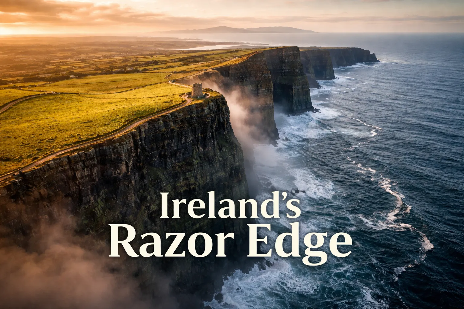
The first time I sent a drone up over the Cliffs of Moher, I genuinely held my breath. One moment the screen showed green grass and a crowd of tourists — the next, the earth simply ended. A razor-sharp line of rock dropped 214 metres into the Atlantic, and from 80 metres altitude I could trace every geological stratum in the cliff face like pages in a book that took 300 million years to write. If you’ve come here researching cliffs of moher drone photography ireland, I want to give you the full picture: the compositions that will define your portfolio, the Atlantic wind reality that could end your shoot in minutes, and the regulatory framework you absolutely cannot ignore before you launch. Ireland’s west coast is breathtaking from the ground. From the air, it is something else entirely.
Drone Flight Brief: Cliffs of Moher at a Glance
| GPS Coordinates (Visitor Centre) | 52.9729° N, 9.4264° W |
| GPS Coordinates (Hag’s Head) | 52.9480° N, 9.4644° W |
| Recommended Altitude Range | 50–120 m AGL for cliff-face profiles; 30–60 m for top-down vertigo shots |
| Best Time of Day | 05:30–08:00 (golden hour to mid-morning, before sea winds build) |
| Best Season | Late May to early July (long daylight, calmer mornings, pre-nesting season peak) |
| Drone Regulations Summary | Ireland IAA Open Category applies; Cliffs of Moher is a designated UNESCO Global Geopark and managed site — formal site operator permission required; seasonal seabird nesting restrictions (typically March–August) apply to low-altitude cliff-face flight; always check IAA NOTAM system and contact the Cliffs of Moher Visitor Experience before flying |
| Skill Level Required | Advanced — Atlantic gusts, proximity to cliff edge, and airspace nuances demand strong pilot experience |
What the Cliffs of Moher Aerial View Reveals That Ground Level Never Can
Standing at the visitor-centre wall, you see the cliff profile to your left and right — a dramatic enough view that draws over 1.5 million visitors per year. But the aerial view of the Cliffs of Moher reveals something the ground-level experience structurally prevents you from seeing: the full geometry of the edge. From altitude, the cliff top is unmistakably a razor line — green pasture presses right up to a sheer void on one side, and on the other, nothing but the grey-green Atlantic stretching toward North America. The contrast is almost violent in its clarity.
From a cliffs of moher aerial view drone perspective at around 100 metres, several things snap into focus simultaneously. The 14-kilometre length of the cliff system becomes comprehensible — you can see it curve away to the south toward Hag’s Head and understand you are looking at one of Europe’s great coastal edges in a single frame. O’Brien’s Tower, which appears commanding from ground level, suddenly looks small and precarious, perched absurdly close to the void. The wave action at the cliff base — which you cannot see at all from the top — becomes visible as white explosions against the rock, the Atlantic swell hitting stone it has been hitting for millennia. And on a clear morning, the Aran Islands materialise on the western horizon, floating apparitions of limestone in the bay. These are the shots that justify the trip.
One detail that genuinely surprised me from altitude: the seabird ledges. The cliff faces are not smooth — they are stratified into horizontal shelves that host tens of thousands of razorbills, guillemots, and puffins during breeding season. From directly above, these ledges appear as faint horizontal lines in the rock face, but in a profile shot at the right angle, you can see the birds themselves as a texture on the cliff wall. It is one of the few places where a drone photograph can simultaneously be a wildlife image, a geological study, and a landscape shot.
The Best Shots to Capture: Compositions for Cliffs of Moher Drone Photography Ireland
The Razor Edge Profile Shot
Position your drone at 80–100 metres altitude, roughly 150 metres out from the cliff edge over the sea, and shoot back toward the coast with the drone pitched slightly upward. This reveals the geological layering in extraordinary detail — the alternating bands of Namurian shale and sandstone that run horizontally across the cliff face like a compressed timeline of Earth history. The best light for this shot is low-angle morning sun from the east, which rakes across the cliff face and throws every stratum into sharp relief. Shoot in the 16:9 or 4:3 ratio and give yourself room at the top of the frame for the green pasture edge — that contrast between the living agricultural land and the geological exposure is the whole story of this landscape.
The Top-Down Vertigo Shot
This is the shot that stops scroll. Position the drone directly over the cliff edge at 40–60 metres altitude with the camera pointed straight down at 90 degrees. Below you, the cliff face drops away and the Atlantic appears as a dark void at the bottom of the frame. The cliff-top grass fills one half of the image, the vertical rock face bisects it, and the sea — impossibly far below — closes the composition. The best time for this shot is overcast bright conditions, when diffuse light eliminates harsh shadows in the rock face and the sea surface shows its full texture without specular glare. Be warned: this shot requires steady hands and a calm wind — any lateral drift at this altitude over the edge is a serious equipment and safety risk.
O’Brien’s Tower with Aran Islands on the Horizon
At 120 metres altitude, positioned southeast of O’Brien’s Tower, shoot northwest with a 35mm equivalent focal length or wider. The tower occupies the lower-centre of the frame, the cliff edge runs diagonally, and on clear mornings (visibility of 40+ km is achievable in the clean Atlantic air) the three Aran Islands — Inis Mór, Inis Meáin, and Inis Oírr — appear as dark shapes in Galway Bay on the horizon. This composition communicates the full geographic drama of the location: you are at the far western edge of continental Europe, looking out toward nothing but open ocean for thousands of kilometres. Golden hour light from the east backlit against a pale sky makes this a portfolio-defining image.
Hag’s Head: The Less-Crowded Alternative
Hag’s Head, at the southern terminus of the cliff system, is where I would send any serious aerial photographer first. The coastal promontory here is wilder, less managed, and the ruins of Moher Tower sit on the headland with dramatic geometric presence from above. The cliff angles here also allow longer-lens telephoto drone compositions compressing the cliff layers in a way the more photographed central section does not. Access is via a farm track off the R478 near Liscannor — park respectfully and walk to the headland. The crowds are a fraction of the visitor centre, and the IAA airspace situation is identical. For ireland drone photography coastal cliffs, this is the sleeper location most guides overlook.
Can You Fly a Drone at the Cliffs of Moher? Regulations and Practical Reality
Here is the honest answer: drone flying at the Cliffs of Moher is legal under Irish aviation law but subject to meaningful restrictions that you must understand before you arrive. Ireland’s aviation authority, the IAA (Irish Aviation Authority), regulates drones under the EU Open Category framework. For most consumer drones under 250g (like the DJI Mini series), operations in the Open Category A1 subcategory apply, meaning you can fly without specific operator registration in many scenarios. Drones between 250g–900g fall under A1/A3 subcategories with registration requirements. Importantly: you must be a registered drone operator with the IAA if flying a registered-class drone, and you must hold a valid EU remote pilot competency certificate appropriate to your drone class.
The site-specific reality is more nuanced. The Cliffs of Moher is a UNESCO Global Geopark and operated by Clare County Council as a managed visitor attraction. The site operators have their own drone policy that requires advance written permission for commercial drone operations and strongly discourages recreational drone flight near the cliff edge due to crowd proximity and safety concerns. You should contact the Cliffs of Moher Visitor Experience directly before any flight. The wild atlantic way drone spots including the Cliffs are also subject to seasonal restrictions: from approximately March through August, low-altitude flight directly along the cliff face is environmentally sensitive due to seabird nesting on the ledges. Disturbance to nesting razorbills and guillemots is a genuine concern, and the ethical photographer gives the birds their space during breeding season.
The practical reality on wind: the west coast of Ireland is statistically one of the windiest coastlines in Europe. Wind speeds above the cliff edge regularly exceed 30–40 km/h by mid-morning, and the thermal dynamics at the cliff-void interface are genuinely unpredictable. The cliff edge creates a severe updraft as Atlantic winds hit the vertical rock face — I have had a drone pitched 30 degrees nose-down fighting a gust that appeared within seconds of a calm window. The absolute best flight window at the Cliffs of Moher is 05:30–08:00 in June and early July, when overnight pressure systems have partially calmed and the sea breeze has not yet built. Check Windy.com specifically for the Cliffs of Moher coordinates — the micro-weather here differs significantly from the broader County Clare forecast.
The Wild Atlantic Way Drone Route: Beyond the Cliffs
The Cliffs of Moher are the anchor, but the Wild Atlantic Way between Loop Head in County Clare and Dog’s Bay in Connemara is arguably the finest coastal drone photography route in the British Isles. From the cliffs, drive north on the R478 toward Doolin and then the Burren — the limestone pavement of the Burren from above looks like a cracked desert floor meeting the sea, an image that reads as almost Martian. Continue north to the Aran Islands (accessible by ferry from Doolin), where the cliff-top forts of Dún Aonghasa on Inis Mór photograph extraordinarily from altitude — an Iron Age fortress on a 100-metre cliff with nothing to the west but ocean. North through Connemara, the patchwork of lakes, blanket bog, and white-sand beaches at Renvyle and Dog’s Bay offer entirely different aerial palettes. Plan at minimum four days to do this route properly with drone gear.
Gear Worth Packing for Atlantic Coastal Drone Photography
The Atlantic coast environment is one of the most demanding for drone hardware. Salt air, cold temperatures, high winds, and the simple distance from any repair service mean that having the right backup components is not optional — it is the difference between a successful expedition and an expensive disaster. These are the specific products I pack for coastal Ireland work.
The Bwine Drone Original Propellers for F7GIM — 4 Pcs Dark Grey & Orange are the specific spare props I keep in my Ireland kit bag for Bwine platform flights. Propeller integrity is non-negotiable at a location like the Cliffs of Moher, where a single cracked blade tip from a hard landing or storage knock can cause catastrophic vibration during the high-stress, high-wind flying this location demands. I learned this the hard way on a coastal Scotland shoot when a barely-visible nick on a prop translated to severe vibration artefacts across every clip in a full morning’s work — footage I could not recover in post. These OEM-matched propellers ensure the precise blade pitch and balance that third-party alternatives sometimes fail to replicate, which matters enormously when your drone is fighting 25 km/h Atlantic gusts. The high-visibility orange accent is also genuinely useful against an overcast Irish sky when you are tracking a small drone against grey cloud at 100 metres. Pack a set as insurance — they weigh almost nothing and could save your entire trip.
For DJI Air 3 and Air 3S users — which covers a significant proportion of serious travel aerial photographers — the Replacement Prop Blades Low Noise Accessories for DJI Mavic Air 3/Air 3S — 8 Pcs Orange Tips are the spare propeller set I specifically recommend for coastal Ireland flying. The low-noise design matters here in a way it might not in a remote wilderness location — the Cliffs of Moher visitor area has significant foot traffic, and generating the least possible acoustic footprint while flying is both courteous to other visitors and reduces the likelihood of drawing attention that could cut your flight window short. Eight blades in the pack means four complete replacement sets, which is the right amount for a week-long expedition where you might be launching from rocky headlands, damp grass, or the boot of a rental car. The orange tips provide the same high-visibility benefit against Irish grey skies, and the precise engineering fit for the Air 3/Air 3S platform means no balance issues that can introduce that telltale vibration shimmer in slow panning shots over the cliff face.
The HUAREW 8Pcs Propellers for DJI Air 3/Air 3S — Low Noise Wing Blade Propeller Blade, 8747F Props Wings Replacement Blades Accessories offer an excellent value backup option for Air 3 and Air 3S operators who want redundancy without duplicating the same product. I carry two propeller sets from different manufacturers on extended coastal expeditions precisely because I have encountered one situation where a specific batch of props had a subtle balance variance that only showed up in-flight — having a second option from a different production run gave me an immediate solution. The 8747F specification is the correct match for the Air 3/Air 3S platform, which matters because cross-compatible-looking props with slightly different pitch will affect both performance and flight characteristics in a way that becomes dangerous in high-wind coastal conditions. At the Cliffs of Moher specifically, where you may be operating at 100+ metres over a 214-metre void, the margin for equipment uncertainty is zero. These props give you a tested, correctly specced backup that adds almost no weight to your travel kit.
This post contains affiliate links. As an Amazon Associate, I earn from qualifying purchases at no extra cost to you.
Frequently Asked Questions About Cliffs of Moher Drone Photography Ireland
Is it legal to fly a drone at the Cliffs of Moher?
Drone flight near the Cliffs of Moher is governed by Irish IAA regulations under the EU Open Category framework. Flying is not outright banned by aviation law, but the site is a managed visitor attraction operated by Clare County Council, and the Cliffs of Moher Visitor Experience requires advance permission for commercial drone operations. Additionally, the site’s designation as a UNESCO Global Geopark and the presence of sensitive nesting seabirds from March to August create practical and ethical restrictions on low-altitude cliff-face flying during those months. The definitive step before any flight is to contact the Cliffs of Moher Visitor Experience directly and check the IAA NOTAM system for any active airspace restrictions at coordinates 52.9729° N, 9.4264° W.
What is the best time of year for drone photography at the Cliffs of Moher?
Late May to early July is the optimal window. Ireland’s summer solstice delivers usable light from approximately 05:00 to 22:00, and early morning in June offers the calmest wind conditions on the west coast before the Atlantic sea breeze builds by mid-morning. Autumn (September–October) offers dramatic storm light and fewer visitors, but wind speeds become significantly less predictable and frequently exceed flyable thresholds for multiple consecutive days. Winter flying is possible in calm windows but daylight is limited to roughly 08:30–16:30 and Atlantic storm systems make planning unreliable. Summer is the clear answer for combining drone flyability, light quality, and the Aran Islands visibility on the horizon that defines the best aerial compositions.
How high should I fly my drone over the Cliffs of Moher?
The most effective altitude range for the Cliffs of Moher is 50–120 metres above ground level for profile and horizon shots, and 30–60 metres for top-down compositions looking directly down the cliff face. Flying above 120 metres AGL in the Open Category requires specific authorisation and is generally unnecessary for the key compositions here. The most important altitude consideration at this location is not the upper limit but the lower: flying too close to the cliff