
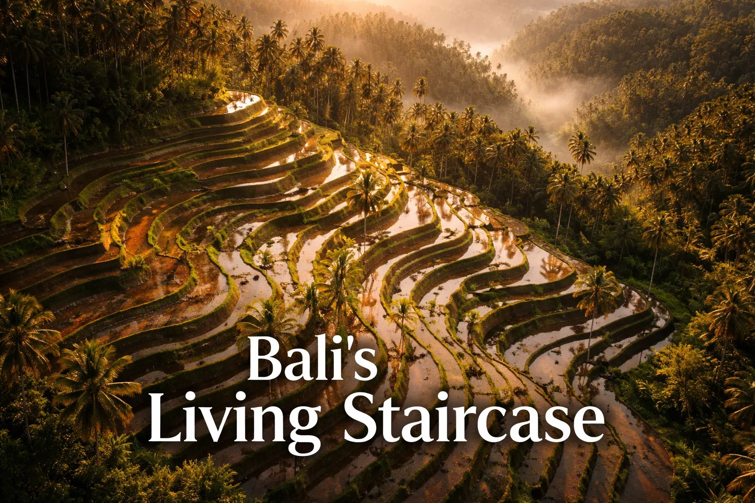
The first time I sent my drone up over Tegallalang, I genuinely gasped. I’d walked the ridge paths, I’d stood at the viewpoints, I’d taken the obligatory ground-level shots — and none of it prepared me for what rice terraces Bali drone photography actually reveals. From about 80 meters up, the valley transforms into something that looks less like farmland and more like a fingerprint carved into the hillside by a giant — thousands of curved, concentric steps following the natural contours of volcanic earth, each one a thin ribbon of green or a mirror of reflected sky, cascading from the forest canopy all the way down to the valley floor. It stopped me in my tracks. Then I started flying.
Bali’s rice terraces — specifically Tegallalang in Gianyar Regency and Jatiluwih in Tabanan — are UNESCO-recognized cultural landscapes, and the aerial view is the only way to truly understand why. The subak cooperative irrigation system that feeds these terraces has operated for over 1,000 years, and from altitude, you can actually see how it works: water descending from hilltop temples through a gravity-fed network of channels and weirs, touching every terrace in the hierarchy before it ever reaches the valley. That network is invisible from the ground. From a drone, it reads like a map of something sacred.
Drone Flight Brief: Rice Terraces Bali Aerial Photography at a Glance
| Detail | Tegallalang | Jatiluwih |
|---|---|---|
| GPS Coordinates | -8.4316° S, 115.2781° E | -8.3753° S, 115.0939° E |
| Recommended Altitude | 60–120m (valley width limits higher shots) | 100–200m (open panoramic terrain) |
| Best Time of Day | 6:30–8:30 AM (golden hour, minimal crowd noise) | 6:00–8:00 AM or 4:30–6:00 PM |
| Best Season | Nov–Mar (flooded, mirror reflections) | Apr–Aug (lush green growth, clear skies) |
| Drone Regulations | Registration required via DitJenHubud; fly under 120m; no flight over crowds or ceremonies | Same national rules apply; fewer crowds, easier compliance |
| Skill Level | Intermediate (tight valley, thermal winds) | Beginner–Intermediate (open terrain, more forgiving) |
| Permit Required? | National registration only — no site-specific permit as of 2024 | National registration only |
What the Aerial View Reveals: The Subak System From Above
Stand anywhere along Tegallalang’s main ridge road and you’ll see terraces. Walk down into the valley and you’ll feel them. But rise to 100 meters in the air and you’ll finally understand them. The subak water management system — the reason these terraces earned UNESCO status in 2012 as part of the “Cultural Landscape of Bali Province” — is fundamentally a system of shared water rights organized around temple hierarchies. From the air, you can trace the main water channel as it descends from the Pura Masceti temple network, branching into smaller channels that feed each farmer’s allocation in sequence. It’s cooperative infrastructure that predates modern engineering by ten centuries, and it’s legible only from altitude.
During the flooded planting season between November and March, the tegallalang rice terraces aerial view becomes something almost surreal. Each flooded terrace acts as a shallow mirror, and from above you’re looking at a staircase of reflected sky climbing the hillside — silver and pale blue steps alternating with the dark green of older growth where different farmers have staggered their planting cycles. The staggering itself is intentional: the subak system deliberately coordinates planting schedules across neighboring plots to interrupt pest cycles, a biological pest management strategy that a Stanford University study identified as one of the most sophisticated traditional agricultural systems on Earth. From 80 meters up, you can see the patchwork of growth stages in a single glance — something no farmer walking between plots could ever see simultaneously.
At Jatiluwih — which sits at roughly 700 meters elevation on the southern slopes of Mount Batukaru — the aerial perspective is entirely different. The terraces here are wider, the steps broader and more gradual, and the volcano rises behind them in a way that only a drone at 150–200 meters captures effectively. On clear mornings before 8 AM, you can frame Batukaru’s dark forested flanks against terraces still catching the low angle of sunrise, with mist sitting in the valley below. No ground-level photograph captures that compression of volcanic mountain, ancient terrace, and low cloud in a single composition.
Rice Terraces Bali Drone Photography: The Best Shots to Capture
The Tegallalang Valley Curve — 70–90m, Nadir or 45°
The defining shot at Tegallalang is a straight-down nadir (or near-nadir at 70–80°) from about 80 meters, positioned over the center of the valley where the terraces curve most dramatically on both sides. This is the composition that looks like a topographic map come to life. Shoot during the flooded season (November–March) and the terraces become concentric rings of mirror. Shoot during the growing season (April–August) and you get an almost neon-green intensity that reads beautifully against the red-brown earth of the paths between plots. The ideal position is roughly 50 meters south of the main viewing bridge — launch from the road shoulder early before vendors and tourists arrive.
The Coconut Palm Frame — 40–60m, Low Angle Sweep
Tegallalang’s scattered coconut palms are compositional gifts from below but something else entirely from a drone at 40–60 meters. At this altitude, flying just above the canopy line, the palms become natural framing elements — their feathered tops appearing in the foreground of the shot while the terrace layers recede behind them. A slow lateral tracking shot at this height, moving parallel to the valley slope, is one of the most cinematic sequences you can capture here. Keep your gimbal at roughly 60–70° downward tilt to maintain both the palm tops and enough of the terraces to establish context. This works best in early morning when the low sun catches the individual fronds and creates texture in the canopy.
Jatiluwih Panoramic With Batukaru — 150–200m, 30–45° Tilt
For the definitive Jatiluwih rice terraces from above composition, position your drone at 150–200 meters, gimbal tilted between 30–45° downward, with Mount Batukaru centered or slightly off-axis in the upper third of the frame. The best launch point is near the Jatiluwih parking area at the western end of the UNESCO scenic road — from here you have unobstructed access to airspace over the terraces while staying clear of the few small temples along the route. This is a wide, landscape-orientation shot: the terraces fill the lower two-thirds of the frame in layered horizontal lines, and the mountain provides vertical drama behind them. In the dry season, when Batukaru is capped with cloud, the resulting image looks genuinely impossible — like CGI.
Can You Fly a Drone at Bali’s Rice Terraces? Indonesia Drone Regulations Explained
The honest answer for most drone photographers: yes, Bali is drone-friendly by regional standards, with the right preparation. Indonesia’s drone regulations are governed by the Directorate General of Civil Aviation (DitJenHubud) under Ministry of Transportation Regulation PM 37 of 2020. The key rules that apply to recreational and travel photography at the rice terraces are these:
- Maximum altitude: 120 meters above ground level in uncontrolled airspace
- Registration: Drones over 250g require registration through the DitJenHubud online portal before flying. This is straightforward for foreign visitors — the process is done online, takes roughly 30 minutes, and costs a nominal fee.
- Drones under 250g (like the DJI Mini 4 Pro and Mini 5 Pro) have a simplified registration pathway and far fewer operational restrictions — a significant practical advantage in the field.
- No-fly zones: Bali’s main airport (Ngurah Rai) has a 5km controlled zone. Neither Tegallalang nor Jatiluwih falls within any published restricted zone as of 2024 — always verify via the AirVisual or Drone Deploy apps before each flight.
- Cultural sensitivity rule: This is the one the apps don’t tell you. Never fly during or immediately over an active temple ceremony or religious procession. Beyond being disrespectful, it creates real community friction — and local authorities have the power to ask you to cease operations immediately. I always check with the nearest warung owner or farmer about ceremony schedules before setting up.
The practical reality for Bali drone photography guide purposes: Tegallalang has a small local levy (usually collected at the main viewpoint entrance) and some warung owners near popular launch spots have started informally requesting donations from drone operators — Rp 20,000–50,000 is reasonable and maintains goodwill with the community whose land you’re flying over. Pay it. It’s approximately $1–3 USD and it matters.
Best Time to Photograph Bali’s Rice Terraces From Above
The two seasons offer genuinely different subjects, not just different lighting. November through March (the flooded planting season) is when the mirror-terrace phenomenon occurs. Individual farmers flood their plots to prepare for planting, and since the subak system staggers planting dates across neighboring plots, you get a mosaic of flooded silver mirrors and vivid green shoots in the same frame simultaneously. The light during this wet season period is often dramatic — big cumulus clouds, shafts of sunlight breaking through — which suits drone photography well if you’re willing to wait out the afternoon rain and fly in the morning window. Humidity is high and affects battery performance slightly.
April through August (the growing and harvest season) brings the lush green color that defines Bali’s postcard image. Terraces in full growth are a deep, saturated green that aerial photography captures with stunning intensity — especially in early morning when the low sun creates long shadows across the terrace walls, giving the landscape its three-dimensional depth. This is also the drier season, which means cleaner air, better visibility to Mount Batukaru at Jatiluwih, and more reliable morning conditions. For first-time visitors, this is the season I’d recommend for pure photographic accessibility — the conditions are more predictable and the color palette is extraordinary.
Regardless of season, golden hour is non-negotiable. The first 90 minutes after sunrise give you warm directional light that rakes across the terrace walls and creates the texture that makes aerial rice terrace photography distinctive. By mid-morning, the light flattens and the compositions lose much of their drama. I’ve done dozens of flights at Tegallalang and the shots that matter are almost always from before 8:30 AM.
Gear Worth Packing: Aerial Photography Equipment for the Rice Terraces
If you’re choosing a drone specifically for Bali’s rice terraces and want the best balance of portability, image quality, and regulatory simplicity, the DJI Mini 4 Pro Fly More Combo Plus with DJI RC 2 is the setup I’d confidently hand to someone heading to Tegallalang for the first time. At under 249 grams, it falls into the simplified registration category under Indonesian drone law — a meaningful advantage when you’re navigating foreign aviation bureaucracy from a guesthouse in Ubud the night before your early shoot. The Fly More Combo Plus includes three Intelligent Flight Battery Plus units giving up to 135 minutes of combined flight time, which matters enormously at Jatiluwih where the drive to the site is significant and you want every minute in the air to count. The RC 2 controller with its built-in screen eliminates the problem of trying to see a phone display in Bali’s intense tropical sunlight — I can’t overstate how much difference that makes when you’re making fine composition adjustments with your eyes on the horizon. The 4K camera with its 1/1.3-inch CMOS sensor handles the high-contrast tropical light of Bali — the bright sky against dark volcanic soil — far better than older Mini-series sensors.
For photographers who want to invest in the most capable sub-250g drone currently available for travel, the DJI Mini 5 Pro Fly More Combo with DJI RC 2 is the one I’d recommend without hesitation for capturing Jatiluwih’s wide panoramic shots. The 1-inch CMOS sensor is the breakthrough feature here — it’s the same sensor size class used in serious prosumer cameras, and at Jatiluwih where you’re often flying into the sun at low morning angles to frame Mount Batukaru, that larger sensor’s dynamic range means you retain detail in both the bright volcanic sky and the shadowed terrace walls simultaneously. The 225° gimbal rotation opens up creative angles that fixed-tilt gimbals simply can’t access — there were compositions I attempted at Tegallalang that required a slightly upward gimbal tilt to capture the curve of the terraces against the sky, and this drone handles that where others don’t. ActiveTrack 360° is genuinely useful for slow orbital shots around the coconut palm clusters, keeping the subject locked while the background rotates. For anyone planning to publish or license aerial Bali photography commercially, the 1-inch sensor is the tool the image demands.
There’s a version of the rice terraces shoot that goes wrong, and it usually goes wrong because of storage or protection — not piloting skill. The DJI Mini 4 Pro bundle with 128GB Memory Card, Landing Pad, and CPS 2-Year Warranty addresses three failure points I’ve personally encountered on tropical aerial shoots. The 128GB card matters more in Bali than you’d think — shooting 4K HDR at 60fps during the flooded-terrace season fills cards faster than you expect, and standing in a muddy terrace path trying to swap storage while the golden-hour light is burning is genuinely painful. The landing pad is the unsung hero of this bundle: Bali’s terrace edges are narrow, muddy, uneven, and often sloped, and a bright orange landing pad gives you a clean surface that your drone’s vision sensors recognize, reducing the likelihood of a botched auto-landing on wet soil. I’ve seen drones tip on wet grass at the moment of landing and it’s an avoidable disaster. The CPS 2-Year Warranty is the real peace-of-mind purchase for international travel shooting — one moisture incident in Bali’s humid conditions, one unexpected thermal wind at Tegallalang, and that warranty pays for itself many times over.
This post contains affiliate links. As an Amazon Associate, I earn from qualifying purchases at no extra cost to you.
Frequently Asked Questions
Is drone photography allowed at Tegallalang Rice Terraces?
Yes, drone photography is permitted at Tegallalang under Indonesian national regulations, provided your drone is registered through the DitJenHubud system and you fly below 120 meters in uncontrolled airspace. There is no site-specific ban or permit requirement at Tegallalang as of 2024. However, you should always check for active temple ceremonies before flying — flying during a religious event is considered deeply disrespectful by the local Balinese community and may result in requests to cease operations. A small informal donation to local warung owners near your launch point is also strongly recommended as a courtesy to the farming community whose land you are photographing from above.
What is the best time of year for rice terraces Bali drone photography?
The two most photogenic seasons serve different creative goals. November through March (the wet/planting season) produces the famous mirror-terrace effect: flooded plots reflect the sky, creating a staircase of silver and blue climbing the hillside. April through August (the dry/growing season) delivers the lush green color most associated with Bali’s rice terrace imagery, with cleaner air and better visibility to volcanic backdrops. For first-time visitors, the April–August dry season offers more consistent conditions and predictable light. For photographers